
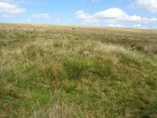
Prehistoric sites within 3km of SX 62500 86650
Guidance for walkers: The monuments featured in this database are archaeological treasures and need to be protected and preserved - please do not disturb any sites. Please check access and firing times before visiting sites, not all sites listed are on open access land. Firing ranges and boundaries of open access areas are marked on the OL28 OS Dartmoor Explorer map. Please stick to the country code and consider giving support to the numerous agencies that help to keep Dartmoor a fabulous natural and historic environment!
About the database listings: In all listings clicking on the photo or the site name will open a page for the site with a larger photo and further details from the database. The database now has over 6680 records covering nearly all publicly listed sites on Dartmoor including around 4800 round houses. This level of detail is of interest to archaeologists but tends to swamp listings of sites more likely to be of interest for walkers. For this reason, the listings default to around 550 core sites only. These are the stone circles, stone rows and the ring cairns listed by Turner. The default search radius is 2 km. The controls below the map can be used to start a new search by entering a 6- or 8-digit reference (without the prefix "SX"). The search radius can be specified and you can add incremental Display layers of detail on top of the core sites. If using a more detailed layer you will need to decrease the search radius to avoid getting hundreds of search results.
- Core sites Default listing of core sites consisting of stone circles & rows and some of the major ring cairns.
- Plus cairns adds approx. 1000 cairns and other minor sites not included in the core listings but excluding round houses.
- Plus round houses adds approx. 4800 round houses.
- Plus non-sites adds in the records for sites that no longer exist or are not prehistoric sites.
- Plus duplicates adds records excluded as duplicates. Those maybe duplicate records in external listings (e.g. the Historic Environment Records). For example, some sites have been identified as cairns in some listings and interpreted as round houses in other listings and both records appear.
These listings have incorporated, matched up and merged all of the records from all of the major archaeological listings including: Worth, Grinsell, Turner, Butler, Bill Radcliffe, Sandy Gerrard, Megalithic Portal, the National Monument Records and the Historic Environment Records. The author would like to thank Bill, Sandy, the lovely people both at Megalithic Portal (especially Anne Tate who did an amazing job to link listings) and at ACE Archaeology for collaborative work over the years to synchronise and correct listings across the various websites which now interlink. A culmination of years of work the final merger of cairn records took 3 months of cross referencing in 2017 the result being a snapshot of the records at that time. This data has in turn been refined since by field work and research. The round house data was supplied by Sandy Gerrard. Grid references are in order of accuracy: from Google Earth satellite, if visible and found, from a Garmin GPS reading, if visited by the author and from the literature otherwise. Individual site pages will state the source of the grid reference and provide satellite imagery. If a site listing lacks a photo it has not yet been visited by the author in which case the grid reference is from the literature.
Currently the database only includes sites which can be represented by a grid reference. Reaves are not included as they require GIS shape technology which is beyond the current capability of this system. To see the sources for the records, look at the tables on the resources menu. The database listings can also be viewed on a Google map and downloaded as GPS datasets for Garmin devices.
Corrections, or any feedback or suggestions are very welcome, email: info@dartmoorwalks.org.uk.
NOTE: Clicking on the icons for each monument in the map will give the name of the site. You can zoom in and out and drag the map around.
List of sites within 3km of SX 62500 86650
Gidleigh Common Round House
OS Map: SX 6511 8750
HER: MDV59587
ShortName: HT:Gidleigh 3
Nearby sites: SX 6511 8750
Distance: 2.74km
Gidleigh Common Round House
OS Map: SX 6514 8754
HER: MDV59586
ShortName: HT:Gidleigh 4
Nearby sites: SX 6514 8754
Distance: 2.79km
Gidleigh Common Round House
OS Map: SX 652 875
HER: MDV59405
ShortName: HT:Gidleigh 5
Nearby sites: SX 652 875
Distance: 2.83km
Manga Brook Crop Mark
OS Map: SX 6305 8478
HER: MDV27298
ShortName: CN?Manga Brook
Notes: Aerial Photograph
Nearby sites: SX 6305 8478
Distance: 1.95km
Shovel Down Round House
OS Map: SX 65234 86110
HER: MDV58333
ShortName: HT:Shovel Do1
Nearby sites: SX 65234 86110
Distance: 2.79km
Steeperton Tor, NE of Reported Cairn
OS Map: SX 6204 8907
HER: MDV19986
ShortName: CN?Steeperto1
Grinsell: LYD 5
Notes: Cairn with retaining circle. Hillslope siting. Diameter 5.5m. May be that recorded by crossing in 'guide to dartmoor' (1907) p 207 (grinsell)
Nearby sites: SX 6204 8907
Distance: 2.46km
Shovel Down Round House
OS Map: SX 65242 85951
HER: MDV58324
ShortName: HT:Shovel Do2
Nearby sites: SX 65242 85951
Distance: 2.83km
Shovel Down Round House
OS Map: SX 65232 85898
HER: MDV58322
ShortName: HT:Shovel Do3
Nearby sites: SX 65232 85898
Distance: 2.83km
Shovel Down Round House
OS Map: SX 65247 85755
HER: MDV58334
ShortName: HT:Shovel Do4
Nearby sites: SX 65247 85755
Distance: 2.89km
Shovel Down Round House
OS Map: SX 65244 85874
HER: MDV58319
ShortName: HT:Shovel Do5
Nearby sites: SX 65244 85874
Distance: 2.85km
Shovel Down Round House
OS Map: SX 65228 85888
HER: MDV58321
ShortName: HT:Shovel Do6
Nearby sites: SX 65228 85888
Distance: 2.83km
Shovel Down Round House
OS Map: SX 65227 85876
HER: MDV58320
ShortName: HT:Shovel Do7
Nearby sites: SX 65227 85876
Distance: 2.83km
Shovel Down Round House
OS Map: SX 65228 85921
HER: MDV58323
ShortName: HT:Shovel Do8
Nearby sites: SX 65228 85921
Distance: 2.82km
Shovel Down Round House
OS Map: SX 65213 86034
HER: MDV28157
ShortName: HT:Shovel Do9
Nearby sites: SX 65213 86034
Distance: 2.78km
Manga Rock SE Round House
OS Map: SX 63853 85596
HER: MDV54484
ShortName: HT:Manga Roc1
Nearby sites: SX 63853 85596
Distance: 1.72km
Shovel Down Round House
OS Map: SX 65214 85993
HER: MDV28157
ShortName: HT:Shovel Do11
Nearby sites: SX 65214 85993
Distance: 2.79km
Manga Rock SE Round House
OS Map: SX 63846 85602
HER: MDV54485
ShortName: HT:Manga Roc2
Nearby sites: SX 63846 85602
Distance: 1.71km
Shovel Down Round House
OS Map: SX 65333 85987
HER: MDV58330
ShortName: HT:Shovel Do12
Nearby sites: SX 65333 85987
Distance: 2.91km
Manga Rock SE Round House
OS Map: SX 63837 85594
HER: MDV54483
ShortName: HT:Manga Roc3
Nearby sites: SX 63837 85594
Distance: 1.70km
Shoveldown N.W.7 Cairn
OS Map: SX 6423 8622
HER: MDV37096
ShortName: CN:Shovel NW7
Nearby sites: SX 6423 8622
Distance: 1.78km
Ruelake Pit Round House
OS Map: SX 6406 8881
HER: MDV64830
ShortName: HT:Ruelake P1
Nearby sites: SX 6406 8881
Distance: 2.66km
Ruelake Pit Round House
OS Map: SX 6399 8874
HER: MDV65389
ShortName: HT:Ruelake P2
Nearby sites: SX 6399 8874
Distance: 2.57km
Ruelake Pit Round House
OS Map: SX 6395 8875
HER: MDV65388
ShortName: HT:Ruelake P3
Nearby sites: SX 6395 8875
Distance: 2.55km
Shovel Down Round House
OS Map: SX 65344 86030
HER: MDV58329
ShortName: HT:Shovel Do22
Nearby sites: SX 65344 86030
Distance: 2.91km
Kennon Hill S.W.1 Cairn
OS Map: SX 63916 88974
HER: MDV19463
ShortName: CN Kennon SW1
Butler map: 41.1
Notes: Butler describes a heather-covered cairn with a pair of slabs visible in the body of the mound. This cairn is not covered in heather but then this photo is taken 20 year on. There are signs of the slabs in the mound so it is probably the same cairn. The HER refers to another cairn 50m due w of this one - the author could not locate that but then the area is very overgrown.
Nearby sites: SX 63916 88974
Distance: 2.72km
Shovel Down Round House
OS Map: SX 65251 85837
HER: MDV58318
ShortName: HT:Shovel Do23
Nearby sites: SX 65251 85837
Distance: 2.87km
Watern Tor S. Cairn
OS Map: SX 62912 86086
HER: MDV4376
ShortName: CN:Watern To2
Butler map: 41.3
Grinsell: LYD 8
Notes: "Cairn lies east of Hangingstone Hill. Measures 23 metres in length, 19.5 metres wide and 2.0 metres high."
Nearby sites: SX 62912 86086
Distance: 0.70km
Shovel Down Round House
OS Map: SX 65331 85983
HER: MDV58330
ShortName: HT:Shovel Do24
Nearby sites: SX 65331 85983
Distance: 2.91km
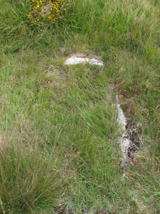
Watern Tor Reported Cairn
OS Map: SX 6291 8682
HER: MDV4390
ShortName: CN:Watern To1
Butler map: 41.4
Grinsell: LYD 7
Notes: "Cairn on watern tor (diam 5.5m, height 500mm) granite slab (length 1.5m, width 1.0m, thick 250mm)". "1976 (grinsell) shown on os as cairn, but seems to be a natural outcrop." Scheduled Monument 1017482: Round cairn on Watern Tor.
Nearby sites: SX 6291 8682
Distance: 0.44km
Shovel Down Round House
OS Map: SX 65281 86023
HER: MDV58326
ShortName: HT:Shovel Do25
Nearby sites: SX 65281 86023
Distance: 2.85km
Shovel Down Round House
OS Map: SX 65285 86367
HER: MDV54533
ShortName: HT:Shovel Do26
Nearby sites: SX 65285 86367
Distance: 2.80km
Hangingstone Hill N. Reported Cairn
OS Map: SX 6172 8643
ShortName: CNxHangingst4
Butler map: 41.5
Notes: A cairn was alleged at this location but there is no ground evidence
Nearby sites: SX 6172 8643
Distance: 0.81km
Shovel Down Round House
OS Map: SX 65269 85807
HER: MDV58315
ShortName: HT:Shovel Do27
Nearby sites: SX 65269 85807
Distance: 2.89km
Wild Tor N.E. (exc. 1900) Cairn
OS Map: SX 62912 88080
HER: MDV4370
ShortName: CN:Wild Tor 2
Butler map: 41.6
Grinsell: THR 1
Notes: This is probably the cist and cairn excavated by Baring-Gould c1900. No trace of a cist today. See also THR 2 NMR 443776. THR 1, 2
Nearby sites: SX 62912 88080
Distance: 1.49km
Shovel Down Round House
OS Map: SX 65277 86121
HER: MDV58332
ShortName: HT:Shovel Do28
Nearby sites: SX 65277 86121
Distance: 2.83km
Shovel Down Round House
OS Map: SX 65269 85854
HER: MDV58317
ShortName: HT:Shovel Do29
Nearby sites: SX 65269 85854
Distance: 2.88km
Shovel Down Round House
OS Map: SX 65257 85870
HER: MDV58318
ShortName: HT:Shovel Do30
Nearby sites: SX 65257 85870
Distance: 2.87km
Shovel Down Round House
OS Map: SX 65255 85826
HER: MDV58316
ShortName: HT:Shovel Do31
Nearby sites: SX 65255 85826
Distance: 2.88km
Kennon Hill S.2 Reported Cairn
OS Map: SX 6453 8835
HER: MDV64130
ShortName: CN:KennonHill2
Notes: 2 cairns and 1 cairn and cist at Kennock Hill South (HER 64130, HER 61776, HER 64129)
Nearby sites: SX 6453 8835
Distance: 2.65km
Shovel Down Round House
OS Map: SX 65364 85973
HER: MDV58331
ShortName: HT:Shovel Do32
Nearby sites: SX 65364 85973
Distance: 2.94km
Kennon Hill S.3 Reported Cairn
OS Map: SX 6468 8826
HER: MDV64129
ShortName: CN:KennonHill3
Notes: 2 cairns and 1 cairn and cist at Kennock Hill South (HER 64130, HER 61776, HER 64129)
Nearby sites: SX 6468 8826
Distance: 2.71km
Shovel Down NW Round House
OS Map: SX 6454 8655
HER: MDV58286
ShortName: HT:Shovel Do33
Nearby sites: SX 6454 8655
Distance: 2.04km
Shovel Down NW Round House
OS Map: SX 64587 86562
HER: MDV58289
ShortName: HT:Shovel Do34
Nearby sites: SX 64587 86562
Distance: 2.09km
Shovel Down NW Round House
OS Map: SX 64599 86506
HER: MDV58290
ShortName: HT:Shovel Do35
Nearby sites: SX 64599 86506
Distance: 2.10km
Wallabrook Bridge (SW of) cairn cemetery 1-9 Reported Cairn
OS Map: SX 645 868
HER: MDV28132
ShortName: CN:WallabrooA
Nearby sites: SX 645 868
Distance: 2.01km
Shovel Down NW Round House
OS Map: SX 64562 86544
HER: MDV58287
ShortName: HT:Shovel Do36
Nearby sites: SX 64562 86544
Distance: 2.06km
Wallabrook Bridge (SW of) 1 Cairn
OS Map: SX 64635 86994
HER: MDV34258
ShortName: CN:Wallabroo1
Nearby sites: SX 64635 86994
Distance: 2.16km
Shovel Down NW Round House
OS Map: SX 64575 86553
HER: MDV58288
ShortName: HT:Shovel Do37
Nearby sites: SX 64575 86553
Distance: 2.08km
Wallabrook Bridge (SW of) 2 Cairn
OS Map: SX 64608 86962
HER: MDV34259
ShortName: CN:Wallabroo2
Nearby sites: SX 64608 86962
Distance: 2.13km
Wallabrook Bridge (SW of) 3 Cairn
OS Map: SX 64577 86932
HER: MDV34260
ShortName: CN:Wallabroo3
Nearby sites: SX 64577 86932
Distance: 2.10km
Walla Brook S Round House
OS Map: SX 6389 8689
HER: MDV61442
ShortName: HT:Walla Bro1
Nearby sites: SX 6389 8689
Distance: 1.41km
Wallabrook Bridge (SW of) 4 Cairn
OS Map: SX 64554 86897
HER: MDV34261
ShortName: CN:Wallabroo4
Nearby sites: SX 64554 86897
Distance: 2.07km
Walla Brook S Round House
OS Map: SX 6390 8711
HER: MDV61445
ShortName: HT:Walla Bro2
Nearby sites: SX 6390 8711
Distance: 1.47km
Wallabrook Bridge (SW of) 5 Cairn
OS Map: SX 64447 86944
HER: MDV34262
ShortName: CN:Wallabroo5
Nearby sites: SX 64447 86944
Distance: 1.97km
Walla Brook S Round House
OS Map: SX 6392 8713
HER: MDV27703
ShortName: HT:Walla Bro3
Nearby sites: SX 6392 8713
Distance: 1.50km
Okement Hill N. Reported Cairn
OS Map: SX 603 880
ShortName: CN?Okement H1
Butler map: 42.
Notes: Butler: Crossing recorded two more cairns in the area". The NMR record has a slightly different guessed NGR.
Nearby sites: SX 603 880
Distance: 2.58km
Wallabrook Bridge (SW of) 6 Cairn
OS Map: SX 64511 86871
HER: MDV34263
ShortName: CN:Wallabroo6
Nearby sites: SX 64511 86871
Distance: 2.02km
Walla Brook S Round House
OS Map: SX 6392 8712
HER: MDV61444
ShortName: HT:Walla Bro4
Nearby sites: SX 6392 8712
Distance: 1.50km
Okement Hill Summit Reported Cairn
OS Map: SX 603 877
HER: MDV4369
ShortName: CNxOkement H2
Butler map: 42.
Grinsell: LYD 5a
Notes: Doubtful - probable peat stack. NGR supplied by Grinsell.
Nearby sites: SX 603 877
Distance: 2.44km
Wallabrook Bridge (SW of) 7 Cairn
OS Map: SX 64458 86912
HER: MDV34264
ShortName: CN:Wallabroo7
Nearby sites: SX 64458 86912
Distance: 1.98km
Walla Brook S Round House
OS Map: SX 6394 8688
HER: MDV61443
ShortName: HT:Walla Bro5
Nearby sites: SX 6394 8688
Distance: 1.46km
Wallabrook Bridge (SW of) 8 Cairn
OS Map: SX 64462 86847
HER: MDV34265
ShortName: CN:Wallabroo8
Nearby sites: SX 64462 86847
Distance: 1.97km
Walla Brook S Round House
OS Map: SX 6390 8689
HER: MDV61441
ShortName: HT:Walla Bro6
Nearby sites: SX 6390 8689
Distance: 1.42km
Wallabrook Bridge (SW of) 9 Cairn
OS Map: SX 64455 86815
HER: MDV34266
ShortName: CN:Wallabroo9
Nearby sites: SX 64455 86815
Distance: 1.96km
Walla Brook S Round House
OS Map: SX 6394 8693
HER: MDV61440
ShortName: HT:Walla Bro7
Nearby sites: SX 6394 8693
Distance: 1.47km
Walla Brook S Round House
OS Map: SX 6392 8690
HER: MDV27699
ShortName: HT:Walla Bro8
Nearby sites: SX 6392 8690
Distance: 1.44km
Walla Brook S Round House
OS Map: SX 6392 8691
HER: MDV61439
ShortName: HT:Walla Bro9
Nearby sites: SX 6392 8691
Distance: 1.44km
Walla Brook S Round House
OS Map: SX 6393 8690
HER: MDV61438
ShortName: HT:Walla Bro10
Nearby sites: SX 6393 8690
Distance: 1.45km
Teignhead Newtake 2 (duplicate) Reported Cairn
OS Map: SX 625 845
HER: MDV54673
ShortName: CN:Teignhead3
Notes: Duplicate of HER 6796
Nearby sites: SX 625 845
Distance: 2.65km
Langridge Newtake Cairn
OS Map: SX 6420 8476
HER: MDV54686
ShortName: CN:Langridge1
Nearby sites: SX 6420 8476
Distance: 2.54km
Steeperton Gorge Round House
OS Map: SX 6162 8938
HER: MDV27710
ShortName: HT:Steeperto1
Nearby sites: SX 6162 8938
Distance: 2.87km
Steeperton Gorge Round House
OS Map: SX 6169 8950
HER: MDV60308
ShortName: HT:Steeperto2
Nearby sites: SX 6169 8950
Distance: 2.96km
Steeperton Gorge Round House
OS Map: SX 6160 8924
HER: MDV27709
ShortName: HT:Steeperto3
Nearby sites: SX 6160 8924
Distance: 2.74km
Steeperton Gorge Round House
OS Map: SX 6159 8928
HER: MDV60311
ShortName: HT:Steeperto4
Nearby sites: SX 6159 8928
Distance: 2.78km
Shoveldown N.W.8 Cairn
OS Map: SX 6452 8592
HER: MDV58285
ShortName: CN:Shovel NW8
Nearby sites: SX 6452 8592
Distance: 2.15km
Steeperton Tor NE Round House
OS Map: SX 6225 8892
HER: MDV60293
ShortName: HT:Steeperto5
Nearby sites: SX 6225 8892
Distance: 2.28km
Steeperton Tor NE Round House
OS Map: SX 6216 8904
HER: MDV4388
ShortName: HT:Steeperto6
Nearby sites: SX 6216 8904
Distance: 2.41km
Steeperton Tor NE Round House
OS Map: SX 6215 8906
HER: MDV4388
ShortName: HT:Steeperto7
Nearby sites: SX 6215 8906
Distance: 2.44km
Steeperton Tor NE Round House
OS Map: SX 6217 8905
HER: MDV4388
ShortName: HT:Steeperto8
Nearby sites: SX 6217 8905
Distance: 2.42km
Kennon Hill Round House
OS Map: SX 64166 89031
HER: MDV4387
ShortName: HT:Kennon Hi1
Nearby sites: SX 64166 89031
Distance: 2.91km
Steeperton Tor NE Round House
OS Map: SX 6223 8896
HER: MDV34257
ShortName: HT:Steeperto9
Nearby sites: SX 6223 8896
Distance: 2.33km
Kennon Hill Round House
OS Map: SX 64168 89047
HER: MDV4387
ShortName: HT:Kennon Hi2
Nearby sites: SX 64168 89047
Distance: 2.92km
Steeperton Tor NE Round House
OS Map: SX 6218 8895
HER: MDV60294
ShortName: HT:Steeperto10
Nearby sites: SX 6218 8895
Distance: 2.32km
Kennon Hill S.W.2 Reported Cairn
OS Map: SX 6387 8898
HER: MDV58865
ShortName: CN:Kennon SW2
Notes: The HER refers to another cairn 50m due w of the Kennon Hill S.W. Cairn - the author could not locate that on 27/08/17 but then the area is very overgrown.
Nearby sites: SX 6387 8898
Distance: 2.70km
Kennon Hill Round House
OS Map: SX 64195 89076
HER: MDV4387
ShortName: HT:Kennon Hi3
Nearby sites: SX 64195 89076
Distance: 2.96km
Steeperton Tor NE Round House
OS Map: SX 6215 8903
HER: MDV4388
ShortName: HT:Steeperto11
Nearby sites: SX 6215 8903
Distance: 2.41km
Gallaven Brook Reported Cairn
OS Map: SX 6409 8764
HER: MDV59155
ShortName: CN?Gallaven Br
Nearby sites: SX 6409 8764
Distance: 1.87km
Kennon Hill Round House
OS Map: SX 64173 89084
HER: MDV4387
ShortName: HT:Kennon Hi4
Nearby sites: SX 64173 89084
Distance: 2.95km
Steeperton Tor NE Round House
OS Map: SX 6209 8907
HER: MDV4388
ShortName: HT:Steeperto12
Nearby sites: SX 6209 8907
Distance: 2.45km
Kennon Hill Round House
OS Map: SX 64177 89022
HER: MDV4387
ShortName: HT:Kennon Hi5
Nearby sites: SX 64177 89022
Distance: 2.90km
Steeperton Tor NE Round House
OS Map: SX 6222 8895
HER: MDV60290
ShortName: HT:Steeperto13
Nearby sites: SX 6222 8895
Distance: 2.32km
Kennon Hill Round House
OS Map: SX 64236 89014
HER: MDV4387
ShortName: HT:Kennon Hi6
Nearby sites: SX 64236 89014
Distance: 2.93km
Steeperton Tor NE Round House
OS Map: SX 6205 8911
HER: MDV4388
ShortName: HT:Steeperto14
Nearby sites: SX 6205 8911
Distance: 2.50km
Kennon Hill Round House
OS Map: SX 64222 89070
HER: MDV4387
ShortName: HT:Kennon Hi7
Nearby sites: SX 64222 89070
Distance: 2.97km
Steeperton Tor NE Round House
OS Map: SX 6213 8903
HER: MDV4388
ShortName: HT:Steeperto15
Nearby sites: SX 6213 8903
Distance: 2.41km
Kennon Hill Round House
OS Map: SX 64226 89046
HER: MDV4387
ShortName: HT:Kennon Hi8
Nearby sites: SX 64226 89046
Distance: 2.95km
Steeperton Tor NE Round House
OS Map: SX 6207 8908
HER: MDV4388
ShortName: HT:Steeperto16
Nearby sites: SX 6207 8908
Distance: 2.47km
Kennon Hill Round House
OS Map: SX 64188 89087
HER: MDV4387
ShortName: HT:Kennon Hi9
Nearby sites: SX 64188 89087
Distance: 2.96km
Steeperton Tor NE Round House
OS Map: SX 6222 8897
HER: MDV60295
ShortName: HT:Steeperto17
Nearby sites: SX 6222 8897
Distance: 2.34km
Kennon Hill Round House
OS Map: SX 64223 89033
HER: MDV4387
ShortName: HT:Kennon Hi10
Nearby sites: SX 64223 89033
Distance: 2.94km
Steeperton Tor NE Round House
OS Map: SX 6210 8914
HER: MDV4388
ShortName: HT:Steeperto18
Nearby sites: SX 6210 8914
Distance: 2.52km
Kennon Hill Round House
OS Map: SX 64207 89040
HER: MDV4387
ShortName: HT:Kennon Hi11
Nearby sites: SX 64207 89040
Distance: 2.94km
Rival Tor N Round House
OS Map: SX 6454 8838
HER: MDV64126
ShortName: HT:Rival Tor1
Nearby sites: SX 6454 8838
Distance: 2.67km
Steeperton Tor NE Round House
OS Map: SX 6222 8891
HER: MDV60292
ShortName: HT:Steeperto19
Nearby sites: SX 6222 8891
Distance: 2.28km
Kennon Hill Round House
OS Map: SX 64211 89066
HER: MDV4387
ShortName: HT:Kennon Hi12
Nearby sites: SX 64211 89066
Distance: 2.96km
Rival Tor N Round House
OS Map: SX 6451 8837
HER: MDV64125
ShortName: HT:Rival Tor2
Nearby sites: SX 6451 8837
Distance: 2.65km
Steeperton Tor NE Round House
OS Map: SX 6211 8906
HER: MDV4388
ShortName: HT:Steeperto20
Nearby sites: SX 6211 8906
Distance: 2.44km
Kennon Hill Round House
OS Map: SX 64215 89066
HER: MDV4387
ShortName: HT:Kennon Hi13
Nearby sites: SX 64215 89066
Distance: 2.96km
Rival Tor N Round House
OS Map: SX 6448 8840
HER: MDV64124
ShortName: HT:Rival Tor3
Nearby sites: SX 6448 8840
Distance: 2.64km
Steeperton Tor NE Round House
OS Map: SX 6211 8903
HER: MDV4388
ShortName: HT:Steeperto21
Nearby sites: SX 6211 8903
Distance: 2.41km
Kennon Hill Round House
OS Map: SX 64182 89070
HER: MDV4387
ShortName: HT:Kennon Hi14
Nearby sites: SX 64182 89070
Distance: 2.95km
Rival Tor N Round House
OS Map: SX 6439 8841
HER: MDV64123
ShortName: HT:Rival Tor4
Nearby sites: SX 6439 8841
Distance: 2.58km
Steeperton Tor NE Round House
OS Map: SX 6213 8907
HER: MDV4388
ShortName: HT:Steeperto22
Nearby sites: SX 6213 8907
Distance: 2.45km
Kennon Hill Round House
OS Map: SX 64179 88982
HER: MDV4387
ShortName: HT:Kennon Hi15
Nearby sites: SX 64179 88982
Distance: 2.87km
Rival Tor NE Round House
OS Map: SX 6459 8826
HER: MDV64128
ShortName: HT:Rival Tor5
Nearby sites: SX 6459 8826
Distance: 2.64km
Steeperton Tor NE Round House
OS Map: SX 6213 8903
HER: MDV4388
ShortName: HT:Steeperto23
Nearby sites: SX 6213 8903
Distance: 2.41km
Kennon Hill Round House
OS Map: SX 64215 89029
HER: MDV4387
ShortName: HT:Kennon Hi16
Nearby sites: SX 64215 89029
Distance: 2.93km
Rival Tor NE Round House
OS Map: SX 6457 8827
HER: MDV64127
ShortName: HT:Rival Tor6
Nearby sites: SX 6457 8827
Distance: 2.63km
Steeperton Tor NE Round House
OS Map: SX 6210 8908
HER: MDV4388
ShortName: HT:Steeperto24
Nearby sites: SX 6210 8908
Distance: 2.46km
Kennon Hill Round House
OS Map: SX 64232 89036
HER: MDV4387
ShortName: HT:Kennon Hi17
Nearby sites: SX 64232 89036
Distance: 2.95km
Rival Tor SE Round House
OS Map: SX 6456 8804
HER: MDV64134
ShortName: HT:Rival Tor7
Nearby sites: SX 6456 8804
Distance: 2.49km
Stonetor Hill Round House
OS Map: SX 65001 85595
HER: MDV58354
ShortName: HT:Stonetor 1
Nearby sites: SX 65001 85595
Distance: 2.71km
Kennon Hill Round House
OS Map: SX 64155 89025
HER: MDV4387
ShortName: HT:Kennon Hi18
Nearby sites: SX 64155 89025
Distance: 2.89km
Rival Tor SE Round House
OS Map: SX 6454 8795
HER: MDV64136
ShortName: HT:Rival Tor8
Nearby sites: SX 6454 8795
Distance: 2.42km
Stonetor Hill Round House
OS Map: SX 65019 85598
HER: MDV58355
ShortName: HT:Stonetor 2
Nearby sites: SX 65019 85598
Distance: 2.73km
Kennon Hill Round House
OS Map: SX 64164 89064
HER: MDV4387
ShortName: HT:Kennon Hi19
Nearby sites: SX 64164 89064
Distance: 2.93km
Rival Tor SE Round House
OS Map: SX 6450 8795
HER: MDV64135
ShortName: HT:Rival Tor9
Nearby sites: SX 6450 8795
Distance: 2.39km
Stonetor Hill Round House
OS Map: SX 65034 85681
HER: MDV58351
ShortName: HT:Stonetor 3
Nearby sites: SX 65034 85681
Distance: 2.71km
Kennon Hill Round House
OS Map: SX 64259 89012
HER: MDV4387
ShortName: HT:Kennon Hi20
Nearby sites: SX 64259 89012
Distance: 2.95km
Rival Tor SE Round House
OS Map: SX 6448 8806
HER: MDV64133
ShortName: HT:Rival Tor10
Nearby sites: SX 6448 8806
Distance: 2.43km
Stonetor Hill Round House
OS Map: SX 65043 85583
HER: MDV58356
ShortName: HT:Stonetor 4
Nearby sites: SX 65043 85583
Distance: 2.76km
Kennon Hill Round House
OS Map: SX 64275 89000
HER: MDV4387
ShortName: HT:Kennon Hi21
Nearby sites: SX 64275 89000
Distance: 2.95km
Stonetor Hill Round House
OS Map: SX 64987 85651
HER: MDV58353
ShortName: HT:Stonetor 5
Nearby sites: SX 64987 85651
Distance: 2.68km
Kennon Hill Round House
OS Map: SX 64158 89037
HER: MDV4387
ShortName: HT:Kennon Hi22
Nearby sites: SX 64158 89037
Distance: 2.91km
Stonetor Hill Round House
OS Map: SX 65064 85456
HER: MDV58357
ShortName: HT:Stonetor 6
Nearby sites: SX 65064 85456
Distance: 2.83km
Kennon Hill Round House
OS Map: SX 64131 89046
HER: MDV4387
ShortName: HT:Kennon Hi23
Nearby sites: SX 64131 89046
Distance: 2.90km
Stonetor Hill Round House
OS Map: SX 65057 85667
HER: MDV58352
ShortName: HT:Stonetor 7
Nearby sites: SX 65057 85667
Distance: 2.74km
Kennon Hill Round House
OS Map: SX 64269 89022
HER: MDV4387
ShortName: HT:Kennon Hi24
Nearby sites: SX 64269 89022
Distance: 2.96km
Stonetor Hill N Round House
OS Map: SX 64760 86032
HER: MDV4401
ShortName: HT:Stonetor 8
Nearby sites: SX 64760 86032
Distance: 2.34km
Stonetor Hill N Round House
OS Map: SX 64769 86049
HER: MDV4401
ShortName: HT:Stonetor 9
Nearby sites: SX 64769 86049
Distance: 2.35km
Stonetor Hill N Round House
OS Map: SX 64769 86041
HER: MDV4401
ShortName: HT:Stonetor 10
Nearby sites: SX 64769 86041
Distance: 2.35km
Stonetor Hill N Round House
OS Map: SX 64759 86061
HER: MDV4401
ShortName: HT:Stonetor 11
Nearby sites: SX 64759 86061
Distance: 2.33km
Stonetor Hill N Round House
OS Map: SX 64877 85881
HER: MDV54498
ShortName: HT:Stonetor 12
Nearby sites: SX 64877 85881
Distance: 2.50km
Stonetor Hill N Round House
OS Map: SX 64759 86074
HER: MDV4401
ShortName: HT:Stonetor 13
Nearby sites: SX 64759 86074
Distance: 2.33km
Stonetor Hill N Round House
OS Map: SX 64762 86010
HER: MDV4401
ShortName: HT:Stonetor 14
Nearby sites: SX 64762 86010
Distance: 2.35km
Stonetor Hill N Round House
OS Map: SX 6468 8605
HER: MDV4680
ShortName: HT:Stonetor 15
Nearby sites: SX 6468 8605
Distance: 2.26km
Stonetor Hill N Round House
OS Map: SX 64737 86014
HER: MDV4401
ShortName: HT:Stonetor 16
Nearby sites: SX 64737 86014
Distance: 2.33km
Stonetor Hill N Round House
OS Map: SX 646 860
HER: MDV58362
ShortName: HT:Stonetor 17
Nearby sites: SX 646 860
Distance: 2.20km
Stonetor Hill N Round House
OS Map: SX 64735 85978
HER: MDV4401
ShortName: HT:Stonetor 18
Nearby sites: SX 64735 85978
Distance: 2.33km
Stonetor Hill SW Round House
OS Map: SX 64552 85274
ShortName: HT:Stonetor 19
Nearby sites: SX 64552 85274
Distance: 2.47km
Stonetor Hill SW Round House
OS Map: SX 64536 85221
HER: MDV4692
ShortName: HT:Stonetor 20
Nearby sites: SX 64536 85221
Distance: 2.49km
Stonetor Hill SW Round House
OS Map: SX 64644 85204
HER: MDV4699
ShortName: HT:Stonetor 21
Nearby sites: SX 64644 85204
Distance: 2.59km
Stonetor Hill SW Round House
OS Map: SX 64605 85149
HER: MDV58341
ShortName: HT:Stonetor 22
Nearby sites: SX 64605 85149
Distance: 2.59km
Stonetor Hill SW Round House
OS Map: SX 64601 85135
HER: MDV4703
ShortName: HT:Stonetor 23
Nearby sites: SX 64601 85135
Distance: 2.59km
Stonetor Hill SW Round House
OS Map: SX 64584 85215
HER: MDV4693
ShortName: HT:Stonetor 24
Nearby sites: SX 64584 85215
Distance: 2.53km
Stonetor Hill SW Round House
OS Map: SX 64545 85283
ShortName: HT:Stonetor 25
Nearby sites: SX 64545 85283
Distance: 2.46km
Stonetor Hill SW Round House
OS Map: SX 64548 85191
HER: MDV4691
ShortName: HT:Stonetor 26
Nearby sites: SX 64548 85191
Distance: 2.51km
Stonetor Hill SW Round House
OS Map: SX 64576 85247
HER: MDV4690
ShortName: HT:Stonetor 27
Nearby sites: SX 64576 85247
Distance: 2.51km
Stonetor Hill SW Round House
OS Map: SX 64564 85082
HER: MDV58342
ShortName: HT:Stonetor 28
Nearby sites: SX 64564 85082
Distance: 2.59km
Stonetor Hill SW Round House
OS Map: SX 64530 85183
HER: MDV4689
ShortName: HT:Stonetor 29
Nearby sites: SX 64530 85183
Distance: 2.50km
Stonetor Hill SW Round House
OS Map: SX 64401 85267
HER: MDV58347
ShortName: HT:Stonetor 30
Nearby sites: SX 64401 85267
Distance: 2.35km
Stonetor Hill SW Round House
OS Map: SX 64397 85238
HER: MDV58346
ShortName: HT:Stonetor 31
Nearby sites: SX 64397 85238
Distance: 2.36km
Stonetor Hill SW Round House
OS Map: SX 64554 85203
HER: MDV4694
ShortName: HT:Stonetor 32
Nearby sites: SX 64554 85203
Distance: 2.51km
Hangingstone Hill (duplicate 1) Reported Cairn
OS Map: SX 61658 86059
HER: MDV115805
ShortName: CN:Hangingst2
Notes: Duplicate of HER 4377
Nearby sites: SX 61658 86059
Distance: 1.03km
Stonetor Hill SW Round House
OS Map: SX 64551 85066
HER: MDV4705
ShortName: HT:Stonetor 33
Nearby sites: SX 64551 85066
Distance: 2.59km
Hangingstone Hill (duplicate 2) Reported Cairn
OS Map: SX 61929 86139
HER: MDV115806
ShortName: CN:Hangingst3
Notes: Duplicate of HER 4377
Nearby sites: SX 61929 86139
Distance: 0.77km
Stonetor Hill SW Round House
OS Map: SX 64551 85055
HER: MDV4706
ShortName: HT:Stonetor 34
Nearby sites: SX 64551 85055
Distance: 2.60km
Stonetor Hill SW Round House
OS Map: SX 64498 85018
HER: MDV58345
ShortName: HT:Stonetor 35
Nearby sites: SX 64498 85018
Distance: 2.58km
Stonetor Hill SW Round House
OS Map: SX 64561 85200
HER: MDV4694
ShortName: HT:Stonetor 36
Nearby sites: SX 64561 85200
Distance: 2.52km
Stonetor Hill SW Round House
OS Map: SX 64467 85244
HER: MDV4685
ShortName: HT:Stonetor 37
Nearby sites: SX 64467 85244
Distance: 2.42km
Stonetor Hill SW Round House
OS Map: SX 64357 85292
HER: MDV4399
ShortName: HT:Stonetor 38
Nearby sites: SX 64357 85292
Distance: 2.30km
Stonetor Hill SW Round House
OS Map: SX 64344 85297
HER: MDV4398
ShortName: HT:Stonetor 39
Nearby sites: SX 64344 85297
Distance: 2.29km
Stonetor Hill SW Round House
OS Map: SX 64332 85327
HER: MDV4397
ShortName: HT:Stonetor 40
Nearby sites: SX 64332 85327
Distance: 2.26km
Stonetor Hill SW Round House
OS Map: SX 64561 85208
HER: MDV4694
ShortName: HT:Stonetor 41
Nearby sites: SX 64561 85208
Distance: 2.52km
Stonetor Hill SW Round House
OS Map: SX 64563 85092
HER: MDV58341
ShortName: HT:Stonetor 42
Nearby sites: SX 64563 85092
Distance: 2.59km
Stonetor Hill SW Round House
OS Map: SX 64515 85235
HER: MDV4688
ShortName: HT:Stonetor 43
Nearby sites: SX 64515 85235
Distance: 2.46km
Stonetor Hill SW Round House
OS Map: SX 64508 85183
HER: MDV4696
ShortName: HT:Stonetor 44
Nearby sites: SX 64508 85183
Distance: 2.49km
Stonetor Hill SW Round House
OS Map: SX 64511 85166
HER: MDV4697
ShortName: HT:Stonetor 45
Nearby sites: SX 64511 85166
Distance: 2.50km
Stonetor Hill SW Round House
OS Map: SX 64515 85300
HER: MDV4684
ShortName: HT:Stonetor 46
Nearby sites: SX 64515 85300
Distance: 2.43km
Stonetor Hill SW Round House
OS Map: SX 64477 85247
HER: MDV54493
ShortName: HT:Stonetor 47
Nearby sites: SX 64477 85247
Distance: 2.42km
Stonetor Hill SW Round House
OS Map: SX 64685 85199
HER: MDV58340
ShortName: HT:Stonetor 48
Nearby sites: SX 64685 85199
Distance: 2.62km
Stonetor Hill SW Round House
OS Map: SX 64504 85029
ShortName: HT:Stonetor 49
Nearby sites: SX 64504 85029
Distance: 2.58km
Stonetor Hill SW Round House
OS Map: SX 64485 85227
HER: MDV4687
ShortName: HT:Stonetor 50
Nearby sites: SX 64485 85227
Distance: 2.44km
Stonetor Hill SW Round House
OS Map: SX 64519 85166
HER: MDV4698
ShortName: HT:Stonetor 51
Nearby sites: SX 64519 85166
Distance: 2.51km
Stonetor Hill SW Round House
OS Map: SX 64523 85173
HER: MDV4698
ShortName: HT:Stonetor 52
Nearby sites: SX 64523 85173
Distance: 2.50km
Stonetor Hill SW Round House
OS Map: SX 64496 85290
HER: MDV4683
ShortName: HT:Stonetor 53
Nearby sites: SX 64496 85290
Distance: 2.42km
Stonetor Hill SW Round House
OS Map: SX 64659 85182
HER: MDV4700
ShortName: HT:Stonetor 54
Nearby sites: SX 64659 85182
Distance: 2.61km
Stonetor Hill SW Round House
OS Map: SX 64527 85200
HER: MDV4689
ShortName: HT:Stonetor 55
Nearby sites: SX 64527 85200
Distance: 2.49km
Stonetor Hill SW Round House
OS Map: SX 64500 85166
HER: MDV4695
ShortName: HT:Stonetor 56
Nearby sites: SX 64500 85166
Distance: 2.49km
Stonetor Hill SW Round House
OS Map: SX 64719 85058
HER: MDV4701
ShortName: HT:Stonetor 57
Nearby sites: SX 64719 85058
Distance: 2.73km
Stonetor Hill W Round House
OS Map: SX 6432 8556
HER: MDV58336
ShortName: HT:Stonetor 58
Nearby sites: SX 6432 8556
Distance: 2.12km
Stonetor Hill W Round House
OS Map: SX 6430 8554
HER: MDV54492
ShortName: HT:Stonetor 59
Nearby sites: SX 6430 8554
Distance: 2.11km
Stonetor Hill W Round House
OS Map: SX 6428 8553
HER: MDV58335
ShortName: HT:Stonetor 60
Nearby sites: SX 6428 8553
Distance: 2.10km
Stonetor Hill W Round House
OS Map: SX 6441 8566
HER: MDV54495
ShortName: HT:Stonetor 61
Nearby sites: SX 6441 8566
Distance: 2.15km
Stonetor Hill W Round House
OS Map: SX 6429 8559
HER: MDV58337
ShortName: HT:Stonetor 62
Nearby sites: SX 6429 8559
Distance: 2.08km
Wild Hill Tor Clearance Cairn
OS Map: SX 623 877
HER: MDV-1
ShortName: CN?WildHillTor
Grinsell: B:LYD 111
Notes: Peat stacks, formerly mistaken for barrows. Prowse 1890,189.Crossing1912/1965, 238; Woolner 1967
Nearby sites: SX 623 877
Distance: 1.07km
Whitehorse Hill 2 Reported Cairn
OS Map: SX 61722 85017
HER: MDV7758
ShortName: CN:Whitehors2
Notes: "The remains of a possible hut circle or cairn is visible as a crude circle of upright stones. The stones are partially turf-covered and measure up to 0.4 metres high."
Nearby sites: SX 61722 85017
Distance: 1.81km
Rival Tor Reported Cairn
OS Map: SX 644 881
HER: MDV-1
PMD: Rival Tor
ShortName: CN:Rival Tor1
Notes: Confusion on the NMR for this record. It could be around SX643882 from the NMR record for hut circles and 3 cairns - one with a reported cist "on the lower East facing slope of Rival Tor". That is only 250 m from SX 64538835 which is where another cist is. This suggests this is in fact a duplicate record of HER 61776.
Nearby sites: SX 644 881
Distance: 2.39km
Wild Tor N.E. (duplicate) Reported Cist
OS Map: SX 62912 88080
HER: MDV4370
PMD: Gallaven Mire
ShortName: CT:Wild Tor 1
Grinsell: THR 2
Notes: Cist and cairn excavated by Baring-Gould c1900. See also THR 1 NMR 443705. CairnID 1317.
Nearby sites: SX 62912 88080
Distance: 1.49km
Gallaven Brook Round House
OS Map: SX 6385 8828
HER: MDV59358
ShortName: HT:Gallaven 1
Nearby sites: SX 6385 8828
Distance: 2.12km
Quintin's Man Cairn
OS Map: SX 62101 83872
HER: MDV6765
ShortName: CN:Quintin's1
Butler map: 34.1
Grinsell: LYD 15
Notes: "Quintin's man; the placename seems to indicate the existence of a menhir, but the object to which it is applied is to a cairn. No record of a menhir standing by a cairn." Cairn (heig 1.83m, diam 20.1m).
Nearby sites: SX 62101 83872
Distance: 2.81km
Gallaven Brook Round House
OS Map: SX 6383 8826
HER: MDV59357
ShortName: HT:Gallaven 2
Nearby sites: SX 6383 8826
Distance: 2.09km
Quintin's Man (Near) Reported Cairn
OS Map: SX 6212 8384
HER: MDV13033
ShortName: CN?Quintin's2
Butler map: 34.1
Grinsell: LYD 15a
Notes: Grid reference from Grinsell
Nearby sites: SX 6212 8384
Distance: 2.84km
Gallaven Brook S Round House
OS Map: SX 64086 87669
HER: MDV59151
ShortName: HT:Gallaven 3
Nearby sites: SX 64086 87669
Distance: 1.89km
Teignhead Newtake 1 Reported Cairn
OS Map: SX 625 845
HER: MDV6796
ShortName: CN?Teignhead1
Butler map: 34.1.1
Grinsell: LYD 15b
Notes: Excavated by Burnard 1902. Can no longer be traced. Grinsell rough estimate of location 625845 Grid reference, guess by Grinsell
Nearby sites: SX 625 845
Distance: 2.15km
Gallaven Brook S Round House
OS Map: SX 64097 87648
HER: MDV59153
ShortName: HT:Gallaven 4
Nearby sites: SX 64097 87648
Distance: 1.88km
Teignhead Newtake 2 Reported Cairn
OS Map: SX 625 845
HER: MDV6796
ShortName: CN?Teignhead2
Butler map: 34.1.2
Grinsell: LYD 15c
Notes: Excavated by Burnard 1902. Can no longer be traced. Grinsell rough estimate of location 625845 Grid reference, guess by Grinsell
Nearby sites: SX 625 845
Distance: 2.15km
Gallaven Brook S Round House
OS Map: SX 64081 87686
HER: MDV59150
ShortName: HT:Gallaven 5
Nearby sites: SX 64081 87686
Distance: 1.89km
Gallaven Brook S Round House
OS Map: SX 64094 87632
HER: MDV59154
ShortName: HT:Gallaven 6
Nearby sites: SX 64094 87632
Distance: 1.87km
Gallaven Brook S Round House
OS Map: SX 64091 87660
HER: MDV59152
ShortName: HT:Gallaven 7
Nearby sites: SX 64091 87660
Distance: 1.88km
Kennon Hill S.1 Reported Cist
OS Map: SX 64534 88357
HER: MDV61776
PMD: Kennon Hill S.
ShortName: CT:KennonHill1
Notes: Cairn and cist. Possible cist consists of a single large slab, 0.75m x 0.25m, x 0.6m high, oriented slightly e of n
Nearby sites: SX 64534 88357
Distance: 2.66km
Teignhead Farm Round House
OS Map: SX 63828 84706
HER: MDV27280
ShortName: HT:Teignhead1
Nearby sites: SX 63828 84706
Distance: 2.35km
Shoveldown N.W.2 Cairn
OS Map: SX 6431 8630
HER: MDV54501
ShortName: CN:Shovel NW2
Butler map: 37.5.2
Notes: "a turf-covered cairn on the gentle w-facing slope of langridge overlooking the north teign river. It measures 5.5m in diam with a maximum height of 0.6m. The steeply sloping sides give way to a virtually flat top with a slight hollow sw of centre. There are no obvious signs of robbing or excavation (probert)"
Nearby sites: SX 6431 8630
Distance: 1.84km
Shoveldown N.W.3 Cairn
OS Map: SX 6436 8625
HER: MDV58684
ShortName: CN:Shovel NW3
Butler map: 37.5.3
Nearby sites: SX 6436 8625
Distance: 1.90km
Shoveldown N.W.4 Cairn
OS Map: SX 6438 8612
HER: MDV4395
ShortName: CN:Shovel NW4
Butler map: 37.5.4
Grinsell: GID 2
Notes: "The n cairn, probably that described by os and grinsell, measures 4.5m in diam and stands a maximum of 0.55m high. It possesses steep sides with some protruding stone and a very slightly hollowed centre. There are no obvious signs of disturbance (probert)"
Nearby sites: SX 6438 8612
Distance: 1.95km
Shoveldown N.W.5 Cairn
OS Map: SX 6439 8611
HER: MDV54481
ShortName: CN:Shovel NW5
Butler map: 37.5.5
Notes: "a probable mutilated cairn measures 3.6m n-s by 4.2m and 0.5m high on the n by 0.15m on the s. Though disturbed there is no distinct hollow usually associated with deliberate robbing. Some small stones protrude from the mound (probert)".
Nearby sites: SX 6439 8611
Distance: 1.97km
Shoveldown N.W.6 Cairn
OS Map: SX 6435 8593
HER: MDV58683
ShortName: CN:Shovel NW6
Butler map: 37.5.6
Nearby sites: SX 6435 8593
Distance: 1.99km
Gidleigh Common Round House
OS Map: SX 6512 8753
HER: MDV59585
ShortName: HT:Gidleigh 1
Nearby sites: SX 6512 8753
Distance: 2.76km
Gidleigh Common Round House
OS Map: SX 6507 8752
HER: MDV59584
ShortName: HT:Gidleigh 2
Nearby sites: SX 6507 8752
Distance: 2.71km
Cranmere Pool Ancient Pool
OS Map: SX 60323 85829
HER: MDV4381
ShortName: PO:Cranmere
Notes: "Recorded in the early 20th century as a possible holy well, it is one of the examples suggested by Greeves (2019) to potentially have Prehistoric origins."
Nearby sites: SX 60323 85829
Distance: 2.33km
Hangingstone Hill Cairn
OS Map: SX 61704 86136
HER: MDV4377
Megalithic Portal: 45858
ShortName: CN:Hanging
Butler map: 41.5
Grinsell: LYD 6
Notes: "A low, flat-topped cairn located on the summit of Hangingstone Hill. It measures 17.5m north to south by 15.0m at base and is maximum 1.4m high. It is apparently composed of medium sized granite slabs and boulders with a thin and patchy covering of turf. An ovoid hollow, 3.1m north to south by 2.0m and 0.3m deep, containing the stump of the flag pole (noted in the Devon SMR) lies slightly east of centre. A Range Wardens' hut encroaches on the southern side of the cairn. A considerable amount of peat has built up or has been deposited on the eastern side elongating the mound by some 10m in this direction." Partially excavated and repaired in 2016, see HER record. Butler Map 41.5 (Vol 2).
Nearby sites: SX 61704 86136
Distance: 0.95km
Kennon Hill Reported Cist
OS Map: SX 64375 88926
ShortName: CT KennonHill
Butler map: 49.22
Notes: This looks like a cist but is in fact remains from tar and feather work as identified by Robert Naylor. This photo taken in August 2014 by the author and labelled as "looks like a cist" and marked as a Garmin waypoint "cist?". Located on the southern slope of Kennon Hill in an area of very deep tussocky grass. The author was unable to get back to check it out and posted about this on 4 February 2020 on a Dartmoor Facebook group. The author is grateful to Robert Naylor for having checked it out and clarifying that it is not a cist. Listing here as not a cist will help those in future who stumble across this. For more on this thanks to Max Piper and Dartefacts, see: feather-and-tare-cist-on-kennon-hill
Nearby sites: SX 64375 88926
Distance: 2.95km
Kennon Hill Reported Stone Circle
OS Map: SX 64201 88735
HER: MDV130499
ShortName: SC:Kennon Hill
Notes: "Possible stone circle and row recorded during visit in 2020. Features referred to by Hemery (1983). In a very ruinous condition with vegetation covering the majority of the stone row."
Nearby sites: SX 64201 88735
Distance: 2.69km
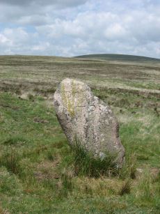
Quintins Man Standing Stone
OS Map: SX 62101 83873
HER: MDV6765
Megalithic Portal: 45860
PMD: Quintins Man
ShortName: SSxQuintinsMan
Butler map: 34.1
Notes: "A cairn. The name implies a standing stone, but there is no knowledge of one in living memory." [worth] See also, Legendary Dartmoor: Dartmoor's Quintin's Man
Nearby sites: SX 62101 83873
Distance: 2.81km
Quintins Man A Ancient Pool
OS Map: SX 62102 83952
HER: MDV27278
ShortName: PO:QuintinsA
Notes: "Previously identified as a prehistoric barrow, survey work in 1995 suggested this to be a natural feature. One of over 40 'sacred' pools identified by Greeves (2019) that may have prehistoric origin. Lies north of the Quintin's Man cairn."
Nearby sites: SX 62102 83952
Distance: 2.73km
Quintins Man B Ancient Pool
OS Map: SX 62053 84056
HER: MDV127217
ShortName: PO:QuintinsB
Notes: "A pool measuring 20 by 16m. One of over 40 such 'sacred' pools identified on Dartmoor that are thought to have potentially been designed during the prehistoric period."
Nearby sites: SX 62053 84056
Distance: 2.63km
Quintins Man C Ancient Pool
OS Map: SX 61972 84365
HER: MDV127218
ShortName: PO:QuintinsC
Notes: "Pool north of Quintin's Man measures 12 by 8m. One of over 40 such 'sacred' pools identified on Dartmoor that are thought to have potentially been designed during the prehistoric period"
Nearby sites: SX 61972 84365
Distance: 2.35km
Shoveldown N.W. 5 Cist
Prehistoric Dartmoor Walks: Dartmoor Site: Shovel Down Ceremonial Complex
OS Map: SX 64389 86247
HER: MDV4394
Megalithic Portal: 45782
PMD: Stonetor Hill
Alternate name: Shoveldown N.W.1 Cist
ShortName: CT:Shovel NW5
Butler map: 37.5.1
Butler Vol 5: p.202 & Fig.145
Grinsell: GID 1
Notes: NB. NGR from PMD is SX64398640. "The remains of a Bronze age cairn and cist which form part of a cairn cemetery on Long Ridge, known locally as Langridge, overlooking the valley of the River North Teign. The cairn has a circular mound which measures 5.2 metres in diameter and 0.5 metres high. The cist measures 0.83 metres square by up to 0.47 metres deep. The capstone, which once covered the cist, now lies 0.7 metres NNW of the cist." Butler Shoveldown N.W.1. - Vol. 2. Map 37.5. (diagram Vol. 5. p.202).
Nearby sites: SX 64389 86247
Distance: 1.93km
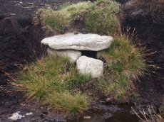
Stonetor Brookhead E. Cist
OS Map: SX 6527 8563
HER: MDV13023
Megalithic Portal: 45807
PMD: Stonetor Brook Head
Alternate name: Stonetor Brookhead E.2 Cist
ShortName: CT:Stonetor E2
Butler map: 37.2.2
Butler Vol 5: p.201 & Fig.144
DPD page: 133
Notes: "A mutilated cist situated amongst peat cuttings on the moderate W slope of shovel Down. Only the N endstone, 0.6m long, remains in situ on the edge of a hollow 1.1m N-S by 0.9m and 0.2m deep. An irregular slab 0.15m thick, probably the disturbed coverstone, lies propped up on the endstone. There is no trace of a covering cairn". Lethbridge diagram p.133 and photo top p.133. Butler Vol. 2. Map 37.2 (diagram Vol 5 p.201).
Nearby sites: SX 6527 8563
Distance: 2.95km
Stonetor Hill Cairn Circle
OS Map: SX 6525 8547
HER: MDV49461
Megalithic Portal: 52273
Alternate name: Stonetor Hill 1 Cairn Circle
ShortName: CC:Stonetor 1
DPD page: 133
Turner: G12
Notes: Dubious site. "Two upright slabs situated in the shallow valley bottom above the headmire of the E arm of the Stonetor Brook. The slabs, 1.2m high, are positioned in line 1.0m apart and lie on the boundary of Gidleigh Parish and the Forest of Dartmoor, now Dartmoor Forest parish. The N face of the E stone has the letters 'GP' (Gidleigh parish). The S face is lichen covered. A deep water filled erosion hollow lies on the N side of these stones". Possibly site listed as Stone Circle G12 by Turner. For a photo of this site, see Boundary stone on Stonetor Hill
Nearby sites: SX 6525 8547
Distance: 2.99km
Stonetor Hill Stone Ring Cairn Circle
OS Map: SX 6520 8536
HER: MDV48856
Megalithic Portal: 3478
Alternate name: Stonetor Hill 3 Stone Ring Cairn Circle
ShortName: RC:Stonetor 3
DPD page: 133
Turner: A3
Notes: Possible pound? "The feature consists of a sub-circular earthern bank 25m in diameter and up to 0.4m in height. It is best preserved on the North side where the bank is well defined, flat topped and has a plan width of about 4.0m On the South side the bank has been spread and flattened but still survives to 0.5m in height as a prominent outward-facing scarp, where the natural ground surface falls away from the enclsure. There is no entrance through the bank."
Nearby sites: SX 6520 8536
Distance: 2.99km
Throwleigh Reported Stone Circle
OS Map: SX 64769 88580
HER: MDV4392
ShortName: SC:Throwleigh
Notes: "Possible circle circa 180 metres north-west of the Buttern Hill circle comprising four or five stones around a fallen standing stone. Recorded by Worth (1894) and apparently seen by the Ordnance Survey in 1950, although the recorder in 1951 could not locate it, this feature has not been confirmed since 1950."
Nearby sites: SX 64769 88580
Distance: 2.98km
White Moor Stone Standing Stone
Prehistoric Dartmoor Walks: Dartmoor Site: Little Hound Tor Stone Circle
OS Map: SX 63359 89491
HER: MDV4391
Megalithic Portal: 10326
PMD: White Moor Stone
ShortName: SS White Moor
Butler map: 40.5
Butler Vol 5: p.53
DPD page: 154
Notes: The White Moor stone lies 160m to the SE of the Little Hound Tor stone circle and it is thought to be contemporary with the circle but probably out of position having been re-erected at some point. It is now a boundary marker.
Nearby sites: SX 63359 89491
Distance: 2.97km
Whitehorse Hill Cist
OS Map: SX 61735 85482
HER: MDV66367
Megalithic Portal: 29778
PMD: White Horse Hill
ShortName: CT Whitehorse
DPD page: 131
Notes: This cist was excavated in August 2011. It featured on an 1892 map by John Chudleigh in An Exploration of Dartmoor's Antiquities. It was re-discovered in 2001 and recently excavated. Carbon dating suggests it is Bronze Age in date. Dates for the top of the cist gives 2800-1890BC and for the bottom of the cist 3650-3100BC. Provisional carbon dates for artifacts suggest the remains are Bronze Age (1900-1500BC). Inside the cist an animal hide bag was found containing cremation remains including a number of artefacts including amber beads (amber would have been imported from overseas), wooden ear studs, a delicate bracelet studded with tin beads, a textile fragment with detailed leather fringing and a unique coiled bag.
There is some good coverage on the Legendary Dartmoor website, see: Whitehorse Kist 1, Whitehorse Kist 2 and Whitehorse Kist 3.
See also DNPA: Update on Whitehorse Hill Cist excavation and Dartmoor tomb treasure horde uncovered by archaeologists. Not listed in Butler - relevant map of area is Vol. 2. Map 41. Lethbridge pp.131-132
Nearby sites: SX 61735 85482
Distance: 1.40km
Whitehorse Hill Reported Stone Circle
OS Map: SX 62208 84940
HER: MDV130871
ShortName: SC:Whitehorse
Notes: "Possible features stone circle and row noted by Hemery (1983), though unconfirmed. Visited with DNPA archaeologist in April 2021. In a very ruinous condition with vegetation covering the majority of the ?stone row."
Nearby sites: SX 62208 84940
Distance: 1.73km
Wild Tor Reported Cairn
OS Map: SX 62218 87124
HER: MDV107564
ShortName: CN-WildTor
Notes: Photo by Steve Granger and reproduced here with his kind permission (copyright remains with Steve). This site is clearly not a prehistoric cairn but is of interest as a reported cairn. Eric Hemery in High Dartmoor (pp.824-5) states "approximately opposite the centre of the south 'bulb' of Bow Combe hour-glass, is a ruined cairn om a square base where a path branches right from the crest and descends the east flank of the ridge towards Gallavan Down. Not far from the cairn are the remains of two shelters, one circular, the other oval. The first may have been a shepherd's shelter, and the latter, the larger of the two a peat-cutter's house." The HER record 107564 reports the presence of many "mielner" platform's in this area and this could be the origins of this structure although most are considered to be round peat structures unlike this structure which has a square stone base. There was a peat charcoal industry in this area. The HER quotes Phil Newman: "The largest and clearest cluster of 'meiler' platforms on northern Dartmoor. At least 25 'meiler' platforms in an area completely denuded of peat. Located 737 metres south of Wild Tor. First recorded by Woolner in the 1960s. The existence of a peat charcoal industry on Dartmoor has its origins in the 12th century or earlier. Peat charcoal was used for iron smithing and tin smelting from the Medieval period until the 19th century. It provided a major income for Dartmoor residents. Large areas of suitable peat would have been harvested and dried before being burned to produce charcoal. The platforms onto which these 'meilers' were constructed are the only field evidence for the process. 'Meiler' platforms comprise raised, usually circular, earthworks with level tops. Although similar to peat drying platforms they lack the peripheral drainage ditch and charcoal samples confirm their use. The level platform was prepared with circular tiers of dried peat bricks with horizontal vents to admit a controlled air flow. Sites for peat charcoal burning were always on raised ground within areas of visible turf cutting and, on Dartmoor, between altitudes 465 metres and 545 metres OD. The cutting was often extensive and sometimes areas were denuded of peat. The platforms recorded so far are mostly organised in clusters at single locations suggesting that burning was undertaken at regional hubs." Note on grid reference: The HER gives SX 622 870 for the group of meilers - the grid reference used here is that of a squarish object that can be seen on Google satellite which is presumed to be the structure in the photo. See also Dartmoor Archive: Meiler near Wild Tor
Nearby sites: SX 62218 87124
Distance: 0.55km