
Watern Tor Reported Cairn
Database entries
OS Map: SX 6291 8682
OS Source: HER
Butler OS: SX62878688
HER: MDV4390
Alternate name: Watern Tor
Short Name: CN:WaternTor 2
Butler map: 41.4
Grinsell: LYDFORD 7
Exist: Yes
Record: Unique
Record Source: Butler
Hut Class: No
Cairn Class: Yes
Dimensions (m): 4.5 x 0.4
Lidar: SX 6291 8682
Guide Map: 11
Nearest Bus Stop (Minor): Wonson Telephone Box (6.8 km) [Route: 670]
Nearest Bus Stop (Major): Ramsley (6.7 km) [Route: 670,671,6A]
Nearby sites: SX 6291 8682
Notes
HER: A possible prehistoric cairn situated on flat-covered ground 15 metres north of Watern Tor. This irregular feature measures 5.0 metres north to south by 5.5 metres and stands a maximum of 0.65 metres high. A large slab, probably a natural outcrop, protrudes through the turf covering of the mound on the north eastern side and it would seem that smaller stones have accumulated behind it to form a cairn. There is no evidence to support the presence of a cist and the monument does not conform to the typical description of a prehistoric cairn.HER: The monument includes a round cairn situated on high ground between the Thirlstone and Watern Tor. The cairn survives as a flat topped, oval shaped mound measuring 5.5 metres long by 5 metres wide and 0.7 metres high. A large granite slab denotes the north eastern edge of the mound.
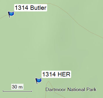
The Butler NGR is around 70m to the north of the HER NGR used for this record.
References
These are selected references with an emphasis on out of copyright sources linked as PDFs. For more detailed references try any linked HER or PMD record above.
- Butler, Jeremy, Dartmoor Atlas of Antiquities, vol.2: The North, (1991)
- Grinsell, L.V., Dartmoor Barrows, Devon Archaeological Society Proceedings No.36 (1978)
- Newman, Phil, Archaeological Sites within Okehampton Training Area, Southwest Landscape Investigations (2014)