
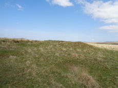
Prehistoric sites within 2km of SX 60500 69900
Guidance for walkers: The monuments featured in this database are archaeological treasures and need to be protected and preserved - please do not disturb any sites. Please check access and firing times before visiting sites, not all sites listed are on open access land. Firing ranges and boundaries of open access areas are marked on the OL28 OS Dartmoor Explorer map. Please stick to the country code and consider giving support to the numerous agencies that help to keep Dartmoor a fabulous natural and historic environment!
About the database listings: In all listings clicking on the photo or the site name will open a page for the site with a larger photo and further details from the database. The database now has over 6680 records covering nearly all publicly listed sites on Dartmoor including around 4800 round houses. This level of detail is of interest to archaeologists but tends to swamp listings of sites more likely to be of interest for walkers. For this reason, the listings default to around 550 core sites only. These are the stone circles, stone rows and the ring cairns listed by Turner. The default search radius is 2 km. The controls below the map can be used to start a new search by entering a 6- or 8-digit reference (without the prefix "SX"). The search radius can be specified and you can add incremental Display layers of detail on top of the core sites. If using a more detailed layer you will need to decrease the search radius to avoid getting hundreds of search results.
- Core sites Default listing of core sites consisting of stone circles & rows and some of the major ring cairns.
- Plus cairns adds approx. 1000 cairns and other minor sites not included in the core listings but excluding round houses.
- Plus round houses adds approx. 4800 round houses.
- Plus non-sites adds in the records for sites that no longer exist or are not prehistoric sites.
- Plus duplicates adds records excluded as duplicates. Those maybe duplicate records in external listings (e.g. the Historic Environment Records). For example, some sites have been identified as cairns in some listings and interpreted as round houses in other listings and both records appear.
These listings have incorporated, matched up and merged all of the records from all of the major archaeological listings including: Worth, Grinsell, Turner, Butler, Bill Radcliffe, Sandy Gerrard, Megalithic Portal, the National Monument Records and the Historic Environment Records. The author would like to thank Bill, Sandy, the lovely people both at Megalithic Portal (especially Anne Tate who did an amazing job to link listings) and at ACE Archaeology for collaborative work over the years to synchronise and correct listings across the various websites which now interlink. A culmination of years of work the final merger of cairn records took 3 months of cross referencing in 2017 the result being a snapshot of the records at that time. This data has in turn been refined since by field work and research. The round house data was supplied by Sandy Gerrard. Grid references are in order of accuracy: from Google Earth satellite, if visible and found, from a Garmin GPS reading, if visited by the author and from the literature otherwise. Individual site pages will state the source of the grid reference and provide satellite imagery. If a site listing lacks a photo it has not yet been visited by the author in which case the grid reference is from the literature.
Currently the database only includes sites which can be represented by a grid reference. Reaves are not included as they require GIS shape technology which is beyond the current capability of this system. To see the sources for the records, look at the tables on the resources menu. The database listings can also be viewed on a Google map and downloaded as GPS datasets for Garmin devices.
Corrections, or any feedback or suggestions are very welcome, email: info@dartmoorwalks.org.uk.
NOTE: Clicking on the icons for each monument in the map will give the name of the site. You can zoom in and out and drag the map around.
List of sites within 2km of SX 60500 69900

Eylesbarrow 2 Cairn
OS Map: SX 60001 68627
HER: MDV132199
ShortName: CN Eylesbarr 2
Butler map: 47.15.2
Notes: Butler: "Not unusually smaller cairns share the peaks withhe giants and two can be found east of th larger cairn (HER 4014) approximately in line with the reave. Recently added to HER. Thanks to Steve Szypko for assistance locating this feature on 31/10/24.
Nearby sites: SX 60001 68627
Distance: 1.37km

Eylesbarrow 3 Cairn
OS Map: SX 60061 68646
HER: MDV132200
ShortName: CN?Eylesbarr 3
Butler map: 47.15.3
Notes: Butler: "Not unusually smaller cairns share the peaks withhe giants and two can be found east of th larger cairn (HER 4014) approcimately in line with the reave. Recently added to HER. Thanks to Steve Szypko for assistance locating this feature on 31/10/24.
Nearby sites: SX 60061 68646
Distance: 1.33km
Down Tor Cairn
OS Map: SX 58642 69315
HER: MDV3440
Megalithic Portal: 27903
Alternate name: Hingston Hill Summit 1 Cairn
ShortName: CN Hingston 1
Butler map: 47.12.1
Grinsell: WAL 30
Notes: "cairn mound measures 15.5m in diam and stands up to 1.5m high. A t-shaped trench cutting into the centre of the mound suggests partial early excavation, though the results of the investigation are not known. This cairn forms part of a ritual complex of monuments including 3 cairns, a stone alignment and enclosure". Approx 70 m NW of the cairn circle at the end of the Down Tor stone row.
Nearby sites: SX 58642 69315
Distance: 1.95km
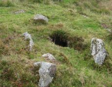
Foxtor Mires W. Platform Cairn Circle and Cist
OS Map: SX 60780 70484
HER: MDV12967
Megalithic Portal: 24008
PMD: Whiteworks
ShortName: CT FoxTorMireW
Butler map: 64.6
DPD page: 97
Turner: E19
Notes: "Seven large orthostats of the retaining circle remain in situ on the south and south-east side (see plan). The cist is entirely below ground level to a depth of 0.7m and measures 1.0m by 0.6m. The two endstones and two sidestones are visible; a stone which may be the coverstone lies on the ground to one side". Lethbridge diagram p.93, photos bottom p.97. Butler Foxtor Mires W. - Vol. 4. Map 64.6 (diagram p.222). Cairn with kerb circle, visible on N, E & W sides, with a central cist.
Nearby sites: SX 60780 70484
Distance: 0.65km
Goldsmith's Cross E.2. Ring Setting Cairn and Cist
OS Map: SX 61804 70321
HER: MDV6342
Megalithic Portal: 42707
PMD: Fox Tor Mires cairn
Alternate name: Goldsmith's Cross E.2 Ring Setting Cairn and Cist
ShortName: CT GoldsmithE2
Butler map: 64.5.2
DPD page: 95
Grinsell: LYD 95
Turner: D23
Notes: "West end stone of cist leans slightly inwards, otherwise a perfect cist measuring 0.75m NW-SE by 0.5m wide by 0.4m deep. Retaining circle of 7 stones averaging 0.4m high. No coverstone or barrow". Lethbridge diagram p.93, photo bottom right p.95 and on p.96. Turner D23 (Fox Tor Mire) - Proc Devon Arch Soc 48 (diagram p.45). Butler Goldsmith's Cross E. 2 - Vol. 4. Map 64.5 (Cairn 2 - diagram p.221).
Nearby sites: SX 61804 70321
Distance: 1.37km
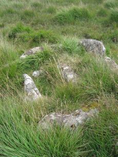
Goldsmith's Cross S. Cist
OS Map: SX 61684 69872
HER: MDV5081
Megalithic Portal: 42708
PMD: Fox Tor Mires S 5
Alternate name: Goldsmiths Cross S. Cist
ShortName: CT Goldsmith S
Butler map: 64.5
DPD page: 97
Grinsell: LYD 100
Barrow Report: 46 56
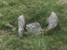
Notes: "The remains of a cist lie some 80m E of the Whealam stream works at SX 61666985, on gently sloping ground 50m S of the newtake wall. The remains consist of four granite slabs set into the ground, forming three sides of a trapezoidal structure. It measures 1.2m long and a maximum of 0.85m wide. The long side, unusually formed of two granite slabs, is oriented NW to SE. The maximum height which the stones protrude above the ground is 0.2m. The SW side of the structure is missing; there are no traces of a capstone or cairn".
Nearby sites: SX 61684 69872
Distance: 1.18km
Goldsmiths Cross E.1. Cist
OS Map: SX 61871 70395
HER: MDV61775
Megalithic Portal: 45806
PMD: Fox Tor Mires E.
Alternate name: Goldsmiths Cross E.1 Cist
ShortName: CT:GoldsmithE1
Butler map: 64.5.1
Notes: "Clear remains of cairn with cist. One side and one end stone of cist are in place. The western side stone may be beneath the turf, but the southern end stone and cover stone are missing. The internal dimensions of the cist are approximately 0.53 x 0.58 x 0.45 meters (1 foot 9 inches x 1 foot 11 inches x 1 foot 6 inches). Immediately around cist there was a backing of comparatively large flat stones.". Butler Goldsmith's Cross E. 1. Vol. 4. Map 64.5 (Cairn 1 - diagram p.221). There is no NMR for this site. There is an HER entry MDV61775 which matches precisely with the OS reference given by Butler. Butler describes: "The mound 0.1m high at best surrounds a slightly wedge-shaped cist of which only the sides, one composed of two stones, and an end are visible. The missing slab is probably buried in place".
Nearby sites: SX 61871 70395
Distance: 1.46km
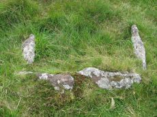
Goldsmiths Cross E.3. Cist
OS Map: SX 61741 70204
HER: MDV6343
Megalithic Portal: 45748
PMD: Goldsmith's Cross
Alternate name: Goldsmiths Cross E.3 Cist
ShortName: CT:GoldsmithE3
Butler map: 64.5.3
DPD page: 95
Grinsell: LYD 94
Barrow Report: 58
Notes: "The NW sidestone, 0.8m long by 0.2m wide and the NE endstone 0.6m long, 0.15m wide are the only recognisable cist stones though it is possible that the SW side was formed by the two small slabs still visible and depicted by Worth. There is no coverstone". Lethbridge diagram p.93, photo bottom left p.95. Butler Goldsmith's Cross E.3. - Vol. 4. Map 64.5 (Cairn 3 - diagram p.221).
Nearby sites: SX 61741 70204
Distance: 1.28km
Great Gnat's Head Cist
OS Map: SX 61174 68034
HER: MDV5091
Megalithic Portal: 45675
PMD: Great Gnat's Head
Alternate name: Great Gnats Head 1 Cist
ShortName: CT GreatGnats1
Butler map: 50.5.1
DPD page: 42
Grinsell: SHA 1
Barrow Report: 20
Notes: "Cist measures a maximum 1.0m long by 0.70m internally and 0.7m deep. Two side slabs and a fallen end slab are extant. There is no trace of a cover stone.". Lethbridge (near Abbot's Way cist) photo and diagram p.42 Butler Great Gnat's Head 1 - Vol. 3. Map 50.5 (diagram p.155).
Nearby sites: SX 61174 68034
Distance: 1.98km
Hingston Hill Enclosed Settlement
OS Map: SX 59118 69477
HER: MDV3435
Megalithic Portal: 27901
ShortName: ES Down Tor
Butler map: 47.7
DPD page: 29
Notes: "Hingston hill pound, east of down tor, is a circular enclosure whose wall consists of large stones. Entrance is marked by a slab like stone which extends through the thickness of a wall. About 100m from the pound in a direction 15 s of e lies the centre of a cairn, c.18m in diameter at the base. The down tor stone row points to this cairn (Worth)". Lethbridge pp.27-29, diagram p.27. Listed as Narrator Brookhead Enclosure on Megalithic Portal.
Nearby sites: SX 59118 69477
Distance: 1.45km

Hingston Hill Chambered Cairn
Prehistoric Dartmoor Walks: Dartmoor Site: Down Tor Stone Row and Cairn Circle
OS Map: SX 59201 69453
HER: MDV3375
Megalithic Portal: 27900
PMD: Narrator Brookhead N.
Alternate name: Narrator Brookhead 1 Chambered Cairn
ShortName: CN Narrator 1
Butler map: 47.7.1
Butler Vol 5: p.158
Grinsell: WAL 32
Notes: The large cairn to NW of Down Tor (Hingston Hill) stone row has been claimed to contain a cist or "elements of chambering" (Burnard via PMD). A stony round cairn located on the flatish sadle of Hingston Hill. The cairn mound measures 17 metres in diameter and stands up to 1.5 metres high. A hollow in the centre of the mound measures 4 metres long, 3 metres wide and 1.2 metres deep, and is probably the result of partial robbing or early excavation. The edges of the mound are steep-sided, indicating the existence of a kerb, which now survives mainly as a buried feature. A quarry ditch surrounds the mound, visible as a 1.5 metre wide band of rushes on the northern side of the mound, the result of increased moisture in the buried ditch. This cairn is in direct line with the two terminal stones at either end of a stone alignment to the south-west.
Nearby sites: SX 59201 69453
Distance: 1.37km
Hingston Hill (Down Tor) Standing Stone
Prehistoric Dartmoor Walks: Dartmoor Site: Down Tor Stone Row and Cairn Circle
OS Map: SX 58702 69276
HER: MDV3502
Megalithic Portal: 1901
PMD: Down Tor Standing Stone
ShortName: SS Down Tor
Butler map: 47.12
DPD page: 29
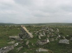
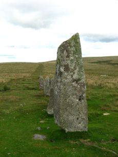
Notes: "A stone alignment and cairn, situated on a saddle 620 metres east of Down Tor. The alignment is orientated east-north-east to west-south-west, running for 316 metres and containing at least 174 stones, with the tallest at either end. The westernmost stone stands 2.8 metre high, the easternmost stone stands 1.6 metres high, and the remainder vary between 1 metre and 0.2 metres in height. The westernmost stone, and an unknown number of others, were re-erected by Baring-Gould and Burnard in 1890."
Nearby sites: SX 58702 69276
Distance: 1.90km
Hingston Hill (Down Tor) Stone Row
Prehistoric Dartmoor Walks: Dartmoor Site: Down Tor Stone Row and Cairn Circle
OS Map: SX 58697 69267
HER: MDV3502
Megalithic Portal: 1901
The Stone Rows of GB: Hingston Hill
PMD: Down Tor Stone Row
Alternate name: Hingston Hill Stone Row
ShortName: SR Down Tor
Butler map: 47.12
DPD page: 28
Barrow Report: 66
Notes: "A stone alignment and cairn, situated on a saddle 620 metres east of Down Tor. The alignment is orientated east-north-east to west-south-west, running for 316 metres and containing at least 174 stones, with the tallest at either end."
Nearby sites: SX 58697 69267
Distance: 1.91km
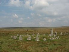
Hingston Hill (Down Tor) Encircled Cairn
Prehistoric Dartmoor Walks: Dartmoor Site: Down Tor Stone Row and Cairn Circle
OS Map: SX 58693 69270
HER: MDV3439
Megalithic Portal: 541
PMD: Down Tor Cairn Circle
Alternate name: Hingston Hill stone row Encircled Cairn
ShortName: EC Down Tor
Butler map: 47.12
DPD page: 28
Grinsell: WAL 31
Turner: F6
Barrow Report: 14
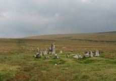
Notes: "The cairn circle consists of 26 upright stones and possibly two more now recumbent; it has an internal diameter of 11.5m. Within the circle is a cairn of 8.5m diameter and 0.6m height with a small depression in the centre which may be the site of a cist". Lethbridge pp.27-29, diagram p.27.
Nearby sites: SX 58693 69270
Distance: 1.91km
Newleycombe Lake Head Enclosed Settlement
OS Map: SX 5959 6985
HER: MDV3427
ShortName: ES:Newleycombe
Notes: HER: Agglomerate enclosure straddling a shallow north-facing valley overlooking Newleycombe Lake. Composed of three conjoined enclosures defined by a partly faced rubble wall measuring 1.5 metres wide and up to 0.5 metres high. Interior of the southern enclosure measures 80 metres north-south by 90 metres east-west and the north-west enclosure, which is sub-triangular in shape, measures 44 metres north-south by 37 metres east-west. The original dimensions of the third enclosure are no longer discernible following later tin stream working which has removed part of its extent. There are three gaps in the boundary which may represent original entrances, though it is possible that they may be the result of limited post-medieval stone robbing.
Nearby sites: SX 5959 6985
Distance: 0.91km