
Prehistoric sites within 3km of SX 59500 79600
Guidance for walkers: The monuments featured in this database are archaeological treasures and need to be protected and preserved - please do not disturb any sites. Please check access and firing times before visiting sites, not all sites listed are on open access land. Firing ranges and boundaries of open access areas are marked on the OL28 OS Dartmoor Explorer map. Please stick to the country code and consider giving support to the numerous agencies that help to keep Dartmoor a fabulous natural and historic environment!
About the database listings: In all listings clicking on the photo or the site name will open a page for the site with a larger photo and further details from the database. The database now has over 6680 records covering nearly all publicly listed sites on Dartmoor including around 4800 round houses. This level of detail is of interest to archaeologists but tends to swamp listings of sites more likely to be of interest for walkers. For this reason, the listings default to around 550 core sites only. These are the stone circles, stone rows and the ring cairns listed by Turner. The default search radius is 2 km. The controls below the map can be used to start a new search by entering a 6- or 8-digit reference (without the prefix "SX"). The search radius can be specified and you can add incremental Display layers of detail on top of the core sites. If using a more detailed layer you will need to decrease the search radius to avoid getting hundreds of search results.
- Core sites Default listing of core sites consisting of stone circles & rows and some of the major ring cairns.
- Plus cairns adds approx. 1000 cairns and other minor sites not included in the core listings but excluding round houses.
- Plus round houses adds approx. 4800 round houses.
- Plus non-sites adds in the records for sites that no longer exist or are not prehistoric sites.
- Plus duplicates adds records excluded as duplicates. Those maybe duplicate records in external listings (e.g. the Historic Environment Records). For example, some sites have been identified as cairns in some listings and interpreted as round houses in other listings and both records appear.
These listings have incorporated, matched up and merged all of the records from all of the major archaeological listings including: Worth, Grinsell, Turner, Butler, Bill Radcliffe, Sandy Gerrard, Megalithic Portal, the National Monument Records and the Historic Environment Records. The author would like to thank Bill, Sandy, the lovely people both at Megalithic Portal (especially Anne Tate who did an amazing job to link listings) and at ACE Archaeology for collaborative work over the years to synchronise and correct listings across the various websites which now interlink. A culmination of years of work the final merger of cairn records took 3 months of cross referencing in 2017 the result being a snapshot of the records at that time. This data has in turn been refined since by field work and research. The round house data was supplied by Sandy Gerrard. Grid references are in order of accuracy: from Google Earth satellite, if visible and found, from a Garmin GPS reading, if visited by the author and from the literature otherwise. Individual site pages will state the source of the grid reference and provide satellite imagery. If a site listing lacks a photo it has not yet been visited by the author in which case the grid reference is from the literature.
Currently the database only includes sites which can be represented by a grid reference. Reaves are not included as they require GIS shape technology which is beyond the current capability of this system. To see the sources for the records, look at the tables on the resources menu. The database listings can also be viewed on a Google map and downloaded as GPS datasets for Garmin devices.
Corrections, or any feedback or suggestions are very welcome, email: info@dartmoorwalks.org.uk.
NOTE: Clicking on the icons for each monument in the map will give the name of the site. You can zoom in and out and drag the map around.
List of sites within 3km of SX 59500 79600
Conies Down stone row (natural outcrop) Reported Cairn
OS Map: SX 586 789
HER: MDV4592
ShortName: CNxConies Do2
Grinsell: LYD 33
Notes: Natural outcrop which is probably the small cairn described by Crossing. Probably duplicate of Conies Down (alleged) but the "roughly" NGR give by Grinsell does not match.
Nearby sites: SX 586 789
Distance: 1.14km
Higher White Tor (SW of) Reported Cairn
OS Map: SX 6163 7825
HER: MDV5957
ShortName: CN?Higher Wh1
Grinsell: LYD 41b
Notes: natural? round barrow between longford tor and higher white tor. A very large barrow 1.3m high with a diameter of 30m under gorse and heather. No sign of ditch or kerb exist and there is no indication of an earlier disturbance. The monument is in a classic position commanding a fine view of the cherry brook valley.
Nearby sites: SX 6163 7825
Distance: 2.52km
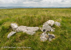
Devil's Tor 2 Reported Cairn
OS Map: SX 59630 79497
ShortName: CN Devils Tor2
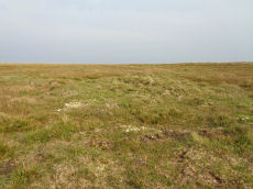
Notes: The author found this walking south from the Beardown man standing stone on 15/09/20. It is quite clearly a cairn although whether or not it is prehistoric is another matter. There does not seem to be much evidence of clearance taking place in this area which would suggest a prehistoric cairn. There are no records in the HER except to a site further south, see siteid=4005 Devil's Tor. The cairn is approx 4-5 metres across as judged by eye - no precise measurement was taken. The HER record MDV4217 relates to a cairn reported by Worth in 1948 - maybe this is it. The site further south which is identified in the HER record is described as not being a cairn and this author would agree. The NMR record SX 57 NE 2 refers to confusion to two reported sites south of Beardown Man - but neither grid reference is satisfactorly close although likely that is a problem with the grid references.
Nearby sites: SX 59630 79497
Distance: 0.17km
Conies Down 3 Cairn
OS Map: SX 5917 7924
HER: MDV48268
ShortName: CN:Conies Do3
Nearby sites: SX 5917 7924
Distance: 0.49km
Longaford Tor Round House
OS Map: SX 61334 77325
HER: MDV105675
ShortName: HT:Longafd1
Nearby sites: SX 61334 77325
Distance: 2.92km
Longaford Tor Round House
OS Map: SX 61329 77303
HER: MDV105675
ShortName: HT:Longafd2
Nearby sites: SX 61329 77303
Distance: 2.94km
Longaford Tor Round House
OS Map: SX 6117 7771
HER: MDV105675
ShortName: HT:Longafd5
Nearby sites: SX 6117 7771
Distance: 2.52km
Longaford Tor Round House
OS Map: SX 61218 77718
HER: MDV105675
ShortName: HT:Longafd6
Nearby sites: SX 61218 77718
Distance: 2.55km
Longaford Tor Round House
OS Map: SX 61329 77356
HER: MDV105675
ShortName: HT:Longafd7
Nearby sites: SX 61329 77356
Distance: 2.89km
Longaford Tor Round House
OS Map: SX 61329 77418
HER: MDV105675
ShortName: HT:Longafd9
Nearby sites: SX 61329 77418
Distance: 2.85km
Longaford Tor Round House
OS Map: SX 61324 77380
HER: MDV105675
ShortName: HT:Longafd10
Nearby sites: SX 61324 77380
Distance: 2.87km
Longaford Tor Round House
OS Map: SX 61328 77479
HER: MDV105675
ShortName: HT:Longafd13
Nearby sites: SX 61328 77479
Distance: 2.80km
Longaford Tor Round House
OS Map: SX 61324 77294
HER: MDV105675
ShortName: HT:Longafd14
Nearby sites: SX 61324 77294
Distance: 2.94km
Longaford Tor Round House
OS Map: SX 61329 77256
HER: MDV105675
ShortName: HT:Longafd15
Nearby sites: SX 61329 77256
Distance: 2.97km
Longaford Tor Round House
OS Map: SX 61324 77221
HER: MDV105675
ShortName: HT:Longafd16
Nearby sites: SX 61324 77221
Distance: 3.00km
Longaford Tor Round House
OS Map: SX 61329 77356
HER: MDV105675
ShortName: HT:Longafd18
Nearby sites: SX 61329 77356
Distance: 2.89km
Longaford Tor Round House
OS Map: SX 61225 77540
HER: MDV105675
ShortName: HT:Longafd20
Nearby sites: SX 61225 77540
Distance: 2.69km
Longaford Tor Round House
OS Map: SX 61217 77571
HER: MDV105675
ShortName: HT:Longafd23
Nearby sites: SX 61217 77571
Distance: 2.66km
Longaford Tor Round House
OS Map: SX 61323 77241
HER: MDV105675
ShortName: HT:Longafd24
Nearby sites: SX 61323 77241
Distance: 2.98km
Longaford Tor Round House
OS Map: SX 6111 7786
HER: MDV105675
ShortName: HT:Longafd25
Nearby sites: SX 6111 7786
Distance: 2.37km
Longaford Tor Round House
OS Map: SX 61339 77278
HER: MDV105675
ShortName: HT:Longafd26
Nearby sites: SX 61339 77278
Distance: 2.96km
Longaford Tor Round House
OS Map: SX 61374 77302
HER: MDV105675
ShortName: HT:Longafd30
Nearby sites: SX 61374 77302
Distance: 2.97km
Longaford Tor Round House
OS Map: SX 61376 77276
HER: MDV105675
ShortName: HT:Longafd31
Nearby sites: SX 61376 77276
Distance: 2.99km
Longaford Tor Round House
OS Map: SX 61381 77324
HER: MDV105675
ShortName: HT:Longafd34
Nearby sites: SX 61381 77324
Distance: 2.95km
Longaford Tor Round House
OS Map: SX 61397 77281
HER: MDV105675
ShortName: HT:Longafd38
Nearby sites: SX 61397 77281
Distance: 3.00km
Rough Tor Cairn
OS Map: SX 6088 8017
HER: MDV61965
ShortName: CN:Rough Tor
Nearby sites: SX 6088 8017
Distance: 1.49km
Longaford Tor Round House
OS Map: SX 61379 77300
HER: MDV105675
ShortName: HT:Longafd43
Nearby sites: SX 61379 77300
Distance: 2.97km
Longaford Tor Round House
OS Map: SX 60803 78077
HER: MDV52781
ShortName: HT:Longafd44
Nearby sites: SX 60803 78077
Distance: 2.00km
Longaford Tor Round House
OS Map: SX 6114 7785
HER: MDV105675
ShortName: HT:Longafd45
Nearby sites: SX 6114 7785
Distance: 2.40km
Longaford Tor Round House
OS Map: SX 61344 77362
HER: MDV105675
ShortName: HT:Longafd47
Nearby sites: SX 61344 77362
Distance: 2.90km
Longaford Tor Round House
OS Map: SX 61351 77489
HER: MDV105675
ShortName: HT:Longafd48
Nearby sites: SX 61351 77489
Distance: 2.81km
Longaford Tor Round House
OS Map: SX 6117 7770
HER: MDV105675
ShortName: HT:Longafd54
Nearby sites: SX 6117 7770
Distance: 2.53km
Longaford Tor Round House
OS Map: SX 61251 77510
HER: MDV105675
ShortName: HT:Longafd56
Nearby sites: SX 61251 77510
Distance: 2.73km
Longaford Tor Round House
OS Map: SX 6118 7771
HER: MDV105675
ShortName: HT:Longafd57
Nearby sites: SX 6118 7771
Distance: 2.53km
Longaford Tor Round House
OS Map: SX 61305 77525
HER: MDV105675
ShortName: HT:Longafd58
Nearby sites: SX 61305 77525
Distance: 2.75km
Longaford Tor Round House
OS Map: SX 61199 77822
HER: MDV105675
ShortName: HT:Longafd60
Nearby sites: SX 61199 77822
Distance: 2.46km
Longaford Tor Round House
OS Map: SX 61349 77259
HER: MDV105675
ShortName: HT:Longafd62
Nearby sites: SX 61349 77259
Distance: 2.98km
Spriddle Lake Reported Cairn
OS Map: SX 5768 7968
HER: MDV68891
ShortName: CN?Spriddle 1
Nearby sites: SX 5768 7968
Distance: 1.82km
Longaford Tor Round House
OS Map: SX 6127 7750
HER: MDV105675
ShortName: HT:Longafd63
Nearby sites: SX 6127 7750
Distance: 2.75km
Longaford Tor Round House
OS Map: SX 61307 77333
HER: MDV105675
ShortName: HT:Longafd64
Nearby sites: SX 61307 77333
Distance: 2.90km
Longaford Tor Round House
OS Map: SX 61305 77439
HER: MDV105675
ShortName: HT:Longafd65
Nearby sites: SX 61305 77439
Distance: 2.82km
Longaford Tor Round House
OS Map: SX 61237 77680
HER: MDV105675
ShortName: HT:Longafd67
Nearby sites: SX 61237 77680
Distance: 2.59km
Longaford Tor Round House
OS Map: SX 61234 77565
HER: MDV105675
ShortName: HT:Longafd69
Nearby sites: SX 61234 77565
Distance: 2.67km
Broad Hole S. Reported Cairn
OS Map: SX 5915 7824
HER: MDV49705
ShortName: CN:Broad Hol1
Butler map: 29.14
Notes: HER has this listed as a hut circle. Butler describes as a cairn and NMR suggests possible capstone of a cist.
Nearby sites: SX 5915 7824
Distance: 1.40km
Longaford Tor Round House
OS Map: SX 61259 77537
HER: MDV105675
ShortName: HT:Longafd70
Nearby sites: SX 61259 77537
Distance: 2.71km
Longaford Tor Round House
OS Map: SX 61259 77517
HER: MDV105675
ShortName: HT:Longafd71
Nearby sites: SX 61259 77517
Distance: 2.73km
Longaford Tor Round House
OS Map: SX 6126 7742
HER: MDV105675
ShortName: HT:Longafd72
Nearby sites: SX 6126 7742
Distance: 2.80km
Longaford Tor Round House
OS Map: SX 61255 77431
HER: MDV105675
ShortName: HT:Longafd74
Nearby sites: SX 61255 77431
Distance: 2.79km
Longaford Tor Round House
OS Map: SX 61242 77585
HER: MDV105675
ShortName: HT:Longafd75
Nearby sites: SX 61242 77585
Distance: 2.66km
Longaford Tor Round House
OS Map: SX 61270 77501
HER: MDV105675
ShortName: HT:Longafd77
Nearby sites: SX 61270 77501
Distance: 2.75km
Conies Down Stone Row Cairn
OS Map: SX 5859 7905
HER: MDV4592
ShortName: CN:Conies Do1
Butler map: 30.11
Nearby sites: SX 5859 7905
Distance: 1.06km
Longaford Tor Round House
OS Map: SX 61238 77513
HER: MDV105675
ShortName: HT:Longafd78
Nearby sites: SX 61238 77513
Distance: 2.72km
Broad Hole N Round House
OS Map: SX 59202 78857
HER: MDV4589
ShortName: HT:Broad Hol1
Nearby sites: SX 59202 78857
Distance: 0.80km
Longaford Tor Round House
OS Map: SX 61283 77519
HER: MDV105675
ShortName: HT:Longafd79
Nearby sites: SX 61283 77519
Distance: 2.74km
Broad Hole N Round House
OS Map: SX 59200 78768
HER: MDV4589
ShortName: HT:Broad Hol2
Nearby sites: SX 59200 78768
Distance: 0.88km
Longaford Tor Round House
OS Map: SX 61285 77516
HER: MDV105675
ShortName: HT:Longafd80
Nearby sites: SX 61285 77516
Distance: 2.74km
White Barrow Cairn
OS Map: SX 56852 79309
HER: MDV4214
ShortName: CN:White Bar1
Butler map: 30.13
Grinsell: LYD 31
Nearby sites: SX 56852 79309
Distance: 2.66km
Broad Hole N Round House
OS Map: SX 59212 78834
HER: MDV4589
ShortName: HT:Broad Hol3
Nearby sites: SX 59212 78834
Distance: 0.82km
Longaford Tor Round House
OS Map: SX 61287 77464
HER: MDV105675
ShortName: HT:Longafd81
Nearby sites: SX 61287 77464
Distance: 2.78km
Broad Hole N Round House
OS Map: SX 5913 7882
HER: MDV50599
ShortName: HT:Broad Hol4
Nearby sites: SX 5913 7882
Distance: 0.86km
Longaford Tor Round House
OS Map: SX 61299 77396
HER: MDV105675
ShortName: HT:Longafd82
Nearby sites: SX 61299 77396
Distance: 2.84km
Youldon Brookhead Cairn
OS Map: SX 56720 79825
HER: MDV66017
ShortName: CN:Youldon B1
Butler map: 30.15
Nearby sites: SX 56720 79825
Distance: 2.79km
Broad Hole N Round House
OS Map: SX 5911 7889
HER: MDV48274
ShortName: HT:Broad Hol5
Nearby sites: SX 5911 7889
Distance: 0.81km
Longaford Tor Round House
OS Map: SX 61237 77614
HER: MDV105675
ShortName: HT:Longafd83
Nearby sites: SX 61237 77614
Distance: 2.64km
Broad Hole N Round House
OS Map: SX 59179 78777
HER: MDV4589
ShortName: HT:Broad Hol6
Nearby sites: SX 59179 78777
Distance: 0.88km
Longaford Tor Round House
OS Map: SX 61301 77517
HER: MDV105675
ShortName: HT:Longafd84
Nearby sites: SX 61301 77517
Distance: 2.75km
Broad Hole N Round House
OS Map: SX 59194 78802
HER: MDV4589
ShortName: HT:Broad Hol7
Nearby sites: SX 59194 78802
Distance: 0.85km
Longaford Tor Round House
OS Map: SX 613 778
HER: MDV105675
ShortName: HT:Longafd85
Nearby sites: SX 613 778
Distance: 2.55km
Broad Hole N Round House
OS Map: SX 59190 78841
HER: MDV4589
ShortName: HT:Broad Hol8
Nearby sites: SX 59190 78841
Distance: 0.82km
Longaford Tor Round House
OS Map: SX 61290 77461
HER: MDV105675
ShortName: HT:Longafd86
Nearby sites: SX 61290 77461
Distance: 2.79km
Broad Hole S Round House
OS Map: SX 59132 78258
ShortName: HT:Broad Hol9
Nearby sites: SX 59132 78258
Distance: 1.39km
Longaford Tor Round House
OS Map: SX 61260 77421
HER: MDV105675
ShortName: HT:Longafd87
Nearby sites: SX 61260 77421
Distance: 2.80km
Broad Hole S Round House
OS Map: SX 591 783
HER: MDV49703
ShortName: HT:Broad Hol10
Nearby sites: SX 591 783
Distance: 1.36km
Longaford Tor Round House
OS Map: SX 61232 77724
HER: MDV105675
ShortName: HT:Longafd88
Nearby sites: SX 61232 77724
Distance: 2.55km
Broad Hole S Round House
OS Map: SX 59146 78252
ShortName: HT:Broad Hol11
Nearby sites: SX 59146 78252
Distance: 1.39km
Longaford Tor Round House
OS Map: SX 61256 77553
HER: MDV105675
ShortName: HT:Longafd89
Nearby sites: SX 61256 77553
Distance: 2.70km
Broad Hole S Round House
OS Map: SX 5911 7830
HER: MDV49704
ShortName: HT:Broad Hol12
Nearby sites: SX 5911 7830
Distance: 1.36km
Longaford Tor Round House
OS Map: SX 61233 77611
HER: MDV105675
ShortName: HT:Longafd90
Nearby sites: SX 61233 77611
Distance: 2.64km
Broad Hole S Round House
OS Map: SX 59136 78384
HER: MDV49680
ShortName: HT:Broad Hol13
Nearby sites: SX 59136 78384
Distance: 1.27km
Broad Hole S Round House
OS Map: SX 5903 7826
HER: MDV48277
ShortName: HT:Broad Hol14
Nearby sites: SX 5903 7826
Distance: 1.42km
Longaford Tor Round House
OS Map: SX 61319 77460
HER: MDV105675
ShortName: HT:Longafd92
Nearby sites: SX 61319 77460
Distance: 2.81km
Broad Hole S Round House
OS Map: SX 59171 78465
HER: MDV4623
ShortName: HT:Broad Hol15
Nearby sites: SX 59171 78465
Distance: 1.18km
Longaford Tor Round House
OS Map: SX 6125 7751
HER: MDV105675
ShortName: HT:Longafd93
Nearby sites: SX 6125 7751
Distance: 2.73km
Broad Hole S Round House
OS Map: SX 5926 7823
HER: MDV54356
ShortName: HT:Broad Hol16
Nearby sites: SX 5926 7823
Distance: 1.39km
Broad Hole S Round House
OS Map: SX 5908 7829
HER: MDV49705
ShortName: HT:Broad Hol17
Nearby sites: SX 5908 7829
Distance: 1.38km
Longaford Tor Round House
OS Map: SX 6125 7751
HER: MDV105675
ShortName: HT:Longafd95
Nearby sites: SX 6125 7751
Distance: 2.73km
Broad Hole S Round House
OS Map: SX 5909 7831
HER: MDV49702
ShortName: HT:Broad Hol18
Nearby sites: SX 5909 7831
Distance: 1.35km
Longaford Tor Round House
OS Map: SX 61315 77465
HER: MDV105675
ShortName: HT:Longafd96
Nearby sites: SX 61315 77465
Distance: 2.80km
Longaford Tor Round House
OS Map: SX 61259 77698
HER: MDV105675
ShortName: HT:Longafd97
Nearby sites: SX 61259 77698
Distance: 2.59km
Longaford Tor Round House
OS Map: SX 61245 77450
HER: MDV105675
ShortName: HT:Longafd98
Nearby sites: SX 61245 77450
Distance: 2.77km
Longaford Tor Round House
OS Map: SX 61258 77722
HER: MDV105675
ShortName: HT:Longafd99
Nearby sites: SX 61258 77722
Distance: 2.57km
Longaford Tor Round House
OS Map: SX 61246 77727
HER: MDV105675
ShortName: HT:Longafd100
Nearby sites: SX 61246 77727
Distance: 2.56km

Rowter Cairn
OS Map: SX 62346 79968
HER: MDV106844
ShortName: CN Rowter
Nearby sites: SX 62346 79968
Distance: 2.87km
Devil's Tor Reported Cairn
OS Map: SX 59578 79408
HER: MDV4217
ShortName: CN Devil's Tor
Notes: "A low ovoid cairn located in an area of peat cuttings and shell craters on a ridge crest, 250 metres south of Devil's Tor. It is partially obscured by heather and measures 3.1 metres in diameter with a maximum height of 0.4 metres. There are no indications of a kerb or cist and no obvious sign of disturbance. A natural stone pile at SX 59457939 has been erroneously claimed as the feature described by Worth."
Nearby sites: SX 59578 79408
Distance: 0.21km
Conies Down Tor E Round House
OS Map: SX 5907 7932
HER: MDV48266
ShortName: HT:Conies Do1
Nearby sites: SX 5907 7932
Distance: 0.51km
Conies Down Tor E Round House
OS Map: SX 5912 7923
HER: MDV48266
ShortName: HT:Conies Do2
Nearby sites: SX 5912 7923
Distance: 0.53km
Conies Down Tor E Round House
OS Map: SX 5917 7919
HER: MDV48266
ShortName: HT:Conies Do3
Nearby sites: SX 5917 7919
Distance: 0.53km
Conies Down Tor E Round House
OS Map: SX 5912 7942
HER: MDV48266
ShortName: HT:Conies Do4
Nearby sites: SX 5912 7942
Distance: 0.42km
Conies Down Tor E Round House
OS Map: SX 5912 7921
HER: MDV48266
ShortName: HT:Conies Do5
Nearby sites: SX 5912 7921
Distance: 0.54km
Conies Down Tor E Round House
OS Map: SX 5914 7916
HER: MDV48266
ShortName: HT:Conies Do6
Nearby sites: SX 5914 7916
Distance: 0.57km
Conies Down Tor E Round House
OS Map: SX 5914 7915
HER: MDV48266
ShortName: HT:Conies Do7
Nearby sites: SX 5914 7915
Distance: 0.58km
Conies Down Tor E Round House
OS Map: SX 5912 7938
HER: MDV48266
ShortName: HT:Conies Do8
Nearby sites: SX 5912 7938
Distance: 0.44km
Conies Down 4 (alleged) Reported Cist
OS Map: SX 5812 7963
HER: MDV12809
PMD: Spriddle Lake
ShortName: CNxConies Do4
Notes: No cist could be found in this area. At NGR SX 58167968 are several granite blocks which may have been mistaken for a cist. Probably Grinsell Lydford 33 - but NGR given by Grinsell suggests possible different site.
Nearby sites: SX 5812 7963
Distance: 1.38km
Stennen Hill 7 Reported Cist
OS Map: SX 622 786
HER: MDV5969
ShortName: CT:Stennen 7
Grinsell: LYD 50c
Notes: Supposed cist from which human hair found c. 1827. (PDW: Could this be one of the Cherry Brook cists?)
Nearby sites: SX 622 786
Distance: 2.88km
Longaford Tor Reported Cist
OS Map: SX 6134 7785
HER: MDV57379
PMD: Longaford Tor
ShortName: CT?Longaford1
Notes: Cist set against a natural boulder that would have formed the south side stone, a possible end and side stone, with a large slab to north-west that could have been a capstone. Close to track from south of Longford Tor, towards leat take off point. Possible carn to east.
Nearby sites: SX 6134 7785
Distance: 2.54km
Higher White Tor (site of) Reported Cist
OS Map: SX 622 786
HER: MDV5969
PMD: Whiten Tor - Stennen Hill
ShortName: CT?Higher Wh2
Notes: "This site was apparently excavated in 1827, when human hair was found (Grinsell cites Bray), but this site has not been located since this time - site / location not confirmed."
"The cist on east side of Great Whiten Tor, Postbridge" (Higher White Tor at SX 619785) was examined and revealed faint indications of bone ash contained in a pit 1foot 10inches diameter and 1foot 4inches deep. The pit was covered by a flat stone nearly 2 feet square. The coverstone of the cist had been removed to one side. Cannot be located today."
Nearby sites: SX 622 786
Distance: 2.88km
Foxholes Round House
OS Map: SX 6041 7858
HER: MDV28597
ShortName: HT:Foxholes1
Nearby sites: SX 6041 7858
Distance: 1.37km
Rough Tor NE Round House
OS Map: SX 60862 80248
HER: MDV13031
ShortName: HT:Rough Tor1
Nearby sites: SX 60862 80248
Distance: 1.51km
Rough Tor NE Round House
OS Map: SX 60869 80211
HER: MDV13031
ShortName: HT:Rough Tor2
Nearby sites: SX 60869 80211
Distance: 1.50km
Rough Tor NE Round House
OS Map: SX 60851 80225
HER: MDV13031
ShortName: HT:Rough Tor3
Nearby sites: SX 60851 80225
Distance: 1.49km
Rough Tor NE Round House
OS Map: SX 60852 80218
HER: MDV13031
ShortName: HT:Rough Tor4
Nearby sites: SX 60852 80218
Distance: 1.49km
Rough Tor NE Round House
OS Map: SX 60854 80238
HER: MDV13031
ShortName: HT:Rough Tor5
Nearby sites: SX 60854 80238
Distance: 1.50km
Beardown Tors E Round House
OS Map: SX 61007 77651
HER: MDV5851
ShortName: HT:Beardown 15
Nearby sites: SX 61007 77651
Distance: 2.46km
Beardown Tors E Round House
OS Map: SX 60998 77647
HER: MDV5851
ShortName: HT:Beardown 16
Nearby sites: SX 60998 77647
Distance: 2.46km
Beardown Tors E Round House
OS Map: SX 61006 77581
HER: MDV5851
ShortName: HT:Beardown 17
Nearby sites: SX 61006 77581
Distance: 2.52km
Beardown Tors E Round House
OS Map: SX 61035 77587
HER: MDV5851
ShortName: HT:Beardown 18
Nearby sites: SX 61035 77587
Distance: 2.53km
Beardown Tors E Round House
OS Map: SX 60983 77645
HER: MDV5851
ShortName: HT:Beardown 19
Nearby sites: SX 60983 77645
Distance: 2.45km
Beardown Tors E Round House
OS Map: SX 61012 77603
HER: MDV5851
ShortName: HT:Beardown 20
Nearby sites: SX 61012 77603
Distance: 2.50km
Beardown Tors E Round House
OS Map: SX 610 776
HER: MDV5851
ShortName: HT:Beardown 21
Nearby sites: SX 610 776
Distance: 2.50km
Beardown Tors E Round House
OS Map: SX 61026 77556
HER: MDV5851
ShortName: HT:Beardown 22
Nearby sites: SX 61026 77556
Distance: 2.55km
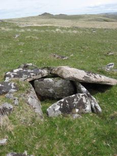
Beardown Platform Cairn Circle and Cist
OS Map: SX 60330 78092
HER: MDV14690
Megalithic Portal: 42853
PMD: Lydford Tor
Alternate name: Lydford Tor E. Platform Cairn Circle and Cist
ShortName: CT Beardown
Butler map: 29.17
Butler Vol 5: p.197 & Fig.140
DPD page: 109
Grinsell: LYD 41a
Turner: E27
Notes: "The cairn, 4.5 metres by 5.6 metres and 0.4 metres high has spread over the remains of a contiguous kerb 4.6 metres in diameter." ... "Three of the cist slabs lean inwards at the top, the fourth, east slab remains upright. The bottom of the cist contains several slabs. The coverstone is visible to the north west partially buried in the cairn." Lethbridge diagram p.107, photo top p.109. Butler Lydford Tor E Vol. 5. Map 29.17 (diagram Vol 5. p.197).
Nearby sites: SX 60330 78092
Distance: 1.72km
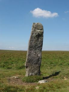
Beardown Man Standing Stone
OS Map: SX 59616 79634
HER: MDV4200
Megalithic Portal: 4144
PMD: Beardown Man Standing Stone
ShortName: SS BeardownMan
Butler map: 29.15
Butler Vol 5: p.220
DPD page: 108
Notes: A Bronze Age standing stone measuring 3.4m high, 1m by 0.4m in section and in good condition. One of the few isolated menhirs on Dartmoor. See also, Legendary Dartmoor: Dartmoor's Beardown Man. Lethbridge diagram p.107, photo p.108.
Nearby sites: SX 59616 79634
Distance: 0.12km
Broad Down Reported Cairn
OS Map: SX 61940 80883
HER: MDV80630
ShortName: CN-BroadDown
Notes: Photo by Peter Brooks and reproduced here with his kind permission (copyright remains with Peter)."Peat cutter's shelter constructed from natural granite slabs 900 meters south of Sandy Hole Pass in an area of extensive peat cutting." Listed on the Modern Antiquarian as a cairn - but clearly a shelter. See: Broad Down Cairn
Nearby sites: SX 61940 80883
Distance: 2.76km
Conies Down Stone Row
OS Map: SX 58591 79076
HER: MDV4592
Megalithic Portal: 1846
The Stone Rows of GB: Conies Down
PMD: Conies Down Stone Row
ShortName: SR ConiesDown
Butler map: 30.11
DPD page: 107
Notes: "The Conies Down stone row is oriented a few degrees west of north-south and is 145m long. Originally a double alignment of stones, only three pairs of upright stones now survive. There are a total of 17 upright and 15 recumbent stones. The average gap between stones is 10m and between the pairs the gap is some 1.4m wide". Lethbridge diagram p.107.
Nearby sites: SX 58591 79076
Distance: 1.05km
Crow Tor Platform Cairn Circle and Cist
OS Map: SX 60531 78683
HER: MDV5938
Megalithic Portal: 45775
PMD: Crow Tor
ShortName: CT Crow Tor
Butler map: 29.18
Butler Vol 5: p.196 & Fig.139
DPD page: 109
Grinsell: LYD 41
Turner: E39
Notes: "A kerbed cairn and cist. The cairn consists of a stony, turf-covered mound, and measures 4.5m in diameter and 0.45m in height. There are traces of a retaining kerb of leaning, granite slabs to the northeast and south. The cist is set slightly to the north of the centre of the cairn. It is trapezoidal in shape, and measures 0.65m and 0.95m in length, 0.8m in width, and 0.5m in depth. The cover-stone, which is 0.9m long, 0.5m wide and 0.2m thick, is displaced and lies just to the south east of the cist." Lethbridge diagram p.107, photo bottom p.109. Butler Vol. 2. Map 29.18 (p.63, photo on p.124, diagram Vol. 5. p.196).
Nearby sites: SX 60531 78683
Distance: 1.38km
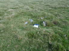
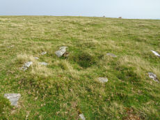
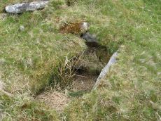
Devils Tor Reported Cist
OS Map: SX 59479 79414
ShortName: CT-DevilsTor
Notes: This feature was reported by Russell Chapman to Bill Radcliffe. The current author was visiting Beardown and had mentioned this to Bill who suggested that it should be checked out. The grid reference given by Russell was SX 59475 79416. The feature is a rectangular pit lined by small stones. It does not have the appearance of a Bronze Age cist. The nature and function of this feature is unclear but would seem most likely to be relatively modern. The author would like to thank Russell and Bill for the details.
Nearby sites: SX 59479 79414
Distance: 0.19km
Higher White Tor Stone Row
OS Map: SX 61917 78362
HER: MDV5834
Megalithic Portal: 2192
The Stone Rows of GB: Higher White Tor
PMD: Higher White Tor Stone Row
ShortName: SR:HigherWhito
Butler map: 29.16
DPD page: 110
Notes: "A Late Neolithic stone alignment on Higher White Tor, surviving as two parallel rows of stones aligned roughly north-south. The alignment is 95.4 metres long and contains twelve upright stones and 24 recumbent ones." Lethbridge diagram and photo p.110.
Nearby sites: SX 61917 78362
Distance: 2.72km
Maiden Hill Cist
OS Map: SX 58831 79380
HER: MDV4216
Megalithic Portal: 45815
PMD: Maiden Hill
Alternate name: Conies Down Summit Cist
ShortName: CT:MaidenHill
Butler map: 30.11
Butler Vol 5: p.158 & Fig.28
DPD page: 108
Grinsell: LYD 32
Notes: Maybe natural rather than a cist. "large turf-covered cairn which has been dug into from its southern edge. No stones are visible in the saucer-shape depression in the centre but a setting of three slabs near the northern edge may be the sides of a cist which contained a secondary burial inserted at a later date into the side of the mound" (Butler). Lethbridge diagram p.107, photo p.108. Butler Vol 2 30.11 p. 77. See very useful notes on Megalithic Portal.
Nearby sites: SX 58831 79380
Distance: 0.70km
Wistman's wood Settlement
OS Map: SX 6125 7750
HER: MDV66036
Megalithic Portal: 42854
ShortName: ST:Wistmans
Nearby sites: SX 6125 7750
Distance: 2.73km