
Prehistoric sites within 2km of SX 55870 63210
Guidance for walkers: The monuments featured in this database are archaeological treasures and need to be protected and preserved - please do not disturb any sites. Please check access and firing times before visiting sites, not all sites listed are on open access land. Firing ranges and boundaries of open access areas are marked on the OL28 OS Dartmoor Explorer map. Please stick to the country code and consider giving support to the numerous agencies that help to keep Dartmoor a fabulous natural and historic environment!
About the database listings: In all listings clicking on the photo or the site name will open a page for the site with a larger photo and further details from the database. The database now has over 6680 records covering nearly all publicly listed sites on Dartmoor including around 4800 round houses. This level of detail is of interest to archaeologists but tends to swamp listings of sites more likely to be of interest for walkers. For this reason, the listings default to around 550 core sites only. These are the stone circles, stone rows and the ring cairns listed by Turner. The default search radius is 2 km. The controls below the map can be used to start a new search by entering a 6- or 8-digit reference (without the prefix "SX"). The search radius can be specified and you can add incremental Display layers of detail on top of the core sites. If using a more detailed layer you will need to decrease the search radius to avoid getting hundreds of search results.
- Core sites Default listing of core sites consisting of stone circles & rows and some of the major ring cairns.
- Plus cairns adds approx. 1000 cairns and other minor sites not included in the core listings but excluding round houses.
- Plus round houses adds approx. 4800 round houses.
- Plus non-sites adds in the records for sites that no longer exist or are not prehistoric sites.
- Plus duplicates adds records excluded as duplicates. Those maybe duplicate records in external listings (e.g. the Historic Environment Records). For example, some sites have been identified as cairns in some listings and interpreted as round houses in other listings and both records appear.
These listings have incorporated, matched up and merged all of the records from all of the major archaeological listings including: Worth, Grinsell, Turner, Butler, Bill Radcliffe, Sandy Gerrard, Megalithic Portal, the National Monument Records and the Historic Environment Records. The author would like to thank Bill, Sandy, the lovely people both at Megalithic Portal (especially Anne Tate who did an amazing job to link listings) and at ACE Archaeology for collaborative work over the years to synchronise and correct listings across the various websites which now interlink. A culmination of years of work the final merger of cairn records took 3 months of cross referencing in 2017 the result being a snapshot of the records at that time. This data has in turn been refined since by field work and research. The round house data was supplied by Sandy Gerrard. Grid references are in order of accuracy: from Google Earth satellite, if visible and found, from a Garmin GPS reading, if visited by the author and from the literature otherwise. Individual site pages will state the source of the grid reference and provide satellite imagery. If a site listing lacks a photo it has not yet been visited by the author in which case the grid reference is from the literature.
Currently the database only includes sites which can be represented by a grid reference. Reaves are not included as they require GIS shape technology which is beyond the current capability of this system. To see the sources for the records, look at the tables on the resources menu. The database listings can also be viewed on a Google map and downloaded as GPS datasets for Garmin devices.
Corrections, or any feedback or suggestions are very welcome, email: info@dartmoorwalks.org.uk.
NOTE: Clicking on the icons for each monument in the map will give the name of the site. You can zoom in and out and drag the map around.
List of sites within 2km of SX 55870 63210
Brisworthy Cup Stone
OS Map: SX 5598 6516
HER: MDV18859
Megalithic Portal: 45854
ShortName: CS:Brisworthy
Butler map: 49.18
DPD page: 34
Notes: HER: "Possible prehistoric cup-marked boulder of granite with at least 15 hollows, originally interpreted as a tinners' mortarstone in the early 20th century incorporated into a hedge/field boundary at Brisworthy."
Nearby sites: SX 5598 6516
Distance: 1.95km
Collard Tor Encircled Cairn
OS Map: SX 5584 6203
HER: MDV14793
Megalithic Portal: 794
PMD: Collard Tor
Alternate name: Collard Tor stone row 1 Encircled Cairn
ShortName: EC Collard Tor
Butler map: 48.6.1
DPD page: 57
Grinsell: SHA 46
Turner: F17
Barrow Report: 22
Notes: Cairn heading the easterly of the two Collard Tor rows. "The easterly cairn at SX 55846203 measures 8.1m. in diameter and 0.6m. high. The centre has been excavated, but apart from a large prone slab there is nothing to suggest a former cist. The mound is surrounded by a peristalith of boulders each of which is 0.9m. high and roughly 0.5m square. The row is similar to the other row and can be traced for 79.6m."
Nearby sites: SX 5584 6203
Distance: 1.18km
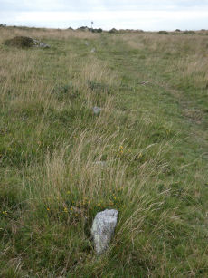
Collard Tor E. Stone Row
OS Map: SX 55849 62035
HER: MDV14792
Megalithic Portal: 1842
The Stone Rows of GB: Collard Tor East
PMD: Collard Tor E Stone Row
Alternate name: Collard Tor E Stone Row
ShortName: SR CollardTorE
Butler map: 48.6.2
DPD page: 57
Notes: Butler Collard Tor 1. "Two stone rows each headed by a cairn lie on a gentle clitter-covered south-facing hillslope between 239m and 259m above OD. The rows which are oriented approximately north-south, diverge from their northern ends and are from 17m to 19 apart; a field bank interrupts the course of the east row.
Nearby sites: SX 55849 62035
Distance: 1.18km
Collard Tor W. Stone Row
OS Map: SX 55833 62045
HER: MDV2583
Megalithic Portal: 1843
The Stone Rows of GB: Collard Tor West
PMD: Collard Tor W Stone Row
Alternate name: Collard Tor W Stone Row
ShortName: SR CollardTorW
Butler map: 48.6.1
DPD page: 57
Notes: Butler Collard Tor 2. Described in entry for Collard Tor E. Lethbridge pp.55-7, diagram p.55.
Nearby sites: SX 55833 62045
Distance: 1.17km
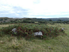
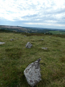
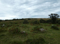
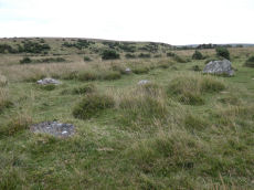
Saddlesborough Stone Ring Cairn Circle
OS Map: SX 5587 6321
HER: MDV2433
Megalithic Portal: 45840
Alternate name: Saddlesborough Summit Stone Ring Cairn Circle
ShortName: RC Saddlesboro
Butler map: 48.3
Turner: A45
Notes: "Stone ring with an annular bank. The interior is part infilled with small stones and boulders to 0.3 meters or less below the bank top. This cairn measures 15.5 meters in diameter, with a bank 1.3 meters wide and 0.4 meters high. The interior has been dug into. Situated on a level summit."
The two entries SiteID=545 and SiteID=1472 are probably correct but the area is disturbed by tin workings and further confirmation is required that the correct features have been identified in the field (in terms of photos - visit 12 Sep 2022). Grid references not updated due to doubt about ID.
Nearby sites: SX 5587 6321
Distance: 0.00km
Shadyback Tor Settlement
OS Map: SX 566 650
HER: MDV56780
Megalithic Portal: 34063
ShortName: ST:Shadyback
Nearby sites: SX 566 650
Distance: 1.93km
Shaugh Cross Platform Cairn Circle
OS Map: SX 5532 6346
HER: MDV2524
Megalithic Portal: 17513
Alternate name: Saddlesborough reave Platform Cairn Circle
ShortName: PC:ShaughCross
Butler map: 48.5
Grinsell: SHA 40
Turner: E2
Notes: A barrow lies 109.7m west from the retaining circle (sx56se/24) of the stone row on shaugh moor. There is a kerb of stones visible and a wider spread of material up to 12.19m (worth). Barrow diam 12.19m, height 1.524m.
Nearby sites: SX 5532 6346
Distance: 0.60km
Shaugh Moor Platform Cairn Circle
OS Map: SX 55476 63479
HER: MDV2572
Megalithic Portal: 52699
Alternate name: Saddlesborough N.W. Platform Cairn Circle
ShortName: PC Shaugh Moor
Butler map: 48.5
Grinsell: SHA 41b
Turner: E3
Notes: Ring cairn or traces of cairn with retaining circle, found by plymouth archaeological group 1959. Diameter 11.5m, height 0.3m. No.416. Vis=-/7/1959 (ancient monuments). Cairn, height 2ft, diameter 30ft, east of and close to stone row. Distinct stone kerb with low flat mound within.
Nearby sites: SX 55476 63479
Distance: 0.48km
Shaugh Moor Enclosed Settlement
OS Map: SX 55655 63455
HER: MDV12778
Megalithic Portal: 17512
ShortName: ES:Shaugh Moor
Notes: Butler Vol 3 Map 48, 3. See Fig 48.3 p.100 for diagram of enclosures A-G. The best defined is enclosure A which is around 250 metres to the east of this grid reference. This grid reference marks a squarish enclosure G.
Nearby sites: SX 55655 63455
Distance: 0.33km
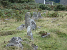
Shaugh Moor Stone Row
OS Map: SX 55422 63435
HER: MDV2434
Megalithic Portal: 2121
The Stone Rows of GB: Shaugh Moor
PMD: Shaugh Moor Stone Row
Alternate name: Shaugh Moor row Stone Row
ShortName: SR ShaughMoor
Butler map: 48.5
DPD page: 55
Notes: "A single stone row 587 feet long, the spacing of the stones varies between 3 feet and 5 feet, centre to centre. At the Southwest end there is a retaining circle 50 feet in diameter. The stones of the row are very small and sunk into the peat, making them hard to find. A stone row 164m long aligned SW-NE over the brow and down the south side of the valley. The terminals are not intervisible. It is composed of small stones, normally between 35 and 10cm high, the tallest (65cms) being at the apparent northern terminal. Where the stones have been removed their original positions can be identified from depressions in the turf". Lethbridge p.54-55, diagram p.55. See also: Sea Views at Shaugh Moor
Nearby sites: SX 55422 63435
Distance: 0.50km
Shaugh Moor (N) Cairn Circle
OS Map: SX 55419 63496
HER: MDV5596
Megalithic Portal: 3458
Alternate name: Shaugh Moor N.1 Cairn Circle
ShortName: CC ShaughMo N1
Turner: G18
Notes: "Whether the stones represent the remnants of a stone circle, a cairn circle, or even a hut is debateable". "The remains of a circle of stones lie on a north-west facing hill slope at 256m above OD on unenclosed moorland. It survives as a partial ring of five boulder and stones with an off-centre earthfast boulder; the overall diameter was approximately 10.0m to 10.6m across. The largest of the two slabs which remain upright is 0.8m high, 1.7m wide and 0.3m thick."
Nearby sites: SX 55419 63496
Distance: 0.53km
Shaugh Moor (S) Cairn Circle
OS Map: SX 55419 63427
HER: MDV49564
Megalithic Portal: 52567
PMD: Shaugh Moor Stone Row
Alternate name: Shaugh Moor stone row Cairn Circle
ShortName: CC ShaughMoorS
Butler map: 48.5
DPD page: 55
Grinsell: SHA 41
Turner: G17
Notes: Cairn circle at the southern end of the Shaugh Moor stone row. "An egg-shaped ring of stone uprights". "Only an arc of four clearly identifiable stones survive in the circle; they are a maximum 0.3m high and suggest an approximate circle diameter of 15.0m. There are a number of buried and semi-buried stones traceable but their relationship to the circle is unclear". Lethbridge p.54-55, diagram p.55
Nearby sites: SX 55419 63427
Distance: 0.50km
Trowlesworthy E. Stone Row
Prehistoric Dartmoor Walks: Dartmoor Site: Trowlesworthy, Settlements, Stone Row & Cairn Circle
OS Map: SX 57646 63972
HER: MDV2421
Megalithic Portal: 3516
The Stone Rows of GB: Trowlesworthy 1
PMD: Trowlesworthy E Stone Row
Alternate name: Trowlesworthy 1 Stone Row
ShortName: SR Trowles E
Butler map: 51.8.1
Butler Vol 5: p.229 & Fig.163
DPD page: 57
Notes: Butler Trowlesworthy 1. "A Bronze Age stone alignment comprising a double stone row consisting of 99 upright and 8 recumbent stones running south-south-west from a possible stone circle near the foot of the south flank of Little Trowlesworthy Tor. The surviving length of the row is about 129 metres, it is bisected by a leat. The better preserved element of the row is down the slope from the leat. The circle comprises 8 main orthostat stones in a "kidney-shaped" plan. The south-west orthostat in the ring is surrounded by a number of smaller stones". Lethbridge p.57-8, diagram p.58. See also, Legendary Dartmoor: The Pulpit and Sea Views at Trowlesworthy 1
Nearby sites: SX 57646 63972
Distance: 1.93km
Trowlesworthy W. Stone Row
Prehistoric Dartmoor Walks: Dartmoor Site: Trowlesworthy, Settlements, Stone Row & Cairn Circle
OS Map: SX 57536 63978
HER: MDV2415
Megalithic Portal: 2176
The Stone Rows of GB: Trowlesworthy 2
PMD: Trowlesworthy W Stone Row
Alternate name: Trowlesworthy 2 Stone Row
ShortName: SR Trowles W
Butler map: 51.8.2
DPD page: 58
Notes: Butler Trowlesworthy 2. "A single stone row consisting of 35 upright and 13 recumbent stones running in an E to W line from the site of a possible ring cairn at the foot of the SW flank of Little Trowlesworthy Tor. The cairn at the head of the row is marked by a circle containing one upright and eight fallen small slabs and boulders. Within these is a slightly raised area, perhaps the remains of a cairn." Lethbridge p.57-8, diagram p.58.
Nearby sites: SX 57536 63978
Distance: 1.83km
Trowlesworthy Warren (E) Cairn Circle
Prehistoric Dartmoor Walks: Dartmoor Site: Trowlesworthy, Settlements, Stone Row & Cairn Circle
OS Map: SX 57651 63983
HER: MDV49511
Megalithic Portal: 529
PMD: Trowlesworthy E Stone Row
Alternate name: Trowlesworthy stone row 1 Cairn Circle
ShortName: CC Trowles E
Butler map: 51.8.1
Butler Vol 5: p.229 & Fig.163
DPD page: 58
Grinsell: SHA 44
Turner: G25
Notes: Cairn circle at head of stone row. "The circle 6.5m. in diameter comprises eight orthostats from 0.7m. to 1.5m. high. In some cases the 'trig' stones are visible." "The alleged cairn at the head of the row comprises a ring of eight stones a maximum of 1.2m high with no evidence of a cist and very little to suggest the former presence of a cairn. It would seem more likely to represent the remains of a small stone circle albeit only 6.0 to 6.5m in diameter." See also, Legendary Dartmoor: The Pulpit. Lethbridge p.57-8, diagram p.58.
Nearby sites: SX 57651 63983
Distance: 1.94km
Trowlesworthy Warren (W) Cairn Circle
Prehistoric Dartmoor Walks: Dartmoor Site: Trowlesworthy, Settlements, Stone Row & Cairn Circle
OS Map: SX 57544 63986
HER: MDV49509
Megalithic Portal: 3517
PMD: Trowlesworthy W Stone Row
Alternate name: Trowlesworthy stone row 2 Cairn Circle
ShortName: CC Trowles W
Butler map: 51.8.2
Grinsell: SHA 43
Turner: G26
Notes: This is a cairn circle at the east end of the Trowlesworthy Warren (W) stone row. "At the east is a 4.5m. diameter circle of 10 stones; average height 0.4m. There is no visible cairn or cist in the centre. Two upright stones immediately to the north west of the circle are probably associated. "
Nearby sites: SX 57544 63986
Distance: 1.85km
Wigford Down Platform Cairn Circle and Cist
OS Map: SX 54419 64427
HER: MDV2373
Megalithic Portal: 3536
PMD: Wigford Down S.
Alternate name: Wigford Down 1 Platform Cairn Circle and Cist
ShortName: CT:Wigford 1
Butler map: 48.1.1
DPD page: 33
Grinsell: MEA 7
Turner: E6
Barrow Report: 12 19
Notes: "A badly disturbed prehistoric cist with displaced cover stone and vestiges of a retaining circle surviving in situ. Only five slabs of the retaining circle survive approximately upright in situ, suggesting the overall diameter of the complete circle was 8.35m. The long slabs of the central cist are also in situ and the chamber measures 1.1m by 0.28m approximately by 0.3m deep. A large, flat, intact cover stone of 1.4m by 1.17m, with a rounded end, is displaced to the south. Some material from the turf covered cairn is still visible, but much disturbed and depleted." Butler Wigford Down 1 - Vol. 3. Map 48.1 (diagram p.80).
Nearby sites: SX 54419 64427
Distance: 1.89km