
Prehistoric sites within 2km of SX 55300 89100
Guidance for walkers: The monuments featured in this database are archaeological treasures and need to be protected and preserved - please do not disturb any sites. Please check access and firing times before visiting sites, not all sites listed are on open access land. Firing ranges and boundaries of open access areas are marked on the OL28 OS Dartmoor Explorer map. Please stick to the country code and consider giving support to the numerous agencies that help to keep Dartmoor a fabulous natural and historic environment!
About the database listings: In all listings clicking on the photo or the site name will open a page for the site with a larger photo and further details from the database. The database now has over 6680 records covering nearly all publicly listed sites on Dartmoor including around 4800 round houses. This level of detail is of interest to archaeologists but tends to swamp listings of sites more likely to be of interest for walkers. For this reason, the listings default to around 550 core sites only. These are the stone circles, stone rows and the ring cairns listed by Turner. The default search radius is 2 km. The controls below the map can be used to start a new search by entering a 6- or 8-digit reference (without the prefix "SX"). The search radius can be specified and you can add incremental Display layers of detail on top of the core sites. If using a more detailed layer you will need to decrease the search radius to avoid getting hundreds of search results.
- Core sites Default listing of core sites consisting of stone circles & rows and some of the major ring cairns.
- Plus cairns adds approx. 1000 cairns and other minor sites not included in the core listings but excluding round houses.
- Plus round houses adds approx. 4800 round houses.
- Plus non-sites adds in the records for sites that no longer exist or are not prehistoric sites.
- Plus duplicates adds records excluded as duplicates. Those maybe duplicate records in external listings (e.g. the Historic Environment Records). For example, some sites have been identified as cairns in some listings and interpreted as round houses in other listings and both records appear.
These listings have incorporated, matched up and merged all of the records from all of the major archaeological listings including: Worth, Grinsell, Turner, Butler, Bill Radcliffe, Sandy Gerrard, Megalithic Portal, the National Monument Records and the Historic Environment Records. The author would like to thank Bill, Sandy, the lovely people both at Megalithic Portal (especially Anne Tate who did an amazing job to link listings) and at ACE Archaeology for collaborative work over the years to synchronise and correct listings across the various websites which now interlink. A culmination of years of work the final merger of cairn records took 3 months of cross referencing in 2017 the result being a snapshot of the records at that time. This data has in turn been refined since by field work and research. The round house data was supplied by Sandy Gerrard. Grid references are in order of accuracy: from Google Earth satellite, if visible and found, from a Garmin GPS reading, if visited by the author and from the literature otherwise. Individual site pages will state the source of the grid reference and provide satellite imagery. If a site listing lacks a photo it has not yet been visited by the author in which case the grid reference is from the literature.
Currently the database only includes sites which can be represented by a grid reference. Reaves are not included as they require GIS shape technology which is beyond the current capability of this system. To see the sources for the records, look at the tables on the resources menu. The database listings can also be viewed on a Google map and downloaded as GPS datasets for Garmin devices.
Corrections, or any feedback or suggestions are very welcome, email: info@dartmoorwalks.org.uk.
NOTE: Clicking on the icons for each monument in the map will give the name of the site. You can zoom in and out and drag the map around.
List of sites within 2km of SX 55300 89100
Little Links Tor 1 Cairn
OS Map: SX 5428 8747
HER: MDV51428
ShortName: CN:LittleLink1
Notes: HER: Ring cairn. Survives as a circular bank 2m wide and 0.4m high surrounding an internal area measuring 13m in diameter. A 3m wide gap in the western side of the bank may be the result of partial robbing. This ring cairn is of the unrevetted without central mound variety.
Nearby sites: SX 5428 8747
Distance: 1.92km
Little Links Tor 2 Cairn
OS Map: SX 54291 87520
HER: MDV125847
ShortName: CN:LittleLink2
Notes: HER quoting Greeves: Apparently unrecorded prehistoric cairn in the upper reaches of the River Lyd, approximately 150 metres north of the Smallacombe valley. Located at SX 54291 87520, approximately 30 metres north-west of ring cairn MDV51428. It is a low cairn mound with a relatively level top, no more than about 0.30 metres in height, approximately 10 metres by 9.0 metres in diameter.
It lies not far north of the stone alignment MDV51434, which due to the significant amount of prehistoric activity in this area, is likely to be a prehistoric stone row.
Nearby sites: SX 54291 87520
Distance: 1.87km
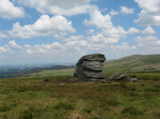
Branscombe's Loaf Stone Ring Cairn Circle
OS Map: SX 55305 89126
HER: MDV48863
Megalithic Portal: 45843
Alternate name: Branscombe's Loaf Stone Ring Cairn Circle
ShortName: RC Branscomb 6
Turner: A57
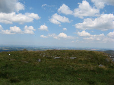
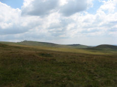
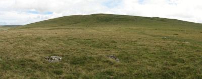
Notes: One of 4 cairns on Corn Ridge - see Turner "Ring Cairns, Stone Circles and Related Monuments on Dartmoor" DASP No. 48 p59 for diagram of the 4 cairns. This one is a "tor cairn" - a circular bank enclosing a rocky outcrop. The circle can be seen clearly on Google Earth satellite imagery.
Nearby sites: SX 55305 89126
Distance: 0.03km
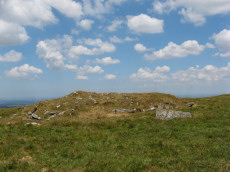
Corn Ridge Stone Ring Cairn Circle
OS Map: SX 55138 89153
HER: MDV3172
Megalithic Portal: 52276
Alternate name: Branscombe's Loaf 2 Stone Ring Cairn Circle
ShortName: RC Branscomb 2
Butler map: 43.12.2
Grinsell: BRI 10
Turner: A14
Notes: This ring cairn can just about be seen in the photograph that accompanies this record, it is a bit difficult to capture in a photograph. It is a bit of an indistinct circular bank. It is perhaps easier to see in the Google Earth satellite imagery - which can help to then make sense of the photograph. One of 4 cairns on Corn Ridge - see Turner "Ring Cairns, Stone Circles and Related Monuments on Dartmoor" DASP No. 48 p59 for diagram of the 4 cairns.
Nearby sites: SX 55138 89153
Distance: 0.17km
Corn Ridge Encircled Cairn
OS Map: SX 55175 89119
HER: MDV3171
Megalithic Portal: 3158
Alternate name: Branscombe's Loaf 1 Encircled Cairn
ShortName: EC Branscomb 1
Butler map: 43.12.1
Grinsell: BRI 9
Turner: F2
Notes: One of 4 cairns on Corn Ridge - see Turner "Ring Cairns, Stone Circles and Related Monuments on Dartmoor" DASP No. 48 p59 for diagram of the 4 cairns.
Nearby sites: SX 55175 89119
Distance: 0.13km
Corn Ridge N.W.1 Cairn
OS Map: SX 54603 89454
HER: MDV4627
Megalithic Portal: 10022
ShortName: CN CornRg NW1
Butler map: 43.10.1
Grinsell: BRI 1
Notes: Butler Corn Ridge NW1. Southern most of pair of cairns near stone circle. "The remains of a cairn, SX 54608942, which has been disturbed in the past - now heather covered. Diameter 10.5m, height 0.5m. One or two stones of the retaining circle are still visible but there is no trace of a cist to be seen." Previously listed as Sourton Tors S.E. - changed to the Butler name as less confusing given part of a pair of cairns
Nearby sites: SX 54603 89454
Distance: 0.78km
Corn Ridge Rock Stone Ring Cairn Circle
OS Map: SX 55219 89145
HER: MDV48864
Megalithic Portal: 45850
Alternate name: Branscombe's Loaf 3 Stone Ring Cairn Circle
ShortName: RC Branscomb 3
Butler map: 43.12.3
Turner: A66
Notes: "Tor cairn on summit of Corn Ridge. Two banks of small to medium stones associated with large outcrop. Outer bank survives as 12 metres long, 1.2 metres wide, 0.3 metres high curving rubble spread following s + w edges of the outcrop. Inner ring measures 1.3m wide, 0.3m high and corresponds with the n edge of the outcrop, but also extends over the rock itself, which stands 3m high. Area enclosed by ring banks measures 15m ns by 12m ew" One of 4 cairns on Corn Ridge - see Turner "Ring Cairns, Stone Circles and Related Monuments on Dartmoor" DASP No. 48 p59 for diagram of the 4 cairns.
Nearby sites: SX 55219 89145
Distance: 0.09km
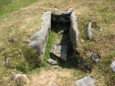
Homerton Hill N. Cist
OS Map: SX 56132 90651
HER: MDV12884
Megalithic Portal: 45808
PMD: Homerton Hill
ShortName: CT Homerton N
Butler map: 43.15
Butler Vol 5: p.177 & Fig.119
DPD page: 157
Notes: Butler Homerton Hill N. Vol. 2. Map 43.15 (diagram Vol. 5. p.177). A small, disturbed cairn containing three edge set stones of a cist ... The turf covered cairn measures 3.5 x 3.1m and 0.3m max. height. The top and north side of the mound has been disturbed exposing the three in situ cist stones. The cist measures 0.8 x 0.6m and 0.3mdeep. It is now open to the north. A large stone lying flush with the ground lies immediately north east of the cairn and probably represents the missing endstone or the coverstone. Lethbridge diagram p.156 and photos p157.
Nearby sites: SX 56132 90651
Distance: 1.76km
Sourton Common Stone Ring Cairn Circle
OS Map: SX 54418 88858
HER: MDV4674
Megalithic Portal: 10023
Alternate name: Corn Ridge W.1 Stone Ring Cairn Circle
ShortName: RC CornRg W1
Butler map: 43.8.1
Grinsell: BRI 3
Turner: A33
Notes: "Ring cairn surviving as a circular bank 4m wide and 0.7m high surrounding an internal area measuring 12m in diam. Four small hollows in the ring bank suggest partial early excavation or robbing" NMR B.
Nearby sites: SX 54418 88858
Distance: 0.91km
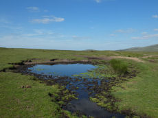
Sourton Tors Ancient Pool
OS Map: SX 54596 89607
HER: MDV127223
ShortName: PO Sourton Tor
Notes: Pool measures 12 by 10.5m. One of over 40 such 'sacred' pools identified on Dartmoor that are thought to have potentially been designed during the prehistoric period, and may have been used to deposit votive items, although these Dartmoor examples may have alternative significance as designed prehistoric elements in the landscape. Many are located on ridge tops and in conjunction with cairns, stone rows and other prehistoric features. Further research may well reveal more about these interesting features.
Nearby sites: SX 54596 89607
Distance: 0.87km
Sourton Tors Stone Circle
OS Map: SX 54683 89587
HER: MDV4626
Megalithic Portal: 3472
PMD: Sourton (Corn Ridge) Stone Circle
ShortName: SC Sourton Tor
Butler map: 43.6
Turner: G3
Notes: "A stone circle, diameter about 110 ft and appearing to have comprised 32 stones of which all but six remain where they have fallen, has been discovered between Sourton Tors and Cornridge. In size it compares with the circles of the Grey Wethers and Scorhill". For a photo of this site, see: Megalithic Portal: Sourton Tors Stone Circle
Nearby sites: SX 54683 89587
Distance: 0.79km