
Prehistoric sites within 2km of SX 66945 65556
Guidance for walkers: The monuments featured in this database are archaeological treasures and need to be protected and preserved - please do not disturb any sites. Please check access and firing times before visiting sites, not all sites listed are on open access land. Firing ranges and boundaries of open access areas are marked on the OL28 OS Dartmoor Explorer map. Please stick to the country code and consider giving support to the numerous agencies that help to keep Dartmoor a fabulous natural and historic environment!
About the database listings: In all listings clicking on the photo or the site name will open a page for the site with a larger photo and further details from the database. The database now has over 6680 records covering nearly all publicly listed sites on Dartmoor including around 4800 round houses. This level of detail is of interest to archaeologists but tends to swamp listings of sites more likely to be of interest for walkers. For this reason, the listings default to around 550 core sites only. These are the stone circles, stone rows and the ring cairns listed by Turner. The default search radius is 2 km. The controls below the map can be used to start a new search by entering a 6- or 8-digit reference (without the prefix "SX"). The search radius can be specified and you can add incremental Display layers of detail on top of the core sites. If using a more detailed layer you will need to decrease the search radius to avoid getting hundreds of search results.
- Core sites Default listing of core sites consisting of stone circles & rows and some of the major ring cairns.
- Plus cairns adds approx. 1000 cairns and other minor sites not included in the core listings but excluding round houses.
- Plus round houses adds approx. 4800 round houses.
- Plus non-sites adds in the records for sites that no longer exist or are not prehistoric sites.
- Plus duplicates adds records excluded as duplicates. Those maybe duplicate records in external listings (e.g. the Historic Environment Records). For example, some sites have been identified as cairns in some listings and interpreted as round houses in other listings and both records appear.
These listings have incorporated, matched up and merged all of the records from all of the major archaeological listings including: Worth, Grinsell, Turner, Butler, Bill Radcliffe, Sandy Gerrard, Megalithic Portal, the National Monument Records and the Historic Environment Records. The author would like to thank Bill, Sandy, the lovely people both at Megalithic Portal (especially Anne Tate who did an amazing job to link listings) and at ACE Archaeology for collaborative work over the years to synchronise and correct listings across the various websites which now interlink. A culmination of years of work the final merger of cairn records took 3 months of cross referencing in 2017 the result being a snapshot of the records at that time. This data has in turn been refined since by field work and research. The round house data was supplied by Sandy Gerrard. Grid references are in order of accuracy: from Google Earth satellite, if visible and found, from a Garmin GPS reading, if visited by the author and from the literature otherwise. Individual site pages will state the source of the grid reference and provide satellite imagery. If a site listing lacks a photo it has not yet been visited by the author in which case the grid reference is from the literature.
Currently the database only includes sites which can be represented by a grid reference. Reaves are not included as they require GIS shape technology which is beyond the current capability of this system. To see the sources for the records, look at the tables on the resources menu. The database listings can also be viewed on a Google map and downloaded as GPS datasets for Garmin devices.
Corrections, or any feedback or suggestions are very welcome, email: info@dartmoorwalks.org.uk.
NOTE: Clicking on the icons for each monument in the map will give the name of the site. You can zoom in and out and drag the map around.
List of sites within 2km of SX 66945 65556
Brockhill Foot W Round House
OS Map: SX 67732 65457
HER: MDV14799
ShortName: HT:Brockhill13
Nearby sites: SX 67732 65457
Distance: 0.79km
Brockhill Foot W Round House
OS Map: SX 67696 65474
HER: MDV14799
ShortName: HT:Brockhill14
Nearby sites: SX 67696 65474
Distance: 0.76km
Brockhill Foot W Round House
OS Map: SX 67808 65461
HER: MDV14799
ShortName: HT:Brockhill15
Nearby sites: SX 67808 65461
Distance: 0.87km
Brockhill Foot W Round House
OS Map: SX 67717 65486
HER: MDV14799
ShortName: HT:Brockhill16
Nearby sites: SX 67717 65486
Distance: 0.78km
Brockhill Foot W Round House
OS Map: SX 67794 65432
HER: MDV14799
ShortName: HT:Brockhill17
Nearby sites: SX 67794 65432
Distance: 0.86km
Brockhill Foot W Round House
OS Map: SX 67793 65449
HER: MDV14799
ShortName: HT:Brockhill18
Nearby sites: SX 67793 65449
Distance: 0.85km
Brockhill Foot W Round House
OS Map: SX 67726 65460
HER: MDV14799
ShortName: HT:Brockhill19
Nearby sites: SX 67726 65460
Distance: 0.79km
Brockhill Foot W Round House
OS Map: SX 67724 65689
HER: MDV5233
ShortName: HT:Brockhill20
Nearby sites: SX 67724 65689
Distance: 0.79km
Brockhill Foot W Round House
OS Map: SX 67731 65689
HER: MDV5233
ShortName: HT:Brockhill21
Nearby sites: SX 67731 65689
Distance: 0.80km
Brockhill Foot W Round House
OS Map: SX 67692 65452
HER: MDV14799
ShortName: HT:Brockhill22
Nearby sites: SX 67692 65452
Distance: 0.75km
Huntingdon Warren 1 Reported Cairn
OS Map: SX 6586 6635
HER: MDV-1
ShortName: CNxHuntingdo1
Butler map: 58.1.1
Notes: Hut circle or pillow mound?
Nearby sites: SX 6586 6635
Distance: 1.34km
Huntingdon Warren 2 Reported Cairn
OS Map: SX 6606 6635
HER: MDV-1
ShortName: CNxHuntingdo2
Butler map: 58.1.2
Notes: Hut circle or pillow mound?
Nearby sites: SX 6606 6635
Distance: 1.19km
Crad Hole Ring Cairn Circle
OS Map: SX 6721 6650
HER: MDV5260
ShortName: CC:Crad Hole1
Butler map: 58.2
Nearby sites: SX 6721 6650
Distance: 0.98km
Buckland Ford W Round House
OS Map: SX 65643 66156
HER: MDV5321
ShortName: HT:Buckland 13
Nearby sites: SX 65643 66156
Distance: 1.43km
Buckland Ford W Round House
OS Map: SX 65677 66151
HER: MDV5321
ShortName: HT:Buckland 14
Nearby sites: SX 65677 66151
Distance: 1.40km
Buckland Ford W Round House
OS Map: SX 65676 66128
HER: MDV5321
ShortName: HT:Buckland 15
Nearby sites: SX 65676 66128
Distance: 1.39km
Buckland Ford W Round House
OS Map: SX 65643 66125
HER: MDV5321
ShortName: HT:Buckland 16
Nearby sites: SX 65643 66125
Distance: 1.42km
Biller's Pound Round House
OS Map: SX 66754 66142
HER: MDV5188
ShortName: HT:Biller's 1
Nearby sites: SX 66754 66142
Distance: 0.62km
Buckland Ford W Round House
OS Map: SX 65661 66149
HER: MDV5321
ShortName: HT:Buckland 17
Nearby sites: SX 65661 66149
Distance: 1.41km
Biller's Pound Round House
OS Map: SX 66722 66214
HER: MDV5189
ShortName: HT:Biller's 2
Nearby sites: SX 66722 66214
Distance: 0.69km
Buckland Ford W Round House
OS Map: SX 65686 66112
HER: MDV5321
ShortName: HT:Buckland 18
Nearby sites: SX 65686 66112
Distance: 1.38km
Biller's Pound Round House
OS Map: SX 6675 6620
HER: MDV5189
ShortName: HT:Biller's 3
Nearby sites: SX 6675 6620
Distance: 0.67km
Biller's Pound Round House
OS Map: SX 66729 66109
HER: MDV5190
ShortName: HT:Biller's 4
Nearby sites: SX 66729 66109
Distance: 0.59km
Biller's Pound Round House
OS Map: SX 66731 66215
HER: MDV5189
ShortName: HT:Biller's 5
Nearby sites: SX 66731 66215
Distance: 0.69km
Biller's Pound Round House
OS Map: SX 66669 66191
HER: MDV5190
ShortName: HT:Biller's 6
Nearby sites: SX 66669 66191
Distance: 0.69km
Biller's Pound Round House
OS Map: SX 66723 66127
HER: MDV5190
ShortName: HT:Biller's 7
Nearby sites: SX 66723 66127
Distance: 0.61km
Biller's Pound Round House
OS Map: SX 66657 66188
HER: MDV5190
ShortName: HT:Biller's 8
Nearby sites: SX 66657 66188
Distance: 0.69km
Biller's Pound Round House
OS Map: SX 66694 66206
HER: MDV5189
ShortName: HT:Biller's 9
Nearby sites: SX 66694 66206
Distance: 0.70km
Hickaton Hill Round House
OS Map: SX 67192 66471
HER: MDV5295
ShortName: HT:Hickaton 1
Nearby sites: SX 67192 66471
Distance: 0.95km
Biller's Pound Round House
OS Map: SX 66693 66199
HER: MDV5189
ShortName: HT:Biller's 10
Nearby sites: SX 66693 66199
Distance: 0.69km
Hickaton Hill Round House
OS Map: SX 67250 66508
HER: MDV5294
ShortName: HT:Hickaton 2
Nearby sites: SX 67250 66508
Distance: 1.00km
Biller's Pound Round House
OS Map: SX 66690 66193
HER: MDV5189
ShortName: HT:Biller's 11
Nearby sites: SX 66690 66193
Distance: 0.69km
Hickaton Hill Round House
OS Map: SX 67236 66498
HER: MDV5294
ShortName: HT:Hickaton 3
Nearby sites: SX 67236 66498
Distance: 0.99km
Biller's Pound Round House
OS Map: SX 66674 66207
HER: MDV5190
ShortName: HT:Biller's 12
Nearby sites: SX 66674 66207
Distance: 0.71km
Hickaton Hill Round House
OS Map: SX 67254 66521
HER: MDV5294
ShortName: HT:Hickaton 4
Nearby sites: SX 67254 66521
Distance: 1.01km
Biller's Pound Round House
OS Map: SX 66653 66204
HER: MDV5190
ShortName: HT:Biller's 13
Nearby sites: SX 66653 66204
Distance: 0.71km
Hickaton Hill Round House
OS Map: SX 67245 66509
HER: MDV5294
ShortName: HT:Hickaton 5
Nearby sites: SX 67245 66509
Distance: 1.00km
Biller's Pound Round House
OS Map: SX 66667 66201
HER: MDV5190
ShortName: HT:Biller's 14
Nearby sites: SX 66667 66201
Distance: 0.70km
Hickaton Hill Round House
OS Map: SX 67248 66519
HER: MDV5294
ShortName: HT:Hickaton 6
Nearby sites: SX 67248 66519
Distance: 1.01km
Biller's Pound Round House
OS Map: SX 66656 66215
HER: MDV5190
ShortName: HT:Biller's 15
Nearby sites: SX 66656 66215
Distance: 0.72km
Hickaton Hill Round House
OS Map: SX 67235 66510
HER: MDV5294
ShortName: HT:Hickaton 7
Nearby sites: SX 67235 66510
Distance: 1.00km
Biller's Pound Round House
OS Map: SX 66665 66211
HER: MDV5190
ShortName: HT:Biller's 16
Nearby sites: SX 66665 66211
Distance: 0.71km
Hickaton Hill E Round House
OS Map: SX 6827 6685
HER: MDV24781
ShortName: HT:Hickaton 8
Nearby sites: SX 6827 6685
Distance: 1.85km
Biller's Pound Round House
OS Map: SX 66727 66215
HER: MDV5189
ShortName: HT:Biller's 17
Nearby sites: SX 66727 66215
Distance: 0.69km
Hickaton Hill E Round House
OS Map: SX 68020 66671
ShortName: HT:Hickaton 9
Nearby sites: SX 68020 66671
Distance: 1.55km
Huntingdon Warren Round House
OS Map: SX 66063 66434
HER: MDV5236
ShortName: HT:Huntingdo1
Nearby sites: SX 66063 66434
Distance: 1.24km
Biller's Pound Round House
OS Map: SX 66734 66093
HER: MDV5190
ShortName: HT:Biller's 18
Nearby sites: SX 66734 66093
Distance: 0.58km
Hickaton Hill E Round House
OS Map: SX 68321 66778
HER: MDV24768
ShortName: HT:Hickaton 10
Nearby sites: SX 68321 66778
Distance: 1.84km
Huntingdon Warren Round House
OS Map: SX 66336 66298
ShortName: HT:Huntingdo2
Nearby sites: SX 66336 66298
Distance: 0.96km
Bishop's Meads Round House
OS Map: SX 66953 65563
HER: MDV5172
ShortName: HT:Bishop's 1
Nearby sites: SX 66953 65563
Distance: 0.01km
Hickaton Hill E Round House
OS Map: SX 6817 6670
HER: MDV24780
ShortName: HT:Hickaton 11
Nearby sites: SX 6817 6670
Distance: 1.68km
Huntingdon Warren Round House
OS Map: SX 66305 66344
HER: MDV5242
ShortName: HT:Huntingdo3
Nearby sites: SX 66305 66344
Distance: 1.02km
Bishop's Meads Round House
OS Map: SX 66974 65515
HER: MDV5172
ShortName: HT:Bishop's 2
Nearby sites: SX 66974 65515
Distance: 0.05km
Hickaton Hill S Round House
OS Map: SX 67415 65628
HER: MDV5303
ShortName: HT:Hickaton 12
Nearby sites: SX 67415 65628
Distance: 0.48km
Huntingdon Warren Round House
OS Map: SX 66182 66475
HER: MDV5319
ShortName: HT:Huntingdo4
Nearby sites: SX 66182 66475
Distance: 1.19km
Bishop's Meads Round House
OS Map: SX 66978 65537
HER: MDV5172
ShortName: HT:Bishop's 3
Nearby sites: SX 66978 65537
Distance: 0.04km
Hickaton Hill S Round House
OS Map: SX 6744 6558
ShortName: HT:Hickaton 13
Nearby sites: SX 6744 6558
Distance: 0.50km
Huntingdon Warren Round House
OS Map: SX 66321 66401
HER: MDV5242
ShortName: HT:Huntingdo5
Nearby sites: SX 66321 66401
Distance: 1.05km
Bishop's Meads Round House
OS Map: SX 66954 65520
HER: MDV5172
ShortName: HT:Bishop's 4
Nearby sites: SX 66954 65520
Distance: 0.04km
Hickaton Hill S Round House
OS Map: SX 67395 65616
HER: MDV5303
ShortName: HT:Hickaton 14
Nearby sites: SX 67395 65616
Distance: 0.45km
Huntingdon Warren Round House
OS Map: SX 6638 6621
HER: MDV5317
ShortName: HT:Huntingdo6
Nearby sites: SX 6638 6621
Distance: 0.86km
Bishop's Meads Round House
OS Map: SX 66945 65556
HER: MDV5172
ShortName: HT:Bishop's 5
Nearby sites: SX 66945 65556
Distance: 0.00km
Hickaton Hill S Round House
OS Map: SX 67424 65707
HER: MDV5304
ShortName: HT:Hickaton 15
Nearby sites: SX 67424 65707
Distance: 0.50km
Huntingdon Warren Round House
OS Map: SX 66091 66440
HER: MDV5236
ShortName: HT:Huntingdo7
Nearby sites: SX 66091 66440
Distance: 1.23km
Bishop's Meads Round House
OS Map: SX 66944 65809
HER: MDV5176
ShortName: HT:Bishop's 6
Nearby sites: SX 66944 65809
Distance: 0.25km
Hickaton Hill S Round House
OS Map: SX 67307 65623
HER: MDV5232
ShortName: HT:Hickaton 16
Nearby sites: SX 67307 65623
Distance: 0.37km
Huntingdon Warren Round House
OS Map: SX 66307 66357
HER: MDV5245
ShortName: HT:Huntingdo8
Nearby sites: SX 66307 66357
Distance: 1.02km
Bishop's Meads Round House
OS Map: SX 66993 65404
ShortName: HT:Bishop's 7
Nearby sites: SX 66993 65404
Distance: 0.16km
Hickaton Hill S Round House
OS Map: SX 67455 65600
ShortName: HT:Hickaton 17
Nearby sites: SX 67455 65600
Distance: 0.51km
Huntingdon Warren Round House
OS Map: SX 65969 66389
HER: MDV5237
ShortName: HT:Huntingdo9
Nearby sites: SX 65969 66389
Distance: 1.28km
Bishop's Meads Round House
OS Map: SX 66957 65537
HER: MDV5172
ShortName: HT:Bishop's 8
Nearby sites: SX 66957 65537
Distance: 0.02km
Hickaton Hill S Round House
OS Map: SX 67433 65635
HER: MDV5303
ShortName: HT:Hickaton 18
Nearby sites: SX 67433 65635
Distance: 0.49km
Huntingdon Warren Round House
OS Map: SX 65917 66414
HER: MDV5237
ShortName: HT:Huntingdo10
Nearby sites: SX 65917 66414
Distance: 1.34km
Bishop's Meads Round House
OS Map: SX 66966 65540
HER: MDV5172
ShortName: HT:Bishop's 9
Nearby sites: SX 66966 65540
Distance: 0.03km
Hickaton Hill SE Round House
OS Map: SX 6753 6589
HER: MDV5227
ShortName: HT:Hickaton 19
Nearby sites: SX 6753 6589
Distance: 0.67km
Huntingdon Warren Round House
OS Map: SX 66200 66479
HER: MDV5319
ShortName: HT:Huntingdo11
Nearby sites: SX 66200 66479
Distance: 1.19km
Bishop's Meads Round House
OS Map: SX 66958 65798
HER: MDV5176
ShortName: HT:Bishop's 10
Nearby sites: SX 66958 65798
Distance: 0.24km
Hickaton Hill SE Round House
OS Map: SX 6775 6595
HER: MDV24691
ShortName: HT:Hickaton 20
Nearby sites: SX 6775 6595
Distance: 0.90km
Huntingdon Warren Round House
OS Map: SX 66060 66434
HER: MDV5236
ShortName: HT:Huntingdo12
Nearby sites: SX 66060 66434
Distance: 1.25km
Bishop's Meads Round House
OS Map: SX 66938 65509
HER: MDV5172
ShortName: HT:Bishop's 11
Nearby sites: SX 66938 65509
Distance: 0.05km
Hickaton Hill SE Round House
OS Map: SX 67529 65851
HER: MDV5227
ShortName: HT:Hickaton 21
Nearby sites: SX 67529 65851
Distance: 0.65km
Huntingdon Warren Round House
OS Map: SX 66356 66424
HER: MDV5242
ShortName: HT:Huntingdo13
Nearby sites: SX 66356 66424
Distance: 1.05km
Bishop's Meads Round House
OS Map: SX 66942 65488
HER: MDV5172
ShortName: HT:Bishop's 12
Nearby sites: SX 66942 65488
Distance: 0.07km
Hickaton Hill SE Round House
OS Map: SX 67664 65985
HER: MDV5227
ShortName: HT:Hickaton 22
Nearby sites: SX 67664 65985
Distance: 0.84km
Huntingdon Warren Round House
OS Map: SX 66221 66494
HER: MDV5319
ShortName: HT:Huntingdo14
Nearby sites: SX 66221 66494
Distance: 1.18km
Rider's Rings Round House
OS Map: SX 67814 64347
HER: MDV5767
ShortName: HT:Rider's R1
Nearby sites: SX 67814 64347
Distance: 1.49km
Bishop's Meads Round House
OS Map: SX 66949 65794
HER: MDV5176
ShortName: HT:Bishop's 13
Nearby sites: SX 66949 65794
Distance: 0.24km
Hickaton Hill SE Round House
OS Map: SX 67588 65994
HER: MDV5227
ShortName: HT:Hickaton 23
Nearby sites: SX 67588 65994
Distance: 0.78km
Huntingdon Warren Round House
OS Map: SX 66111 66392
HER: MDV5236
ShortName: HT:Huntingdo15
Nearby sites: SX 66111 66392
Distance: 1.18km
Rider's Rings Round House
OS Map: SX 67789 64324
HER: MDV5767
ShortName: HT:Rider's R2
Nearby sites: SX 67789 64324
Distance: 1.49km
Bishop's Meads Round House
OS Map: SX 66888 65598
HER: MDV5300
ShortName: HT:Bishop's 14
Nearby sites: SX 66888 65598
Distance: 0.07km
Hickaton Hill SE Round House
OS Map: SX 67585 65976
HER: MDV5227
ShortName: HT:Hickaton 24
Nearby sites: SX 67585 65976
Distance: 0.77km
Huntingdon Warren Round House
OS Map: SX 65953 66383
HER: MDV5237
ShortName: HT:Huntingdo16
Nearby sites: SX 65953 66383
Distance: 1.29km
Rider's Rings Round House
OS Map: SX 67780 64297
HER: MDV5767
ShortName: HT:Rider's R3
Nearby sites: SX 67780 64297
Distance: 1.51km
Bishop's Meads Round House
OS Map: SX 66966 65530
HER: MDV5172
ShortName: HT:Bishop's 15
Nearby sites: SX 66966 65530
Distance: 0.03km
Hickaton Hill SE Round House
OS Map: SX 67656 65820
HER: MDV24774
ShortName: HT:Hickaton 25
Nearby sites: SX 67656 65820
Distance: 0.76km
Huntingdon Warren Round House
OS Map: SX 66103 66404
HER: MDV5236
ShortName: HT:Huntingdo17
Nearby sites: SX 66103 66404
Distance: 1.20km
Rider's Rings Round House
OS Map: SX 67780 64316
HER: MDV5767
ShortName: HT:Rider's R4
Nearby sites: SX 67780 64316
Distance: 1.49km
Bishop's Meads Round House
OS Map: SX 6695 6578
HER: MDV5176
ShortName: HT:Bishop's 16
Nearby sites: SX 6695 6578
Distance: 0.22km
Hickaton Hill SE Round House
OS Map: SX 67613 65966
HER: MDV5227
ShortName: HT:Hickaton 26
Nearby sites: SX 67613 65966
Distance: 0.78km
Huntingdon Warren Round House
OS Map: SX 65945 66383
HER: MDV5237
ShortName: HT:Huntingdo18
Nearby sites: SX 65945 66383
Distance: 1.30km
Rider's Rings Round House
OS Map: SX 67899 64392
HER: MDV5767
ShortName: HT:Rider's R5
Nearby sites: SX 67899 64392
Distance: 1.50km
Zeal Hill E Round House
OS Map: SX 67762 64027
HER: MDV79013
ShortName: HT:Zeal Hill1
Nearby sites: SX 67762 64027
Distance: 1.73km
Bishop's Meads Round House
OS Map: SX 66948 65439
HER: MDV5301
ShortName: HT:Bishop's 17
Nearby sites: SX 66948 65439
Distance: 0.12km
Hickaton Hill SE Round House
OS Map: SX 6776 6597
HER: MDV24775
ShortName: HT:Hickaton 27
Nearby sites: SX 6776 6597
Distance: 0.91km
Huntingdon Warren Round House
OS Map: SX 66100 66418
HER: MDV5236
ShortName: HT:Huntingdo19
Nearby sites: SX 66100 66418
Distance: 1.21km
Rider's Rings Round House
OS Map: SX 67814 64265
HER: MDV5767
ShortName: HT:Rider's R6
Nearby sites: SX 67814 64265
Distance: 1.56km
Zeal Hill E Round House
OS Map: SX 67725 64046
HER: MDV79014
ShortName: HT:Zeal Hill2
Nearby sites: SX 67725 64046
Distance: 1.70km
Hickaton Hill SE Round House
OS Map: SX 67737 65752
HER: MDV5233
ShortName: HT:Hickaton 28
Nearby sites: SX 67737 65752
Distance: 0.82km
Huntingdon Warren Round House
OS Map: SX 66331 66418
HER: MDV5242
ShortName: HT:Huntingdo20
Nearby sites: SX 66331 66418
Distance: 1.06km
Rider's Rings Round House
OS Map: SX 67763 64265
HER: MDV5767
ShortName: HT:Rider's R7
Nearby sites: SX 67763 64265
Distance: 1.53km
Zeal Hill E Round House
OS Map: SX 67783 64052
HER: MDV26430
ShortName: HT:Zeal Hill3
Nearby sites: SX 67783 64052
Distance: 1.72km
Hickaton Hill SE Round House
OS Map: SX 67476 65786
HER: MDV24773
ShortName: HT:Hickaton 29
Nearby sites: SX 67476 65786
Distance: 0.58km
Huntingdon Warren Round House
OS Map: SX 66337 66415
HER: MDV5242
ShortName: HT:Huntingdo21
Nearby sites: SX 66337 66415
Distance: 1.05km
Rider's Rings Round House
OS Map: SX 67760 64305
HER: MDV5767
ShortName: HT:Rider's R8
Nearby sites: SX 67760 64305
Distance: 1.49km
Zeal Hill E Round House
OS Map: SX 67776 64101
HER: MDV79015
ShortName: HT:Zeal Hill4
Nearby sites: SX 67776 64101
Distance: 1.68km
Hickaton Hill SE Round House
OS Map: SX 67747 65725
HER: MDV5233
ShortName: HT:Hickaton 30
Nearby sites: SX 67747 65725
Distance: 0.82km
Huntingdon Warren Round House
OS Map: SX 66097 66426
HER: MDV5236
ShortName: HT:Huntingdo22
Nearby sites: SX 66097 66426
Distance: 1.21km
Rider's Rings Round House
OS Map: SX 67758 64298
HER: MDV5767
ShortName: HT:Rider's R9
Nearby sites: SX 67758 64298
Distance: 1.50km
Zeal Hill E Round House
OS Map: SX 67756 64018
HER: MDV79012
ShortName: HT:Zeal Hill5
Nearby sites: SX 67756 64018
Distance: 1.74km
Hickaton Hill SE Round House
OS Map: SX 67565 65946
HER: MDV5227
ShortName: HT:Hickaton 31
Nearby sites: SX 67565 65946
Distance: 0.73km
Huntingdon Warren Round House
OS Map: SX 66093 66433
HER: MDV5236
ShortName: HT:Huntingdo23
Nearby sites: SX 66093 66433
Distance: 1.22km
Rider's Rings Round House
OS Map: SX 67755 64278
HER: MDV5767
ShortName: HT:Rider's R10
Nearby sites: SX 67755 64278
Distance: 1.51km
Hickaton Hill SE Round House
OS Map: SX 67467 65791
HER: MDV24773
ShortName: HT:Hickaton 32
Nearby sites: SX 67467 65791
Distance: 0.57km
Huntingdon Warren Round House
OS Map: SX 66344 66398
HER: MDV5242
ShortName: HT:Huntingdo24
Nearby sites: SX 66344 66398
Distance: 1.03km
Rider's Rings Round House
OS Map: SX 67809 64342
HER: MDV5767
ShortName: HT:Rider's R11
Nearby sites: SX 67809 64342
Distance: 1.49km
Hickaton Hill SE Round House
OS Map: SX 67653 65874
HER: MDV103647
ShortName: HT:Hickaton 33
Nearby sites: SX 67653 65874
Distance: 0.78km
Huntingdon Warren Round House
OS Map: SX 65925 66417
HER: MDV5237
ShortName: HT:Huntingdo25
Nearby sites: SX 65925 66417
Distance: 1.33km
Rider's Rings Round House
OS Map: SX 67795 64246
HER: MDV5767
ShortName: HT:Rider's R12
Nearby sites: SX 67795 64246
Distance: 1.56km
Gripper's Hill Round House
OS Map: SX 68222 64810
HER: MDV5742
ShortName: HT:Gripper's1
Nearby sites: SX 68222 64810
Distance: 1.48km
Hickaton Hill SE Round House
OS Map: SX 67575 65891
HER: MDV5227
ShortName: HT:Hickaton 34
Nearby sites: SX 67575 65891
Distance: 0.71km
Huntingdon Warren Round House
OS Map: SX 66361 66414
HER: MDV5242
ShortName: HT:Huntingdo26
Nearby sites: SX 66361 66414
Distance: 1.04km
Rider's Rings Round House
OS Map: SX 67796 64315
HER: MDV5767
ShortName: HT:Rider's R13
Nearby sites: SX 67796 64315
Distance: 1.50km
Gripper's Hill Round House
OS Map: SX 68207 64791
HER: MDV5742
ShortName: HT:Gripper's2
Nearby sites: SX 68207 64791
Distance: 1.48km
Hickaton Hill SE Round House
OS Map: SX 67582 65982
HER: MDV5227
ShortName: HT:Hickaton 35
Nearby sites: SX 67582 65982
Distance: 0.77km
Huntingdon Warren Round House
OS Map: SX 65971 66386
HER: MDV5237
ShortName: HT:Huntingdo27
Nearby sites: SX 65971 66386
Distance: 1.28km
Rider's Rings Round House
OS Map: SX 67882 64395
HER: MDV5767
ShortName: HT:Rider's R14
Nearby sites: SX 67882 64395
Distance: 1.49km
Gripper's Hill Round House
OS Map: SX 68174 64851
HER: MDV5742
ShortName: HT:Gripper's3
Nearby sites: SX 68174 64851
Distance: 1.42km
Hickaton Hill SE Round House
OS Map: SX 67696 65767
HER: MDV5233
ShortName: HT:Hickaton 36
Nearby sites: SX 67696 65767
Distance: 0.78km
Huntingdon Warren Round House
OS Map: SX 66296 66357
HER: MDV5242
ShortName: HT:Huntingdo28
Nearby sites: SX 66296 66357
Distance: 1.03km
Rider's Rings Round House
OS Map: SX 67894 64387
HER: MDV5767
ShortName: HT:Rider's R15
Nearby sites: SX 67894 64387
Distance: 1.51km
Gripper's Hill Round House
OS Map: SX 68139 64873
HER: MDV5742
ShortName: HT:Gripper's4
Nearby sites: SX 68139 64873
Distance: 1.38km
Hickaton Hill SE Round House
OS Map: SX 67562 65937
HER: MDV5227
ShortName: HT:Hickaton 37
Nearby sites: SX 67562 65937
Distance: 0.73km
Huntingdon Warren Round House
OS Map: SX 65932 66408
HER: MDV5237
ShortName: HT:Huntingdo29
Nearby sites: SX 65932 66408
Distance: 1.32km
Rider's Rings Round House
OS Map: SX 68013 64472
HER: MDV5767
ShortName: HT:Rider's R16
Nearby sites: SX 68013 64472
Distance: 1.52km
Gripper's Hill Round House
OS Map: SX 68115 64931
HER: MDV5742
ShortName: HT:Gripper's5
Nearby sites: SX 68115 64931
Distance: 1.33km
Hickaton Hill SE Round House
OS Map: SX 67549 65864
HER: MDV5227
ShortName: HT:Hickaton 38
Nearby sites: SX 67549 65864
Distance: 0.68km
Rider's Rings Round House
OS Map: SX 67999 64467
HER: MDV5767
ShortName: HT:Rider's R17
Nearby sites: SX 67999 64467
Distance: 1.52km
Gripper's Hill Round House
OS Map: SX 68205 64780
HER: MDV5742
ShortName: HT:Gripper's6
Nearby sites: SX 68205 64780
Distance: 1.48km
Hickaton Hill SE Round House
OS Map: SX 67628 66014
HER: MDV5227
ShortName: HT:Hickaton 39
Nearby sites: SX 67628 66014
Distance: 0.82km
Rider's Rings Round House
OS Map: SX 67995 64484
HER: MDV5767
ShortName: HT:Rider's R18
Nearby sites: SX 67995 64484
Distance: 1.50km
Gripper's Hill Round House
OS Map: SX 68215 64889
HER: MDV5742
ShortName: HT:Gripper's7
Nearby sites: SX 68215 64889
Distance: 1.43km
Hickaton Hill SE Round House
OS Map: SX 67543 65844
HER: MDV5227
ShortName: HT:Hickaton 40
Nearby sites: SX 67543 65844
Distance: 0.66km
Rider's Rings Round House
OS Map: SX 67984 64473
HER: MDV5767
ShortName: HT:Rider's R19
Nearby sites: SX 67984 64473
Distance: 1.50km
Gripper's Hill Round House
OS Map: SX 68169 64773
HER: MDV5742
ShortName: HT:Gripper's8
Nearby sites: SX 68169 64773
Distance: 1.45km
Hickaton Hill SE Round House
OS Map: SX 67553 65894
HER: MDV5227
ShortName: HT:Hickaton 41
Nearby sites: SX 67553 65894
Distance: 0.70km
Rider's Rings Round House
OS Map: SX 67960 64459
HER: MDV5767
ShortName: HT:Rider's R20
Nearby sites: SX 67960 64459
Distance: 1.49km
Gripper's Hill Round House
OS Map: SX 68169 64884
HER: MDV5742
ShortName: HT:Gripper's9
Nearby sites: SX 68169 64884
Distance: 1.40km
Hickaton Hill SE Round House
OS Map: SX 67570 65961
HER: MDV5227
ShortName: HT:Hickaton 42
Nearby sites: SX 67570 65961
Distance: 0.74km
Rider's Rings Round House
OS Map: SX 67953 64467
HER: MDV5767
ShortName: HT:Rider's R21
Nearby sites: SX 67953 64467
Distance: 1.48km
Gripper's Hill Round House
OS Map: SX 68210 64765
HER: MDV5742
ShortName: HT:Gripper's10
Nearby sites: SX 68210 64765
Distance: 1.49km
Hickaton Hill SE Round House
OS Map: SX 67567 65858
HER: MDV5227
ShortName: HT:Hickaton 43
Nearby sites: SX 67567 65858
Distance: 0.69km
Rider's Rings Round House
OS Map: SX 67822 64339
HER: MDV5767
ShortName: HT:Rider's R22
Nearby sites: SX 67822 64339
Distance: 1.50km
Gripper's Hill Round House
OS Map: SX 68185 64780
HER: MDV5742
ShortName: HT:Gripper's11
Nearby sites: SX 68185 64780
Distance: 1.46km
Hickaton Hill SE Round House
OS Map: SX 67541 65885
HER: MDV5227
ShortName: HT:Hickaton 44
Nearby sites: SX 67541 65885
Distance: 0.68km
Rider's Rings Round House
OS Map: SX 67918 64419
HER: MDV5767
ShortName: HT:Rider's R23
Nearby sites: SX 67918 64419
Distance: 1.50km
Gripper's Hill Round House
OS Map: SX 68185 64739
HER: MDV5742
ShortName: HT:Gripper's12
Nearby sites: SX 68185 64739
Distance: 1.48km
Hickaton Hill SE Round House
OS Map: SX 67593 65913
HER: MDV5227
ShortName: HT:Hickaton 45
Nearby sites: SX 67593 65913
Distance: 0.74km
Rider's Rings Round House
OS Map: SX 67825 64353
HER: MDV5767
ShortName: HT:Rider's R24
Nearby sites: SX 67825 64353
Distance: 1.49km
Gripper's Hill Round House
OS Map: SX 6810 6487
HER: MDV5742
ShortName: HT:Gripper's13
Nearby sites: SX 6810 6487
Distance: 1.34km
Hickaton Hill SE Round House
OS Map: SX 67596 65935
HER: MDV5227
ShortName: HT:Hickaton 46
Nearby sites: SX 67596 65935
Distance: 0.75km
Rider's Rings Round House
OS Map: SX 67835 64353
HER: MDV5767
ShortName: HT:Rider's R25
Nearby sites: SX 67835 64353
Distance: 1.50km
Gripper's Hill Round House
OS Map: SX 68203 64772
HER: MDV5742
ShortName: HT:Gripper's14
Nearby sites: SX 68203 64772
Distance: 1.48km
Hickaton Hill SE Round House
OS Map: SX 67628 65948
HER: MDV5227
ShortName: HT:Hickaton 47
Nearby sites: SX 67628 65948
Distance: 0.79km
Rider's Rings Round House
OS Map: SX 67842 64306
HER: MDV5767
ShortName: HT:Rider's R26
Nearby sites: SX 67842 64306
Distance: 1.54km
Gripper's Hill Round House
OS Map: SX 68164 64768
HER: MDV5742
ShortName: HT:Gripper's15
Nearby sites: SX 68164 64768
Distance: 1.45km
Hickaton Hill SE Round House
OS Map: SX 67563 65876
HER: MDV5227
ShortName: HT:Hickaton 48
Nearby sites: SX 67563 65876
Distance: 0.70km
Rider's Rings Round House
OS Map: SX 67804 64293
HER: MDV5767
ShortName: HT:Rider's R27
Nearby sites: SX 67804 64293
Distance: 1.53km
Gripper's Hill Round House
OS Map: SX 68159 64890
HER: MDV5742
ShortName: HT:Gripper's16
Nearby sites: SX 68159 64890
Distance: 1.38km
Hickaton Hill SE Round House
OS Map: SX 67565 65912
HER: MDV5227
ShortName: HT:Hickaton 49
Nearby sites: SX 67565 65912
Distance: 0.71km
Gripper's Hill Round House
OS Map: SX 68138 64880
HER: MDV5742
ShortName: HT:Gripper's17
Nearby sites: SX 68138 64880
Distance: 1.37km
Hickaton Hill SE Round House
OS Map: SX 67681 65723
HER: MDV5233
ShortName: HT:Hickaton 50
Nearby sites: SX 67681 65723
Distance: 0.75km
Gripper's Hill Round House
OS Map: SX 68203 64759
HER: MDV5742
ShortName: HT:Gripper's18
Nearby sites: SX 68203 64759
Distance: 1.49km
Hickaton Hill SE Round House
OS Map: SX 67685 65992
HER: MDV5227
ShortName: HT:Hickaton 51
Nearby sites: SX 67685 65992
Distance: 0.86km
Puper's Hill 2 Cairn
OS Map: SX 67775 67055
HER: MDV67607
ShortName: CN:Puper's H2
Nearby sites: SX 67775 67055
Distance: 1.71km
Hickaton Hill Reported Cairn
OS Map: SX 67390 66162
HER: MDV102675
ShortName: CN:Hickaton
Nearby sites: SX 67390 66162
Distance: 0.75km
Red Lake (near) Reported Cairn
OS Map: SX 6508 6617
HER: MDV5194
ShortName: CNxRed Lake
Notes: A cairn was alleged at this location but could not be found. The site lies in an area of peat cutting.
Nearby sites: SX 6508 6617
Distance: 1.96km
Bala Brook Round House
OS Map: SX 66943 63648
HER: MDV25745
ShortName: HT:Bala Broo1
Nearby sites: SX 66943 63648
Distance: 1.91km
Bala Brook Round House
OS Map: SX 66955 63615
HER: MDV21508
ShortName: HT:Bala Broo2
Nearby sites: SX 66955 63615
Distance: 1.94km
Bala Brook Round House
OS Map: SX 66946 63840
HER: MDV13261
ShortName: HT:Bala Broo3
Nearby sites: SX 66946 63840
Distance: 1.72km
Bala Brook Round House
OS Map: SX 66957 63604
HER: MDV21508
ShortName: HT:Bala Broo4
Nearby sites: SX 66957 63604
Distance: 1.95km
Bala Brook Round House
OS Map: SX 66947 63847
HER: MDV13261
ShortName: HT:Bala Broo5
Nearby sites: SX 66947 63847
Distance: 1.71km
Bala Brook Round House
OS Map: SX 66949 63590
HER: MDV21508
ShortName: HT:Bala Broo6
Nearby sites: SX 66949 63590
Distance: 1.97km
Bala Brook Round House
OS Map: SX 6659 6364
HER: MDV30228
ShortName: HT:Bala Broo7
Nearby sites: SX 6659 6364
Distance: 1.95km
Puper's Hill 1 Cairn
OS Map: SX 67364 67425
HER: MDV13191
ShortName: CN:Puper's H1
Nearby sites: SX 67364 67425
Distance: 1.92km
Bala Brook Round House
OS Map: SX 66942 63888
HER: MDV13261
ShortName: HT:Bala Broo8
Nearby sites: SX 66942 63888
Distance: 1.67km
Bala Brook Round House
OS Map: SX 66948 63595
HER: MDV21508
ShortName: HT:Bala Broo9
Nearby sites: SX 66948 63595
Distance: 1.96km
Bala Brook Round House
OS Map: SX 66925 63612
HER: MDV21508
ShortName: HT:Bala Broo10
Nearby sites: SX 66925 63612
Distance: 1.94km
Bala Brook Round House
OS Map: SX 66919 63831
HER: MDV13261
ShortName: HT:Bala Broo11
Nearby sites: SX 66919 63831
Distance: 1.73km
Bala Brook Round House
OS Map: SX 66914 63835
HER: MDV13261
ShortName: HT:Bala Broo12
Nearby sites: SX 66914 63835
Distance: 1.72km
Bala Brook Round House
OS Map: SX 66990 63616
HER: MDV25744
ShortName: HT:Bala Broo13
Nearby sites: SX 66990 63616
Distance: 1.94km
Bala Brook Round House
OS Map: SX 66960 63609
HER: MDV21508
ShortName: HT:Bala Broo14
Nearby sites: SX 66960 63609
Distance: 1.95km
Smallbrook Plains Cairn
OS Map: SX 6828 6504
HER: MDV13202
ShortName: CN:Smallbroo1
Butler map: 57.15
Grinsell: DEA 6
Nearby sites: SX 6828 6504
Distance: 1.43km
Gripper's Hill W. Cairn
OS Map: SX 68118 65486
HER: MDV-1
ShortName: CN:Gripper's11
Butler map: 57.31
Notes: Butler: sited in full view of the reservoir. Butler gives OS as SX 6810 6547. Near to this there is a mound visible in Google Earth at SX 68118 65486 - presumably it is this cairn.
Nearby sites: SX 68118 65486
Distance: 1.18km
Gripper's Hill Summit 2 Cairn
OS Map: SX 68592 65501
HER: MDV5225
ShortName: CN:Gripper's7
Butler map: 57.31.2
Grinsell: DEA 3
Notes: NMR B
Nearby sites: SX 68592 65501
Distance: 1.65km
Brockhill Foot W Round House
OS Map: SX 67740 65435
HER: MDV14799
ShortName: HT:Brockhill1
Nearby sites: SX 67740 65435
Distance: 0.80km
Gripper's Hill Summit 3 Reported Cairn
OS Map: SX 6838 6551
HER: MDV-1
ShortName: CN:Gripper's8
Butler map: 57.31.3
Notes: Butler: "the more conspicuous [of the cairns] has been trenched".
Nearby sites: SX 6838 6551
Distance: 1.44km
Brockhill Foot W Round House
OS Map: SX 67786 65413
HER: MDV14799
ShortName: HT:Brockhill2
Nearby sites: SX 67786 65413
Distance: 0.85km
Gripper's Hill Summit 4 Reported Cairn
OS Map: SX 6837 6552
HER: MDV-1
ShortName: CN:Gripper's9
Butler map: 57.31.4
Notes: Butler: not trenched, "retains an even profile and seems to have been overlooked by the cairn diggers".
Nearby sites: SX 6837 6552
Distance: 1.43km
Brockhill Foot W Round House
OS Map: SX 67692 65465
HER: MDV14799
ShortName: HT:Brockhill3
Nearby sites: SX 67692 65465
Distance: 0.75km
Gripper's Hill Summit E. Cairn
OS Map: SX 68893 65580
HER: MDV5305
ShortName: CN:Gripper's10
Butler map: 57.31.5
Grinsell: DEA 4b
Nearby sites: SX 68893 65580
Distance: 1.95km
Brockhill Foot W Round House
OS Map: SX 67734 65495
HER: MDV14799
ShortName: HT:Brockhill4
Nearby sites: SX 67734 65495
Distance: 0.79km
Brockhill Foot W Round House
OS Map: SX 67690 65478
HER: MDV14799
ShortName: HT:Brockhill5
Nearby sites: SX 67690 65478
Distance: 0.75km
Gripper's Hill (NW spur) Reported Cairn
OS Map: SX 683 660
HER: MDV21710
ShortName: CN?Gripper's2
Grinsell: DEA 4a
Notes: A cairn was alleged at this location but there does not now appear to be any physical evidence. HER 21740 is based on this recod but gives NMR as SX 683 680. The record originates with Grinsel who gives SX 683 660 "roughly" - which is 2km south!
Nearby sites: SX 683 660
Distance: 1.43km
Brockhill Foot W Round House
OS Map: SX 67689 65469
HER: MDV14799
ShortName: HT:Brockhill6
Nearby sites: SX 67689 65469
Distance: 0.75km
Gripper's Hill N.1 Reported Cairn
OS Map: SX 6830 6639
HER: MDV-1
ShortName: CN:Gripper's3
Butler map: 57.32.1
Notes: Butler. The reave "passes above an apparently undamaged cairn near the northern tip of the hill".
Nearby sites: SX 6830 6639
Distance: 1.59km
Brockhill Foot W Round House
OS Map: SX 67685 65502
HER: MDV14799
ShortName: HT:Brockhill7
Nearby sites: SX 67685 65502
Distance: 0.74km
Gripper's Hill N.2 Reported Cairn
OS Map: SX 6838 6619
HER: MDV5302
ShortName: CN:Gripper's4
Butler map: 57.32.2
Nearby sites: SX 6838 6619
Distance: 1.57km
Brockhill Foot W Round House
OS Map: SX 67753 65455
HER: MDV14799
ShortName: HT:Brockhill8
Nearby sites: SX 67753 65455
Distance: 0.81km
Brockhill Foot W Round House
OS Map: SX 67780 65421
HER: MDV14799
ShortName: HT:Brockhill9
Nearby sites: SX 67780 65421
Distance: 0.85km
Brockhill Foot W Round House
OS Map: SX 67763 65445
HER: MDV14799
ShortName: HT:Brockhill10
Nearby sites: SX 67763 65445
Distance: 0.83km
Brockhill Foot W Round House
OS Map: SX 67690 65494
HER: MDV14799
ShortName: HT:Brockhill11
Nearby sites: SX 67690 65494
Distance: 0.75km
Brockhill Foot W Round House
OS Map: SX 67787 65430
HER: MDV14799
ShortName: HT:Brockhill12
Nearby sites: SX 67787 65430
Distance: 0.85km
Brent Moor House Cist
OS Map: SX 6802 6403
HER: MDV5744
Megalithic Portal: 45754
PMD: Brent Moor House
ShortName: CT:Brent Moor
Grinsell: BRE 3
Barrow Report: 65 66
Notes: "A cist lies on the right bank of the Avon, a short distance above Brent Moor House, about 175 feet below the small stream which flows south of Riders Rings ... The cist, which consists of two end stones and one side stone, stands in a small cairn." Doubtful. (grinsell) "supposed cairn of large stones, enclosing possible cist placed se-nw. The whole area is covered with clitter, and it is possible that the site may be natural. In summer it is under dense bracken. No measurements given." Butler Vol. 4. Map 57.9 (not actually covered in Butler but relevant map). " A Medieval or later tinner's cache situated opposite Woolholes on the west bank of the River Avon. Considered under the Monument Protection Programme by previous Monument Protection Programme Advisor who did not recommend it for scheduling."
Nearby sites: SX 6802 6403
Distance: 1.87km
Brockhill Settlement
OS Map: SX 677 657
HER: MDV5233
Megalithic Portal: 42627
ShortName: ST:Brockhill
Nearby sites: SX 677 657
Distance: 0.77km
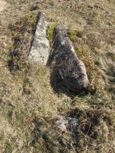
Brockhill Ford Ring Setting Cairn and Cist
OS Map: SX 67809 65702
HER: MDV5234
Megalithic Portal: 705
PMD: Brockhill Ford
Alternate name: Brockhill Ford W. Ring Setting Cairn and Cist
ShortName: CT Brockhill
Butler map: 57.18
DPD page: 88
Grinsell: DEA 2
Turner: D3
Barrow Report: 68
Notes: "The side stones, both 1.4m long, lean inwards and the end stones north west 0.7m long, southeast 0.8m long, are firmly set. The probable coverstone, 1.2m by 0.8m, is displaced and lies to the south east of the cist. The cist is surrounded by the remains of a stone circle, long axis 8.8m, aligned with cist, short axis 7.2m. It is constructed of large slabs, up to 1.4m long with a single upright stone, 0.5m high, set contiguously in the north west arc. There are no visible remains of a cairn." Lethbridge p.88 photo (note the diagram is not related). See also: Huntingdon cross walk. Butler Brockhill Ford W. - Vol. 4. Map 57.18 (pp.151-2 diagram p.152).
Nearby sites: SX 67809 65702
Distance: 0.88km
Buckland Ford Cairn Circle
OS Map: SX 6574 6604
HER: MDV5187
Megalithic Portal: 717
ShortName: CC:Buckland Fd
Butler map: 57.23
DPD page: 87
Grinsell: LYD 107
Turner: G19
Barrow Report: 65
Notes: Probable cairn circle. "A small, probably sepulchral, stone circle. It consists of 14 stones arranged in an 'egg' shape. The long axis is 9.9 metres aligned due east by 8.2m transversely. A further 7 stones are in close proximity but may not be associated. There is no trace of a cist or cairn." "It is largely obscured by long tussocky grass and the absence of a discernible cairn or cist makes it an unusual site by Dartmoor standards".
Nearby sites: SX 6574 6604
Distance: 1.30km
Dean Moor Enclosed Settlement
OS Map: SX 67741 65458
HER: MDV14799
Megalithic Portal: 45324
ShortName: ES Dean Moor
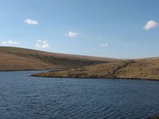
Notes: Enclosed settlement on Dean Moor, excavated between 1954 and 1956, prior to construction of the reservoir. Prehistoric walled enclosure containing at least 13 huts together with pens. Parallels have been drawn with the settlement at Kestor. Part of the prehistoric settlement was incorporated into a medieval farmstead (see HER record 14221). Part of site now flooded by Avon Reservoir.
Nearby sites: SX 67741 65458
Distance: 0.80km
Eastern White Barrow (The Submarine) Cairn
OS Map: SX 66550 65168
HER: MDV5184
Megalithic Portal: 45572
Alternate name: Eastern White Barrow Cairn
ShortName: CN:E White Bar
Butler map: 57.27
DPD page: 86
Grinsell: BRE 1
Notes: Also known as the Eastern Whittabarrow or Whittaburrow. "A large, round, flat topped cairn measuring 26m in diameter and 3.5m high. It is surmounted by a modern, drum-shaped, marker cairn of 4.5m diameter and 2m high. Known as The Submarine due to its appearance in profile on the horizon. See also Legendary Dartmoor: The Submarine
Nearby sites: SX 66550 65168
Distance: 0.55km
Gripper's Hill Enclosed Settlement
OS Map: SX 68156 64874
HER: MDV5742
Megalithic Portal: 45320
ShortName: ES Grippers
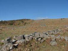
Notes: "A Bronze Age pastoral settlement on Gripper's Hill, Dean Prior, was excavated in July 1954 by Lady Aileen Fox on behalf of the Ministry of Works. The site comprises four enclosures containing ten or more huts."
Nearby sites: SX 68156 64874
Distance: 1.39km
Gripper's Hill Stone Ring Cairn Circle
OS Map: SX 68650 65503
HER: MDV5224
Megalithic Portal: 45822
Alternate name: Gripper's Hill Summit 1 Stone Ring Cairn Circle
ShortName: RC Grippers
Butler map: 57.31.1
Grinsell: DEA 4
Turner: A9
Notes: "Ring cairn on Gripper's Hill; stone ring 14.0 metres in diameter internally, with bank 1.2 meters wide and 0.3 meters high." NMR A
Nearby sites: SX 68650 65503
Distance: 1.71km
Huntingdon Barrow Cairn
OS Map: SX 66217 66912
HER: MDV5235
Megalithic Portal: 45571
Alternate name: Heap of Sinners Cairn
ShortName: CN:Huntingdon
Butler map: 58.14
DPD page: 87
Grinsell: LYD 103
Barrow Report: 65
Notes: On the highest part of Huntingdon Hill is a fine cairn 76 yards (approximately 70 meters) in circumference usually known as Huntingdon barrow but sometimes referred to as the Heap O' Sinners.
Nearby sites: SX 66217 66912
Distance: 1.54km
Inner Pupers Stone Ring Cairn Circle
OS Map: SX 67566 67421
HER: MDV13205
Megalithic Portal: 45847
PMD: Inner Pupers
Alternate name: Inner Puper's Stone Ring Cairn Circle
ShortName: RC:InnerPupers
Butler map: 58.9
DPD page: 89
Grinsell: BUC 6
Turner: A60
Notes: "The rock outcrop known as Inner Pupers is encompassed by a cairn of 13.0 meters overall diameter. It takes the shape of a platform 0.4 meters high around the rock, with a rim 1.5 meters wide and a further 0.4 meters high. Of small stones, with further 'natural' slabs protrude through."
Nearby sites: SX 67566 67421
Distance: 1.97km
Knatta Barrow Stone Ring Cairn Circle
OS Map: SX 65970 64212
HER: MDV5717
Megalithic Portal: 45842
ShortName: RC:Knatta Bar.
Butler map: 57.29
Butler Vol 5: p.160 & Fig.102
Grinsell: BRE 2
Turner: A54
Notes: "This large cairn (24m diameter, 1.7m height) composed of loose granite boulders. It is unusual among summit cairns in having a well defined outer bank about 1m wide and 0.5m high. This is partly turf covered but where eroded can be seen to be built of loose stone like the central cairn which touches it. It shows best on the north and east sides, while on the south west side it tends to merge into the body of the cairn."
Nearby sites: SX 65970 64212
Distance: 1.66km
Pupers Rock Stone Ring Cairn Circle
OS Map: SX 67281 67376
HER: MDV5219
Megalithic Portal: 45845
Alternate name: Puper's Hill Summit Stone Ring Cairn Circle
ShortName: RC:Pupers Rock
Butler map: 58.9
DPD page: 89
Grinsell: DEA 1
Turner: A58
Notes: "Ring cairn incorporating a large flat-topped granite outcrop. The stone ring measures 17 meters in diameter internally with 2.5 meter wide bank 0.6 meters high. There are the remains of a stone circle, around 1.0 meter high within the outcrop."
Nearby sites: SX 67281 67376
Distance: 1.85km
Riders Rings Enclosed Settlement
OS Map: SX 67870 64359
HER: MDV5767
Megalithic Portal: 45321
ShortName: ES RidersRings
DPD page: 85
Notes: "The largest and most important pound in the Avon Valley. Situated on the eastern slope of Zeal Plains. It is best regarded as being two contiguous pounds, of which it would appear that the south west member was constructed first, while the north east member was added as a later extension. The two pounds together cover an area of over six acres and enclose some three dozen hut-circles". Lethbridge p.85
Nearby sites: SX 67870 64359
Distance: 1.51km
Western White Barrow Cairn
OS Map: SX 65363 65487
HER: MDV5193
Megalithic Portal: 28710
ShortName: CN:W White Bar
Butler map: 57.28
DPD page: 86
Grinsell: LYD 104
Notes: Western Whittabarrow or Whittaburrow. "A large cairn measuring 21 by 17.5 metres wide with a maximum height of 1.7 metres. It has been badly mutilated by the construction of a two room building within it."
Nearby sites: SX 65363 65487
Distance: 1.58km