
Prehistoric sites within 5km of SX 69033 92542
Guidance for walkers: The monuments featured in this database are archaeological treasures and need to be protected and preserved - please do not disturb any sites. Please check access and firing times before visiting sites, not all sites listed are on open access land. Firing ranges and boundaries of open access areas are marked on the OL28 OS Dartmoor Explorer map. Please stick to the country code and consider giving support to the numerous agencies that help to keep Dartmoor a fabulous natural and historic environment!
About the database listings: In all listings clicking on the photo or the site name will open a page for the site with a larger photo and further details from the database. The database now has over 6680 records covering nearly all publicly listed sites on Dartmoor including around 4800 round houses. This level of detail is of interest to archaeologists but tends to swamp listings of sites more likely to be of interest for walkers. For this reason, the listings default to around 550 core sites only. These are the stone circles, stone rows and the ring cairns listed by Turner. The default search radius is 2 km. The controls below the map can be used to start a new search by entering a 6- or 8-digit reference (without the prefix "SX"). The search radius can be specified and you can add incremental Display layers of detail on top of the core sites. If using a more detailed layer you will need to decrease the search radius to avoid getting hundreds of search results.
- Core sites Default listing of core sites consisting of stone circles & rows and some of the major ring cairns.
- Plus cairns adds approx. 1000 cairns and other minor sites not included in the core listings but excluding round houses.
- Plus round houses adds approx. 4800 round houses.
- Plus non-sites adds in the records for sites that no longer exist or are not prehistoric sites.
- Plus duplicates adds records excluded as duplicates. Those maybe duplicate records in external listings (e.g. the Historic Environment Records). For example, some sites have been identified as cairns in some listings and interpreted as round houses in other listings and both records appear.
These listings have incorporated, matched up and merged all of the records from all of the major archaeological listings including: Worth, Grinsell, Turner, Butler, Bill Radcliffe, Sandy Gerrard, Megalithic Portal, the National Monument Records and the Historic Environment Records. The author would like to thank Bill, Sandy, the lovely people both at Megalithic Portal (especially Anne Tate who did an amazing job to link listings) and at ACE Archaeology for collaborative work over the years to synchronise and correct listings across the various websites which now interlink. A culmination of years of work the final merger of cairn records took 3 months of cross referencing in 2017 the result being a snapshot of the records at that time. This data has in turn been refined since by field work and research. The round house data was supplied by Sandy Gerrard. Grid references are in order of accuracy: from Google Earth satellite, if visible and found, from a Garmin GPS reading, if visited by the author and from the literature otherwise. Individual site pages will state the source of the grid reference and provide satellite imagery. If a site listing lacks a photo it has not yet been visited by the author in which case the grid reference is from the literature.
Currently the database only includes sites which can be represented by a grid reference. Reaves are not included as they require GIS shape technology which is beyond the current capability of this system. To see the sources for the records, look at the tables on the resources menu. The database listings can also be viewed on a Google map and downloaded as GPS datasets for Garmin devices.
Corrections, or any feedback or suggestions are very welcome, email: info@dartmoorwalks.org.uk.
NOTE: Clicking on the icons for each monument in the map will give the name of the site. You can zoom in and out and drag the map around.
List of sites within 5km of SX 69033 92542
Throwleigh Common 6 Platform Cairn Circle and Cist
OS Map: SX 65203 89798
HER: MDV13020
PMD: Forder Brook
ShortName: CT:Throw 6
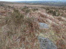
Notes: Round cairn. Diameter 6.4 metres, height 1 metre. Cist 0.6 metres wide, oriented north-south. Central pit 1.5 metres by 1.1 metres by 0.25 meters deep. Situated on downslope edge of a natural terrace. Three edge set stones lying parallel to each other are exposed in the central pit. The two eastern ones may represent the edges of a cist with a length or width of 0.6 metres. A number of edge set stones around the edge represent a kerb. Gorse covered. NOTE: NMR gives location as SX 6519 8978.
The overgrown feature in the photo from 17/03/2025 is possibly this feature but it is a considerable distance from the NMR grid reference. That is located at SX 65203 89798
Nearby sites: SX 65203 89798
Distance: 4.71km
Shilley Pool N. Cairn Circle
OS Map: SX 6503 9142
HER: MDV6945
PMD: Shilley Pool N.
ShortName: CN:ShilleyPool
Butler map: 39.6
Grinsell: ST 5a
Notes: Mound, possibly a barrow, shown on os 6" as 'mound', on 1:25000 os as 'tumulus'.
Nearby sites: SX 6503 9142
Distance: 4.16km
Buttern Hill 4 Cairn Circle
OS Map: SX 6540 8949
HER: MDV13021
ShortName: CC:Buttern 4
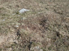
Notes: HER: A small cairn circle situated at SX 65408949 in open moorland immediately below the crest of a broad topped spur at about 1300 ft OD. It has a diameter of 6.0m and consists of 13 turf-fast stones; three are recumbent, one stands to a height of 0.4m, and the remainder barely protrude through the turf.
Nearby sites: SX 6540 8949
Distance: 4.74km
Throwleigh Common 1 Cairn
OS Map: SX 6542 9067
HER: MDV59305
ShortName: CN:Throw 1
Butler map: 39.1.1
Notes: HER: Northern of five cairns of 7.5 metres diameter by 0.5 metres high to the west of the settlement on Throwleigh Common
Nearby sites: SX 6542 9067
Distance: 4.07km
Blackaton Brook 1 Cairn
OS Map: SX 64545 90378
HER: MDV59576
PMD: Blackaton Brook
ShortName: CT:Blackaton 1
Notes: The monument includes a cairn cemetery and sinuous linear earthwork bank situated on a gentle east facing slope overlooking the valley of the Blackaton Brook. The cairn cemetery survives as a linear cluster of six mounds standing between 0.6m and 1.3m high. Three of the mounds are circular in shape with their diameters varying between 4.5m and 8m. The remainder are oval with lengths between 5.5m and 13m. Four of the mounds have been robbed or partially excavated and an edge set stone in the centre of the northern cairn may represent the remnants of a cist.
Nearby sites: SX 64545 90378
Distance: 4.98km
Cosdon Hill East 1 Cairn
OS Map: SX 6488 9181
HER: MDV59590
ShortName: CN:CosdonE 1
Nearby sites: SX 6488 9181
Distance: 4.22km
Cosdon Hill East 2 Cairn
OS Map: SX 6489 9183
HER: MDV59591
ShortName: CN:CosdonE 2
Nearby sites: SX 6489 9183
Distance: 4.20km
Cosdon Hill East 3 Cairn
OS Map: SX 6490 9184
HER: MDV59592
ShortName: CN:CosdonE 3
Nearby sites: SX 6490 9184
Distance: 4.19km
Cosdon Hill East 4 Cairn
OS Map: SX 6491 9186
HER: MDV59593
ShortName: CN:CosdonE 4
Nearby sites: SX 6491 9186
Distance: 4.18km
Cosdon Hill East 5 Cairn
OS Map: SX 6491 9184
HER: MDV59594
ShortName: CN:CosdonE 5
Nearby sites: SX 6491 9184
Distance: 4.18km
Cosdon Hill East 6 Cairn
OS Map: SX 6491 9181
HER: MDV59595
ShortName: CN:CosdonE 6
Nearby sites: SX 6491 9181
Distance: 4.19km
Cosdon Hill East 7 Cairn
OS Map: SX 6491 9182
HER: MDV59596
ShortName: CN:CosdonE 7
Nearby sites: SX 6491 9182
Distance: 4.19km
Cosdon Hill East 8 Cairn
OS Map: SX 6493 9179
HER: MDV59597
ShortName: CN:CosdonE 8
Nearby sites: SX 6493 9179
Distance: 4.17km
Cosdon Hill East 9 Cairn
OS Map: SX 6493 9183
HER: MDV59598
ShortName: CN:CosdonE 9
Nearby sites: SX 6493 9183
Distance: 4.16km
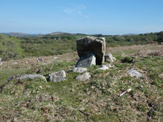
Throwleigh Chambered Cairn
OS Map: SX 65153 89768
HER: MDV13022
ShortName: NT:Throwleigh
Notes: HER: Megalithic granite stone of 1.3 metres high by 1 metre wide and 0.3 metres thick may possibly be the remains of a burial chamber. Two 'Standing Stones' are shown on modern mapping.. The NGR used on the this record is 20m to the north of the HER entry based on Google satellite imagery.
Nearby sites: SX 65153 89768
Distance: 4.77km
Throwleigh Common 3 Clearance Cairn
OS Map: SX 6546 9055
HER: MDV59307
ShortName: CN?Throw 3
Butler map: 39.1.3
Notes: Clearance cairn within reave system.
Nearby sites: SX 6546 9055
Distance: 4.09km
Throwleigh Common 4 Clearance Cairn
OS Map: SX 6546 9056
HER: MDV59307
ShortName: CN?Throw 4
Butler map: 39.1.4
Notes: Clearance cairn within reave system.
Nearby sites: SX 6546 9056
Distance: 4.09km
Throwleigh Common 5 Clearance Cairn
OS Map: SX 6554 9044
HER: MDV134156
ShortName: CN?Throw 5
Butler map: 39.1.5
Notes: HER reffering to Butler: Throwleigh Common cairn '5' of 7.4 metres diameter by 0.3 metres high. On the other side of the hill, out of sight of the settlement on Trowleigh Common but still within its boundaries, is a cairn cemetery which may well have been the burial ground for the hut dwellers. This southern cairn is located in a square field on the north side of the 'leat' to the west of the settlement.
Nearby sites: SX 6554 9044
Distance: 4.08km
Throwleigh East 1 Clearance Cairn
OS Map: SX 6510 8983
HER: MDV59333
ShortName: CN:ThrowE 1
Notes: HER: Possible cairn of 8.3 metres diameter by 1 metre high on the east slope of Kennon Hill with a central pit of 1.5 metres by 0.9 metres by 0.5 metres deep
Nearby sites: SX 6510 8983
Distance: 4.78km
Throwleigh East 2 Clearance Cairn
OS Map: SX 6506 8999
HER: MDV59334
ShortName: CN:ThrowE 2
Notes: HER: Clearance cairn of 2.5 metres by 2.3 metres by 0.6 metres high on the eastern slope of Kennon Hill
Nearby sites: SX 6506 8999
Distance: 4.72km
Throwleigh East 3 Clearance Cairn
OS Map: SX 6507 9000
HER: MDV59335
ShortName: CN:ThrowE 3
Notes: HER: Clearance cairn of 9.5 metres by 3.5 metres by 0.7 metres high on the eastern slope of Kennon Hill. May have originally been built as part of an agglomerated enclosure which was never completed.
Nearby sites: SX 6507 9000
Distance: 4.71km
Throwleigh East 4 Clearance Cairn
OS Map: SX 6506 9002
HER: MDV59336
ShortName: CN:ThrowE 4
Notes: HER: Clearance cairn of 5.5 metres by 3 metres by 0.5 metres high on the eastern slope of Kennon Hill
Nearby sites: SX 6506 9002
Distance: 4.71km
Throwleigh East 5 Clearance Cairn
OS Map: SX 6508 9002
HER: MDV59337
ShortName: CN:ThrowE 5
Notes: HER: Clearance cairn of 4 metres by 2 metres by 0.4 metres high on the eastern slope of Kennon Hill
Nearby sites: SX 6508 9002
Distance: 4.69km
Throwleigh East 6 Clearance Cairn
OS Map: SX 6509 9002
HER: MDV59338
ShortName: CN:ThrowE 6
Notes: HER: Clearance cairn of 10 metres by 3 metres by 0.6 metres high on the eastern slope of Kennon Hill. May have originally been built as part of an agglomerated enclosure which was never completed.
Nearby sites: SX 6509 9002
Distance: 4.68km
Throwleigh East 7 Clearance Cairn
OS Map: SX 6508 9004
HER: MDV59339
ShortName: CN:ThrowE 7
Notes: HER: Clearance cairn of 5 metres by 3 metres by 0.7 metres high on the eastern slope of Kennon Hill
Nearby sites: SX 6508 9004
Distance: 4.68km
Throwleigh East 8 Clearance Cairn
OS Map: SX 6509 9004
HER: MDV59340
ShortName: CN:ThrowE 8
Notes: HER: Clearance cairn of 6 metres by 1.8 metres by 0.7 metres high on the eastern slope of Kennon Hill
Nearby sites: SX 6509 9004
Distance: 4.67km
Throwleigh East 9 Clearance Cairn
OS Map: SX 6505 9006
HER: MDV59341
ShortName: CN:ThrowE 9
Notes: HER: Clearance cairn of 3 metres diameter by 0.5 metres high on the eastern slope of Kennon Hill
Nearby sites: SX 6505 9006
Distance: 4.69km
Throwleigh East 10 Clearance Cairn
OS Map: SX 6506 9005
HER: MDV59342
ShortName: CN:ThrowE10
Notes: HER: Clearance cairn of 13 metres by 4 metres by 0.7 metres high on the eastern slope of Kennon Hill. May have originally been built as part of an agglomerated enclosure which was never completed.
Nearby sites: SX 6506 9005
Distance: 4.69km
Throwleigh East 11 Clearance Cairn
OS Map: SX 6508 9006
HER: MDV59343
ShortName: CN:ThrowE11
Notes: HER: Clearance cairn of 16 metres by 4 metres by 0.9 metres high on the eastern slope of Kennon Hill. May have originally been built as part of an agglomerated enclosure which was never completed.
Nearby sites: SX 6508 9006
Distance: 4.67km
Buttern Hill 6 Clearance Cairn
OS Map: SX 6565 8917
HER: MDV103612
ShortName: CN:Buttern 6
Nearby sites: SX 6565 8917
Distance: 4.78km
Throwleigh Common 2 Reported Cairn
OS Map: SX 6541 9053
HER: MDV59307
ShortName: CN:Throw 2
Butler map: 39.1.2
Notes: See: 1476178
Nearby sites: SX 6541 9053
Distance: 4.14km
West Wyke 2 Reported Cairn
OS Map: SX 6572 9280
HER: MDV13068
ShortName: CN?WestWyke 2
Nearby sites: SX 6572 9280
Distance: 3.32km
Throwleigh East M Cairnfield Master
OS Map: SX 65070 90010
ShortName: CN:ThrowE M
Notes: There are 11 clearance cairns in very close proximity to each other listed on the HER. This record has been added as a master record and hence set as a duplicate. See the individual records.
Nearby sites: SX 65070 90010
Distance: 4.70km
Shilley Pool W Cairnfield Master
OS Map: SX 648 913
HER: MDV60365
ShortName: CN:ShilleyPl W
Notes: HER: Bronze Age cairnfield consisting of at least 25 cairns between 0.4 metres and 0.8 metres high. Of these 14 are circular with diameters of between 3 metres and 6.9 metres. The remainder are ovoid and vary form 4 metres and 10.2 metres long. One cairn has a kerb of edge set stones this is probably a funerary round cairn. It is surrounded by a 1.5 metre wide 0.3 metre high platform. It has been damaged by robbing or early excavation.
Nearby sites: SX 648 913
Distance: 4.41km
Cosdon Hill East Cairnfield Master
OS Map: SX 6489 9182
HER: MDV59589
ShortName: CN:CosdonE M
Nearby sites: SX 6489 9182
Distance: 4.21km
Blackaton Brook Reported Stone Row
OS Map: SX 648 908
ShortName: SR:Blackaton
Notes: Breton p.53 To the N. of it [Breton is referring to the Cosdon Triple row] are clitters of rocks, a short distance to the S, a swamp in which a feeder of the Blackaton Brook rises. On its E. slopes are the remains of a stone row. The feeder referred to is the Cheriton Comb which passes a boggy area. This would place the row at approximately SX 648 908. There is no known stone row at this point and this author is unaware of other accounts. This section of the Blackaton Brook has been greatly disturbed by stream workings.
Nearby sites: SX 648 908
Distance: 4.58km
Buttern Hill Enclosed Settlement
OS Map: SX 65501 89146
HER: MDV6140
Megalithic Portal: 25242
ShortName: ES:ButternHill
Nearby sites: SX 65501 89146
Distance: 4.90km
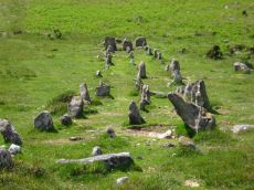
Cosdon Stone Row
Prehistoric Dartmoor Walks: Dartmoor Site: Cosdon Hill Triple Stone Row
OS Map: SX 64317 91600
HER: MDV6886
Megalithic Portal: 1858
The Stone Rows of GB: Cosdon
PMD: Cosdon Stone Row
ShortName: SR Cosdon
Butler map: 40.6
DPD page: 152
Notes: "A triple stone row lies near the summit of Cosdon Hill and is 447 feet in length measured from the centre of the circled cairn which stands at the west end. At 225 feet from the west end there is a slight change in direction and the rows turn somewhat northward. This change of direction may be said to divide the row into western and an eastern section. Overall width, western part is 8 feet 10 inches, eastern part 10 feet 8 inches. The cairn is 26 feet in diameter and contains the remains of two cists; the retaining circle is very irregular. There is no formal feature to mark the termination of the rows at their eastern end"
Nearby sites: SX 64317 91600
Distance: 4.81km
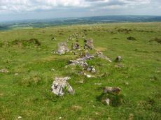
Cosdon (stone row) Platform Cairn Circle and Cist
Prehistoric Dartmoor Walks: Dartmoor Site: Cosdon Hill Triple Stone Row
OS Map: SX 64331 91597
HER: MDV48906
Megalithic Portal: 813
PMD: Cosdon Stone Row
Alternate name: Cosdon Hill Stone Row Platform Cairn Circle and Cist
ShortName: CT Cosdon Row
Butler map: 40.6
Butler Vol 5: p.234 & Fig.165
DPD page: 152
Grinsell: ST 5
Turner: E15
Notes: "The cairn associated with the Cosdon Hill triple stone row is 26 feet in diameter and contains the remains of two cists; the retaining circle is very irregular. Of the two cists, one is intact, the other has been robbed of the cover-stone and two side-stones." Lethbridge diagram p.152, cists pictured. Butler Cosdon Hill Stone Row - Vol. 2. Map 40.6 (diagram p.205).
Nearby sites: SX 64331 91597
Distance: 4.80km
Eight Rocks (site of) Reported Stone Circle
OS Map: SX 645 925
HER: MDV7395
ShortName: SCxEight Rocks
Notes: "Site of a stone circle, since destroyed, originally thought to have been located somewhere between Cosdon Hill and Ford Farm, South Tawton. Nothing remains today; the circle was apparently robbed out in the later 19th century by men from Ramsley Copper Mine, South Zeal."
Nearby sites: SX 645 925
Distance: 4.53km
Gidleigh - North Chambered Tomb
OS Map: SX 65867 88956
HER: MDV6212
Megalithic Portal: 45581
PMD: Gidleigh North Chambered Cairn
Alternate name: Buttern Hill 2 Chambered Tomb
ShortName: NT Gidleigh N
Butler map: 38.7.2
Butler Vol 5: p.157
Grinsell: A:GID 1
Notes: "A chambered cairn located on an east facing slope of Buttern Hill. The cairn mound measures 26 metres long and 9 metres wide and stands up to 1 metre high. Several set stones at the western end of the mound represent the remains of a passage leading towards a chamber."
Nearby sites: SX 65867 88956
Distance: 4.78km
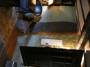
Oxenham Arms Standing Stone
Prehistoric Dartmoor Walks: Dartmoor Site: The Oxenham Arms standing stones
OS Map: SX 65014 93606
HER: MDV13065
Megalithic Portal: 8401
PMD: Oxenham Arms
ShortName: SS OxenhamArms
Notes: "The Oxenham Arms, now an inn, is the former manor house and home of the Burgoyne family. A courtyard plan house, it was originally a two-room-and-through passage plan. An interesting feature is an enormous upright slab of granite built into the inner wall of the rear parlour. This looks very much like a prehistoric standing stone and it seems that the house was built around it".
Nearby sites: SX 65014 93606
Distance: 4.16km
Shilstone Common (DRE 1a) Cairn Circle
Prehistoric Dartmoor Walks: Dartmoor Site: Shilstone Common & Spinsters' Rock
OS Map: SX 699 908
HER: MDV7010
Megalithic Portal: 44557
The Stone Rows of GB: Spinsters Rock
PMD: Spinster's Rock Cairns and Stone Rows
Alternate name: Shilstone Common 1 Cairn Circle
ShortName: CC:Shilstone A
Butler Vol 5: p.218
Grinsell: B:DRE 1a
Notes: Former remains on Shilstone Common near Spinsters rock. Remains no longer visible. Possibly sketched by Rev. John Swete in 1789. Site controversially mapped by Rev. William Grey in 1838 and published by Ormerod in 1872. Site dismissed by R.H. Worth but probable cairn remains found during field excavations by Major F.C. Tyler in 1930. For a reappraisal of Tyler's report see coverage on Prehistoric Dartmoor Walks.
Nearby sites: SX 699 908
Distance: 1.95km
Shilstone Common (DRE 1b) Cairn Circle
Prehistoric Dartmoor Walks: Dartmoor Site: Shilstone Common & Spinsters' Rock
OS Map: SX 6995 9080
HER: MDV7010
Megalithic Portal: 44557
Alternate name: Shilstone Common 2 Cairn Circle
ShortName: CC:Shilstone B
Butler Vol 5: p.218
Grinsell: B:DRE 1b
Notes: Former remains on Shilstone Common near Spinsters rock. See Site 95 notes (B:DRE 1a)
Nearby sites: SX 6995 9080
Distance: 1.97km
Shilstone Common (DRE 1c) Cairn Circle
Prehistoric Dartmoor Walks: Dartmoor Site: Shilstone Common & Spinsters' Rock
OS Map: SX 7000 9055
HER: MDV7010
Megalithic Portal: 44557
Alternate name: Shilstone Common 3 Cairn Circle
ShortName: CC:Shilstone C
Butler Vol 5: p.218
Grinsell: B:DRE 1c
Notes: Former remains on Shilstone Common near Spinsters rock. See Site 95 notes (B:DRE 1a)
Nearby sites: SX 7000 9055
Distance: 2.21km
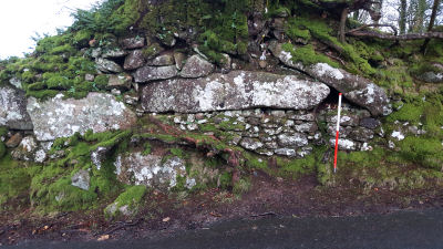
Shilstone Lane Reported Cairn
OS Map: SX 65955 90139
ShortName: CN-Shilstone
Notes: This record arose from a posting by Clive Darke on a Dartmoor Facebook forum. Clive posted a photo of this feature on the side of the road and asked whether it could perhaps be a re-used menhir in a Devon wall.
Nearby sites: SX 65955 90139
Distance: 3.90km
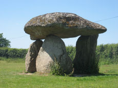
Spinsters Rock Chambered Tomb
Prehistoric Dartmoor Walks: Dartmoor Site: Spinsters' Rock
OS Map: SX 70098 90789
HER: MDV8440
Megalithic Portal: 149
PMD: Spinsters Rock
ShortName: NT Spinsters
Butler Vol 5: p.155
DPD page: 150
Grinsell: A:DREW 1
Barrow Report: 56
Notes: Chambered tomb restored in 1862. No evidence to confirm or deny the existence of an original mound survives. The remains of the chamber consist of three granite orthostats 6 to 9 1/2 feet high which support a large capstone 14 1/2 feet long by 10 feet wide. No trace of any mound survives. It is associated with the nearby stones thought to have been circles and alignments (SX 69 SE 25) (see Shilstone Common & Spinster's Rock page).
Nearby sites: SX 70098 90789
Distance: 2.05km