
Blackaton Brook Reported Stone Row
The Heart of Dartmoor, (1926) p.53
Database entries
OS Map: SX 648 908
OS Source: Estimate
Alternate name: Blackaton Brook
Short Name: SR:Blackaton
Exist: Maybe
Record: Unique
Record Source: Breton
Hut Class: No
Lidar: SX 648 908
Guide Map: 3
Nearest Bus Stop (Minor): Throwleigh Cross (2.7 km) [Route: 670]
Nearest Bus Stop (Major): Ramsley (2.4 km) [Route: 670,671,6A]
Nearby sites: SX 648 908
Notes
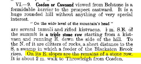
Breton p.53 To the N. of it [Breton is referring to the Cosdon Triple row] are clitters of rocks, a short distance to the S, a swamp in which a feeder of the Blackaton Brook rises. On its E. slopes are the remains of a stone row. The feeder referred to is the Cheriton Comb which passes a boggy area. This would place the row at approximately SX 648 908. There is no known stone row at this point and this author is unaware of other accounts. This section of the Blackaton Brook has been greatly disturbed by stream workings.References
These are selected references with an emphasis on out of copyright sources linked as PDFs. For more detailed references try any linked HER or PMD record above.
- Breton, Henry Hugh, The Heart of Dartmoor, (1926)