
Guide to the Monuments on Rippon Tor
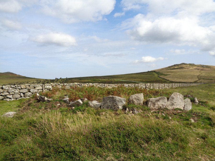
Table of Ritual and Burial Monuments on Rippon Tor
The following table lists the records currently in this Guide Map. For an explantion of the Guide Maps and a table of all 62 Guide Maps, follow this link: Guide List Table. Introductory text will be added to each guide list in 2025. Notes on duplication and omissions will appear below the table once checks have been finalised.
Rippon Tor Guide Map
Guidance for walkers: The monuments featured in this database are archaeological treasures and need to be protected and preserved - please do not disturb any sites. Please check access and firing times before visiting sites, not all sites listed are on open access land. Firing ranges and boundaries of open access areas are marked on the OL28 OS Dartmoor Explorer map. Please stick to the country code and consider giving support to the numerous agencies that help to keep Dartmoor a fabulous natural and historic environment!
List of Ritual and Burial Monuments on Rippon Tor
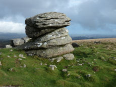
Hay Tor S.E.1 Cairn
OS Map: SX 76265 76521
HER record: MDV103592
ShortName: CN:Hay Tor 1
Butler map: 4.4
Notes: A once substantial cairn of 22 metres diameter. The fabric has been heavily robbed though traces of a kerb survive.
Nearby sites: SX76277652
Hay Tor S.E.2 Cairn
OS Map: SX 76181 76543
HER record: MDV103591
ShortName: CN:Hay Tor 2
Notes: Prehistoric cairn which has been badly disturbed and robbed lies on the southern ridge of Haytor Down - one of a group of four
Nearby sites: SX76187654
Hay Tor S.E.3 Cairn
OS Map: SX 76098 76550
HER record: MDV103590
ShortName: CN:Hay Tor 3
Notes: "A badly disturbed Prehistoric cairn on the southern ridge of Haytor Down - one of a group of four."
Nearby sites: SX76107655
Hay Tor S.E.4 Cairn
OS Map: SX 76030 76598
HER record: MDV103589
ShortName: CN:Hay Tor 4
Notes: A badly robbed out cairn on the southern ridge of Haytor Down - one of a group of four.
Nearby sites: SX76037660
Hay Tor S.E.5 Cairn
OS Map: SX 76861 75925
HER record: MDV19471
ShortName: CN:Hay Tor 5
Nearby sites: SX76867593
Hay Tor S.E.6 Reported Cairn
OS Map: SX 77450 76300
HER record: MDV26588
ShortName: CNxHay Tor 6
Nearby sites: SX77457630
Hayter S. Cairn
OS Map: SX 75631 76810
HER record: MDV40740
ShortName: CN:Hayter S.1
Butler map: 1.8
Notes: HER: Prehistoric cairn to the south of Haytor Rocks. The cairn consists of a low earth mound of 8.7m diameter and 0.5m high on average. It has a flattish top with a 1.5m by 0.5m deep depression, set just off centre, marking the site of an unrecorded excavation. This cairn is probably part of a ridge top alignment.
Nearby sites: SX75637681
Emsworthy Rocks E.1 Cairn
OS Map: SX 75280 76820
HER record: MDV78669
ShortName: CN:Emsworthy 1
Butler map: 1.9.1
Notes: HER refers to two cairns
Nearby sites: SX75287682
Emsworthy Rocks E.2 Cairn
OS Map: SX 75330 76840
HER record: MDV78669
ShortName: CN:Emsworthy 2
Butler map: 1.9.2
Notes: HER refers to two cairns
Nearby sites: SX75337684
Saddle Tor A Ancient Pool
OS Map: SX 75135 76534
HER record: MDV127219
ShortName: PO:SaddleTorA
Notes: "A pool measuring 20m. One of over 40 such 'sacred' pools identified on Dartmoor that are thought to have potentially been designed during the prehistoric period. One of a group of three pools north-east of saddle Tor."
Nearby sites: SX75147653
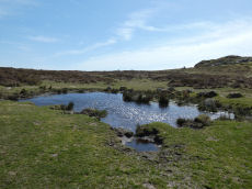
Saddle Tor B Ancient Pool
OS Map: SX 75172 76553
HER record: MDV127220
ShortName: PO:SaddleTorB
Notes: "A pool measuring 16.5 by 14.5m. One of over 40 such 'sacred' pools identified on Dartmoor that are thought to have potentially been designed during the prehistoric period. One of a group of three pools north-east of saddle Tor."
Nearby sites: SX75177655
Saddle Tor C Ancient Pool
OS Map: SX 75273 76526
HER record: MDV127222
ShortName: PO:SaddleTorC
Notes: "A pool measuring 14 by 10m. One of over 40 such 'sacred' pools identified on Dartmoor that are thought to have potentially been designed during the prehistoric period. One of a group of three pools north-east of saddle Tor."
Nearby sites: SX75277653
Saddle Tor Reported Cairn
OS Map: SX 75154 76343
HER: No record found
ShortName: CN?SaddleTor1
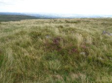
Notes: Mound where flag-pole was sited. This site was asked about by Max Piper on a Dartmoor Facebook group on 20 Nov 2020. Max observed: atop Saddle Tor's eastern mass at SX 75154 76343, and at the very, very top. It appears to have utilised bedrock and is almost a ring cairn on the western side where broken rocks have been piled up. In the discussion that followed the consensus was that there had once been a flag pole sited here and that is the origin of this man-made mound. It is being added here as a "reported cairn" to help others trying to make sense of it. Thanks to Max for the grid reference and details. There are no entries on the HER for this feature.
Nearby sites: SX75157634
Saddle Tor Crop Mark
OS Map: SX 75100 76500
HER record: MDV28309
ShortName: CNxSaddleTor2
Notes: Aerial Photograph
Nearby sites: SX75107650
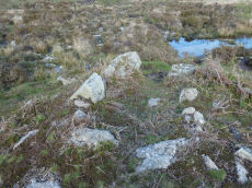
Haytor Chambered Tomb
OS Map: SX 75766 76409
HER record: MDV61778
ShortName: CN HaytorTomb
Butler map: 1.f
Butler Vol 5: p.158 & Fig.97
Notes: Haytor chambered tomb to the west of the Haytor track. Circular mound circa 4 metres diameter surrounds a rectangular chamber, circa 3 metres by 1.4 metres, tapering slightly towards one end, partially filled with soil. One of pair of larger slabs at entrance on downhill edge of mound has collapsed inwards, the other stands circa 1 metre above interior. Most of slabs forming sides of chamber appear in place but capstones have been removed. Entrance oriented south of east.
Nearby sites: SX75777641
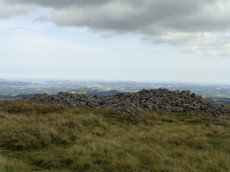
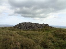
Rippon Tor Cairn
OS Map: SX 74664 75581
HER record: MDV7539
Megalithic Portal: 17833
PMD: Rippon Tor Summit
Alternate name: Rippon Tor 1 Cairn
ShortName: CN RipponTor 1
Butler map: 5.5.1
Grinsell: ILS 1
Notes: HER: A massive cairn on the summit of Rippon Tor, 28 metres in diameter and 4 metres high. One of four cairns in the vicinity. It is an approximately circular mound of granite boulders, with an overall spread of 27 metres. The top has been much altered and added to, and the central area hollowed; there is also the more recent addition of an Ordnance Survey trig pillar within the hollow. Condition is declining due to frequent interference by the public.
Nearby sites: SX74667558
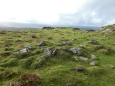
Rippon Tor 2 Stone Ring Cairn Circle
OS Map: SX 74677 75563
HER record: MDV51162
ShortName: RC RipponTor 2
Butler map: 5.5.2
Turner: A62
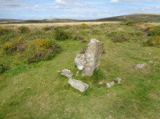
Notes: HER: A small cairn close to the tor which appears to have been a ring cairn surrounding a small free-standing granite outcrop. Butler: a small natural rock pillar about 2m high and 10m from C1, surrounded at the base by a ring of small stones (7.2 x 0.5 m) and, perhaps significantly, in line with the cairns.
Nearby sites: SX74687556
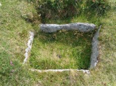
Rippon Tor 3 Reported Cist
OS Map: SX 74698 75537
HER record: MDV7434
PMD: Rippon Tor Summit
ShortName: CN RipponTor 3
Butler map: 5.5.3
Grinsell: ILS 2
Notes: NMR Cairn 'B' at SX 7474 7547 has been considerably mutilated in the eastern quadrant where it is barely 0.5m. high; otherwise it is up to 3.0m. high. Butler states "Composed of small stones except for a large slab lying at the edge, this is probably the site of the cist referred to by Crossing as almost covered by turf, though he makes no mention of the cairn.
Nearby sites: SX74707554
Rippon Tor 3 (duplicate) Reported Cairn
OS Map: SX 74680 75530
HER: No record found
PMD: Rippon Tor E.
ShortName: CT?RipponT Dup
Notes: Rippon Tor E. Duplicate of HER 7434. PMD: Stone setting round a possible central cist. 2.3m x 3.5m N-S. Very slight retaining bank 6.5m dia. Ring bank now under reave. Probably the same as SX 7468 7553.. This record originated in the now deleted HER record MDV51157. It is being kept here so there is a full listing of the entries on PMD - although that reference could be circular to this entry!
Nearby sites: SX74687553
Rippon Tor 4 Cairn
OS Map: SX 74724 75501
HER record: MDV13721
ShortName: CN RipponTor 4
Butler map: 5.5.4
Grinsell: ILS 3
Notes: HER: One of a pair of large cairns to the south-east of Rippon Tor. It is located on a reave but probably predates it. It is an amorphous and much disturbed cairn of 20 metres diameter, which, due to interference, now has an uneven profile.
Nearby sites: SX74727550
Rippon Tor 5 Cairn
OS Map: SX 74750 75479
HER record: MDV7433
ShortName: CN RipponTor 5
Butler map: 5.5.5
Grinsell: ILS 4
Notes: HER: One of a pair of large cairns south-east of Rippon Tor. It is located on a reave but probably predates it. A much spread and turf-covered cairn of up to 25 metres diameter, 87 metres south-east of Rippon Tor outcrop.
Nearby sites: SX74757548
Rippon Tor 6 Cairn
OS Map: SX 74667 75560
HER record: MDV51161
ShortName: CN RipponTor 6
Notes: HER: Small cairn south of Rippon Tor cairn and immediately contiguous to scatter from it. Diam 4.0 metres, height 0.45 metres.
Nearby sites: SX74677556
Rippon Tor 7 Clearance Cairn
OS Map: SX 74554 75384
HER record: MDV106805
ShortName: CN:RipponTor 7
Notes: HER: Low stony mound circa 1.5 metres diameter on the south-western slope of Rippon Tor
Nearby sites: SX74557538
Rippon Tor 8 Clearance Cairn
OS Map: SX 74491 75483
HER record: MDV106807
ShortName: CN:RipponTor 8
Notes: HER: Low stony mound about 1.5 metres diameter
Nearby sites: SX74497548
Lower Horridge 1 Cairn
OS Map: SX 75505 75151
HER record: MDV8100
ShortName: CN:Lower Hor1
Butler map: 5.6.1
Grinsell: ILS 7
Notes: HER: One of two round cairns on the northern sector of Horridge Common, survives as a turf-covered mound with a base diameter of 11 metres. Covered by gorse at time of 2015 survey.
Nearby sites: SX75517515
Lower Horridge 2 Cairn
OS Map: SX 75527 75127
HER record: MDV8101
ShortName: CN:Lower Hor2
Butler map: 5.6.2
Grinsell: ILS 8
Notes: HER: One of two round cairns on the northern sector of Horridge Common, survives as a turf-covered mound with a base diameter of 10 metres. Covered by gorse at time of 2015 survey.
Nearby sites: SX75537513
Bagtor Wood Reported Cairn
OS Map: SX 75830 74967
HER record: MDV62344
ShortName: CN?BagtorWood
Butler map: 4.3
Butler Vol 5: p.202 & Fig.146
Notes: Ruined hut or cairn at the centre of ovoid enclosure. Was obscured by vegetation at the time of the survey.
Nearby sites: SX75837497
Halsanger Clearance Cairn
OS Map: SX 74450 75220
HER record: MDV7548
ShortName: CN:Halsanger
Butler map: 5.7
Grinsell: ASH 1
Notes: HER: Remains of a cairn on Horridge Common. Probably a medieval clearance cairn rather than a prehistoric cairn
Nearby sites: SX74457522
Horridge Common 1 Reported Cairn
OS Map: SX 75722 74552
HER record: MDV62331
ShortName: CN?Horridge 1
Butler map: 6.1
Notes: Butler refers to a cairn amongst the huts within the Horridge Common enclosed settlement. THE HER has this feature listed as a round house but the entry does mention Butler's description as a cairn. See also duplicate record for the round house entry SiteID=6686 (HER=62331)
Nearby sites: SX75727455
Horridge Common 2 Cairn
OS Map: SX 75650 74950
HER record: MDV8217
ShortName: CN:Horridge 2
Butler map: 6.3
Grinsell: ILS 9
Notes: HER: A probable cairn, has been massively disturbed and robbed. Its appearance is of an amorphous spread of small granite boulders, with a slightly raised central area. Condition is declining and bracken covered.
Nearby sites: SX75657495
Top Tor Cairn
OS Map: SX 73574 76472
HER record: MDV7455
Megalithic Portal: 32049
Alternate name: Top Tor 1 Cairn
ShortName: CN:Top Tor 1
Butler map: 9.7.1
Grinsell: WID 11
Notes: NMR C. "Cairns on Top Tor. Two inconspicuous cairns lie about 80 metres apart beside the track which follows the crest of the ridge on the north side of Top Tor. The cairn to the south is smaller at circa 7.5 metres diameter by 0.2 metres high and has a circle of ten slabs showing above the turf around the edge. This cairn has been reported to have a stone row running downhill to the north but the few earthfast slabs in this direction are no more numerous than elsewhere on the hillside and this seems unconvincing. Nearly 100 metres east of the southern cairn is an arc of three standing and two flat slabs representing about a quarter of a circle. The interior is quite flat except for a shallow trench but possibly the stones originally surrounded a cairn which has been completely removed. Other details: Map 9, Site 7."
Nearby sites: SX73577647
Top Tor 2 Cairn
OS Map: SX 73545 76555
HER record: MDV7457
ShortName: CN:Top Tor 2
Butler map: 9.7.2
Grinsell: WID 12
Notes: NMR A
Nearby sites: SX73557656
Top Tor 3 Cairn Circle
OS Map: SX 73657 76472
HER record: MDV7456
ShortName: CN:Top Tor 3
Butler map: 9.7.3
Butler Vol 5: p.46 & Fig.25
Barrow Report: 53
Notes: NMR B "One of a group of three, recognisable mainly by four large in situ boulders which represent the remains of a substantial retaining circle. However, much of the fabric has been removed leaving only a faint, roughly circular earthwork of 9.5 metres diameter."
Nearby sites: SX73667647
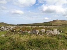
Tunhill Rocks Settlement
OS Map: SX 73200 75800
HER record: MDV7438
Megalithic Portal: 31984
ShortName: ST:TunhillRock
Nearby sites: SX73207580
Foales Arrishes Settlement
OS Map: SX 73700 75800
HER record: MDV7415
Megalithic Portal: 4623
ShortName: ST:FoalesArris
Notes: HER: A hut settlement with 8 hut circles, set within parallel reaves on Blackslade Down, including the enclosure known as Foale’s Arrishes. The hut circles were contemporary with the reaves, being either attached to them or linked by shorter walls. The site is also notable for the later imposition of a rectangular stone enclosure, which incorporated some of the reave elements and hut circles. Excavated by the DEC in 1897. Breton p.78
Nearby sites: SX73707580
Chittleford Hill Reported Cairn
OS Map: SX 72500 75400
HER record: MDV7469
ShortName: CN:Chittlefo1
Notes: Possible site of a Neolithic barrow found in the field walls by the roadside near the top of Chittleford Hill. A very large orthostat, or shiner (sic), standing here which may have been a capstone. Nearby fields called "Shelstone Lay" point to the existence of a cromlech. Also the walls of the field contain a large number of very large slabs and pillar-like stones such as might have formed a megalthic tomb.
Nearby sites: SX72507540
Blackslade Down Cist
OS Map: SX 73416 75519
HER record: MDV7437
Megalithic Portal: 32071
PMD: Blackslade Down
ShortName: CT Blackslade
Butler map: 9.8
Butler Vol 5: p.47 & Fig.26
DPD page: 129
Grinsell: WID 14
Barrow Report: 53 56
Notes: Butler Vol. 1. Map 9.8 (photo on p.61, diagram Vol. 5. p.47). Lethbridge diagram p.129 and photo bottom p.129.
Grinsell [Folklore 1976], Widecombe cist: Opened by a former parson of Widecombe, whose house was destroyed by an explosion the following night. Crossing 1911, 20.
Nearby sites: SX73427552
Wittaburrow Cairn
OS Map: SX 73353 75214
HER record: MDV7537
Megalithic Portal: 32069
Alternate name: Wittaburrow 1 Cairn
ShortName: CN:Wittaburr 1
Butler map: 9.9.1
Grinsell: WID 15
Notes: "A large stony round cairn, south of Wittaburrow. The mound has a 25 metre diameter at base, but the structure has been much altered, probably robbed, and is now quite low in places. A ‘bite-shaped’ section is missing from the main mound on the south-eastern side where a smaller cairn, which is unlikely to be an original feature, stands within the original spread of the monument. Two large hollows have been dug into the main mound which, overall, survives in a very uneven state."
Nearby sites: SX73357521
Wittaburrow 2 Reported Cairn
OS Map: SX 73358 75201
HER: No record found
ShortName: CN?Wittaburr 2
Butler map: 9.9.2
Notes: Butler: "A low mound of stones 5.0 m across and 0.3 m high, with a square pit at the centre lies 30 m to the south-east [of Wittaburrow]". Not listed on NMR or HER.
Nearby sites: SX73367520
Pudsham Down Reported Cairn
OS Map: SX 73270 74850
HER record: MDV31062
ShortName: CN?PudshamDown
Nearby sites: SX73277485
Seven Lords' Lands Encircled Cairn
OS Map: SX 74127 76237
HER record: MDV7396
Megalithic Portal: 3454
PMD: Seven Lord's Lands
Alternate name: Sevon Lords Lands Encircled Cairn
ShortName: EC 7LordsLands
Butler map: 9.10
Butler Vol 5: p.51 & Fig.29
Grinsell: WID 13
Turner: F1
Barrow Report: 53
Notes: A cairn from 0.8m. to 1.2m. high, with a minor central excavation 0.5m. deep. The kerb retaining circle extends round the west and north quadrants.
Nearby sites: SX74137624
Hemsworthy Gate (E of ) Reported Cairn
OS Map: SX 74570 76120
HER record: MDV26840
ShortName: CN?Hemsworthy
Grinsell: B:ILS 4a
Notes: Shaft of C19 tin mine, on some maps as cairn. T. Greeves
Nearby sites: SX74577612
Cold Cross East Reported Cairn
OS Map: SX 73999 74292
HER record: MDV30642
ShortName: CN Cold Cross
Butler map: 10.
Butler Vol 5: p.54 & Fig.32
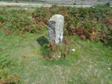
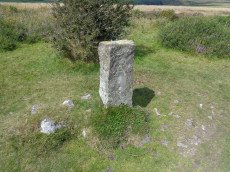
Notes: HER: One of several Prehistoric cairns running south from Blackslade Ford surmounted by a stone marking the boundary between Buckland in the Moor and Ashburton parishes. A low earthwork, the outline of which is a near perfect circle with a base diameter of 21 metres, though the interior comprises only irregular hummocks and pits. A parish boundary stone stands upright just west of centre.
Nearby sites: SX74007429
Blackslade Ford 1 Reported Cairn
OS Map: SX 73701 75120
HER record: MDV20169
ShortName: CN:Blackslad 1
Butler map: 10.
Grinsell: WID 24
Notes: HER: One of several Prehistoric cairns running south from Blackslade Ford surmounted by a stone marking the boundary between Buckland in the Moor and Ashburton parishes
Nearby sites: SX73707512
Blackslade Ford 2 Reported Cairn
OS Map: SX 73630 75197
HER record: MDV7534
ShortName: CN:Blackslad 2
Butler map: 10.7
Butler Vol 5: p.54 & Fig.31
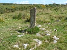
Notes: HER: Probable boundary marker just to the north of Blackslade Ford. One of a group of cairns continuing to the south of Blackslade Ford. Marks the boundary of three parishes Buckland in the Moor, Widecombe in the Moor and Ashburton.
Nearby sites: SX73637520
Blackslade Ford 3 Cairn
OS Map: SX 73790 74980
HER record: MDV30638
ShortName: CN:Blackslad 3
Butler map: 10.
Notes: HER: One of several Prehistoric cairns running south from Blackslade Ford. Badly obscured by gorse; not surveyed in 2015 as not accessible.
Nearby sites: SX73797498
Blackslade Ford 4 Cairn
OS Map: SX 73827 74872
HER record: MDV30634
ShortName: CN Blackslad 4
Butler map: 10.
Notes: HER: Described by Belsey and Butler as one of a group of cairns running south from Blackslade Ford surmounted by a stone marking the boundary between Buckland in the Moor and Ashburton parishes. Recently surveyed and not considered to be a cairn; part of the reave.
Nearby sites: SX73837487
Blackslade Ford (culvert) Reported Cist
OS Map: SX 73720 75060
HER record: MDV22823
PMD: Blackslade Ford
ShortName: CNxBlackslad 5
Notes: Site of cist reported to Greeves by D. Brewer in 1984 (SX7372 7506). Visited 13/2/1984. Thought to be a culvert. Features lies immediately on the north-east side of the track to Tunhill from near Cold East Cross. It lies a little east of south from a bound stone marked EPB 1837 and about 70 paces from the bound stone.
Nearby sites: SX73727506
Buckland Common 1 Reported Cairn
OS Map: SX 73772 73930
HER: No record found
ShortName: CN-Buckland 1
Butler map: 10.
Notes: Linear arrangement of mounds incorporated into boundary. Could be prehistoric cairns.
Nearby sites: SX73777393
Buckland Common 2 Reported Cairn
OS Map: SX 73742 73865
HER record: MDV30646
ShortName: CN Buckland 2
Butler map: 10.
Notes: HER: "A flattened and spread round cairn straddles the parish boundary between Buckland and Ashburton. A boundary stone is set into the cairn."
Nearby sites: SX73747387
Buckland Common 3 Reported Cairn
OS Map: SX 73588 73559
HER: No record found
ShortName: CN?Buckland 3
Butler map: 10.8
Notes: Linear arrangement of mounds incorporated into boundary. Could be prehistoric cairns.
Nearby sites: SX73597356
Buckland Common 4 Reported Cairn
OS Map: SX 73587 73556
HER: No record found
ShortName: CN?Buckland 4
Butler map: 10.8
Notes: Linear arrangement of mounds incorporated into boundary. Could be prehistoric cairns.
Nearby sites: SX73597356
Buckland Ridge (N) Cairn
OS Map: SX 73579 73510
HER record: MDV30631
ShortName: CN:Buckland 5
Turner: A47
Nearby sites: SX73587351
Buckland Down Reported Cist
OS Map: SX 73500 74000
HER: No record found
PMD: Buckland Down
ShortName: CT?Buckland 6
Notes: Butler Vol 1 p.115. One burial mound awaiting rediscovery is the cairncircle surrounding a cist on 'Buckland Down' mentioned in Note 43 to Carrington's poem on Dartmoor.
Nearby sites: SX73507400
Page last updated 10/12/24