
Guide to the Monuments on Hangingstone Hill

Table of Ritual and Burial Monuments on Hangingstone Hill
The following table lists the records currently in this Guide Map. For an explantion of the Guide Maps and a table of all 62 Guide Maps, follow this link: Guide List Table. Introductory text will be added to each guide list in 2025. Notes on duplication and omissions will appear below the table once checks have been finalised.
Notes on possible duplications and omissions
Wild Tor N.E.1 and N.E.2:.This is probably the cist and cairn excavated by Baring-Gould c1900. No trace of a cist today. Spooner observed a cairn in this vicinity in 1960. This maybe the cist excavated in 1900 or could be a different feature. Grinsell recorded these with two separate records, the second one marked here as a duplicate. Duplicate retained here for completeness of Grinsell records. No need for the HER to add a separate record, both are covered by MDV4370PS. These notes are to assist untangling complicated records and are neither permanent nor a criticism of the HER who do a fantastic job! The author finds it easier to systematically work through these records (2000+ of them) and add these notes, which are then to be communicated with the HER, if appropriate, it is a pragmatic way of dealing with lots of data without continually stopping and starting.
Hangingstone Hill Guide Map
Guidance for walkers: The monuments featured in this database are archaeological treasures and need to be protected and preserved - please do not disturb any sites. Please check access and firing times before visiting sites, not all sites listed are on open access land. Firing ranges and boundaries of open access areas are marked on the OL28 OS Dartmoor Explorer map. Please stick to the country code and consider giving support to the numerous agencies that help to keep Dartmoor a fabulous natural and historic environment!
List of Ritual and Burial Monuments on Hangingstone Hill
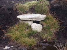
Whitehorse Hill Cist
OS Map: SX 61735 85482
HER record: MDV66367
Megalithic Portal: 29778
PMD: White Horse Hill
ShortName: CT Whitehorse1
DPD page: 131
Notes: This cist was excavated in August 2011. It possibly featured on an 1892 map by John Chudleigh in An Exploration of Dartmoor's Antiquities. It was re-discovered in 1999 and recently excavated.
Nearby sites: SX61748548
Whitehorse Hill 2 Reported Cairn
OS Map: SX 61722 85017
HER record: MDV7758
ShortName: CN:Whitehorse2
Notes: "The remains of a possible hut circle or cairn is visible as a crude circle of upright stones. The stones are partially turf-covered and measure up to 0.4 metres high."
Nearby sites: SX61728502
Whitehorse Hill 3 Reported Cairn
OS Map: SX 62360 85141
HER record: MDV130869
ShortName: CN:Whitehorse3
Notes: HER: Site of possible cairn and curved boundary feature recorded on Whitehorse Hill in 2021. Condition very ruinous condition with vegetation covering the majority of the features.
Nearby sites: SX62368514
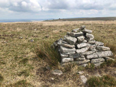
Hangingstone Hill Cairn
OS Map: SX 61704 86136
HER record: MDV4377
Megalithic Portal: 45858
Alternate name: Hangingstone Hill 1 Cairn
ShortName: CN:Hangingst 1
Butler map: 41.5
Grinsell: LYD 6
Notes: "A low, flat-topped cairn located on the summit of Hangingstone Hill. It measures 17.5m north to south by 15.0m at base and is maximum 1.4m high. It is apparently composed of medium sized granite slabs and boulders with a thin and patchy covering of turf. An ovoid hollow, 3.1m north to south by 2.0m and 0.3m deep, containing the stump of the flag pole (noted in the Devon SMR) lies slightly east of centre. A Range Wardens' hut encroaches on the southern side of the cairn. A considerable amount of peat has built up or has been deposited on the eastern side elongating the mound by some 10m in this direction." Partially excavated and repaired in 2016, see HER record. Butler Map 41.5 (Vol 2).
Nearby sites: SX61708614
Hangingstone Hill 2 Reported Cairn
OS Map: SX 61658 86059
HER record: MDV115805
ShortName: CN:Hangingst 2
Notes: HER : Possible cairn on Hangingstone Hill was found during excavation in 2017 to be a natural feature although a granite orthostat may have been erected using the natural cairn as a focal point in Prehistoric times.
Nearby sites: SX61668606
Hangingstone Hill 3 Reported Cairn
OS Map: SX 61929 86139
HER record: MDV115806
ShortName: CN:Hangingst 3
Notes: HER: Natural cairn on Hangingstone Hill used as a modern temporary military defensive position
Nearby sites: SX61938614
Hangingstone Hill N. Reported Cairn
OS Map: SX 61720 86430
HER record: MDV132818
ShortName: CNxHangingst 4
Butler map: 41.5
Notes: A cairn was alleged at this location but there is no ground evidence
Nearby sites: SX61728643
Watern Tor S. Cairn
OS Map: SX 62912 86086
HER record: MDV4376
ShortName: CN:WaternTor 1
Butler map: 41.3
Grinsell: LYD 8
Notes: "Cairn lies east of Hangingstone Hill. Measures 23 metres in length, 19.5 metres wide and 2.0 metres high."
Nearby sites: SX62918609
Watern Tor Reported Cairn
OS Map: SX 62910 86820
HER record: MDV4390
ShortName: CN:WaternTor 2
Butler map: 41.4
Grinsell: LYD 7
Notes: "Cairn on watern tor (diam 5.5m, height 500mm) granite slab (length 1.5m, width 1.0m, thick 250mm)". "1976 (grinsell) shown on os as cairn, but seems to be a natural outcrop." Scheduled Monument 1017482: Round cairn on Watern Tor.
Nearby sites: SX62918682
Wild Tor N.E.1 Cairn
OS Map: SX 62912 88080
HER record: MDV4370
ShortName: CN:Wild Tor 1
Butler map: 41.6
Grinsell: THR 1
Notes: This is probably the cist and cairn excavated by Baring-Gould c1900. No trace of a cist today. Spooner observed a cairn in this vicinity in 1960. This maybe the cist excavated in 1900 or could be a different feature. Grinsell recorded these with two separate records.
Nearby sites: SX62918808
Wild Tor N.E.2 Reported Cist
OS Map: SX 62912 88080
HER record: MDV4370
PMD: Gallaven Mire
ShortName: CT:Wild Tor 2
Grinsell: THR 2
Notes: Cist and cairn excavated by Baring-Gould c1900. Spooner observed a cairn in this vicinity in 1960. This maybe the cist excavated in 1900 or could be a different feature. Grinsell recorded these with two separate records. NB. This record is probably a duplicate. See also Wild Tor N.E.1 (THR 1. SiteID=1317).
Nearby sites: SX62918808
Wild Tor Reported Cairn
OS Map: SX 62218 87124
HER record: MDV107564
ShortName: CN-Wild Tor 3
Notes: Photo by Steve Granger and reproduced here with his kind permission (copyright remains with Steve). This site is clearly not a prehistoric cairn but is of interest as a reported cairn. Eric Hemery in High Dartmoor (pp.824-5) states "approximately opposite the centre of the south 'bulb' of Bow Combe hour-glass, is a ruined cairn om a square base where a path branches right from the crest and descends the east flank of the ridge towards Gallavan Down. Not far from the cairn are the remains of two shelters, one circular, the other oval. The first may have been a shepherd's shelter, and the latter, the larger of the two a peat-cutter's house."
Nearby sites: SX62228712
Wild Tor Clearance Cairn
OS Map: SX 62300 87700
HER: No record found
ShortName: CN?Wild Tor 4
Grinsell: B:LYD 111
Notes: Peat stacks, formerly mistaken for barrows. Prowse 1890, 189.Crossing 1912/1965, 238; Woolner 1967. See also Wild Tor Reported Cairn
Nearby sites: SX62308770
Page last updated 10/12/24