
Guide to the Monuments on Ringmoor Down
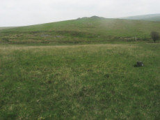
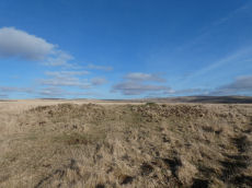
Legis Lake Encircled Cairn
OS Map: SX 56563 65513
NMR record: SX 56 NE 63
HER record: MDV3360
Megalithic Portal: 34135
Alternate name: Ringmoor Down 1 Encircled Cairn
ShortName: EC Legis Lake
Butler map: 49.21.1
Grinsell: SHE 21
Turner: F15
Barrow Report: 29 35
Notes: "cairn with retaining circle of which 5 stones protrude and there are indications of others. Diameter 8.2m, height 0.2m. Excavated by r. H. Worth: just n of centre, a pit containing charcoal mixed with earth."
Nearby sites: SX56566551
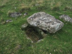
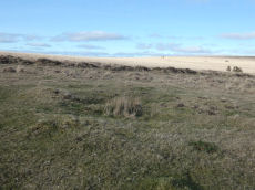
Legis Lake Platform Cairn Circle and Cist
OS Map: SX 56595 65762
NMR record: SX 56 NE 62
HER record: MDV4030
Megalithic Portal: 34131
PMD: Legis Lake
Alternate name: Ringmoor Down 2 Platform Cairn Circle and Cist
ShortName: CT Legis Lake
Butler map: 49.21.2
DPD page: 36
Grinsell: SHE 20
Turner: E32
Barrow Report: 29
Notes: Lethbridge Brisworthy Cist p.34-36. Diagram p.34 site 5. Butler Ringmoor Down 2 - Vol. 3. Map 49.21 (diagram p.145).
Nearby sites: SX56606576
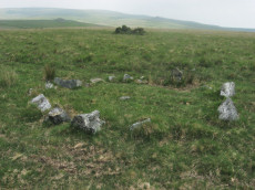
Ringmoor Down Cairn Circle
OS Map: SX 56157 65947
NMR record: SX 56 NE 61
HER record: MDV4029
Megalithic Portal: 22947
Alternate name: Ringmoor Down 3 Cairn Circle
ShortName: CC Ringmoor 3
Butler map: 49.21.3
DPD page: 36
Grinsell: SHE 18
Turner: G29
Barrow Report: 63
Notes: Located about 230m NW of the cairn circle that terminates the Ringmoor Down stone row. "An 11ft 2ins diameter cairn circle composed of fourteen stones of which four have fallen over. Stones of quartz-schorl, not granite." "This feature has the semblance of having been recently created. The stones are mostly loose and irregularly spaced. As a monument type it appears to be unique on Dartmoor. It should not be considered of great antiquity." For a photo, see: Stone-Circles.org.uk: Ringmoor Cairn. Lethbridge kerb circle p.34-36. Diagram 34 site 4.
Nearby sites: SX56166595
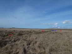
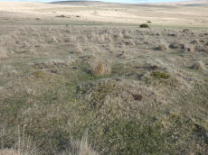
Ringmoor Down Stone Ring Cairn Circle
OS Map: SX 56113 65922
NMR record: SX 56 NE 161
HER record: MDV19760
Megalithic Portal: 34142
Alternate name: Ringmoor Down 4 Stone Ring Cairn Circle
ShortName: CC Ringmoor N
Butler map: 49.21.4
Turner: A2
Notes: Feature described as "Low embanked circle with no ditch, 36.0 metres diameter overall. A few upright stones still remain in the bank".
Butler, 1994: "barely visible circular enclosure .. its position on the ridge suggesting a large ring cairn rather than a domestic enclosure. The flat interior 35 m across, disturbed by a line of tinners' pits, is surrounded by a low bank no more than 0.1 m high supporting a few earthfast slabs"
Turner, 1990: "Stone ring 31.5 metres in diameter internally, with bank 0.7 metres wide and 0.15 metres high. A few upright stones still remain in the bank".
Newman, P. + Probert, S., 2005: This feature is now largely obscured by dense Molinia. Only a 35m section of slightly curving bank is visible between SX 5612 6591 and SX 5613 6588. None of the stones noted by the Ordnance Survey (1979) are in situ, there being just two clusters of three stones each. It seems unlikely that this could represent an embanked stone circle it seems more likely to be an ephemeral part of the surrounding medieval field system.
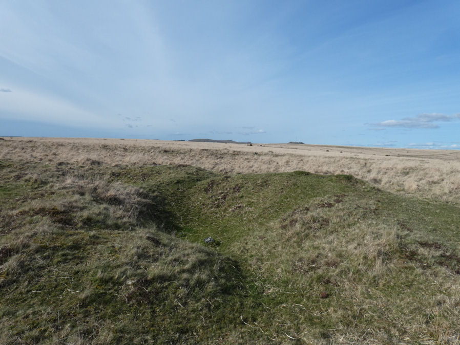
The current author has failed to find this feature on multiple occasions. Most recently on 9th April 2023. A follow up visit on 15th April 2023 has led to the conclusion that this site is perhaps better considered to be an enclosure or part of the surrounding medieval field system as suggested by Newman + Probert.
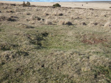
In the photo it is very difficult to make out the stones due to the long Molinia grass so I have ringed them in red. There are in fact two groups of three stones but I have ringed what I can see in the photo. The one furthest to the right is actually my rucksack sat on top of one stone that would not be visible otherwise. The stones circled in blue a little way in the distance are from the nearby Ringmoor Down Cairn Circle (also dubious as most stones not earthfast).
Butler himself debates whether the low bank represents an enclosure or a ring cairn. Lidar data available to a more modern perspective suggests not a circular feature but a rectangular enclosure. The following extract from Lidar shows that along with 3 of the tinners pits below.
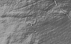
To conclude in our view this is not a ring cairn. This record is being retained as this is a reported ring cairn that is part of both the Butler and Turner listings. However, the CairnClass classification has been changed from yes to No.
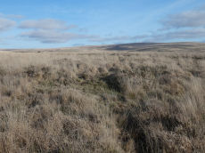
The photo below taken on 15-04-2023 shows one of the tinners pits at SX 56118 65903.
Nearby sites: SX56116592
Ringmoor Down 5 Cairn
OS Map: SX 56032 66052
NMR record: SX 56 NE 164
HER record: MDV20142
ShortName: CN Ringmoor 5
Butler map: 49.21.5
Grinsell: SHE 10
Notes: "The robbed remains of a cairn lie on the crest of Ringmoor Down 20m south-east of the course of the Eylesbarrow Reave. the remains consist of a flat-topped mound 13m in diameter and a maximum of 0.4m high on the north-west side. It appears to have been heavily robbed - probably during the reconstruction of the reave in the medieval period. A slight rim, 0.15m high, runs around the crest of this feature. There is no suggestion of a cist or kerb associated with this cairn. An old slit trench lies in the western quadrant and this feature is now covered in dense molinea grass." Visited by author 19/02/2023.
Nearby sites: SX56036605
Ringmoor Down 6 Cairn
OS Map: SX 56030 66266
NMR record: SX 56 NE 59
HER record: MDV3992
ShortName: CN Ringmoor 6
Butler map: 49.21.6
Grinsell: SHE 12
Notes: "Northern of two turf covered cairns of 19.5 metres diameter by 1.2 metres high. Slightly mutilated on its western side by military operations, otherwise in good condition". Visited by author 19/02/2023. Quite a substantial cairn. Shows the same L-shaped trenching on the western side as found on the 3 (North of Row) reported cairns 4121-4123. HER suggests the trenching is from military activities.
Nearby sites: SX56036627
Ringmoor Down 7 Cairn
OS Map: SX 56025 66191
NMR record: SX 56 NE 59
HER record: MDV3993
ShortName: CN Ringmoor 7
Butler map: 49.21.7
Grinsell: SHE 11
Notes: "Southern of two cairns south-east of Ringmoor Cottage of 21.5 metres diameter by 1.0 metres high". Visited by author 19/02/2023.
Nearby sites: SX56036619
Ringmoor Down 8 Cairn Circle
OS Map: SX 56590 66692
NMR record: SX 56 NE 58
HER record: MDV3994
PMD: Ringmoor Down
ShortName: CN:Ringmoor 8
Butler map: 49.21.8
Grinsell: SHE 13
Notes: Radcliffe notes; "There are remains of a retaining circle consisting of five stones, all standing, visible in SW quadrant. Dia 13m, ht 0.5m. Secondary cist and retaining kerb exposed."
Nearby sites: SX56596669
Ringmoor Down 9 (3 cairns) Reported Cairn
OS Map: SX 56600 66720
NMR: No record found
HER record: MDV20143
ShortName: CN?Ringmoor 9
Butler map: 49.21.9
Grinsell: SHE 13a-c
Notes: Could these be Ringmoor Down (N. of row) 1-3 (HER 22767). Butler clearly has these near Ringmoor cairn 8 - which suggests it is a different group of 3 cairns of similiar size.
Nearby sites: SX56606672
Ringmoor Down 10 Cairn
OS Map: SX 56881 66744
NMR record: SX 56 NE 191
HER record: MDV12716
ShortName: CN:Ringmoor 10
Butler map: 49.21.10
Grinsell: SHE 13d
Nearby sites: SX56886674
Ringmoor Down 11 Cairn
OS Map: SX 57024 66826
NMR record: SX 56 NE 163
HER record: MDV29077
ShortName: CN:Ringmoor 11
Butler map: 49.21.11
Nearby sites: SX57026683
Ringmoor Down 12 Cairn
OS Map: SX 57141 66638
NMR record: SX 56 NE 192
HER record: MDV12717
ShortName: CN:Ringmoor 12
Butler map: 49.21.12
Grinsell: SHE 14
Nearby sites: SX57146664
Ringmoor Down 13 Reported Cairn
OS Map: SX 56910 66760
NMR record: SX 56 NE 162
HER record: MDV56210
ShortName: CN?Ringmoor 13
Nearby sites: SX56916676
Ringmoor Down (N. of row) 1 Reported Cairn
OS Map: SX 56269 66263
NMR: No record found
HER record: MDV42768
ShortName: CN Ringmoor 3
Notes: "Formerly identified and scheduled in the 1990s as a cairn (one of a group of three), this was re-assessed during 2005 survey work. Identified as former tin pits that have been reoccupied by the military in the more recent past."
Author visited 19/02/2023. I'm inclined to agree with the HER assessment. Now listed as a "reported cairn".
Nearby sites: SX56276626
Ringmoor Down (N. of row) 2 Reported Cairn
OS Map: SX 56291 66280
NMR: No record found
HER record: MDV42769
ShortName: CN RingmoorN2
Notes: "A low flat-topped mound measuring 7.3m north-south by 7.0m and standing a maximum of 0.4m high. An amorphous hollow lies slightly west of centre. While this feature appears in form to be a prehistoric cairn it overlies ridge and furrow and is associated with a number of tin pits that have been adapted for military training. At the earliest it is probably a post medieval stone clearance heap". Author visited site 19/02/23. A very disturbed feature consistent with the description on the HER quoted above. SX 56293 66282 on my garmin.
Nearby sites: SX56296628
Ringmoor Down (N. of row) 3 Reported Cairn
OS Map: SX 56303 66265
NMR: No record found
HER record: MDV42770
ShortName: CN RingmoorN3
Notes: "Formerly identified and scheduled in the 1990s as a cairn (one of a group of three), this was re-assessed during 2005 survey work. Identified as former tin pits that have been reoccupied by the military in the more recent past."
Visited by the author 19/02/23. L-shaped trench in the feature at SX 56307 66267. There is another L-shaped trench about 9 metres to the west at SX 56298 66263. The trenching could be activities by the military as described by Newman, P. + Probert, S in the HER entry. This does look a dubious cairn and the suggestion of tinners pit later re-used by the military seems plausible. This feature is now listed here as a "reported cairn" as not thought to be prehistoric.
Nearby sites: SX56306627
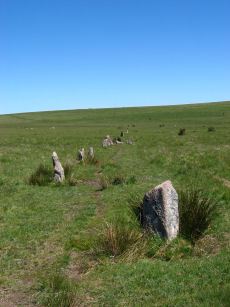
Ringmoor Down Encircled Cairn
OS Map: SX 56334 65807
NMR record: SX 56 NE 60
HER record: MDV3987
Megalithic Portal: 1233
PMD: Ringmoor Down Stone Row
Alternate name: Ringmoor Down stone row Encircled Cairn
ShortName: EC Ringmoor S
Butler map: 49.20
DPD page: 35
Grinsell: SHE 19
Turner: F5
Notes: "The cairn circle measures approximately 12.6m. in diameter and has eleven stones averaging 0.7m. high. The disturbed central cairn is 9.5m. in diameter and 0.4m. in height." "1909 the circle was restored and five of the present stones were introduced from elsewhere. Prior to restoration one stone was standing, four had fallen and the presumed sites of six other stones were represented by pits." Lethbridge Brisworthy cairn circle p.34-35. Diagram p. 34 site 2.
Nearby sites: SX56336581
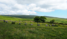
Ringmoor Down Stone Row
OS Map: SX 56330 65808
NMR record: SX 56 NE 60
HER record: MDV3986
Megalithic Portal: 2102
The Stone Rows of GB: Ringmoor Down
PMD: Ringmoor Down Stone Row
ShortName: SR Ringmoor
Butler map: 49.20
DPD page: 34
Notes: "A stone row, 1740 feet long, mainly single but double in parts. At its southern end is a cairn circle with a diameter of 40ft. 6ins. In 1909 the circle was restored and five of the present stones were introduced from elsewhere. Prior to restoration one stone was standing, four had fallen and the presumed sites of six other stones were represented by pits. A 4ft long fallen stone terminated the stone row at its northern end". Lethbridge p.34-36, diagram p.34 site 3. See also: Sea Views at Ringmoor Down`
Nearby sites: SX56336581
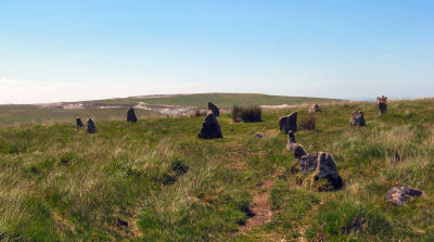
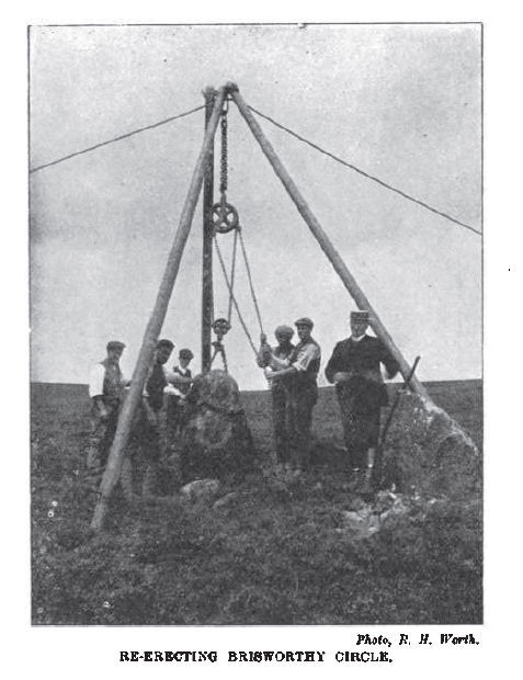
Brisworthy Stone Circle
OS Map: SX 56467 65495
NMR record: SX 56 NE 64
HER record: MDV3983
Megalithic Portal: 542
PMD: Brisworthy Stone Circle
ShortName: SC Brisworthy
Butler map: 49.8
DPD page: 35
Turner: G8
Barrow Report: 29 35
Notes: The Brisworthy circle underwent major reconstruction carried out by Breton and the Barrow Committee in 1909. At the time only 4 stones remained standing whilst another 21 were lying roughly in place. Some 15 stones out of 40 are missing, no doubt robbed for nearby enclosures and walls. A low rubble bank surrounds the circle which can be seen on LIDAR data. This is discussed in detail in the article 'Dartmoor Site: Brisworthy Stone Circle' linked above in this listing.
See also: Legendary Dartmoor: Dartmoor's Brisworthy Circle. Lethbridge p.34-35. Diagram p.34 site 1.
Nearby sites: SX56476550
Page last updated 01/05/23