
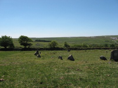
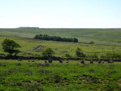
Brisworthy Stone Circle
This site is featured on the Burrator 3: Ringmoor, Brisworthy Circle and Legis Pound walk. The photos below are of the Brisworthy Stone Circle (SX56476549 Butler Vol. 3. Map 49, 8). The Brisworthy circle underwent major reconstruction carried out by Breton and the Barrow Committee in 1909. At the time only 4 stones remained standing whilst another 21 were lying roughly in place. Some 15 stones out of 40 are missing, no doubt robbed for nearby enclosures and walls. The site was planned long before the restoration by Lukis in 1879 and again by Worth just before the restoration. Worth states that "the only result of the excavation, which was not very thorough, was the discovery of a very trifling amount of charcoal and one rough flint flake" (see Barrow Report 35 below).
The Brisworthy Circle, like many other Dartmoor circles, is associated with a range of other nearby monuments. Within 100 metres there is the Legis Lake Encircled Cairn. Around 300 metres to the north there is the Ringmoor Stone Row & Cairn Circle and to the west is the Legis Lake Cairn Circle and Cist. In the wall to the south-west of the circle near the entrance to Brisworthy is a rare example of a cup-marked boulder set into the wall, the Brisworthy Cup Stone. Possibly contemporary with the circle, it has 15-18 hollows forming no discernible pattern.
Brisworthy Circle: Stone Circle, Ring Cairn or Henge?
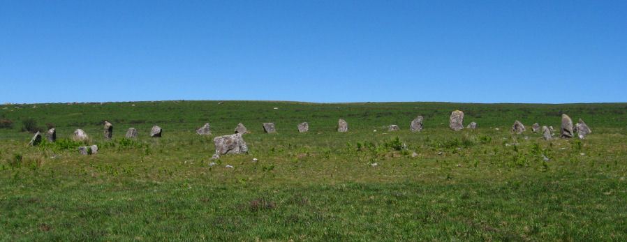
Bank surrounding Brisworthy Circle in NE quadrant.
In our main article on stone circles we note that Gerrard (1997) speculates as to whether the Brisworthy Circle could in fact be a ring cairn. Pointing out that some sites can be difficult to classify, Gerrard writes:
"The large stone circle at Brisworthy is also problematic in this respect. A low rubble bank, some 2.5m (8ft 8in) wide surrounds 75 per cent of the circumference and may indicate that this particular monument is a ring cairn." Sandy Gerrard 'Dartmoor' (1997)
As a general rule all cairn circles on Dartmoor are less than 20 metres in diameter and all stone circles are larger than this. For example the Dancers, or Erme Circle at the end of the Stall Moor (Upper Erme) Stone Row, is 15.8m in diameter, the outer of the circles at the Yellowmead 4-circle is 18.7m. The Brisworthy Circle has a diameter of around 25m which would make it huge in comparison with other cairn circles on Dartmoor. That of course doesn't stop it from being one but it would make it exceptional in terms of size. There is one circle of stones which is in turn surrounded by a bank and that is the Mardon Down Embanked Cairn Circle but that is a mere 11m in diameter.
Butler comments on the shape of the Brisworthy Circle.
"The circle is 25.0m across east to west but slightly flattened on the north side shrinking this diameter by about a metre. The stones along this quadrant were all re-erected in the position they were lying as shown on Worth's pre-restoration plan, but perhaps incorrectly. Whether the members of the Barrow Committee re-locted the socket holes first in not stated but the grossly uneven spacing may also not be an original feature. None of the surviving stones are exceptionally tall or show gradation in size, the four which remained standing being 0.8m to 1.0m in height like many of those replaced." Butler (1994)
Butler later also comments on the bank suggesting that it could just be the result of the restoration by the Barrow Committee in 1909.
"At Brisworthy traces of a bank outside the north-east quadrant are probably a later feature, perhaps no older than the Barrow Committee's restoration of 1909" Butler 'Dartmoor Atlas of Antiquities Vol 5' (1997).
The bank in the north-east quadrant is indeed easier to see as can be seen in this photograph taken in 2010. However there is no sign of a bank at the Langstone Moor or White Moor (Little Hound Tor) circles that were also restored by the same people. It is not clear why such a substantial bank would be created by the restorers. Hugh Breton was one of those involved in the restoration. He writes:
"The circle is one of the finest on Dartmoor, although the Grey Wethers and Scar Hill [Scrohill] are larger specimens. It's diameter is about 80 feet, and it consists of twenty-four stones; originally all except three lay prostrate on the ground until the summer of 1909, when Mr. R. Hansford Worth and I re-erected the stones of this beautiful monument." Breton 'Beautiful Dartmoor' (1911).
The twenty-ninth barrow report in 1910 states:
"At various times during the examination of Brisworthy Circle and the associated remains, there were present the Rev. H. H. Breton, Mr R. Burnard, Mr. Ford, Dr. Prowse, Mrs. Hansford Worth, and the Secretary, who exercised constant supervision." Worth (1910)
Worth did later complain about the restoration of the nearby Ringmoor circle at the end of the stone row.
"Five of the stones of the retaining circle were imported in an effort at the restoration" Worth (1953)
So perhaps the constant supervision was not quite as constant as claimed! Indeed, later in the thirty-fifth barrow report the members of the committee were "present at various times while the work was in progress". All the same it seems highly unlikely that the bank was created by the restorers and it is clear that Worth woud not have allowed it.
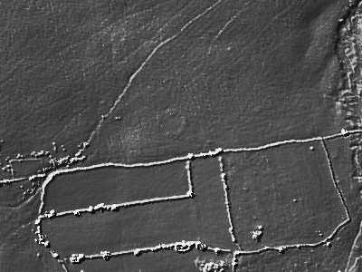
LIDAR imagery centred at SX56476550. Source
There is now available LIDAR imagery which shows that the bank is not just restricted to the north-east quadrant it is indeed all around the circle although this may not be immediately obvious to a visitor to the site. However, on close inspection the bank can be seen in some of the photos below. LIDAR imagery at the locations of the other circles, including those that have been restored, not only show no bank but in fact show nothing at all as the stones are just pin-pricks in LIDAR imagery. Closer inspection of this image gives a hint of two entrances. It is difficult to confirm the entrances and maybe higher resolution LIDAR data or other geophysics techniques will confirm or discount the existence of entrances. The other feature required for a henge is an internal ditch next to the bank. Again modern techniques could confirm whether or not there was once a ditch or whether there are still remnants of one.
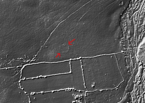
Possible entrances in the bank surrounding Brisworthy Circle
The possibility of entrances between the stones may have been noticed by previous authors.
"The larger gaps between stones, eg A, may be original but are more likely to be the result of later agricultural activity. The low mound at B and tiny 'field clearance' heap at C are presumably also part of that process. It is, however, possible that at least one gap, such as D, could be an original 'entrance'". Clare (1984)
The accompanying diagram (for which we do no have copyrght permission to reproduce) looks like it has has A in the SE east quadrant, B is on the western side, C is part of the clear bank in the north-east and D possibly coincides with the apparent southern "entrance" on the Lidar. Clare raises another important source of disturbance of the site and that is agriculture. The Eylesbarrow reave passes across Ringmoor Down to the north of the stone circle. This would suggest that the area was in use for agriculture in the Late Bronze Age. There are also clear signs of medieval ridge and furrow ploughing all across Ringmoor Down. This can probably be seen as the scratch marks on the LIDAR imagery. Of course any bank and ditch will tend to be levelled and filled in by such activity.
In a Facebook posting on 09/06/15 Sam Goodwin also observes two possible entrances.
The circle of 24 stones has been restored apparently faithfully, the stone holes deepened to ensure that they wouldn't fall again. Theres one important feature of this site that is almost always overlooked, a feature that sets it apart from all the other circles on Dartmoor. A low bank of fist - head sized stones that encircles two thirds of the perimeter. The largest stone in the ring is to the north, beside it another large stone, smaller stones on either side emphasise the size of these stones. It is an entrance. An architectural trait found also at Castlerigg where smaller stones were used to enhance the size of the entrance. At Brisworthy there are tall stones set in the east and west respectively. The southern part of the ring has been robbed of many stones, courtesy of the gate post merchant. A low stump of a stone once perhaps the tallest in the ring bears the evidence of the merchants tools, it has been holed and split. (In the nearby enclosure wall to the S.E. are two tall gate posts, one of which I believe to be what remains of this stone). Adjacent to the split stump is a stone hole, besides it another larger hole suggesting a large slab or slabs have been removed. On the southernmost edge of the stony bank are two more stone holes, which if they had held stones, would with the other two pillars, have formed a portal entrance. Mirroring the entrance to the north. The features- originally 40 close set stones, a stony surrounding bank, entrance (s), cardinal points, large diameter, all features identical to the great circles far to the north. Brisworthy circle is a northern ring in a southern setting!
So what is Brisworthy Circle? Well maybe it is a stone circle, maybe it is a ring cairn and maybe it is henge monument. What is clear is this is not a typical Dartmoor stone circle.
See also: Guide to Dartmoor Stone Circles
Bibliography & references
Breton, Henry Hugh, Beautiful Dartmoor And Its Interesting Antiquities, (1911 republished 1990)
Breton, Henry Hugh, The Forest of Dartmoor, (1931, rpublished 1990)
Burl, Aubrey The Stone Circles of the British Isles (Yale University Press, 1976)
Butler, J. Dartmoor Atlas of Antiquities: Vol. 3. - The South-West (Devon Books, 1994)
Butler, J. Dartmoor Atlas of Antiquities: Vol. 5. - The Second Millennium B.C. (Devon Books, 1997)
Clare, T, Archaeological Sites of Devon and Cornwall, (1982)
Gerrard, Sandy, English Heritage Book of Dartmoor: Landscapes Through Time, (1997)
Lukis, W.C, Report on the Monuments of Dartmoor, Proceeding of the Society of Antiquaries Vol. 8 (1881)
Pettit, Paul. Prehistoric Dartmoor (David & Charles, 1974)
Worth, R.H., Twenty-ninth Report of the Barrow Committee, T.D.A. Vol. 42 pp.62-63 (1910)
Worth, R.H., Thirty-fifth Report of the Barrow Committee, T.D.A. Vol. 48 pp.99-101 (1916)
Worth, R.H. Worth's Dartmoor (David & Charles, 1971, first published in 1953)
The Restoration of Brisworthy Circle
Thirty-fifth report of the Barrow Committee
Thirty-fifth Report of the Committee - consisting of the Rev. S. Baring-Gould, Mr. R. Burnard, the Rev. J. F. Chanter and Mr. R. Hansford Worth (Secretary) - appointed to collect and record facts relating to Barrows in Devonshire, and to take steps, where possible, for their investigation.
Edited by R. Hansford Worth, Secretary of the Committee. (Read at Plymouth, 10th July, 1916.)
Brisworthy Circle after being restored in 1909.
Restoration of Brisworthy Circle, the largest stone is put in place
Brisworthy Stone Circle.
In the Twenty-ninth Report (1910) reference is made to a stone circle on Ringmoor and to a cairn in its immediate neighbourhood.
The stone circles of Dartmoor, other than hut-circles, are very commonly associated with sepulchral remains. In some instances the circles actually enclose barrows, as on Stallmoor at the southern end of the long stone row in the Erme valley. Instances have been found where, although no barrow lay within the circle, yet on excavation its area yielded every evidence of large fires having been lit therein, in such cases barrows and cairns were associated with the circles. At Brisworthy Circle on Ringmoor the only result of the excavation, which was not very thorough, was the discovery of a very trifling amount of charcoal and one rough flint flake ; but there is a cairn at 313 feet N. 77° E. from the circle, and this cairn covered what was evidently an interment after cremation.
Brisworthy Circle was carefully restored in the year 1909, the Rev. H. H. Breton, of Sheepstor, being the initiator of the restoration, and the Rev. S. Baring-Gould, Mr. R. Burnard, and the Secretary of your Committee being present at various times while the work was in progress.
Your Committee's Secretary made a survey of the circle before the work of restoration had been commenced, and this survey is now published. If it be argued the matter is somewhat outside the province of our reports, the association of stone circle and barrow must be the reply, and the especial fitness of the record in the present year, when we hope on our long excursion to visit this antiquity. Nor should original surveys of restored monuments be left too long in private hands, the danger of their irreplaceable loss is too great.
On the plan herewith, the dotted circle has a diameter of eighty feet, and it will be seen that it just touches the three stones on the west and the one stone on the east that were still standing (standing stones are indicated by hatching). It would appear that the internal diameter of the circle as originally constructed was eighty feet. The standing stones were somewhat massive, and the highest (on the east) stood 3 ft. 8 ins. above ground.
Of fallen stones, undoubted members of the circle, there were eighteen, while the positions of two others were indicated by "triggers" and of one more by a pit.
There is a stone fence to the south of the circle, and the southern half has been robbed of nearly all its members, a fact which is something more than a coincidence; one stone on this southern side had been cut in two and a part only taken away.
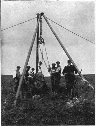
Judging by the most perfect portions of the circumference the stones were originally six feet apart from centre to centre, and accordingly there would have been about forty-two before the monument was robbed. Twenty -two are now left. These have been carefully re-erected; most were put up by hand, but one required the use of sheer-legs. By the courtesy of the Rev. H. H. Breton a block showing this pillar in course of re-erection is here inserted.
On the plan, such portions of the stones as were buried beneath the turf are indicated by dotted lines.
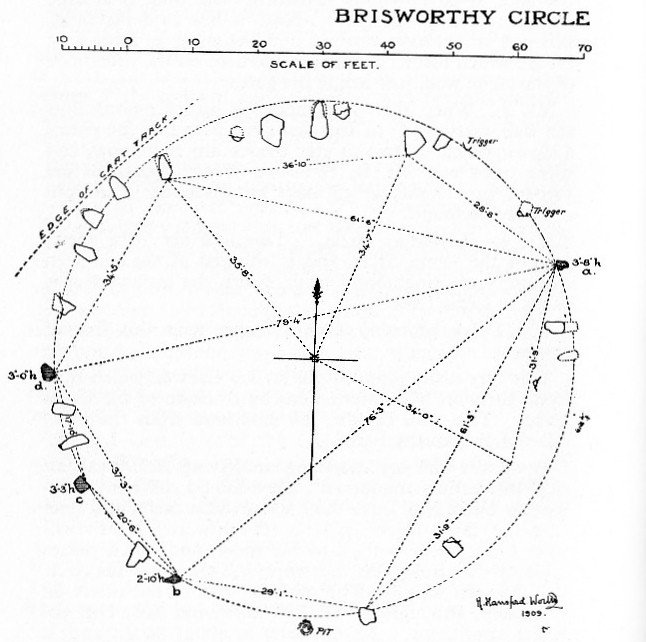
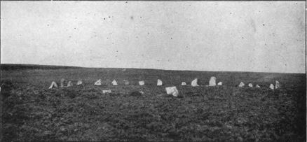
Brisworthy Circle planned by Worth before restoration
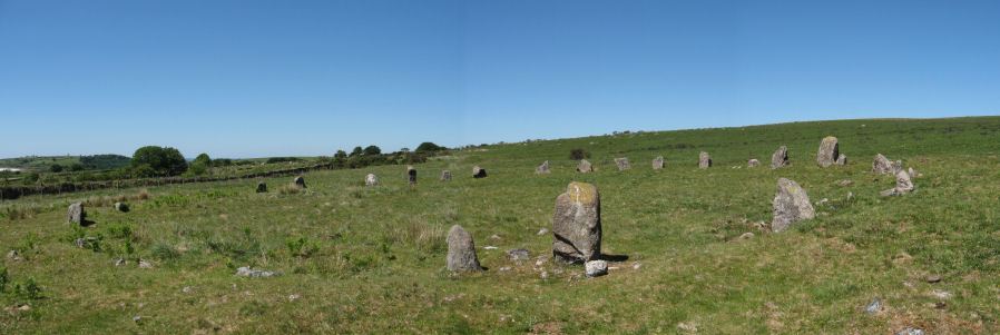
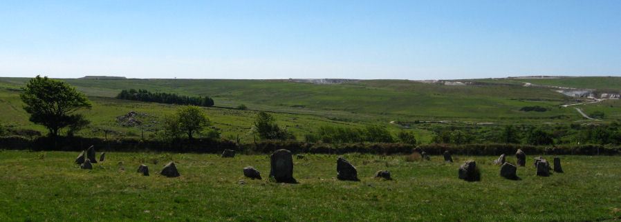
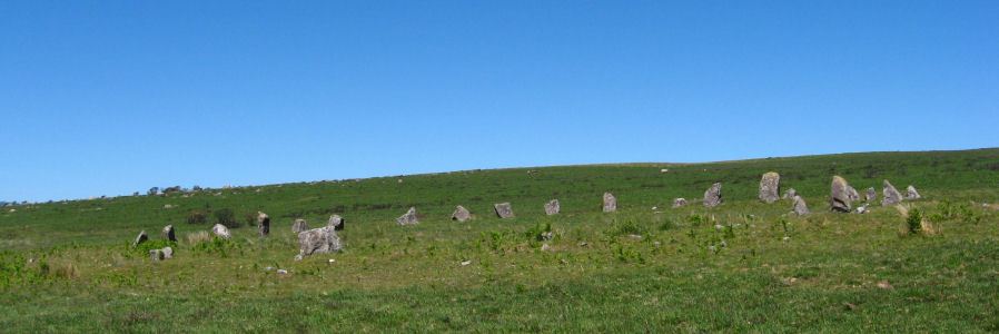
Brisworthy Circle
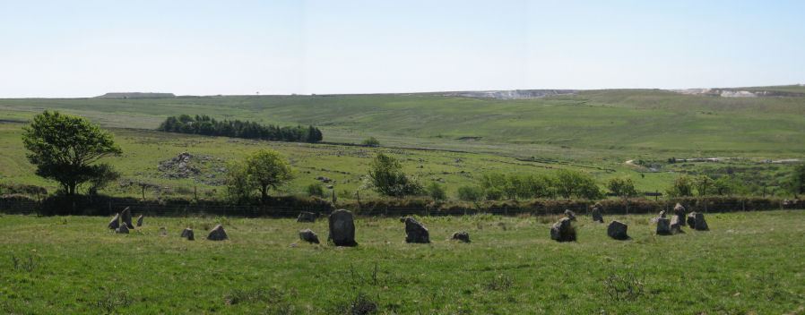
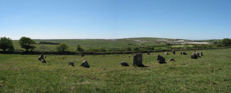
The photos below of Brisworthy Circle were taken on the 17th June 2010. The last two photos here are of a nearby reave. This is the Eylesbarrow reave which stretches over 4 km from Eylesbarrow on to Ringmoor Down. It can be seen on the OS Map marked as Boundary Work.
Page last updated 30/09/2017