
Prehistoric sites within 2km of SX 63900 60100
Guidance for walkers: The monuments featured in this database are archaeological treasures and need to be protected and preserved - please do not disturb any sites. Please check access and firing times before visiting sites, not all sites listed are on open access land. Firing ranges and boundaries of open access areas are marked on the OL28 OS Dartmoor Explorer map. Please stick to the country code and consider giving support to the numerous agencies that help to keep Dartmoor a fabulous natural and historic environment!
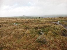
About the database listings: In all listings clicking on the photo or the site name will open a page for the site with a larger photo and further details from the database. The database now has over 6680 records covering nearly all publicly listed sites on Dartmoor including around 4800 round houses. This level of detail is of interest to archaeologists but tends to swamp listings of sites more likely to be of interest for walkers. For this reason, the listings default to around 550 core sites only. These are the stone circles, stone rows and the ring cairns listed by Turner. The default search radius is 2 km. The controls below the map can be used to start a new search by entering a 6- or 8-digit reference (without the prefix "SX"). The search radius can be specified and you can add incremental Display layers of detail on top of the core sites. If using a more detailed layer you will need to decrease the search radius to avoid getting hundreds of search results.
- Core sites Default listing of core sites consisting of stone circles & rows and some of the major ring cairns.
- Plus cairns adds approx. 1000 cairns and other minor sites not included in the core listings but excluding round houses.
- Plus round houses adds approx. 4800 round houses.
- Plus non-sites adds in the records for sites that no longer exist or are not prehistoric sites.
- Plus duplicates adds records excluded as duplicates. Those maybe duplicate records in external listings (e.g. the Historic Environment Records). For example, some sites have been identified as cairns in some listings and interpreted as round houses in other listings and both records appear.
These listings have incorporated, matched up and merged all of the records from all of the major archaeological listings including: Worth, Grinsell, Turner, Butler, Bill Radcliffe, Sandy Gerrard, Megalithic Portal, the National Monument Records and the Historic Environment Records. The author would like to thank Bill, Sandy, the lovely people both at Megalithic Portal (especially Anne Tate who did an amazing job to link listings) and at ACE Archaeology for collaborative work over the years to synchronise and correct listings across the various websites which now interlink. A culmination of years of work the final merger of cairn records took 3 months of cross referencing in 2017 the result being a snapshot of the records at that time. This data has in turn been refined since by field work and research. The round house data was supplied by Sandy Gerrard. Grid references are in order of accuracy: from Google Earth satellite, if visible and found, from a Garmin GPS reading, if visited by the author and from the literature otherwise. Individual site pages will state the source of the grid reference and provide satellite imagery. If a site listing lacks a photo it has not yet been visited by the author in which case the grid reference is from the literature.
Currently the database only includes sites which can be represented by a grid reference. Reaves are not included as they require GIS shape technology which is beyond the current capability of this system. To see the sources for the records, look at the tables on the resources menu. The database listings can also be viewed on a Google map and downloaded as GPS datasets for Garmin devices.
Corrections, or any feedback or suggestions are very welcome, email: info@dartmoorwalks.org.uk.
NOTE: Clicking on the icons for each monument in the map will give the name of the site. You can zoom in and out and drag the map around.
List of sites within 2km of SX 63900 60100
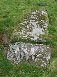
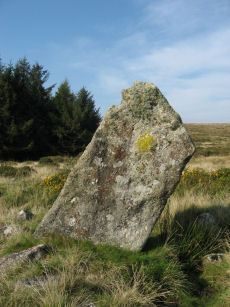
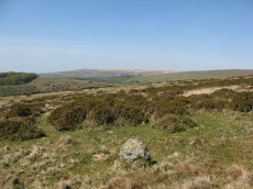
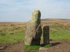
Burford Down Standing Stone
Prehistoric Dartmoor Walks: Dartmoor Site: Burford Down stone row and cairns
OS Map: SX 63703 60687
HER: MDV4333
Megalithic Portal: 1463
PMD: Burford Down Stone Row
ShortName: SS BurfordDown
Butler map: 54.17
DPD page: 70
Notes: "The alleged blocking stone noted by Parsons measures 2.7m by 1.0m and has been split by drilling." TDA Vol. 85 (1953) pp. 145-147 (Hamlyn Parsons).
Nearby sites: SX 63703 60687
Distance: 0.62km
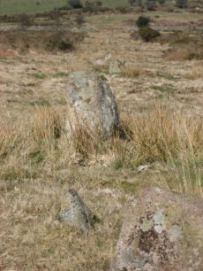
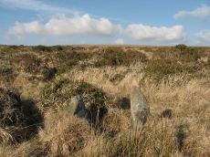
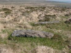
Burford Down Stone Row
Prehistoric Dartmoor Walks: Dartmoor Site: Burford Down stone row and cairns
OS Map: SX 63695 60165
HER: MDV4333
Megalithic Portal: 1463
The Stone Rows of GB: Burford Down
PMD: Burford Down Stone Row
ShortName: SR BurfordDown
Butler map: 54.17
DPD page: 70
Barrow Report: 14 40
Notes: "This single stone row on a slight north slope extends from a crest at 260m OD to a col at 255m OD. It can be traced from its south terminal, marked by a cairn, at SX 63706017 for 336m, bearing 1o, to a possible blocking stone at SX 63706051 and of different character for a further 120m to SX63706062. The recumbent stone, considered ... to be the north terminal lies yet a further 47m distant at SX 63706067." See also: Sea Views at Burford Down
Nearby sites: SX 63695 60165
Distance: 0.22km
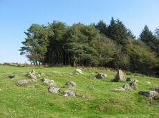
Burford Down Encircled Cairn
Prehistoric Dartmoor Walks: Dartmoor Site: Burford Down stone row and cairns
OS Map: SX 63704 60178
HER: MDV4257
Megalithic Portal: 719
PMD: Burford Down Stone Row
Alternate name: Burford Down stone row Encircled Cairn
ShortName: EC BurfordDown
Butler map: 54.17
DPD page: 70
Grinsell: HAR 5
Turner: F10
Barrow Report: 14 40
Notes: "The south terminal cairn, 9.0m diameter and 0.6m high, has a central depression, about 2.5m diameter and 0.4m deep, and is edged by 3 upright and 2 fallen orthostats, average 0.7m by 0.2m and up to 0.9m high, the remains of a retaining circle or peristalith."
Nearby sites: SX 63704 60178
Distance: 0.21km
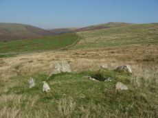
Burford Down (Tristis Rock) Platform Cairn Circle and Cist
Prehistoric Dartmoor Walks: Dartmoor Site: Burford Down stone row and cairns
OS Map: SX 6378 6016
HER: MDV4258
Megalithic Portal: 45689
PMD: Tristis Rock
Alternate name: Tristis Rock Platform Cairn Circle and Cist
ShortName: CT TristisRock
Butler map: 54.17
DPD page: 70
Grinsell: HAR 6
Turner: E22
Barrow Report: 14 40
Notes: "Retaining circle of a barrow, internal diameter between 16 and 17 feet and consisting of twelve stones which enclose the remaining south side stone of a cist. The overall length of the side stone is 4 feet 6 inches, the internal length of the cist would not have been more than 3 feet". Butler Tristis Rock - Vol. 4. Map 54.17 (p.60 diagram of Tristis Rock cairn p.59).
Nearby sites: SX 6378 6016
Distance: 0.13km
Butter Brook Standing Stone
Prehistoric Dartmoor Walks: Dartmoor Walk: The Neolithic tombs of Cuckoo Ball & Corringdon Ball
OS Map: SX 64747 59301
HER: MDV13095
Megalithic Portal: 45565
PMD: Butterbrook Standing Stone
ShortName: SS ButterBrook
Notes: The stone is easy to approach from the dry ground to the south but just beyond the stone to the north is marshland. A standing-stone, possibly prehistoric, near Butter Brook (near Harford) is 2.03m long and has a standing height of 1.77m. The stone is located towards the north of the eastern side of the plantation around Butterbrook reservoir. [Entry no. 70 in An archaeological check-list for Harford, Devon Archaeological Society/DCRA publications no. 11 (1982)]
Nearby sites: SX 64747 59301
Distance: 1.16km
Butter Brook N Stone Row
Prehistoric Dartmoor Walks: Dartmoor Walk: The Neolithic tombs of Cuckoo Ball & Corringdon Ball
OS Map: SX 652 599
HER: MDV13166
Megalithic Portal: 1970
The Stone Rows of GB: Butterbrook 2
PMD: Butter Brook 2 Stone Row
Alternate name: Butter Brook 1 Stone Row
ShortName: SR:Butter Br N
Butler map: 53.11
DPD page: 78
Notes: Continued notes from Butter Brook S. "At 73 metres from the terminal there is a single orthostat 0.5 metre high, standing 3.25 metres off centre south from the projection of the rows, at the edge of a small clitter of broken stones. A third row, irregularly spaced and not showing much above ground, meets the double section of the rows at an angle of about 10o on the north-west side, extending westward to about level with the terminal. Visual projection east-ward along the third row appears to be in line with the orthostat". Lethbridge 78 Rows 4/5 diagram p.77. Formerly listed as Butter Brook 2.
Nearby sites: SX 652 599
Distance: 1.32km
Butter Brook S Stone Row
Prehistoric Dartmoor Walks: Dartmoor Walk: The Neolithic tombs of Cuckoo Ball & Corringdon Ball
OS Map: SX 651 599
HER: MDV13166
Megalithic Portal: 1971
The Stone Rows of GB: Butterbrook 1
PMD: Butter Brook 1 Stone Row
Alternate name: Butter Brook 2 Stone Row
ShortName: SR Butter Br S
Butler map: 53.11
DPD page: 78
Notes: "A stone row about 42 metres long is situated on south sloping ground at SX 65145995, just north of the marshy Butterbrook valley. It is aligned south south west/north north east, and terminates at the south end in a hollow-centred ring of turf and stones of 2.5 metres diameter east/west, 3.2 metres north/south. The first stone in the row is 10.35 metres from the centre of the terminal, thereafter the spacing becomes about 3 metres. The maximum height of the stones is 0.67 metre. The row becomes double for about 12.5 metres (four to five pairs of stones), with a distance of 0.4 to 0.5 metre between rows, after which only the second row appears to continue." Lethbridge p.78 Rows 4/5 diagram p.77. Formerly listed as Butter Brook 1
Nearby sites: SX 651 599
Distance: 1.22km
Glasscombe Ball N. Stone Row
Prehistoric Dartmoor Walks: Dartmoor Walk: The Erme East stone rows
OS Map: SX 65733 60429
HER: MDV5659
Megalithic Portal: 1952
The Stone Rows of GB: Glasscombe Ball North
PMD: Glasscombe Ball Stone Row
Alternate name: Glasscombe Ball N Stone Row
ShortName: SR GlassBall N
Butler map: 56.13
DPD page: 78
Notes: "A single stone row on the northern verge of Glasscombe Ball lies a little west of north from the row near Spurrell's Cross (SX 65 NE 16) and about a third of a mile from it" ... "A stone row extending between two cairns. The north-east cairn is 0.6m high and is now elongated north-west to south-east to 6.0m. by 4.0m, and is turf-covered. The south-west cairn, 4.0m. in diameter and 0.8m. high is of close-packed stones and turf-covered." Lethbridge p.78, diagram p.77 Row 2
Nearby sites: SX 65733 60429
Distance: 1.86km
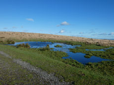
Hangershell Ancient Pool
OS Map: SX 65824 59588
HER: MDV127209
ShortName: PO:Hangershell
Notes: "A pool, one of over 40 such 'sacred' pools identified on Dartmoor that are thought to have potentially been designed during the prehistoric period. Lies near a prehistoric cairn. Sub-rectangular shallow pit of 12 metres by 16 metres and 0. 5 metres deep. Drained to west and east edges which show the remains of peat cutting"
Nearby sites: SX 65824 59588
Distance: 1.99km
Hangershell Rock (East of) Cairn
OS Map: SX 65662 59404
HER: MDV3124
Megalithic Portal: 4615
Alternate name: Butterdon Ridge N. Cairn
ShortName: CN Butterdon 2
Butler map: 53.8.2
Grinsell: UGB 15
Barrow Report: 61
Notes: East of hangershell rock large cairn with hollow centre. Diameter 17m, height 1.2m.
Nearby sites: SX 65662 59404
Distance: 1.89km
Harford Gate Encircled Cairn
Prehistoric Dartmoor Walks: Dartmoor Walk: The Neolithic tombs of Cuckoo Ball & Corringdon Ball
OS Map: SX 64494 59677
HER: MDV13092
Megalithic Portal: 3281
Alternate name: Piles Hill S.W.9 Encircled Cairn
ShortName: EC HarfordGate
Butler map: 53.11.9
Grinsell: HAR 26
Turner: F3
Notes: "This cairn occupies a prominent position on the brow of a hill and is one of two north-west of Harford Moor Gate. Measures 13 metres in diameter and 0.3 metres in height, it is turf-covered and has a retaining kerb." Visited by the author 20/04/19. Garmin gives location as SX 64495 59682 but a Lidar source gives location as SX 64494 59677 - which matches closely the HER NGR.
Nearby sites: SX 64494 59677
Distance: 0.73km
Harford Moor Settlement
Prehistoric Dartmoor Walks: Dartmoor Walk: The Neolithic tombs of Cuckoo Ball & Corringdon Ball
OS Map: SX 6445 5931
HER: MDV2849
Megalithic Portal: 23440
ShortName: ST HarfordMoor
Notes: On the western side of Harford Moor reservoir.
Nearby sites: SX 6445 5931
Distance: 0.96km
Lower Piles Enclosed Settlement
Prehistoric Dartmoor Walks: Dartmoor Walk: The Neolithic tombs of Cuckoo Ball & Corringdon Ball
OS Map: SX 64396 60528
HER: MDV4354
Megalithic Portal: 45580
ShortName: ES:Lower Piles
Notes: "Within the newtake known as lower piles. A group of seven huts near the south east corner of the enclosed land. All now composed of fairly small stones the walls appearing as thick banks of stone and turf, not high, but spreading to a width of 1.8m or more. The diameters vary from c 9.20 to c 12.20m outside measurements. Only one hut has a well defined entrance, this is on the south east side of the circle."
Nearby sites: SX 64396 60528
Distance: 0.66km
Lower Piles Ring Setting Cairn and Cist
Prehistoric Dartmoor Walks: Dartmoor Walk: The Neolithic tombs of Cuckoo Ball & Corringdon Ball
OS Map: SX 64540 60262
HER: MDV4256
Megalithic Portal: 1108
PMD: Lower Piles
Alternate name: Piles Hill S.W.15 Ring Setting Cairn and Cist
ShortName: CT Lower Piles
Butler map: 53.11.15
DPD page: 76
Grinsell: HAR 8
Turner: D13
Barrow Report: 36 62
Notes: "A cist with a retaining circle, diameter 14 to 15 feet, of which seven stones still remain, lies about 150 yds south of the south east angle of Lower Piles enclosure. The cist measures 3 feet 7 inches in length by 1 foot 4 inches wide at the south-eastern end and 2 feet wide at the north western. The present depth is from 2 feet 9 inches to 3 feet. The cover-stone and the north-western end-stone are missing." Letchfield diagram p.76. Barrow Report 36 says "To the south-east, in the direction of the length of the kistvaen, stands a single large stone, about 100 feet distant; to the north-west, with its centre 110 feet away from the centre of the kistvaen, there is a small cairn of 20 feet diameter; this also is in the line of the length of the kistvaen." The stone is at SX 64518 60236 Butler Piles Hill S.W. - Vol. 4. Map 53.11.15 (p.33 diagram of cist & plan of cairns on Piles Hill p.30).
Nearby sites: SX 64540 60262
Distance: 0.66km
Piles Hill Standing Stone
Prehistoric Dartmoor Walks: Dartmoor Site: Piles Hill Double Stone Row & Cairns
OS Map: SX 65433 60746
HER: MDV5653
Megalithic Portal: 10003
PMD: Piles Hill Standing Stone
ShortName: SS Piles Hill
Butler map: 53.8
DPD page: 77
Notes: The fallen menhir on Piles Hill: "The 'Longstone' is a block of very coarse-grained pinkish granite. It is now 2.5m long and of rough rectangular section tapering from a base formerly about 0.4m. by 0.7m. which has been squared and snapped by drilling. The stone lies in a northwest to southeast direction. To its northeast side there is a boundary stone erected in 1803 and shaped by drilling. It is of identical stone and appears to have been fashioned from the 'Longstone' which would therefore have originally been some 4.5m long." Lethbridge p.77
Nearby sites: SX 65433 60746
Distance: 1.66km
Piles Hill Stone Ring Cairn Circle
OS Map: SX 65334 60849
HER: MDV5763
Megalithic Portal: 10030
Alternate name: Piles Hill Summit Stone Ring Cairn Circle
ShortName: RC:Piles Hill
Butler map: 54.19
Butler Vol 5: p.162 & Fig.103
Grinsell: HAR 12
Turner: A53
Notes: Bell cairn of Wessex type. "Cairn on piles hill. An unusual monument, the equivalent of a bell barrow in stone. Cairn (diam 17.8m, heig 1.37m), berm(widt 3.05m), stone circle (diam 2.1m, heig 457mm)vis=12/4/1950 (os). Cairn with bell disc features. Slight hollow in the centre of the tump (mound), otherwise in good condition. No distinct outer bank could be found, but the berm and central tump were quite evident."
Nearby sites: SX 65334 60849
Distance: 1.62km
Piles Hill Stone Row
Prehistoric Dartmoor Walks: Dartmoor Site: Piles Hill Double Stone Row & Cairns
OS Map: SX 65016 61113
HER: MDV5662
Megalithic Portal: 2080
The Stone Rows of GB: Piles Hill
PMD: Piles Hill Stone Row
ShortName: SR Piles Hill
Butler map: 54.19
DPD page: 74
Notes: "The double stone row formed by 139 stones, 7 of which lean; the others are either stumps with drill marks, cleanly snapped off stones, or recumbent posts, whole or split by drilling. Some 30 stones exceed 2.0m. in length with a maximum of 3.0m. A few take the form of slabs or boulders but the majority are of post-type up to 0.6m. square in section, with an angled top created by a single 'chamfer'. The rows in the main alignment are from 21.0m. to 30.0m. apart and within them the gaps between stones vary from 3.0m. to 30.0m. At each end the rows are close, 12.0m. to 17.0m. apart with fewer large gaps between stones". Lethbridge pp.74-6, diagram p.74.
Nearby sites: SX 65016 61113
Distance: 1.51km
Spurrell's Cross Stone Row
Prehistoric Dartmoor Walks: Dartmoor Walk: The Erme East stone rows
OS Map: SX 65860 59862
HER: MDV2890
Megalithic Portal: 2137
The Stone Rows of GB: Spurrells Cross
PMD: Spurrells Cross Stone Row
Alternate name: Spurrell's Cross Stone Row
ShortName: SR Spurrells X
Butler map: 53.10
DPD page: 78
Notes: "The row has apparently been double, but since only seven stones still stand, which together with six sunken stones form the fixed points now determinable, it is difficult to ascertain the original spacing. The lines were probably about 3 feet 6 inches apart and the spacing between the stones about 3 feet. The length of the row is 370 feet as measured from the centre of the cairn and the direction of length is N 20o W. The largest standing stone is 2 feet in height. The cairn, at the south end of the row is 50 feet in diameter with only two stones remaining of the retaining circle". Lethbridge p.78, diagram p.77 Row 3. The photo here is most probably not of the row. The row runs parallel to Butterdon row and does not orientate on Spurrel's Cross.
Nearby sites: SX 65860 59862
Distance: 1.97km
Spurrells Ancient Pool
OS Map: SX 65810 60059
HER: MDV127224
ShortName: PO:Spurrells
Notes: "A pool measuring around 18m. One of over 40 such 'sacred' pools identified on Dartmoor that are thought to have potentially been designed during the prehistoric period. Lies to the north of a stone row. Livestock watering pond modified by peat cutting of 25 metres by 16 metres and 0.4 metres deep. The edges show the remains of peat cutting"
Nearby sites: SX 65810 60059
Distance: 1.91km
Spurrells Cross Encircled Cairn
Prehistoric Dartmoor Walks: Dartmoor Walk: The Erme East stone rows
OS Map: SX 65858 59864
HER: MDV2891
Megalithic Portal: 1273
PMD: Spurrell's Cross Stone Row
Alternate name: Spurrell's cross stone row Encircled Cairn
ShortName: EC:Spurrells X
Butler map: 53.10
Grinsell: UGB 12
Turner: F9
Barrow Report: 56
Notes: Cairn at SX 65855985, 12 metres in diameter by 0.4 metres high, with two stones of retaining circle, from which double stone row descends to north north west. This cairn is located about 125 metres from Spurrells Cross.
Nearby sites: SX 65858 59864
Distance: 1.97km
Stalldown Enclosed Settlement
Prehistoric Dartmoor Walks: Dartmoor Site: Stalldown Stone Row
OS Map: SX 63665 61217
HER: MDV4351
Megalithic Portal: 45322
ShortName: ES Stalldown
Notes: "This settlement consists of 6 enclosures, mostly in poor condition, with 13 associated hut circles and 17 detached ones and extends over 5ha of a gentle to moderate, well drained, southeast facing slope at 270m above OD."
Nearby sites: SX 63665 61217
Distance: 1.14km
Stalldown (South east) Enclosed Settlement
OS Map: SX 64197 61558
HER: MDV4348
ShortName: ES:StalldownSE
Notes: HER: Small enclosure with a hut circle in the Erme Valley shown as 'Homestead' on modern mapping
Nearby sites: SX 64197 61558
Distance: 1.49km
Stalldown Row Terminal Cairn Circle
Prehistoric Dartmoor Walks: Dartmoor Site: Stalldown Stone Row
OS Map: SX 63176 61737
Megalithic Portal: 531
PMD: Staldon Stone Row
ShortName: CC StallTermin
Butler Vol 5: p.20 & Fig.2
Notes: Unconfirmed terminal cairn. Not listed on HER or NMR
Nearby sites: SX 63176 61737
Distance: 1.79km
Weatherdon Hill Stone Ring Cairn Circle
OS Map: SX 6516 5889
HER: MDV13165
Megalithic Portal: 45835
Alternate name: Wetherdon Hill 20 Stone Ring Cairn Circle
ShortName: RC:Wetherdon20
Butler map: 53.9.20
Grinsell: HAR 14a
Turner: A28
Notes: "Weatherdon hill (4): diameter approx.5.6m ht. Approx 0.15m. Alt. C.335-340m." "Mr. L. V. Grinsell noted a small cairn-circle or ring-cairn a short distance south of cairn 2 on weatherdon hill."
Nearby sites: SX 6516 5889
Distance: 1.75km