
Prehistoric sites within 3km of SX 56970 61000
Guidance for walkers: The monuments featured in this database are archaeological treasures and need to be protected and preserved - please do not disturb any sites. Please check access and firing times before visiting sites, not all sites listed are on open access land. Firing ranges and boundaries of open access areas are marked on the OL28 OS Dartmoor Explorer map. Please stick to the country code and consider giving support to the numerous agencies that help to keep Dartmoor a fabulous natural and historic environment!
About the database listings: In all listings clicking on the photo or the site name will open a page for the site with a larger photo and further details from the database. The database now has over 6680 records covering nearly all publicly listed sites on Dartmoor including around 4800 round houses. This level of detail is of interest to archaeologists but tends to swamp listings of sites more likely to be of interest for walkers. For this reason, the listings default to around 550 core sites only. These are the stone circles, stone rows and the ring cairns listed by Turner. The default search radius is 2 km. The controls below the map can be used to start a new search by entering a 6- or 8-digit reference (without the prefix "SX"). The search radius can be specified and you can add incremental Display layers of detail on top of the core sites. If using a more detailed layer you will need to decrease the search radius to avoid getting hundreds of search results.
- Core sites Default listing of core sites consisting of stone circles & rows and some of the major ring cairns.
- Plus cairns adds approx. 1000 cairns and other minor sites not included in the core listings but excluding round houses.
- Plus round houses adds approx. 4800 round houses.
- Plus non-sites adds in the records for sites that no longer exist or are not prehistoric sites.
- Plus duplicates adds records excluded as duplicates. Those maybe duplicate records in external listings (e.g. the Historic Environment Records). For example, some sites have been identified as cairns in some listings and interpreted as round houses in other listings and both records appear.
These listings have incorporated, matched up and merged all of the records from all of the major archaeological listings including: Worth, Grinsell, Turner, Butler, Bill Radcliffe, Sandy Gerrard, Megalithic Portal, the National Monument Records and the Historic Environment Records. The author would like to thank Bill, Sandy, the lovely people both at Megalithic Portal (especially Anne Tate who did an amazing job to link listings) and at ACE Archaeology for collaborative work over the years to synchronise and correct listings across the various websites which now interlink. A culmination of years of work the final merger of cairn records took 3 months of cross referencing in 2017 the result being a snapshot of the records at that time. This data has in turn been refined since by field work and research. The round house data was supplied by Sandy Gerrard. Grid references are in order of accuracy: from Google Earth satellite, if visible and found, from a Garmin GPS reading, if visited by the author and from the literature otherwise. Individual site pages will state the source of the grid reference and provide satellite imagery. If a site listing lacks a photo it has not yet been visited by the author in which case the grid reference is from the literature.
Currently the database only includes sites which can be represented by a grid reference. Reaves are not included as they require GIS shape technology which is beyond the current capability of this system. To see the sources for the records, look at the tables on the resources menu. The database listings can also be viewed on a Google map and downloaded as GPS datasets for Garmin devices.
Corrections, or any feedback or suggestions are very welcome, email: info@dartmoorwalks.org.uk.
NOTE: Clicking on the icons for each monument in the map will give the name of the site. You can zoom in and out and drag the map around.
List of sites within 3km of SX 56970 61000
Parkland Round House
OS Map: SX 59582 62037
HER: MDV2562
ShortName: HT:Parkland1
Nearby sites: SX 59582 62037
Distance: 2.81km
Parkland Round House
OS Map: SX 59602 61886
HER: MDV5540
ShortName: HT:Parkland2
Nearby sites: SX 59602 61886
Distance: 2.78km
Parkland Round House
OS Map: SX 59602 62016
HER: MDV2562
ShortName: HT:Parkland3
Nearby sites: SX 59602 62016
Distance: 2.82km
Parkland Round House
OS Map: SX 59593 61971
HER: MDV2562
ShortName: HT:Parkland4
Nearby sites: SX 59593 61971
Distance: 2.80km
Parkland Round House
OS Map: SX 59592 62023
HER: MDV2562
ShortName: HT:Parkland5
Nearby sites: SX 59592 62023
Distance: 2.81km
Parkland Round House
OS Map: SX 59591 61899
HER: MDV5540
ShortName: HT:Parkland6
Nearby sites: SX 59591 61899
Distance: 2.77km
Parkland Round House
OS Map: SX 59605 61942
HER: MDV2562
ShortName: HT:Parkland7
Nearby sites: SX 59605 61942
Distance: 2.80km
Parkland Round House
OS Map: SX 59384 62162
HER: MDV2563
ShortName: HT:Parkland8
Nearby sites: SX 59384 62162
Distance: 2.68km
Wotter Moor Cairn
OS Map: SX 552 622
HER: MDV48885
ShortName: CN:Wotter Moor
Nearby sites: SX 552 622
Distance: 2.14km
Parkland Round House
OS Map: SX 59615 61942
HER: MDV2562
ShortName: HT:Parkland9
Nearby sites: SX 59615 61942
Distance: 2.81km
Parkland Round House
OS Map: SX 59076 62223
HER: MDV79185
ShortName: HT:Parkland10
Nearby sites: SX 59076 62223
Distance: 2.44km
Parkland Round House
OS Map: SX 59076 62262
HER: MDV79185
ShortName: HT:Parkland11
Nearby sites: SX 59076 62262
Distance: 2.46km
Parkland Round House
OS Map: SX 59044 62221
HER: MDV79185
ShortName: HT:Parkland12
Nearby sites: SX 59044 62221
Distance: 2.41km
Parkland Round House
OS Map: SX 59069 62231
HER: MDV79185
ShortName: HT:Parkland13
Nearby sites: SX 59069 62231
Distance: 2.43km
Parkland Round House
OS Map: SX 59064 62221
HER: MDV79185
ShortName: HT:Parkland14
Nearby sites: SX 59064 62221
Distance: 2.42km
Parkland Round House
OS Map: SX 59054 62226
HER: MDV79185
ShortName: HT:Parkland15
Nearby sites: SX 59054 62226
Distance: 2.42km
Parkland Round House
OS Map: SX 59055 62262
HER: MDV79185
ShortName: HT:Parkland16
Nearby sites: SX 59055 62262
Distance: 2.44km
Parkland Round House
OS Map: SX 59233 62294
HER: MDV79185
ShortName: HT:Parkland17
Nearby sites: SX 59233 62294
Distance: 2.61km
Parkland Round House
OS Map: SX 59378 62165
HER: MDV2563
ShortName: HT:Parkland18
Nearby sites: SX 59378 62165
Distance: 2.68km
Parkland Round House
OS Map: SX 59382 62142
HER: MDV2563
ShortName: HT:Parkland19
Nearby sites: SX 59382 62142
Distance: 2.67km
Parkland Round House
OS Map: SX 59526 62101
HER: MDV2562
ShortName: HT:Parkland20
Nearby sites: SX 59526 62101
Distance: 2.78km
Tory Brookhead 1 Cairn
OS Map: SX 5888 6304
HER: MDV12938
ShortName: CN?ToryBrook1
Butler map: 51.7.1
Notes: A hut circle converted to a cairn accordig o Butler.
Nearby sites: SX 5888 6304
Distance: 2.79km
Parkland Round House
OS Map: SX 59016 62369
HER: MDV79185
ShortName: HT:Parkland21
Nearby sites: SX 59016 62369
Distance: 2.46km
Tory Brookhead 2 Cairn
OS Map: SX 58337 63413
HER: MDV5633
ShortName: CN:ToryBrook2
Butler map: 51.7.2
Grinsell: SHA 38
Nearby sites: SX 58337 63413
Distance: 2.77km
Parkland Round House
OS Map: SX 59473 62135
HER: MDV2563
ShortName: HT:Parkland22
Nearby sites: SX 59473 62135
Distance: 2.75km
Parkland Round House
OS Map: SX 5961 6193
HER: MDV2562
ShortName: HT:Parkland23
Nearby sites: SX 5961 6193
Distance: 2.80km
Parkland Round House
OS Map: SX 59409 62126
HER: MDV2563
ShortName: HT:Parkland24
Nearby sites: SX 59409 62126
Distance: 2.69km
Parkland Round House
OS Map: SX 59374 62167
HER: MDV2563
ShortName: HT:Parkland25
Nearby sites: SX 59374 62167
Distance: 2.67km
Parkland Round House
OS Map: SX 59389 62160
HER: MDV2563
ShortName: HT:Parkland26
Nearby sites: SX 59389 62160
Distance: 2.68km
Parkland Round House
OS Map: SX 59515 62115
HER: MDV2562
ShortName: HT:Parkland27
Nearby sites: SX 59515 62115
Distance: 2.78km
Parkland Round House
OS Map: SX 59504 62098
HER: MDV2562
ShortName: HT:Parkland28
Nearby sites: SX 59504 62098
Distance: 2.76km
Parkland Round House
OS Map: SX 59026 62277
HER: MDV79185
ShortName: HT:Parkland29
Nearby sites: SX 59026 62277
Distance: 2.42km
Parkland Round House
OS Map: SX 59097 62175
HER: MDV79185
ShortName: HT:Parkland30
Nearby sites: SX 59097 62175
Distance: 2.43km
Parkland Round House
OS Map: SX 59538 62074
HER: MDV2562
ShortName: HT:Parkland31
Nearby sites: SX 59538 62074
Distance: 2.78km
Parkland Round House
OS Map: SX 59554 62065
HER: MDV2562
ShortName: HT:Parkland32
Nearby sites: SX 59554 62065
Distance: 2.79km
Parkland Round House
OS Map: SX 59561 61945
HER: MDV2562
ShortName: HT:Parkland33
Nearby sites: SX 59561 61945
Distance: 2.76km
Parkland Round House
OS Map: SX 59564 62050
HER: MDV2562
ShortName: HT:Parkland34
Nearby sites: SX 59564 62050
Distance: 2.80km
Penn Beacon (SW) Cairn
OS Map: SX 5958 6242
HER: MDV48899
ShortName: CN:Penn Beac1
Turner: A56
Notes: Stone ring encircling natural rock.24m in diameter with bank 1m wide and 0.3m high. Only a few boulders remain.
Nearby sites: SX 5958 6242
Distance: 2.97km
List A SHAUGH PRIOR 1 Reported Cairn
OS Map: SX 5493 6213
HER: MDV-1
ShortName: CNxList A SH1
Grinsell: A:SHA 1
Notes: Post-medieval boundary marker, An upright moorstone granite slab,thought by Rowe to be remains of Dolmen
Nearby sites: SX 5493 6213
Distance: 2.33km
Tory Brookhead Round House
OS Map: SX 58618 63334
HER: MDV2425
ShortName: HT:Tory Broo1
Nearby sites: SX 58618 63334
Distance: 2.86km
Tory Brookhead Round House
OS Map: SX 58628 63336
HER: MDV2425
ShortName: HT:Tory Broo2
Nearby sites: SX 58628 63336
Distance: 2.86km
Tory Brookhead Round House
OS Map: SX 58499 63388
HER: MDV53383
ShortName: HT:Tory Broo3
Nearby sites: SX 58499 63388
Distance: 2.84km
Tory Brookhead Round House
OS Map: SX 58499 63395
HER: MDV53383
ShortName: HT:Tory Broo4
Nearby sites: SX 58499 63395
Distance: 2.84km
Tory Brookhead Round House
OS Map: SX 58624 63304
HER: MDV2432
ShortName: HT:Tory Broo5
Nearby sites: SX 58624 63304
Distance: 2.84km
Tory Brookhead Round House
OS Map: SX 58526 63338
HER: MDV2427
ShortName: HT:Tory Broo6
Nearby sites: SX 58526 63338
Distance: 2.81km
Tory Brookhead Round House
OS Map: SX 58612 63330
HER: MDV2425
ShortName: HT:Tory Broo7
Nearby sites: SX 58612 63330
Distance: 2.85km
Penn Beacon S.W.7 Reported Cairn
OS Map: SX 5948 6257
ShortName: CN:Penn Beac13
Butler map: 52.14.7
Notes: ?
Nearby sites: SX 5948 6257
Distance: 2.96km
Tory Brookhead Round House
OS Map: SX 58619 63328
HER: MDV2425
ShortName: HT:Tory Broo8
Nearby sites: SX 58619 63328
Distance: 2.85km
Penn Beacon S.W.8 Cairn
OS Map: SX 5949 6258
HER: MDV12915
ShortName: CN:Penn Beac14
Butler map: 52.14.8
Nearby sites: SX 5949 6258
Distance: 2.97km
Tory Brookhead Round House
OS Map: SX 58606 63373
HER: MDV2425
ShortName: HT:Tory Broo9
Nearby sites: SX 58606 63373
Distance: 2.88km
Penn Beacon S.W.9 Reported Cairn
OS Map: SX 5941 6258
ShortName: CN:Penn Beac15
Butler map: 52.14.9
Nearby sites: SX 5941 6258
Distance: 2.91km
Tory Brookhead Round House
OS Map: SX 58629 63348
HER: MDV2425
ShortName: HT:Tory Broo10
Nearby sites: SX 58629 63348
Distance: 2.87km
Penn Beacon S.W.10 Reported Cist
OS Map: SX 59431 62663
HER: MDV12914
PMD: Penn Beacon 10
ShortName: CN Penn Beac8
Butler map: 52.14.10
Butler Vol 5: p.26 & Fig.7
Notes: Cairn 10 survives as a ring of stones only, ten small slabs, several of them overgrown, arranged in a circle about 3.0m across. The upper edge of a narrow slab protruding through the turf near the centre is in the correct position for the end stone of a cist. (Butler Vol. 3 p.193) n.b. Radcliffe points out that Butler incorrectly lists Vol 5 Fig 6, p25 for this cairn, it has been corrected in this listing to Fig 7. p26
Nearby sites: SX 59431 62663
Distance: 2.97km
Tory Brookhead Round House
OS Map: SX 58616 63361
HER: MDV2425
ShortName: HT:Tory Broo11
Nearby sites: SX 58616 63361
Distance: 2.88km
Penn Beacon S.W.11 Reported Cairn
OS Map: SX 5934 6274
ShortName: CN:Penn Beac9
Butler map: 52.14.11
Nearby sites: SX 5934 6274
Distance: 2.94km
Tory Brookhead Round House
OS Map: SX 58614 63355
HER: MDV2425
ShortName: HT:Tory Broo12
Nearby sites: SX 58614 63355
Distance: 2.87km
Penn Beacon S.W.12 Reported Cairn
OS Map: SX 5936 6274
ShortName: CN:Penn Beac10
Butler map: 52.14.12
Notes: Butler: one of a pair (with cairn 11), "the companion mound a few metres uphill has been reduced to an oval shape by the removal of half of it's structure, the arc of stones foooting the upper part alone remaining".
Nearby sites: SX 5936 6274
Distance: 2.96km
Tory Brookhead Round House
OS Map: SX 58495 63392
HER: MDV53383
ShortName: HT:Tory Broo13
Nearby sites: SX 58495 63392
Distance: 2.84km
Penn Beacon W.13 Reported Cairn
OS Map: SX 5930 6287
ShortName: CN:Penn Beac18
Butler map: 52.14.13
Nearby sites: SX 5930 6287
Distance: 2.99km
Tory Brookhead Round House
OS Map: SX 58755 63324
HER: MDV53394
ShortName: HT:Tory Broo14
Nearby sites: SX 58755 63324
Distance: 2.93km
Tory Brookhead Round House
OS Map: SX 58494 63388
HER: MDV53383
ShortName: HT:Tory Broo15
Nearby sites: SX 58494 63388
Distance: 2.83km
Tory Brookhead Round House
OS Map: SX 58478 63375
HER: MDV2426
ShortName: HT:Tory Broo16
Nearby sites: SX 58478 63375
Distance: 2.81km
Tory Brookhead Round House
OS Map: SX 58476 63352
HER: MDV53392
ShortName: HT:Tory Broo17
Nearby sites: SX 58476 63352
Distance: 2.79km
Penn Beacon W.17 Cairn
OS Map: SX 592 629
HER: MDV12910
ShortName: CN:Penn Beac22
Butler map: 52.14.17
Notes: Many of the Butler Penn Beacon cairns could match HER 12910 - this one is closer!
Nearby sites: SX 592 629
Distance: 2.93km
Tory Brookhead Round House
OS Map: SX 58630 63369
HER: MDV2425
ShortName: HT:Tory Broo18
Nearby sites: SX 58630 63369
Distance: 2.89km
Tory Brookhead Round House
OS Map: SX 58556 63335
HER: MDV2428
ShortName: HT:Tory Broo19
Nearby sites: SX 58556 63335
Distance: 2.82km
Tory Brookhead Round House
OS Map: SX 58451 63413
HER: MDV63334
ShortName: HT:Tory Broo20
Nearby sites: SX 58451 63413
Distance: 2.83km
Tory Brookhead Round House
OS Map: SX 58549 63333
HER: MDV2428
ShortName: HT:Tory Broo21
Nearby sites: SX 58549 63333
Distance: 2.82km
Crownhill Tor Fields Reported Cairn
OS Map: SX 5736 6079
HER: MDV12927
ShortName: CNxCrownhill21
Butler map: 52.16.1
Notes: Probably a clearance mound
Nearby sites: SX 5736 6079
Distance: 0.44km
Tory Brookhead Round House
OS Map: SX 58627 63325
HER: MDV2425
ShortName: HT:Tory Broo22
Nearby sites: SX 58627 63325
Distance: 2.86km
Crownhill Down W.5 Cairn
OS Map: SX 5625 5981
HER: MDV12658
ShortName: CN:Crownhill2
Butler map: 52.16.5
Nearby sites: SX 5625 5981
Distance: 1.39km
Tory Brookhead Round House
OS Map: SX 58609 63316
HER: MDV2431
ShortName: HT:Tory Broo23
Nearby sites: SX 58609 63316
Distance: 2.84km
Crownhill Down W.6 Cairn
OS Map: SX 5679 5988
HER: MDV20151
ShortName: CN:Crownhill3
Butler map: 52.16.6
Grinsell: SHA 47
Notes: Cairn with hollow at centre found on sparkwell boundary.
Nearby sites: SX 5679 5988
Distance: 1.13km
Tory Brookhead Round House
OS Map: SX 58578 63341
HER: MDV53390
ShortName: HT:Tory Broo24
Nearby sites: SX 58578 63341
Distance: 2.84km
Crownhill Down Reported Cist
OS Map: SX 57 60
ShortName: CT?Crownhill1
Butler map: 52.16.6
Grinsell: SPA 8a
Notes: From a barrow 'destroyed many years since' came a large flint scraper and flint flakes PLYM Brent 1886. See. TDA 1886 Vol 18 p.74. Butler suggests that perhaps Brent's cairn was either 52.16.5 or 52.16.6.
"Crown Hill Down.—Amongst the rubbish and stones that had been removed and thrown down from a large circular barrow, that had been destroyed many years since, I found a large rude scraper of flint, and some broken pieces, all much weathered from exposure"
Nearby sites: SX 57 60
Distance: 1.00km
Tory Brookhead Round House
OS Map: SX 58609 63378
HER: MDV2425
ShortName: HT:Tory Broo25
Nearby sites: SX 58609 63378
Distance: 2.89km
Crownhill Ridge 1 Cairn
OS Map: SX 5723 5973
HER: MDV1788
ShortName: CN:Crownhill4
Butler map: 52.16.7.1
Grinsell: SPA 7
Notes: NMR I
Nearby sites: SX 5723 5973
Distance: 1.30km
Tory Brookhead Round House
OS Map: SX 58635 63346
HER: MDV2425
ShortName: HT:Tory Broo26
Nearby sites: SX 58635 63346
Distance: 2.88km
Crownhill Ridge 2 Cairn
OS Map: SX 5723 5975
HER: MDV1787
ShortName: CN:Crownhill9
Butler map: 52.16.7.2
Grinsell: SPA 6
Notes: NMR H
Nearby sites: SX 5723 5975
Distance: 1.28km
Tory Brookhead Round House
OS Map: SX 58670 63348
HER: MDV2425
ShortName: HT:Tory Broo27
Nearby sites: SX 58670 63348
Distance: 2.90km
Crownhill Ridge 3 Cairn
OS Map: SX 57235 59778
HER: MDV1786
ShortName: CN:Crownhill10
Butler map: 52.16.7.3
Grinsell: SPA 5
Notes: NMR G
Nearby sites: SX 57235 59778
Distance: 1.25km
Tory Brookhead Round House
OS Map: SX 58638 63355
HER: MDV2425
ShortName: HT:Tory Broo28
Nearby sites: SX 58638 63355
Distance: 2.89km
Crownhill Ridge 4 Cairn
OS Map: SX 5720 5978
HER: MDV1785
ShortName: CN:Crownhill11
Butler map: 52.16.7.4
Grinsell: SPA 4
Notes: NMR F
Nearby sites: SX 5720 5978
Distance: 1.24km
Tory Brookhead Round House
OS Map: SX 58627 63352
HER: MDV2425
ShortName: HT:Tory Broo29
Nearby sites: SX 58627 63352
Distance: 2.88km
Crownhill Ridge 5 Cairn
OS Map: SX 5719 5981
HER: MDV1784
ShortName: CN:Crownhill12
Butler map: 52.16.7.5
Grinsell: SPA 3
Notes: NMR E
Nearby sites: SX 5719 5981
Distance: 1.21km
Tory Brookhead Round House
OS Map: SX 58647 63366
HER: MDV2425
ShortName: HT:Tory Broo30
Nearby sites: SX 58647 63366
Distance: 2.90km
Crownhill Ridge 6 Cairn
OS Map: SX 5719 5983
HER: MDV1783
ShortName: CN:Crownhill13
Butler map: 52.16.7.6
Grinsell: SPA 2a
Notes: NMR D
Nearby sites: SX 5719 5983
Distance: 1.19km
Crownhill Ridge 7 Cairn
OS Map: SX 5718 5985
HER: MDV1782
ShortName: CN:Crownhill14
Butler map: 52.16.7.7
Grinsell: SPA 2
Notes: NMR C
Nearby sites: SX 5718 5985
Distance: 1.17km
Crownhill Ridge 8 Cairn
OS Map: SX 5718 5987
HER: MDV1781
ShortName: CN:Crownhill15
Butler map: 52.16.7.8
Grinsell: SPA 1a
Notes: NMR B
Nearby sites: SX 5718 5987
Distance: 1.15km
Crownhill Ridge 9 Cairn
OS Map: SX 5717 5993
HER: MDV11801
ShortName: CN:Crownhill16
Butler map: 52.16.7.9
Grinsell: SPA 1
Notes: NMR A
Nearby sites: SX 5717 5993
Distance: 1.09km
Crownhill Ridge 10 Cairn
OS Map: SX 5717 5996
HER: MDV76030
ShortName: CN:Crownhill5
Butler map: 52.16.7.10
Notes: Cairn J ? Mound 2 ?
Nearby sites: SX 5717 5996
Distance: 1.06km
Crownhill Ridge 11 Cairn
OS Map: SX 5718 6000
HER: MDV12699
ShortName: CN:Crownhill6
Butler map: 52.16.7.11
Notes: Cairn K ? Mound 3 ?
Nearby sites: SX 5718 6000
Distance: 1.02km
Crownhill Ridge 12 Cairn
OS Map: SX 5716 6000
HER: MDV12787
ShortName: CN:Crownhill7
Butler map: 52.16.7.12
Notes: Cairn L
Nearby sites: SX 5716 6000
Distance: 1.02km
Crownhill Ridge 13 Cairn
OS Map: SX 5716 6004
HER: MDV12939
ShortName: CN:Crownhill8
Butler map: 52.16.7.13
Notes: Cairn M ? Mound 1 ?
Nearby sites: SX 5716 6004
Distance: 0.98km
Hawkesborough Cairn
OS Map: SX 5724 5952
HER: MDV1802
ShortName: CN:Hawkesbor1
Butler map: 52.16.8
Grinsell: SPA 8
Nearby sites: SX 5724 5952
Distance: 1.50km
Crownhill Ridge S.1 Cairn
OS Map: SX 5740 6004
HER: MDV2554
ShortName: CN:Crownhill17
Butler map: 52.16.9.1
Nearby sites: SX 5740 6004
Distance: 1.05km
Crownhill Ridge S.2 Cairn
OS Map: SX 5739 6001
HER: MDV35820
ShortName: CN:Crownhill18
Butler map: 52.16.9.2
Nearby sites: SX 5739 6001
Distance: 1.08km
Crownhill Ridge S.3 Cairn
OS Map: SX 5740 6001
HER: MDV28078
ShortName: CN:Crownhill19
Butler map: 52.16.9.3
Nearby sites: SX 5740 6001
Distance: 1.08km
Crownhill Summit Cairn
OS Map: SX 5748 6025
HER: MDV12912
ShortName: CN:Crownhill20
Butler map: 52.16.10
Nearby sites: SX 5748 6025
Distance: 0.91km
Trowlesworthy Round House
OS Map: SX 5758 6384
HER: MDV32086
ShortName: HT:Trowles9
Nearby sites: SX 5758 6384
Distance: 2.90km
Ridding Down 1 Cairn
OS Map: SX 58043 61208
HER: MDV2560
ShortName: CN:Ridding D1
Butler map: 52.16.11
Grinsell: COR 7
Nearby sites: SX 58043 61208
Distance: 1.09km
Ridding Down 2 Cairn
OS Map: SX 58045 61359
HER: MDV2518
ShortName: CN:Ridding D2
Butler map: 52.16.12
Grinsell: COR 6
Nearby sites: SX 58045 61359
Distance: 1.13km
Saddlesborough pound A, wall cairn Reported Cairn
OS Map: SX 55931 63491
HER: MDV2440
ShortName: CN?Saddlesbo5
Butler map: 48.3
Butler Vol 5: p.101 & Fig.59
Notes: Butler describes a cairn-like structure within the enclosure wall of Pound A. "A small cairn-like erection 3.5 m across projecting into the interior from the outer wall was probably a style support for access into the pound". Viewing Pound A in Google earth and comparing with Butler's diagram Fig. 59 gives a location of SX 55931 63491.
Nearby sites: SX 55931 63491
Distance: 2.70km
Trowlesworthy Round House
OS Map: SX 57430 63944
HER: MDV28568
ShortName: HT:Trowles34
Nearby sites: SX 57430 63944
Distance: 2.98km
Shaugh Moor Round House
OS Map: SX 55841 63437
HER: MDV12779
ShortName: HT:Shaugh Mo1
Nearby sites: SX 55841 63437
Distance: 2.69km
Shaugh Moor Round House
OS Map: SX 55959 63510
HER: MDV2440
ShortName: HT:Shaugh Mo2
Nearby sites: SX 55959 63510
Distance: 2.71km
Shaugh Moor Round House
OS Map: SX 55709 63517
HER: MDV12951
ShortName: HT:Shaugh Mo3
Nearby sites: SX 55709 63517
Distance: 2.82km
Shaugh Moor Round House
OS Map: SX 55742 63475
HER: MDV12952
ShortName: HT:Shaugh Mo4
Nearby sites: SX 55742 63475
Distance: 2.76km
Shaugh Moor Round House
OS Map: SX 55751 63504
HER: MDV12952
ShortName: HT:Shaugh Mo5
Nearby sites: SX 55751 63504
Distance: 2.78km
Tory Brookhead 2 (duplicate) Reported Cairn
OS Map: SX 5833 6340
HER: MDV28541
ShortName: CN:ToryBrook6
Butler map: 51.7.2
Nearby sites: SX 5833 6340
Distance: 2.76km
Shaugh Moor Round House
OS Map: SX 55765 63487
HER: MDV12952
ShortName: HT:Shaugh Mo6
Nearby sites: SX 55765 63487
Distance: 2.76km
Shaugh Moor Round House
OS Map: SX 55772 63441
HER: MDV12779
ShortName: HT:Shaugh Mo7
Nearby sites: SX 55772 63441
Distance: 2.72km
Penn Beacon 1 stone row (duplicate) Reported Cist
OS Map: SX 59528 62475
HER: MDV2407
ShortName: CT:Penn Beac3
Butler map: 52.14.1
Notes: Duplicate of HER 12909
Nearby sites: SX 59528 62475
Distance: 2.95km
Shaugh Moor Round House
OS Map: SX 55791 63451
HER: MDV12779
ShortName: HT:Shaugh Mo8
Nearby sites: SX 55791 63451
Distance: 2.72km
Shaugh Moor Round House
OS Map: SX 56565 63645
HER: MDV2450
ShortName: HT:Shaugh Mo9
Nearby sites: SX 56565 63645
Distance: 2.68km
Shaugh Moor Round House
OS Map: SX 55809 63433
HER: MDV12779
ShortName: HT:Shaugh Mo10
Nearby sites: SX 55809 63433
Distance: 2.70km
Shaugh Moor Round House
OS Map: SX 56513 63694
HER: MDV2450
ShortName: HT:Shaugh Mo11
Nearby sites: SX 56513 63694
Distance: 2.73km
Shaugh Moor Round House
OS Map: SX 55909 63511
HER: MDV2440
ShortName: HT:Shaugh Mo12
Nearby sites: SX 55909 63511
Distance: 2.73km
Shaugh Moor Round House
OS Map: SX 55933 63527
HER: MDV2440
ShortName: HT:Shaugh Mo13
Nearby sites: SX 55933 63527
Distance: 2.73km
Shaugh Moor Round House
OS Map: SX 55671 63579
HER: MDV12951
ShortName: HT:Shaugh Mo14
Nearby sites: SX 55671 63579
Distance: 2.89km
Shaugh Moor Round House
OS Map: SX 55897 63541
HER: MDV2440
ShortName: HT:Shaugh Mo15
Nearby sites: SX 55897 63541
Distance: 2.76km
Shaugh Moor Round House
OS Map: SX 56553 63713
HER: MDV2450
ShortName: HT:Shaugh Mo16
Nearby sites: SX 56553 63713
Distance: 2.74km
Shaugh Moor Round House
OS Map: SX 56533 63715
HER: MDV2450
ShortName: HT:Shaugh Mo17
Nearby sites: SX 56533 63715
Distance: 2.75km
Shaugh Moor Round House
OS Map: SX 55693 63619
HER: MDV12951
ShortName: HT:Shaugh Mo18
Nearby sites: SX 55693 63619
Distance: 2.91km
Shaugh Moor Round House
OS Map: SX 55801 63490
HER: MDV12952
ShortName: HT:Shaugh Mo19
Nearby sites: SX 55801 63490
Distance: 2.75km
Shaugh Moor Round House
OS Map: SX 55242 62903
HER: MDV2590
ShortName: HT:Shaugh Mo20
Nearby sites: SX 55242 62903
Distance: 2.57km
Shaugh Moor Round House
OS Map: SX 55423 63384
HER: MDV2575
ShortName: HT:Shaugh Mo21
Nearby sites: SX 55423 63384
Distance: 2.84km
Shaugh Moor Round House
OS Map: SX 55416 63395
HER: MDV43443
ShortName: HT:Shaugh Mo22
Nearby sites: SX 55416 63395
Distance: 2.85km
Shaugh Moor Round House
OS Map: SX 55415 63410
HER: MDV43445
ShortName: HT:Shaugh Mo23
Nearby sites: SX 55415 63410
Distance: 2.87km
Shaugh Moor Round House
OS Map: SX 5537 6205
HER: MDV48881
ShortName: HT:Shaugh Mo24
Nearby sites: SX 5537 6205
Distance: 1.91km
Shaugh Moor Round House
OS Map: SX 5530 6208
HER: MDV48880
ShortName: HT:Shaugh Mo25
Nearby sites: SX 5530 6208
Distance: 1.99km
Shaugh Moor Round House
OS Map: SX 55307 62837
HER: MDV48895
ShortName: HT:Shaugh Mo26
Nearby sites: SX 55307 62837
Distance: 2.48km
Shaugh Moor Round House
OS Map: SX 55684 63585
HER: MDV12951
ShortName: HT:Shaugh Mo27
Nearby sites: SX 55684 63585
Distance: 2.89km
Shaugh Moor Round House
OS Map: SX 55288 63000
HER: MDV28536
ShortName: HT:Shaugh Mo28
Nearby sites: SX 55288 63000
Distance: 2.61km
Heap of Stones Reported Cairn
OS Map: SX 5860 5972
HER: MDV12651
ShortName: CN?Heap of S2
Notes: Destroyed
Nearby sites: SX 5860 5972
Distance: 2.07km
Shaugh Moor Round House
OS Map: SX 55474 63345
HER: MDV43444
ShortName: HT Shaugh Mo29
Nearby sites: SX 55474 63345
Distance: 2.78km
Heap of Stones (duplicate) Reported Cairn
OS Map: SX 5860 5972
HER: MDV12651
ShortName: CN?Heap of S3
Notes: Destroyed
Nearby sites: SX 5860 5972
Distance: 2.07km
Shaugh Moor Round House
OS Map: SX 55204 62885
HER: MDV2590
ShortName: HT:Shaugh Mo30
Nearby sites: SX 55204 62885
Distance: 2.58km
Emmets Post (W of) Reported Cairn
OS Map: SX 5673 6317
HER: MDV2439
ShortName: CN?Emmets Po2
Grinsell: B:SHA 42a
Barrow Report: 12
Nearby sites: SX 5673 6317
Distance: 2.18km
Shaugh Moor Round House
OS Map: SX 55188 62344
HER: MDV12950
ShortName: HT:Shaugh Mo31
Nearby sites: SX 55188 62344
Distance: 2.23km
Shaugh Moor Round House
OS Map: SX 55178 63030
HER: MDV2590
ShortName: HT:Shaugh Mo32
Nearby sites: SX 55178 63030
Distance: 2.71km
Trowelsworthy (NMR 439396) Reported Cairn
OS Map: SX 5743 6395
HER: MDV28568
ShortName: CNxTrowelswo1
Notes: Hut circle. NMR suggests ring cairn.
Nearby sites: SX 5743 6395
Distance: 2.99km
Shaugh Moor Round House
OS Map: SX 55170 62859
HER: MDV2590
ShortName: HT:Shaugh Mo33
Nearby sites: SX 55170 62859
Distance: 2.59km
Shaugh Prior (NMR 439468) Reported Cairn
OS Map: SX 557 608
HER: MDV2580
ShortName: CN?Shaugh Pr1
Notes: No trace of the supposed ring cairn could be found. The reference falls within an area which has been cleared in advance of the construction of a mica dam.
Nearby sites: SX 557 608
Distance: 1.29km
Shaugh Moor Round House
OS Map: SX 5515 6227
HER: MDV2591
ShortName: HT:Shaugh Mo34
Nearby sites: SX 5515 6227
Distance: 2.22km
Shaugh Moor Round House
OS Map: SX 55000 62908
HER: MDV48872
ShortName: HT:Shaugh Mo35
Nearby sites: SX 55000 62908
Distance: 2.74km
Shaugh Moor Round House
OS Map: SX 55297 62849
HER: MDV48895
ShortName: HT:Shaugh Mo36
Nearby sites: SX 55297 62849
Distance: 2.49km
Shaugh Moor Round House
OS Map: SX 55634 63465
HER: MDV12778
ShortName: HT:Shaugh Mo37
Nearby sites: SX 55634 63465
Distance: 2.80km
Shaugh Moor Round House
OS Map: SX 55673 63558
HER: MDV12951
ShortName: HT:Shaugh Mo38
Nearby sites: SX 55673 63558
Distance: 2.87km
Shaugh Moor Round House
OS Map: SX 55723 63522
HER: MDV12951
ShortName: HT:Shaugh Mo39
Nearby sites: SX 55723 63522
Distance: 2.81km
Shaugh Moor Round House
OS Map: SX 55664 63450
HER: MDV12778
ShortName: HT:Shaugh Mo40
Nearby sites: SX 55664 63450
Distance: 2.78km
Shaugh Moor Round House
OS Map: SX 55652 63491
HER: MDV12778
ShortName: HT:Shaugh Mo41
Nearby sites: SX 55652 63491
Distance: 2.82km
Shaugh Moor Round House
OS Map: SX 55652 63601
HER: MDV12951
ShortName: HT:Shaugh Mo42
Nearby sites: SX 55652 63601
Distance: 2.92km
Shaugh Moor Round House
OS Map: SX 55611 62251
HER: MDV2591
ShortName: HT:Shaugh Mo43
Nearby sites: SX 55611 62251
Distance: 1.85km
Shaugh Moor Round House
OS Map: SX 55427 62451
HER: MDV67979
ShortName: HT:Shaugh Mo44
Nearby sites: SX 55427 62451
Distance: 2.12km
Trowlesworthy Round House
OS Map: SX 5738 6380
HER: MDV32114
ShortName: HT:Trowles96
Nearby sites: SX 5738 6380
Distance: 2.83km
Saddlesborough N. Cairn
OS Map: SX 5589 6323
HER: MDV28564
ShortName: CN Saddlesbo3
Butler map: 48.3
Notes: The two entries SiteID=545 and SiteID=1472 are probably correct but the area is disturbed by tin workings and further confirmation is required that the correct features have been identified in the field (in terms of photos - visit 12 Sep 2022). Grid references not updated due to doubt about ID.
Nearby sites: SX 5589 6323
Distance: 2.48km
Shaugh Moor Round House
OS Map: SX 55638 63486
HER: MDV12778
ShortName: HT:Shaugh Mo45
Nearby sites: SX 55638 63486
Distance: 2.82km
Saddlesborough E.1 Cairn Circle
OS Map: SX 56015 63179
HER: MDV2553
ShortName: CN Saddlesbo1
Butler map: 48.3.1
Barrow Report: 7
Notes: "The remains of an impressive, though extensively disturbed ring cairn are located at SX56016317 on a gentle south-east facing slope 130 meters from the summit area of Saddlesborough at 298 meters above Ordnance Datum. It survives as an amorphous turf-covered ragged `rim' of stones." Possibly covered in Barrow Report 7.
Nearby sites: SX 56015 63179
Distance: 2.38km
Shaugh Moor Round House
OS Map: SX 55434 62457
HER: MDV67979
ShortName: HT:Shaugh Mo46
Nearby sites: SX 55434 62457
Distance: 2.12km
Saddlesborough E.2 Cairn
OS Map: SX 5607 6322
HER: MDV79252
ShortName: CN:Saddlesbo2
Butler map: 48.3.2
Nearby sites: SX 5607 6322
Distance: 2.40km
Shaugh Moor Round House
OS Map: SX 55631 63444
HER: MDV12778
ShortName: HT:Shaugh Mo47
Nearby sites: SX 55631 63444
Distance: 2.79km
Shaugh Moor Round House
OS Map: SX 55609 63433
HER: MDV12778
ShortName: HT:Shaugh Mo48
Nearby sites: SX 55609 63433
Distance: 2.79km
Shaugh Moor Round House
OS Map: SX 55596 63484
HER: MDV12953
ShortName: HT:Shaugh Mo49
Nearby sites: SX 55596 63484
Distance: 2.84km
Shaugh Moor Round House
OS Map: SX 55593 63469
HER: MDV12953
ShortName: HT:Shaugh Mo50
Nearby sites: SX 55593 63469
Distance: 2.83km
Shaugh Moor Round House
OS Map: SX 5555 6283
HER: MDV2449
ShortName: HT:Shaugh Mo51
Nearby sites: SX 5555 6283
Distance: 2.32km
Shaugh Moor Round House
OS Map: SX 55557 63454
HER: MDV12953
ShortName: HT:Shaugh Mo52
Nearby sites: SX 55557 63454
Distance: 2.83km
Shaugh Moor Round House
OS Map: SX 56575 63701
HER: MDV2450
ShortName: HT:Shaugh Mo53
Nearby sites: SX 56575 63701
Distance: 2.73km
Shaugh Moor Round House
OS Map: SX 55640 63441
HER: MDV12778
ShortName: HT:Shaugh Mo54
Nearby sites: SX 55640 63441
Distance: 2.78km
Shaugh Lake Reported Cairn
OS Map: SX 558 636
ShortName: CN?Shaugh La1
Butler map: 48.5
Grinsell: SHA 47a
Barrow Report: 15
Notes: SX 560 635. (approx.) A small barrow excavated by R H Worth in 1896 revealed little of interest beyond a platform or hearth of granite and a rounded flint
Nearby sites: SX 558 636
Distance: 2.85km
Collard Tor stone row 2 Cairn
OS Map: SX 5582 6203
HER: MDV2584
ShortName: CN Collard T3
Butler map: 48.6.2
Grinsell: SHA 45
Barrow Report: 22
Nearby sites: SX 5582 6203
Distance: 1.54km
Wotter Round House
OS Map: SX 55529 61870
HER: MDV2578
ShortName: HT:Wotter1
Nearby sites: SX 55529 61870
Distance: 1.68km
Wotter Round House
OS Map: SX 55479 61966
HER: MDV2578
ShortName: HT:Wotter2
Nearby sites: SX 55479 61966
Distance: 1.78km
Wotter Round House
OS Map: SX 55492 61856
HER: MDV2578
ShortName: HT:Wotter3
Nearby sites: SX 55492 61856
Distance: 1.71km
Emmets Post Cairn
OS Map: SX 56786 63196
HER: MDV2439
ShortName: CN:Emmets Po1
Butler map: 48.3
Grinsell: SHA 42
Barrow Report: 12
Notes: "Oxford Archaeology carried out an excavation of an early Bronze Age barrow at Emmets Post, Dartmoor in advance of its destruction by quarrying. The investigation elucidated the sequence of construction of the monument, which comprised a primary turf mound and a central cairn that were subsequently buried beneath a larger secondary turf mound with a stone kerb. No human remains were found, although this is not unusual on Dartmoor, where unburnt bone does not survive due to acidity of the soil."
See also Historic England: Emmets Post.
Nearby sites: SX 56786 63196
Distance: 2.20km
Boringdon Camp Fort
Prehistoric Dartmoor Walks: Dartmoor Resource: Table of Devon Iron Age Forts
OS Map: SX 54419 59637
HER: MDV1751
ShortName: FT:Boringdon
Nearby sites: SX 54419 59637
Distance: 2.89km
Cholwich Town Stone Row
OS Map: SX 585 623
HER: MDV2438
Megalithic Portal: 1824
The Stone Rows of GB: Cholwichtown
PMD: Cholwich Town Stone Row
Alternate name: Cholwichtown stone row Stone Row
ShortName: SRxCholwich
Butler map: 48.7
Notes: "This ring and stone row is now covered by china clay waste. A stone row and circle on top of a low ridge, between Tory Brook and a tributary of the Yealm, near Cholwich Town. The row, extending over 700ft, consisted of uprights 2-3ft. high and 3ft. apart, the circle, at the northern end of the row, was 15ft. in diameter with seven upright stones. The site was excavated in 1961, and the sockets of many missing stones were found, also a pit 8ft. in diameter in the centre of the circle." Pollen analysis suggested the row was originally in a clearing of a wooded area.
Nearby sites: SX 585 623
Distance: 2.01km
Cholwich Town (site of) Cairn Circle
OS Map: SX 5846 6225
HER: MDV49508
Megalithic Portal: 770
PMD: Cholwich Town Stone Row
Alternate name: Cholwichtown stone row Cairn Circle
ShortName: CCxCholwich
Butler map: 48.
Grinsell: COR 5
Turner: G27
Notes: Site of former cairn circle. "the row, extending over 700ft, consisted of uprights 2-3ft. high and 3ft. apart, the circle, at the northern end of the row, was 15ft. in diameter with seven upright stones. The site was excavated in 1961, and the sockets of many missing stones were found, also a pit 8ft. in diameter in the centre of the circle. "
Nearby sites: SX 5846 6225
Distance: 1.94km
Collard Tor Encircled Cairn
OS Map: SX 5584 6203
HER: MDV14793
Megalithic Portal: 794
PMD: Collard Tor
Alternate name: Collard Tor stone row 1 Encircled Cairn
ShortName: EC Collard Tor
Butler map: 48.6.1
DPD page: 57
Grinsell: SHA 46
Turner: F17
Barrow Report: 22
Notes: Cairn heading the easterly of the two Collard Tor rows. "The easterly cairn at SX 55846203 measures 8.1m. in diameter and 0.6m. high. The centre has been excavated, but apart from a large prone slab there is nothing to suggest a former cist. The mound is surrounded by a peristalith of boulders each of which is 0.9m. high and roughly 0.5m square. The row is similar to the other row and can be traced for 79.6m."
Nearby sites: SX 5584 6203
Distance: 1.53km
Collard Tor E. Stone Row
OS Map: SX 55849 62035
HER: MDV14792
Megalithic Portal: 1842
The Stone Rows of GB: Collard Tor East
PMD: Collard Tor E Stone Row
Alternate name: Collard Tor E Stone Row
ShortName: SR CollardTo E
Butler map: 48.6.2
DPD page: 57
Notes: Butler Collard Tor 1. "Two stone rows each headed by a cairn lie on a gentle clitter-covered south-facing hillslope between 239m and 259m above OD. The rows which are oriented approximately north-south, diverge from their northern ends and are from 17m to 19 apart; a field bank interrupts the course of the east row. The precise lengths of the rows are difficult to determine partly because they appear to have been slighted and partly because of the presence of clitter and earthfast stones which hamper identification of the individual stones. The deduced lengths of these rows (excluding the cairns) are 75.4m and up to 97.2m respectively however because of the disturbed nature of each row these measurements are by no means certain. A count of the upright and clearly definable stones revealed 10 in the west row and 13 in the east row, but these figures provide a totally misleading picture of the somewhat jumbled and chaotic distribution of moorstones in each alignment. The heights of the uprights range from 0.3m to 0.9m with one very large damaged stone 1.3m high. Both cairns have been badly disturbed: the western mound is 8m across and 0.6m high and the eastern mound is 8.5 m across and 0.6m high". Lethbridge pp.55-7, diagram p.55.
Nearby sites: SX 55849 62035
Distance: 1.53km
Collard Tor W. Stone Row
OS Map: SX 55833 62045
HER: MDV2583
Megalithic Portal: 1843
The Stone Rows of GB: Collard Tor West
PMD: Collard Tor W Stone Row
Alternate name: Collard Tor W Stone Row
ShortName: SR CollardTo W
Butler map: 48.6.1
DPD page: 57
Notes: Butler Collard Tor 2. Described in entry for Collard Tor E. Lethbridge pp.55-7, diagram p.55.
Nearby sites: SX 55833 62045
Distance: 1.54km
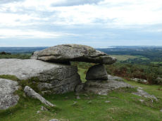
Hawk's Tor Rock Shelter
OS Map: SX 55348 62514
HER: MDV2504
Megalithic Portal: 45856
PMD: Hawk's Tor - Possible Chambered Tomb
ShortName: RS HawksTor
DPD page: 56
Grinsell: A:SHA 2
Barrow Report: 60
Notes: Natural feature Hawk's Tor rock shelter - resembles tomb. "At the summit stands a rock shelter, v shaped in plan with a coverstone. Rowe referred to it as a cromlech. R. N. Worth called it a natural grouping of rocks. Mr. Beckerlegge on examining the coverstone, found a similar vein of quartz in the coverstone as in the rocks of the v shaped shelter, but running in a different direction. The coverstone must have been levered or swung in an anti-clockwise direction through an angle of 90 degrees to make a shelter of what was previously an opening between two vertical walls of rock". Might be prehistoric, could be from Roman period or later. Lethbridge p.54-6 Hawk's Tor Cromlech / Rock Shelter - diagram p.55, photo p.56. See also: The Modern Antiquarian. The following is a sketch by R.H Worth. Detailed analysis by R.H. Worth in Barrow Report 60 in which he concludes the cover has been rotated.
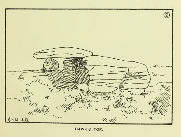
Nearby sites: SX 55348 62514
Distance: 2.22km
Penn Beacon 1 Cairn Circle & Cist
OS Map: SX 59532 62482
HER: MDV12909
PMD: Penn Beacon 1
Alternate name: Penn Beacon 1 stone row Cairn Circle & Cist
ShortName: CT Penn Beac2
Butler map: 52.14.1
DPD page: 61
Grinsell: COR 3
Notes: A cairn on the lower slope of Penn Beacon, close to stone row (sx56se/2). Opened in 1872 by Spence Bate and Oliver: a fine cist was found, a stone implement and many pot fragments, one quite substantial. The cairn stands at the north end of a double stone row which extends for 7.0m. The cist is not visible. See also: Bate's 1872 Report
Nearby sites: SX 59532 62482
Distance: 2.96km

Penn Beacon S.W. Stone Row
OS Map: SX 59523 62471
HER: MDV2399
Megalithic Portal: 2077
The Stone Rows of GB: Penn Beacon South West
PMD: Penn Beacon Cairn Stone Row
Alternate name: Penn Beacon SW Stone Row
ShortName: SR PennBeac SW
Butler map: 52.14.1
DPD page: 61
Notes: "A short double stone row 24ft. long and nearly 2ft. wide consisting of two pairs of stones on the southern slope of Penn Beacon. To the north end of the row there is a cairn approximately 52 feet in diameter and 6 foot high. It was excavated in 1872, a cist was discovered, though the capstone had collapsed at one end. Fragments of a wide mouthed jar were found and a slate implement, thought to be used for fashioning clay vessels". Lethbridge p.61 Penn Moor south double stone row and cairn - diagram p.59. See also: Bate's 1872 Report
Nearby sites: SX 59523 62471
Distance: 2.95km
Saddlesborough Stone Ring Cairn Circle
OS Map: SX 5587 6321
HER: MDV2433
Megalithic Portal: 45840
Alternate name: Saddlesborough Summit Stone Ring Cairn Circle
ShortName: RC Saddlesboro
Butler map: 48.3
Turner: A45
Notes: "Stone ring with an annular bank. The interior is part infilled with small stones and boulders to 0.3 meters or less below the bank top. This cairn measures 15.5 meters in diameter, with a bank 1.3 meters wide and 0.4 meters high. The interior has been dug into. Situated on a level summit."
The two entries SiteID=545 and SiteID=1472 are probably correct but the area is disturbed by tin workings and further confirmation is required that the correct features have been identified in the field (in terms of photos - visit 12 Sep 2022). Grid references not updated due to doubt about ID.
Nearby sites: SX 5587 6321
Distance: 2.47km
Shaugh Cross Platform Cairn Circle
OS Map: SX 5532 6346
HER: MDV2524
Megalithic Portal: 17513
Alternate name: Saddlesborough reave Platform Cairn Circle
ShortName: PC:ShaughCross
Butler map: 48.5
Grinsell: SHA 40
Turner: E2
Notes: A barrow lies 109.7m west from the retaining circle (sx56se/24) of the stone row on shaugh moor. There is a kerb of stones visible and a wider spread of material up to 12.19m (worth). Barrow diam 12.19m, height 1.524m.
Nearby sites: SX 5532 6346
Distance: 2.96km
Shaugh Moor Platform Cairn Circle
OS Map: SX 55476 63479
HER: MDV2572
Megalithic Portal: 52699
Alternate name: Saddlesborough N.W. Platform Cairn Circle
ShortName: PC Shaugh Moor
Butler map: 48.5
Grinsell: SHA 41b
Turner: E3
Notes: Ring cairn or traces of cairn with retaining circle, found by plymouth archaeological group 1959. Diameter 11.5m, height 0.3m. No.416. Vis=-/7/1959 (ancient monuments). Cairn, height 2ft, diameter 30ft, east of and close to stone row. Distinct stone kerb with low flat mound within.
Nearby sites: SX 55476 63479
Distance: 2.89km
Shaugh Moor Enclosed Settlement
OS Map: SX 55655 63455
HER: MDV12778
Megalithic Portal: 17512
ShortName: ES:Shaugh Moor
Notes: Butler Vol 3 Map 48, 3. See Fig 48.3 p.100 for diagram of enclosures A-G. The best defined is enclosure A which is around 250 metres to the east of this grid reference. This grid reference marks a squarish enclosure G.
Nearby sites: SX 55655 63455
Distance: 2.79km
Shaugh Moor Stone Row
OS Map: SX 55422 63435
HER: MDV2434
Megalithic Portal: 2121
The Stone Rows of GB: Shaugh Moor
PMD: Shaugh Moor Stone Row
Alternate name: Shaugh Moor row Stone Row
ShortName: SR ShaughMoor
Butler map: 48.5
DPD page: 55
Notes: "A single stone row 587 feet long, the spacing of the stones varies between 3 feet and 5 feet, centre to centre. At the Southwest end there is a retaining circle 50 feet in diameter. The stones of the row are very small and sunk into the peat, making them hard to find. A stone row 164m long aligned SW-NE over the brow and down the south side of the valley. The terminals are not intervisible. It is composed of small stones, normally between 35 and 10cm high, the tallest (65cms) being at the apparent northern terminal. Where the stones have been removed their original positions can be identified from depressions in the turf". Lethbridge p.54-55, diagram p.55. See also: Sea Views at Shaugh Moor
Nearby sites: SX 55422 63435
Distance: 2.89km
Shaugh Moor (N) Cairn Circle
OS Map: SX 55419 63496
HER: MDV5596
Megalithic Portal: 3458
ShortName: CC ShaughMoorN
Turner: G18
Notes: "Whether the stones represent the remnants of a stone circle, a cairn circle, or even a hut is debateable". "The remains of a circle of stones lie on a north-west facing hill slope at 256m above OD on unenclosed moorland. It survives as a partial ring of five boulder and stones with an off-centre earthfast boulder; the overall diameter was approximately 10.0m to 10.6m across. The largest of the two slabs which remain upright is 0.8m high, 1.7m wide and 0.3m thick."
Nearby sites: SX 55419 63496
Distance: 2.94km
Shaugh Moor (S) Cairn Circle
OS Map: SX 55419 63427
HER: MDV49564
Megalithic Portal: 52567
PMD: Shaugh Moor Stone Row
Alternate name: Shaugh Moor stone row Cairn Circle
ShortName: CC ShaughMoorS
Butler map: 48.5
DPD page: 55
Grinsell: SHA 41
Turner: G17
Notes: Cairn circle at the southern end of the Shaugh Moor stone row. "An egg-shaped ring of stone uprights". "Only an arc of four clearly identifiable stones survive in the circle; they are a maximum 0.3m high and suggest an approximate circle diameter of 15.0m. There are a number of buried and semi-buried stones traceable but their relationship to the circle is unclear". Lethbridge p.54-55, diagram p.55
Nearby sites: SX 55419 63427
Distance: 2.88km
Wotter Common Reported Stone Circle
OS Map: SX 55872 62014
HER: MDV130502
ShortName: SC:Wotter Cmn
Notes: Possible stone circle at Wotter reported by Sam Goodwin on a Facebook posting. Facebook: Wotter Common Stone Circle
The remains in this area are chaotic and disturbed by later interference. It is hard to make out the original stones of the nearby stone rows.
The satellite imagery does seem to bear out a circle of stones. The linked HER record refers to a diagram found in Butler Volume 3 p. 107 (diagram) that refers to an east to west "alignment?" of around 8 stones. This would appear to be the top half of what appears to be this reported stone circle. So, Butler thought there was a possible stone row here.
The southern part of the stone circle includes a gate which may have been stones imported at a later date.
In 1998 there was a report by Fletcher, M. + Probert, S., 1998, "Shaugh Moor, Devon: An Archaeological Survey".
It states: "Other large upright stones occur near the east row. Two substantial uprights used as gateposts may have been moved from elsewhere and there are two uprights nearby which Butler suggests may be the remains of a row which lies at 90 degrees to the east row. Surveyed at 1:200."
So, this looks like a stone circle. Butler and others thought the northern section could be a section of stone row.
This site is an enigma that is difficult to interpret.
Nearby sites: SX 55872 62014
Distance: 1.49km