
Prehistoric sites within 2km of SX 53600 76500
Guidance for walkers: The monuments featured in this database are archaeological treasures and need to be protected and preserved - please do not disturb any sites. Please check access and firing times before visiting sites, not all sites listed are on open access land. Firing ranges and boundaries of open access areas are marked on the OL28 OS Dartmoor Explorer map. Please stick to the country code and consider giving support to the numerous agencies that help to keep Dartmoor a fabulous natural and historic environment!
About the database listings: In all listings clicking on the photo or the site name will open a page for the site with a larger photo and further details from the database. The database now has over 6680 records covering nearly all publicly listed sites on Dartmoor including around 4800 round houses. This level of detail is of interest to archaeologists but tends to swamp listings of sites more likely to be of interest for walkers. For this reason, the listings default to around 550 core sites only. These are the stone circles, stone rows and the ring cairns listed by Turner. The default search radius is 2 km. The controls below the map can be used to start a new search by entering a 6- or 8-digit reference (without the prefix "SX"). The search radius can be specified and you can add incremental Display layers of detail on top of the core sites. If using a more detailed layer you will need to decrease the search radius to avoid getting hundreds of search results.
- Core sites Default listing of core sites consisting of stone circles & rows and some of the major ring cairns.
- Plus cairns adds approx. 1000 cairns and other minor sites not included in the core listings but excluding round houses.
- Plus round houses adds approx. 4800 round houses.
- Plus non-sites adds in the records for sites that no longer exist or are not prehistoric sites.
- Plus duplicates adds records excluded as duplicates. Those maybe duplicate records in external listings (e.g. the Historic Environment Records). For example, some sites have been identified as cairns in some listings and interpreted as round houses in other listings and both records appear.
These listings have incorporated, matched up and merged all of the records from all of the major archaeological listings including: Worth, Grinsell, Turner, Butler, Bill Radcliffe, Sandy Gerrard, Megalithic Portal, the National Monument Records and the Historic Environment Records. The author would like to thank Bill, Sandy, the lovely people both at Megalithic Portal (especially Anne Tate who did an amazing job to link listings) and at ACE Archaeology for collaborative work over the years to synchronise and correct listings across the various websites which now interlink. A culmination of years of work the final merger of cairn records took 3 months of cross referencing in 2017 the result being a snapshot of the records at that time. This data has in turn been refined since by field work and research. The round house data was supplied by Sandy Gerrard. Grid references are in order of accuracy: from Google Earth satellite, if visible and found, from a Garmin GPS reading, if visited by the author and from the literature otherwise. Individual site pages will state the source of the grid reference and provide satellite imagery. If a site listing lacks a photo it has not yet been visited by the author in which case the grid reference is from the literature.
Currently the database only includes sites which can be represented by a grid reference. Reaves are not included as they require GIS shape technology which is beyond the current capability of this system. To see the sources for the records, look at the tables on the resources menu. The database listings can also be viewed on a Google map and downloaded as GPS datasets for Garmin devices.
Corrections, or any feedback or suggestions are very welcome, email: info@dartmoorwalks.org.uk.
NOTE: Clicking on the icons for each monument in the map will give the name of the site. You can zoom in and out and drag the map around.
List of sites within 2km of SX 53600 76500

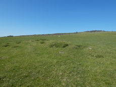
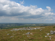
Cox Tor Tor Cairn Stone Ring Cairn Circle
OS Map: SX 53012 76012
HER: MDV50062
ShortName: RC CoxTor 2
Notes: A well preserved Tor cairn approximately 21m in diameter encloses a small, unamed tor 180m SSW of Cox Tor. It comprises a ring of large to medium stones approximately 7m in width which are piled around a natural outcrop. The stones are of a fairly uniform size and most are not earth-fast. To the immediate NE a stretch of low turf-covered rubble walling 1.2m wide, 0.4m high and 15m in length connects two outcrops - it is probably of prehistoric origin but its function is obscure..
Nearby sites: SX 53012 76012
Distance: 0.76km
Langstone Moor S.2 Cairn
OS Map: SX 54838 77646
HER: MDV4116
Megalithic Portal: 35802
ShortName: CN Langston S2
Butler map: 31.19.2
Grinsell: PET 34
Notes: "Two round barrows on Peter Tavy Great Common. (A) SX54847764 A flat topped stony mound, probably a cairn, about 12m E-W by 11m transversely and of 0.6m maximum height. There is no apparent kerb and the edges are ill-defined. It is predominantly turf-covered but a small area of stones is exposed in the NW quadrant presumably the site of the 1899 excavation.(B) SX54887765 Located 45m ENE of 'A' or probable cairn visible as a turf covered mound about 5m in diameter and 0.3m high. No kerb is evident and the centre has been disturbed. The mounds are both quite prominently situated on the summit of a gently domed ridge of rough grassland which is generally devoid of surface stone."
Nearby sites: SX 54838 77646
Distance: 1.69km
White Tor S.S.W.1 Long Cairn
OS Map: SX 54023 78321
HER: MDV4179
ShortName: CN White SSW1
Butler map: 31.21.1
Grinsell: PET 29a
Notes: The Dartmoor Exploration Committee (Report 6 1899) describes investigating 3 cairns in this location. The damaged remains are difficult today to interpret. Many authors suggest that the long cairn consists of two or more of these cairns. The current author visited this location on 27th May 2022 with just the knowledge that there were 3 reported cairns. I photographed a very likely cairn, namely, the long cairn (Butler 1). A semi-circular bank (Butler 3) and a faint mound around a natural rock (Butler 2). I noted at the time of the visit that both 2 and 3 are possible but doubtful cairns. I did not have the Butler account with me at the time I photographed and logged these. Looking now at Butler's account it looks like he reached the same conclusions and the entries here follow Butler with similar doubt on Butler 2 and Butler 3.
Nearby sites: SX 54023 78321
Distance: 1.87km
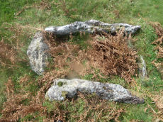
Barn Hill Cist
OS Map: SX 53318 74558
HER: MDV14685
Megalithic Portal: 45785
PMD: Barn Hill
Alternate name: Barn Hill S. Cist
ShortName: CT Barn Hill 1
Butler map: 44.10.3
DPD page: 15
Grinsell: WHI 3
Notes: "The cairn mound measures 5.7 metres in diameter and stands up to 0.2 metres high. The cist lies slightly south of the cairn's centre and survives as a 0.98 metre long by 0.6 metre wide and 0.3 metre deep stone-lined pit".
Barrow Report 39 refers to a posible cist on the northern side of Barn Hill and this is a different feature on the southern side. The Barrow Report refers to MDV4114.
Butler Barn Hill S. - Vol. 3. Map 44.10.3. (diagram p.34). Previously listed with an inaccurate grid reference. Now confirmed at SX 53318 74558.
Nearby sites: SX 53318 74558
Distance: 1.96km
Cox Tor Stone Ring Cairn Circle
OS Map: SX 53060 76190
HER: MDV4151
Megalithic Portal: 32104
Alternate name: Cox Tor Summit Stone Ring Cairn Circle
ShortName: RC CoxTor 3
Butler map: 31.1.3
Grinsell: PET 37a
Turner: A59
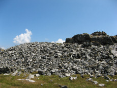
Notes: "Cox tor, ring cairn. The outcrop of granite on the summit is surrounded by an ancient wall, enclosing a space of about 21m in diameter, built of small stones. Pillaged and part used in erection of the cairn for the 1887 jubilee."
NB. The NMR listings had two entries for this feature. The entry SiteID=3229 referred to NMR entry SX 57 NW 132 (Monument Number 919075) which was a duplicate. As the NMR listings are no longer public our entry SiteID=3229 has been deleted.
Nearby sites: SX 53060 76190
Distance: 0.62km

Cox Tor Ancient Pool
OS Map: SX 53635 76205
HER: MDV26281
ShortName: PO Cox Tor
Notes: "Previously recorded from aerial photographs as a possible quarry. Marked as 'pond' on modern mapping and is one of the examples suggested by Greeves (2019) to potentially have Prehistoric origins."
Nearby sites: SX 53635 76205
Distance: 0.30km
Cox Tor (NE) Stone Ring Cairn Circle
OS Map: SX 53047 76430
HER: MDV4127
Megalithic Portal: 32104
Alternate name: Cox Tor N.6 Stone Ring Cairn Circle
ShortName: RC CoxTor 6
Butler map: 31.1.6
Grinsell: PET 36
Turner: A51
Notes: "Narrow ridge of north-south outcropping rock measuring 10 metres in diameter, surrounded by circular stoney bank 4 metres wide, 0.8 metres high. 1890 excavation showed it to consist of an outer bank with central infill of loose stones and earth. No trace of burials or artefacts." "Cox Tor. Smaller of two adjacent cairns. Lies 12.5 metres south-east of larger one (see related record). Similar in shape, though smaller; diameter 8.23 metres. Construction of centre was loose, much earth being mingled with the stone. Nothing found and no pit in the "calm". (Baring-Gould - fifth report of the DEC) Breton p.16 Two very curious ring cairns; one has a diameter of 55ft and the other 27ft.
Nearby sites: SX 53047 76430
Distance: 0.56km
Cox Tor (NW) Stone Ring Cairn Circle
OS Map: SX 53024 76424
HER: MDV4128
Megalithic Portal: 32104
Alternate name: Cox Tor N.5 Stone Ring Cairn Circle
ShortName: RC CoxTor 5
Butler map: 31.1.5
Grinsell: PET 35
Turner: A48
Notes: Breton p.16 Two very curious ring cairns; one has a diameter of 55ft and the other 27ft.
Nearby sites: SX 53024 76424
Distance: 0.58km
Cox Tor N.E. Settlement
OS Map: SX 536 765
HER: MDV4105
Megalithic Portal: 17508
ShortName: ST:CoxTorNE
Notes: Details via Megalithic Portal.
Nearby sites: SX 536 765
Distance: 0.00km
Langstone Moor Stone Ring Cairn Circle
Prehistoric Dartmoor Walks: Dartmoor Site: Langstone Moor Stone Circle, Stone Row & Settlements
OS Map: SX 54843 77922
HER: MDV48862
Megalithic Portal: 45833
ShortName: RC Langstone
Turner: A22
Notes: HER: A semi-circular bank, possibly the remains of a ring cairn.1.4 to 2m wide, 0.4m high. Composed of small + medium sized stones now largely turf-covered. It fades at each end of a near-perfect semi-circle of 14.9m internal diam. There is a low stone pile, 0.2m high, in se quadrant.
Nearby sites: SX 54843 77922
Distance: 1.89km

Roos Tor N.W. Settlement
OS Map: SX 539 772
HER: MDV4104
Megalithic Portal: 17509
ShortName: ST RoosTorNW
Notes: Details via Megalithic Portal. Photo is of round house SiteID=8089
Nearby sites: SX 539 772
Distance: 0.76km
Whitchurch Common (N) Stone Ring Cairn Circle
OS Map: SX 53020 75005
HER: MDV4115
Megalithic Portal: 3535
Alternate name: Whitchurch Common N. Stone Ring Cairn Circle
ShortName: RC Whitchurch1
Turner: A41
Notes: Hut Circle or ring cairn? "Ring cairn with entrance. Stone ring 5.5m internal diam, with bank 1.5m wide and 0.4m high.2.5m wide entrance on ssw side" " A hut with an internal diam of 5.8m and walling 1.5m wide and 0.4m high; there is an entrance gap in the sw. This is evidently grinsell's cairn and worth's barrow.(broadly it is on the n slope of barn hill as stated by worth, but locally on the sw slope). While the structure might in isolation be construed as a cairn, the lack of any internal stone, the consistently smooth angle of the inner face of the wall and the presence of other huts and a field system militate against the worth and grinsell classifications"
Nearby sites: SX 53020 75005
Distance: 1.60km