
Prehistoric sites within 2km of SX 74363 79163
Guidance for walkers: The monuments featured in this database are archaeological treasures and need to be protected and preserved - please do not disturb any sites. Please check access and firing times before visiting sites, not all sites listed are on open access land. Firing ranges and boundaries of open access areas are marked on the OL28 OS Dartmoor Explorer map. Please stick to the country code and consider giving support to the numerous agencies that help to keep Dartmoor a fabulous natural and historic environment!
About the database listings: In all listings clicking on the photo or the site name will open a page for the site with a larger photo and further details from the database. The database now has over 6680 records covering nearly all publicly listed sites on Dartmoor including around 4800 round houses. This level of detail is of interest to archaeologists but tends to swamp listings of sites more likely to be of interest for walkers. For this reason, the listings default to around 550 core sites only. These are the stone circles, stone rows and the ring cairns listed by Turner. The default search radius is 2 km. The controls below the map can be used to start a new search by entering a 6- or 8-digit reference (without the prefix "SX"). The search radius can be specified and you can add incremental Display layers of detail on top of the core sites. If using a more detailed layer you will need to decrease the search radius to avoid getting hundreds of search results.
- Core sites Default listing of core sites consisting of stone circles & rows and some of the major ring cairns.
- Plus cairns adds approx. 1000 cairns and other minor sites not included in the core listings but excluding round houses.
- Plus round houses adds approx. 4800 round houses.
- Plus non-sites adds in the records for sites that no longer exist or are not prehistoric sites.
- Plus duplicates adds records excluded as duplicates. Those maybe duplicate records in external listings (e.g. the Historic Environment Records). For example, some sites have been identified as cairns in some listings and interpreted as round houses in other listings and both records appear.
These listings have incorporated, matched up and merged all of the records from all of the major archaeological listings including: Worth, Grinsell, Turner, Butler, Bill Radcliffe, Sandy Gerrard, Megalithic Portal, the National Monument Records and the Historic Environment Records. The author would like to thank Bill, Sandy, the lovely people both at Megalithic Portal (especially Anne Tate who did an amazing job to link listings) and at ACE Archaeology for collaborative work over the years to synchronise and correct listings across the various websites which now interlink. A culmination of years of work the final merger of cairn records took 3 months of cross referencing in 2017 the result being a snapshot of the records at that time. This data has in turn been refined since by field work and research. The round house data was supplied by Sandy Gerrard. Grid references are in order of accuracy: from Google Earth satellite, if visible and found, from a Garmin GPS reading, if visited by the author and from the literature otherwise. Individual site pages will state the source of the grid reference and provide satellite imagery. If a site listing lacks a photo it has not yet been visited by the author in which case the grid reference is from the literature.
Currently the database only includes sites which can be represented by a grid reference. Reaves are not included as they require GIS shape technology which is beyond the current capability of this system. To see the sources for the records, look at the tables on the resources menu. The database listings can also be viewed on a Google map and downloaded as GPS datasets for Garmin devices.
Corrections, or any feedback or suggestions are very welcome, email: info@dartmoorwalks.org.uk.
NOTE: Clicking on the icons for each monument in the map will give the name of the site. You can zoom in and out and drag the map around.
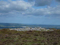
List of sites within 2km of SX 74363 79163
Hayne Down Round House
OS Map: SX 7449 8040
HER: MDV26986
ShortName: HT:Hayne Dow8
Nearby sites: SX 7449 8040
Distance: 1.24km
Hayne Down Round House
OS Map: SX 73973 80583
HER: MDV8815
ShortName: HT:Hayne Dow9
Nearby sites: SX 73973 80583
Distance: 1.47km
Hayne Down Round House
OS Map: SX 74627 80019
HER: MDV26987
ShortName: HT:Hayne Dow10
Nearby sites: SX 74627 80019
Distance: 0.90km
Hayne Down Round House
OS Map: SX 74432 80338
ShortName: HT:Hayne Dow11
Nearby sites: SX 74432 80338
Distance: 1.18km
Chinkwell Tor Cairn
OS Map: SX 7293 7825
HER: MDV20168
ShortName: CN:Chinkwell1
Butler map: 7.3
Grinsell: WID 10
Turner: A63
Nearby sites: SX 7293 7825
Distance: 1.70km
Gratnor Round House
OS Map: SX 7407 7968
HER: MDV7549
ShortName: HT:Gratnor1
Nearby sites: SX 7407 7968
Distance: 0.59km
Great Houndtor Round House
OS Map: SX 74262 79803
HER: MDV7429
ShortName: HT:Great Hou1
Nearby sites: SX 74262 79803
Distance: 0.65km
Great Houndtor Round House
OS Map: SX 74248 79798
HER: MDV7431
ShortName: HT:Great Hou2
Nearby sites: SX 74248 79798
Distance: 0.65km
Great Houndtor Round House
OS Map: SX 74273 79790
HER: MDV7432
ShortName: HT:Great Hou3
Nearby sites: SX 74273 79790
Distance: 0.63km
Hedge Down Round House
OS Map: SX 73109 78576
HER: MDV7518
ShortName: HT:Hedge Dow1
Nearby sites: SX 73109 78576
Distance: 1.38km
Hedge Down Round House
OS Map: SX 73087 78554
HER: MDV7517
ShortName: HT:Hedge Dow2
Nearby sites: SX 73087 78554
Distance: 1.41km
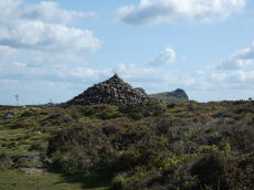
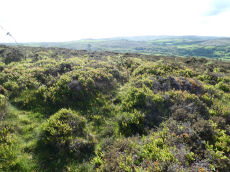
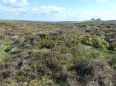
Houndtor Down Round House
OS Map: SX 74375 79154
HER: MDV58418
ShortName: HT:Houndtor 1
Nearby sites: SX 74375 79154
Distance: 0.02km
Houndtor Down Round House
OS Map: SX 74363 79163
HER: MDV58418
ShortName: HT:Houndtor 2
Nearby sites: SX 74363 79163
Distance: 0.00km
Greator Round House
OS Map: SX 74911 78427
HER: MDV7505
ShortName: HT:Greator1
Nearby sites: SX 74911 78427
Distance: 0.92km
Houndtor Down Round House
OS Map: SX 74504 79107
HER: MDV58418
ShortName: HT:Houndtor 3
Nearby sites: SX 74504 79107
Distance: 0.15km
Greator Round House
OS Map: SX 74901 78426
HER: MDV7505
ShortName: HT:Greator2
Nearby sites: SX 74901 78426
Distance: 0.91km
Houndtor Down Round House
OS Map: SX 74391 79155
HER: MDV58418
ShortName: HT:Houndtor 4
Nearby sites: SX 74391 79155
Distance: 0.03km
Greator Round House
OS Map: SX 74824 78394
HER: MDV7505
ShortName: HT:Greator 1
Nearby sites: SX 74824 78394
Distance: 0.90km
Houndtor Down Round House
OS Map: SX 74743 78750
HER: MDV58424
ShortName: HT:Houndtor 5
Nearby sites: SX 74743 78750
Distance: 0.56km
Greator Rocks Round House
OS Map: SX 74686 78550
HER: MDV26802
ShortName: HT:Greator R1
Nearby sites: SX 74686 78550
Distance: 0.69km
Houndtor Down Round House
OS Map: SX 74354 79169
HER: MDV58418
ShortName: HT:Houndtor 6
Nearby sites: SX 74354 79169
Distance: 0.01km
Houndtor Down Round House
OS Map: SX 74469 79148
HER: MDV58423
ShortName: HT:Houndtor 7
Nearby sites: SX 74469 79148
Distance: 0.11km
Houndtor Down Round House
OS Map: SX 74504 79121
HER: MDV58418
ShortName: HT:Houndtor 8
Nearby sites: SX 74504 79121
Distance: 0.15km
Houndtor Down Round House
OS Map: SX 74473 79082
HER: MDV58418
ShortName: HT:Houndtor 9
Nearby sites: SX 74473 79082
Distance: 0.14km
Smallacombe Rocks Round House
OS Map: SX 75663 78292
HER: MDV72895
ShortName: HT:Smallacom1
Nearby sites: SX 75663 78292
Distance: 1.56km
Smallacombe Rocks Round House
OS Map: SX 75695 78172
HER: MDV72898
ShortName: HT:Smallacom2
Nearby sites: SX 75695 78172
Distance: 1.66km
Smallacombe Rocks Round House
OS Map: SX 75716 78268
HER: MDV72896
ShortName: HT:Smallacom3
Nearby sites: SX 75716 78268
Distance: 1.62km
Smallacombe Rocks Round House
OS Map: SX 75654 78244
HER: MDV72897
ShortName: HT:Smallacom4
Nearby sites: SX 75654 78244
Distance: 1.58km
Hayne Down summit Reported Cist
OS Map: SX 744 802
PMD: Hayne Down
ShortName: CT?Hayne Dow1
Butler map: 21.
Grinsell: MAN 3a
Notes: No HER or NMR rcords. Grinsell: LVG and GMS have searched in vain for cist near reave connecting Bowerman's Nose with tor to SE, mentioned by Crossing 1912/1965, 294
Nearby sites: SX 744 802
Distance: 1.04km
Cripdon Down Round House
OS Map: SX 7327 8057
HER: MDV29201
ShortName: HT:Cripdon D1
Nearby sites: SX 7327 8057
Distance: 1.78km
Cripdon Down Round House
OS Map: SX 7345 8031
HER: MDV26683
ShortName: HT:Cripdon D2
Nearby sites: SX 7345 8031
Distance: 1.47km
Cripdon Down Round House
OS Map: SX 73526 80384
HER: MDV26682
ShortName: HT:Cripdon D3
Nearby sites: SX 73526 80384
Distance: 1.48km
Cripdon Down Round House
OS Map: SX 73610 80937
HER: MDV8797
ShortName: HT:Cripdon D4
Nearby sites: SX 73610 80937
Distance: 1.93km
Cripdon Down Round House
OS Map: SX 73583 80959
HER: MDV8762
ShortName: HT:Cripdon D5
Nearby sites: SX 73583 80959
Distance: 1.96km
Blissmoor Round House
OS Map: SX 73659 80705
HER: MDV8802
ShortName: HT:Blissmoor1
Nearby sites: SX 73659 80705
Distance: 1.70km
Blissmoor Round House
OS Map: SX 73680 80756
HER: MDV8763
ShortName: HT:Blissmoor2
Nearby sites: SX 73680 80756
Distance: 1.73km
Chinkwell Tor NE Round House
OS Map: SX 7303 7834
HER: MDV7436
ShortName: HT:Chinkwell1
Nearby sites: SX 7303 7834
Distance: 1.57km
Chinkwell Tor NW Round House
OS Map: SX 72592 78458
HER: MDV7440
ShortName: HT:Chinkwell2
Nearby sites: SX 72592 78458
Distance: 1.91km
Holwell E Round House
OS Map: SX 74849 77489
HER: MDV7402
ShortName: HT:Holwell E3
Nearby sites: SX 74849 77489
Distance: 1.74km
Holwell E Round House
OS Map: SX 74879 77441
HER: MDV7403
ShortName: HT:Holwell E5
Nearby sites: SX 74879 77441
Distance: 1.80km
Holwell E Round House
OS Map: SX 74834 77571
HER: MDV26944
ShortName: HT:Holwell E6
Nearby sites: SX 74834 77571
Distance: 1.66km
Holwell E Round House
OS Map: SX 74851 77526
HER: MDV7401
ShortName: HT:Holwell E7
Nearby sites: SX 74851 77526
Distance: 1.71km
Holwell Lawn Round House
OS Map: SX 7404 7800
HER: MDV7533
ShortName: HT:Holwell L1
Nearby sites: SX 7404 7800
Distance: 1.21km
Holwell Tor Round House
OS Map: SX 753 775
ShortName: HT:Holwell T1
Nearby sites: SX 753 775
Distance: 1.91km
Holwell Tor Round House
OS Map: SX 75399 77609
HER: MDV8091
ShortName: HT:Holwell T2
Nearby sites: SX 75399 77609
Distance: 1.87km
Holwell Tor N Round House
OS Map: SX 75332 77834
HER: MDV8089
ShortName: HT:Holwell T3
Nearby sites: SX 75332 77834
Distance: 1.64km
Black Hill 1 Cairn
OS Map: SX 76213 78605
HER: MDV8044
ShortName: CN BlackHill1
Butler map: 2.5.1
Grinsell: MAN 19
Notes: Butler refers to around twelve cairns at this location, most of which are quite insignificant. The four largest are still well defined and measure approximately 16.5 meters in diameter.
Nearby sites: SX 76213 78605
Distance: 1.93km
Holwell Tor N Round House
OS Map: SX 75284 77805
HER: MDV115871
ShortName: HT:Holwell T4
Nearby sites: SX 75284 77805
Distance: 1.64km
Black Hill 2 Cairn
OS Map: SX 76169 78687
HER: MDV8042
ShortName: CN BlackHill2
Butler map: 2.5.2
Grinsell: MAN 18
Notes: Butler refers to around twelve cairns at this location, most of which are quite insignificant. The four largest are still well defined and measure approximately 16.5 meters in diameter.
Nearby sites: SX 76169 78687
Distance: 1.87km
Holwell Tor N Round House
OS Map: SX 75408 77757
HER: MDV8090
ShortName: HT:Holwell T5
Nearby sites: SX 75408 77757
Distance: 1.75km
Black Hill 3 Cairn
OS Map: SX 76153 78735
HER: MDV8043
ShortName: CN BlackHill3
Butler map: 2.5.3
Grinsell: MAN 17
Notes: Butler refers to around twelve cairns at this location, most of which are quite insignificant. The four largest are still well defined and measure approximately 16.5 meters in diameter.
Nearby sites: SX 76153 78735
Distance: 1.84km
Black Hill 5 Cairn
OS Map: SX 76285 78989
HER: MDV8046
ShortName: CN BlackHill5
Butler map: 2.5.5
Grinsell: MAN 15
Notes: "A cairn at SX76297898 (note slight variation) with a maximum height at the rim of 0.5 meters with a probable retaining stone in the west. The centre of the cairn has been dug out. Other details: Plan."
Nearby sites: SX 76285 78989
Distance: 1.93km
Black Hill 6 Reported Cairn
OS Map: SX 76175 78642
ShortName: CN:BlackHill6
Butler map: 2.5.6
Notes: The HER lists Black Hill 1-5. Butler lists several more, see fig. 2.2 Vol 1 p.28
Nearby sites: SX 76175 78642
Distance: 1.89km
Black Hill 7 Reported Cairn
OS Map: SX 7619 7896
ShortName: CN:BlackHill7
Butler map: 2.5.7
Notes: The HER lists Black Hill 1-5. Butler lists several more, see fig. 2.2 Vol 1 p.28
Nearby sites: SX 7619 7896
Distance: 1.84km
Black Hill 8 Reported Cairn
OS Map: SX 7617 7895
ShortName: CN BlackHill8
Butler map: 2.5.8
Notes: The HER lists Black Hill 1-5. Butler lists several more, see fig. 2.2 Vol 1 p.28
Nearby sites: SX 7617 7895
Distance: 1.82km
Black Hill 9 Reported Cairn
OS Map: SX 7615 7866
ShortName: CN:BlackHill9
Butler map: 2.5.9
Notes: The HER lists Black Hill 1-5. Butler lists several more, see fig. 2.2 Vol 1 p.28. Grid reference is estimated on Google Earth by comparison to Butler's diagram.
Nearby sites: SX 7615 7866
Distance: 1.86km
Black Hill 10 Reported Cairn
OS Map: SX 76102 78655
ShortName: CN BlackHill10
Butler map: 2.5.10
Notes: The HER lists Black Hill 1-5. Butler lists several more, see fig. 2.2 Vol 1 p.28. Grid reference is estimated on Google Earth by comparison to Butler's diagram.
Nearby sites: SX 76102 78655
Distance: 1.81km
Black Hill 11 Reported Cairn
OS Map: SX 76167 78646
HER: MDV26562
ShortName: CN:BlackHill11
Butler map: 2.5.11
Notes: The HER lists Black Hill 1-5. Butler lists several more, see fig. 2.2 Vol 1 p.28. Grid reference is estimated on Google Earth by comparison to Butler's diagram.
Nearby sites: SX 76167 78646
Distance: 1.88km
Black Hill 12 Reported Cairn
OS Map: SX 76167 78676
ShortName: CN:BlackHill12
Butler map: 2.5.12
Notes: The HER lists Black Hill 1-5. Butler lists several more, see fig. 2.2 Vol 1 p.28. Grid reference is estimated on Google Earth by comparison to Butler's diagram.
Nearby sites: SX 76167 78676
Distance: 1.87km
Hayne Down Round House
OS Map: SX 73964 80578
HER: MDV8815
ShortName: HT:Hayne Dow1
Nearby sites: SX 73964 80578
Distance: 1.47km
Hayne Down Round House
OS Map: SX 73998 80606
HER: MDV8815
ShortName: HT:Hayne Dow2
Nearby sites: SX 73998 80606
Distance: 1.49km
Bell Tor Round House
OS Map: SX 73115 77960
ShortName: HT:Bell Tor1
Nearby sites: SX 73115 77960
Distance: 1.73km
Hayne Down Round House
OS Map: SX 74118 79936
ShortName: HT:Hayne Dow3
Nearby sites: SX 74118 79936
Distance: 0.81km
Bell Tor Round House
OS Map: SX 73129 77987
HER: MDV26811
ShortName: HT:Bell Tor2
Nearby sites: SX 73129 77987
Distance: 1.70km
Hayne Down Round House
OS Map: SX 7417 8018
HER: MDV26984
ShortName: HT:Hayne Dow4
Nearby sites: SX 7417 8018
Distance: 1.04km
Bell Tor Round House
OS Map: SX 7320 7805
HER: MDV26808
ShortName: HT:Bell Tor3
Nearby sites: SX 7320 7805
Distance: 1.61km
Hayne Down Round House
OS Map: SX 74209 80138
ShortName: HT:Hayne Dow5
Nearby sites: SX 74209 80138
Distance: 0.99km
Hayne Down Round House
OS Map: SX 7430 8031
HER: MDV26985
ShortName: HT:Hayne Dow6
Nearby sites: SX 7430 8031
Distance: 1.15km
Hayne Down Round House
OS Map: SX 74411 80326
ShortName: HT:Hayne Dow7
Nearby sites: SX 74411 80326
Distance: 1.16km
Black Hill 4 Cairn
OS Map: SX 76281 78963
HER: MDV8045
Megalithic Portal: 26733
ShortName: CN:BlackHill4
Butler map: 2.5.4
Grinsell: MAN 16
Notes: "One of five cairns on Black Hill, all in a damaged condition." "Cairn with modern stoneheap at north end. Diameter 17.0 meters, height 0.7 meters."
Nearby sites: SX 76281 78963
Distance: 1.93km
Black Hill A (Manaton) Ancient Pool
OS Map: SX 76188 78885
HER: MDV127184
ShortName: PO:BlackHillA
Notes: "The pool at Black Hill measures 10-11m. One of over 40 such 'sacred' pools identified on Dartmoor that are thought to have potentially been designed during the prehistoric period."
Nearby sites: SX 76188 78885
Distance: 1.85km
Black Hill B (Manaton) Ancient Pool
OS Map: SX 76171 78465
HER: MDV127185
ShortName: PO:BlackHillB
Notes: "The second pool at Black Hill (B) is interesting as it possesses a double ring bank enclosing a distinct sunken hollow. Externally the feature is about 20 metres in diameter, and the pool hollow about 10 metres. Compared with the King’s Stables pool and earthwork at Navan, County Armagh which is about 25 metres in diameter x 3.5 metres deep, dating to around 1000 BC (although this feature has a shallower form). One of over 40 such 'sacred' pools identified on Dartmoor that are thought to have potentially been designed during the prehistoric period, and may have been used to deposit votive items, although these Dartmoor examples may have alternative significance as designed prehistoric elements in the landscape. Many are located on ridge tops and in conjunction with cairns, stone rows and other prehistoric features. Further research may well reveal more about these interesting features."
Nearby sites: SX 76171 78465
Distance: 1.94km
Bonehill Down Ancient Pool
OS Map: SX 73282 77812
HER: MDV127194
ShortName: PO:BonehillDn
Notes: "The pool on Bonehill Down measures 12 by 6m. One of over 40 such 'sacred' pools identified on Dartmoor that are thought to have potentially been designed during the prehistoric period."
Nearby sites: SX 73282 77812
Distance: 1.73km
Cripdon Ancient Pool
OS Map: SX 73345 80335
HER: MDV127204
ShortName: PO:Cripdon
Notes: "The pool at Cripdon measures 24 by 14m One of over 40 such 'sacred' pools identified on Dartmoor that are thought to have potentially been designed during the prehistoric period"
Nearby sites: SX 73345 80335
Distance: 1.55km
Houndtor Down Ancient Pool
OS Map: SX 74193 78601
HER: MDV127214
ShortName: PO:Houndtor
Notes: "A pool measuring around 50 by 17m. One of over 40 such 'sacred' pools identified on Dartmoor that are thought to have potentially been designed during the prehistoric period. Lies south of a prehistoric cairn."
Nearby sites: SX 74193 78601
Distance: 0.59km
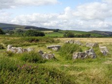
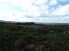
Houndtor Down Ring Setting Cairn and Cist
OS Map: SX 74106 78772
HER: MDV7398
Megalithic Portal: 24187
PMD: Hound Tor
ShortName: CT Houndtor
Butler map: 8.6
Butler Vol 5: p.179 & Fig.121
DPD page: 151
Grinsell: MAN 13
Turner: D8
Barrow Report: 53 56
Notes: "A ring cairn surviving as a mound 6.5 metres in diameter and 0.15 metres high. It is defined, except on the west side, by a ring of at least 19 close set granite stones. In the centre of the cairn is a north to south orientated cist, with both end stones and the western side stone remaining visible.". Butler Vol. 1. Map 8.6 (diagram Vol. 5. p.179).
Nearby sites: SX 74106 78772
Distance: 0.47km
Smallacombe Rocks Settlement
OS Map: SX 757 782
HER: MDV8055
Megalithic Portal: 31843
ShortName: ST:Smallacombe
Nearby sites: SX 757 782
Distance: 1.65km