
Guide to the Monuments on Mardon Down
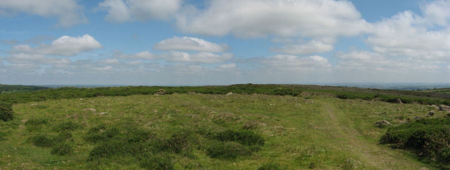
Table of Ritual and Burial Monuments on Mardon Down
Table of Round Houses on Mardon Down
| Guide # | Butler | SiteID | Site Name | OSX | Lat | Lon | NMR | HER | Barrow Report | Photo |
|---|---|---|---|---|---|---|---|---|---|---|
| 7449 | Mardon Down Round House | SX7658087200 | 50.67127991 | -3.74798989 | n/a | MDV26658 | N | |||
| 7450 | Mardon Down Round House | SX7705087400 | 50.67317963 | -3.74141002 | n/a | MDV105980 | N |
Mardon Down Guide Map
Guidance for walkers: The monuments featured in this database are archaeological treasures and need to be protected and preserved - please do not disturb any sites. Please check access and firing times before visiting sites, not all sites listed are on open access land. Firing ranges and boundaries of open access areas are marked on the OL28 OS Dartmoor Explorer map. Please stick to the country code and consider giving support to the numerous agencies that help to keep Dartmoor a fabulous natural and historic environment!
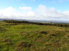
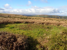
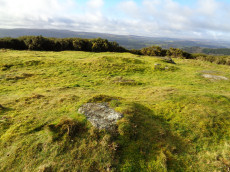
List of Ritual and Burial Monuments on Mardon Down
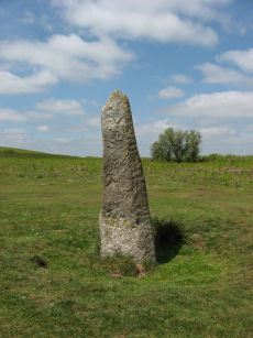
Maximajor Stone Standing Stone
OS Map: SX 77076 87818
NMR record: SX 78 NE 4
HER record: MDV8281
Megalithic Portal: 22324
PMD: Headless Cross Standing Stone
ShortName: SS Maximajor
Notes: Situated on Mardon Moor, the Headless Cross, or Maximajor Stone, despite its name, was never a cross. It was a megalith although apparently the current stone is a replacement for the original which was damaged beyond repair by a car. See also: Legendary Dartmoor: The Maximajor Stone
Nearby sites: SX77088782
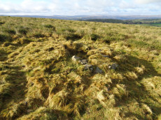
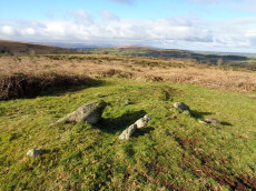
Mardon Down Stone Ring Cairn Circle
OS Map: SX 76729 87264
NMR record: SX 78 NE 19
HER record: MDV19003
Megalithic Portal: 22313
PMD: Mardon Down Cairn 1
Alternate name: Mardon Down Ring Cairn 2 Stone Ring Cairn Circle
ShortName: RC Mardon 2
DPD page: 149
Turner: A36
Notes: "Stone ring with central cairn. Outer ring measures 12.0 metres in diameter with bank 1.5 metres wide and 0.3 metres high. Central cairn 5.0 metres in diameter and 0.4 metres high with disturbance on its western side. Outer ring has 2.5 metre wide entrance on the east."
Nearby sites: SX76738726
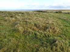
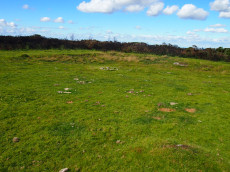
Mardon Down Platform Cairn Circle
OS Map: SX 76759 87172
NMR record: SX 78 NE 19
HER record: MDV15158
Megalithic Portal: 22312
PMD: Mardon Down Cairn 1
Alternate name: Mardon Down Cairn 1 Platform Cairn Circle
ShortName: PC Mardon 1
Butler Vol 5: p.149 & Fig.91
DPD page: 149
Grinsell: MOR 5
Turner: E9
Notes: Platform circle consisting of a ring of kerb stones, measuring 7.0 metres in internal diameter, enclosing a flat-topped cairn 0.3 metres high, with boulder incorporated into perimeter.
Nearby sites: SX76768717
Mardon Down 6 Clearance Cairn
OS Map: SX 76733 87587
NMR record: SX 78 NE 27
HER record: MDV12768
ShortName: CN Mardon 6
Grinsell: MOR 1a
Notes: A small circular mound of stones measuring 4.7 metres in diameter, which is rather small for a sepulchral cairn, and more likely to be associated with clearance, perhaps of a date later than the larger cairns. However, if so, then it is the only recorded example in the vicinity and unusual for that reason. N.B. Extending Butlers 1-5 PDW is numbering this 6.
Nearby sites: SX76738759
Mardon Down 7 Clearance Cairn
OS Map: SX 76761 87477
NMR record: SX 78 NE 6
HER record: MDV20069
ShortName: CN Mardon 7
Grinsell: MOR 2
Notes: "Small dump of cairn material just north of the track, 5 metres in diameter was included in 2017 survey and is thought to be the result of dumping when the main cairn was despoiled, probably in the 19th century." N.B. Extending Butlers 1-5 PDW is numbering this 7.
Nearby sites: SX76768748
Mardon Down (Exc. 18th century) Reported Cairn
OS Map: SX 76800 87500
NMR: No record found
HER record: MDV105916
ShortName: CN?Mardon Do3
Grinsell: MOR 5a
Notes: Linear cairn cemetery aligned broadly north-south on the west side of Mardon Down and comprising some nine cairns. One of the cairns was excavated in the 18th century producing ashes, charcoal and sherds of pottery, although which cairn is uknown.
Nearby sites: SX76808750
Giant's Grave Cairn
OS Map: SX 76768 87459
NMR record: SX 78 NE 6
HER record: MDV8309
Megalithic Portal: 22314
Alternate name: Mardon Down Giant's Grave 4 Cairn
ShortName: CN GiantsGrave
Butler Vol 5: p.147 & Fig.89
DPD page: 149
Grinsell: MOR 3
Notes: Remains of a cairn which was largely destroyed in the early 19th century when material from it was removed for road building. Now a turf-covered mound 20.5 metres diameter and 0.6 metres high.
Nearby sites: SX76778746
Mardon Down S.E. of Giants Grave Cairn Circle
OS Map: SX 76774 87432
NMR record: SX 78 NE 6
HER record: MDV8310
Megalithic Portal: 22315
Alternate name: Mardon Down Cairn 3 Cairn Circle
ShortName: CC Mardon 3
Butler Vol 5: p.147 & Fig.89
Grinsell: MOR 4
Notes: NMR C. Cairn 32.0 metres south-east of Giant's Grave. 11.0 metres diameter, 0.7 metres high with traces of a retaining circle on the south-west side.
Nearby sites: SX76778743
Mardon Down 9 Reported Cairn
OS Map: SX 76760 87380
NMR: No record found
HER record: MDV105915
ShortName: CN?Mardon Do4
Notes: Cairn visible on LiDAR survey on west side of footpath, 40 metres north of the dewpond. Could not be located during a site visit in 2015. N.B. Extending Butlers 1-5, PDW is numbering this 9.
Nearby sites: SX76768738
Mardon Down (NE of Headless Cross) Cairn
OS Map: SX 77463 87921
NMR: No record found
HER record: MDV20073
ShortName: CN Mardon NE2
Notes: The source of this record is the HER which gives a location of SX 77500 87928. From Google Earth this would place this site deep in bracken cover. Around 40 m due West there is a clerigthat looks plausibly like a cairn from Google Earth. This is just a few meters north of the possible cist. PDW is assuming the HER record is referring to this location i.e. SX 77463 87921. Also it seems likely that HER record 20073 refers to the same site despite different NGRs - it is little to the north - so possible duplicate entries.
UPDATE 31/12/2022. This record is now linked to MDV20073, record MDV105931 has been deleted.
Nearby sites: SX77468792
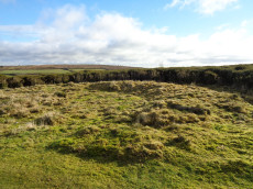
Blackpool (Mardon) Ancient Pool
OS Map: SX 76757 87350
NMR: No record found
HER record: MDV19004
ShortName: PO Blackpool
Notes: "Marked as an enclosure on historic mapping, this is actually a seasonal pond. Surveyed in 2017, its outline shape is unevenly rounded on the western end. Its appearance, with small scarped edges, suggest it was hand dug and large boulders around the edge have been left in situ. The hollow measures 22 metres by 17 metres but is only 0.5 metres deep. An alignment of small stones in the base of the hollow may be a more recent addition. There is no indication as to where material removed from the hollow was dumped. Cannot be confirmed for certain as a dewpond and no evidence was found for this ever having been the site of a ring cairn, as previously suggested. Recorded as Black Pool in 1912. Included in Greeves' list (2019) of 'sacred pools', with potentially prehistoric origins."
Nearby sites: SX76768735
Mardon Down 8 Reported Cairn
OS Map: SX 76730 87238
NMR: No record found
HER record: MDV15159
ShortName: CN Mardon 8
Notes: Newman (2017) "This earthwork, which sits 18m north of the stone circle, has in the past been recorded as a cairn. However, there has to be some uncertainty over this because, apart from its location (on a hilltop and associated with other prehistoric monuments), the layout of the surviving earthworks make it very difficult to interpret precisely. The earthworks appear random but vestiges of what might have been a bank forming part of a perimeter runs around the northeast and west sides, although this is breached on the northern corner and cannot be traced along the southern side. The central area of the feature is slightly raised and embanked in places, with a natural granite outcrop on its western corner, which appears undisturbed. Some additional detached slabs of stone appear to be naturally placed moorstone and probably do not form part of a monument. The total spread of the earthworks is 24m at the broadest point, and the central mound is 0.4m high. It is possible therefore that an inner mound or platform, which incorporated a natural outcrop, has become disturbed and misshapen, but was once surrounded by an outer bank, thus perhaps representing the earthworks of a sepulchral monument. However, insufficient evidence survives in an intact state to be certain.". N.B. Extending Butlers 1-5 PDW is numbering this 8.
Nearby sites: SX76738724
Mardon Down (NE of Headless Cross) Reported Cist
OS Map: SX 77470 87904
NMR record: SX 78 NE 35
HER record: MDV20076
PMD: Mardon Down
ShortName: CT Mardon NE1
Notes: The possible remains of a kerbed cairn with a cist. It comprises a disturbed mound of sub-rectangular form 8.0 by 7.0 by 0.6 metres high. There are three stone slabs set in a mound around a hollow 0.4 metres deep. To the northern edge 3 or 4 stones set on edge give the impression of a kerb. The HER gives the location as SX 77462 87956 - but imagery on Google Earth tends to suggest this is inaccurate.
Nearby sites: SX77478790
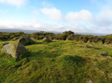
Mardon Down Embanked Cairn Circle
OS Map: SX 76744 87691
NMR record: SX 78 NE 5
HER record: MDV8308
Megalithic Portal: 3375
Alternate name: Mardon Down Pillared Circle 5 Embanked Cairn Circle
ShortName: CC Mardon 5
Butler Vol 5: p.150 & Fig.92
DPD page: 149
Grinsell: MOR 1
Turner: B6
Notes: Impressive cairn circle with a well preserved ring of large pillars surrounded by an outer kerb ring of smaller slabs on their edges. The cairn is 11m. in diameter and 0.5m. high, with a well preserved cairn circle comprising a 9.0m. diameter circle of spaced uprights averaging 0.8m. high, with kerbing between. Unlike the stone circle it is marked on the OS Okehampton and North Dartmoor Landranger map (Sheet 191). It is easy to confuse this cairn with the less well preserved stone circle which is a few hundred metres to the south. Turner B6.
Nearby sites: SX76748769

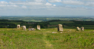
Mardon Down Stone Circle
OS Map: SX 76764 87203
NMR record: SX 78 NE 19
HER record: MDV8289
Megalithic Portal: 3376
PMD: Mardon Down Stone Circle
ShortName: SC Mardon Down
Butler Vol 5: p.148 & Fig.90
DPD page: 149
Turner: G1
Notes: Mardon Down stone circle is the biggest by circumference on Dartmoor with a diameter of 38m. The site would have been impressive in its day and is one of the only ones sited on the top of high ground and has a fine view of the surrounding area. Today the circle is fairly dilapidated. Six stones remain upright and another 16 lie roughly in place. There are two massive megaliths one of which is on the north-western part of the circle. A short arc of seven stones remains in position on the south-east of the circle. The circle was first described by Dr Milles in 1772 who reported around 70 stones. Butler suggests it probably originally consisted of around 61 stones many of which are probably buried under the peat where they originally fell although some have no doubt been robbed out.
Nearby sites: SX76768720
Mardon Down (E) Stone Ring Cairn Circle
OS Map: SX 76894 87602
NMR record: SX 78 NE 21
HER record: MDV12771
Megalithic Portal: 45824
ShortName: RC Mardon East
Butler Vol 5: p.147 & Fig.89
DPD page: 149
Turner: A10
Notes: "Circular earthwork, possibly a ring cairn, the north-west corner of which has been destroyed where it abuts a footpath. Internal diameter 13.3 metres with a bank 2.5 metres wide and 0.6 metres high."
Nearby sites: SX76898760
Page last updated 28/05/23