
Guide to the Monuments on Yes Tor
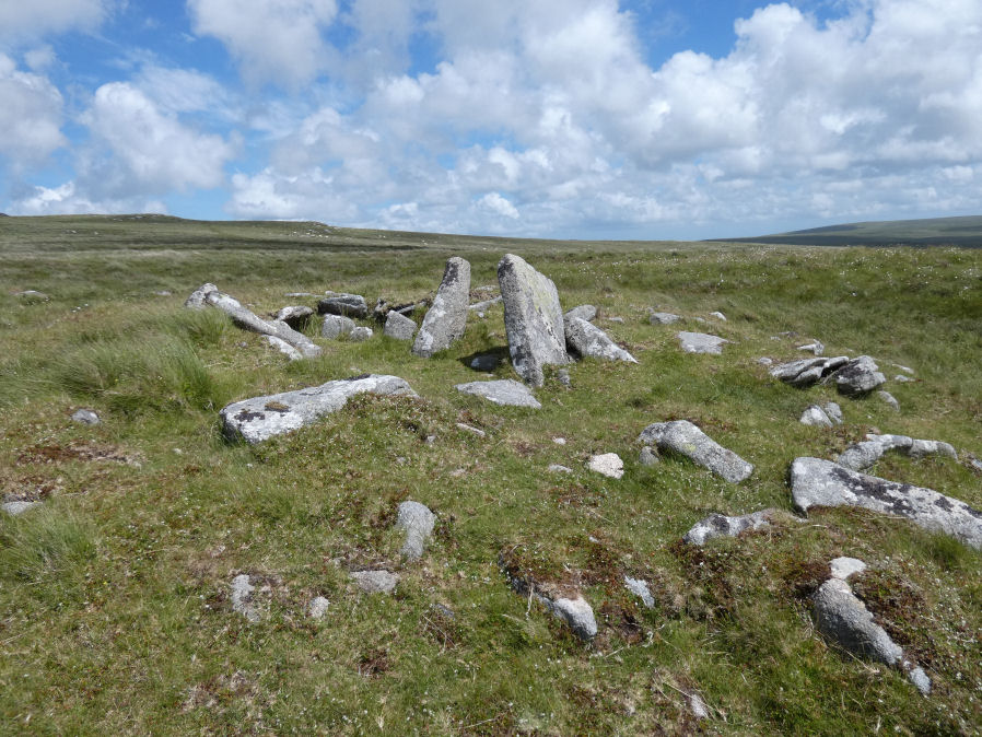
Table of Ritual and Burial Monuments on Yes Tor
The following table lists the records currently in this Guide Map. For an explantion of the Guide Maps and a table of all 62 Guide Maps, follow this link: Guide List Table. Introductory text will be added to each guide list in 2025. Notes on duplication and omissions will appear below the table once checks have been finalised.
Notes on possible duplications and omissions
High Willhayes Crossing Cairn: This has been logged here as a probable duplicate. However, it requires a field visit to clarify whether or not this is in fact the case. This note is to remind the author to check this out.PS. These notes are to assist untangling complicated records and are neither permanent nor a criticism of the HER who do a fantastic job! The author finds it easier to systematically work through these records (2000+ of them) and add these notes, which are then to be communicated with the HER, if appropriate, it is a pragmatic way of dealing with lots of data without continually stopping and starting.
Yes Tor Guide Map
Guidance for walkers: The monuments featured in this database are archaeological treasures and need to be protected and preserved - please do not disturb any sites. Please check access and firing times before visiting sites, not all sites listed are on open access land. Firing ranges and boundaries of open access areas are marked on the OL28 OS Dartmoor Explorer map. Please stick to the country code and consider giving support to the numerous agencies that help to keep Dartmoor a fabulous natural and historic environment!
List of Ritual and Burial Monuments on Yes Tor
Fordsland Ledge Chambered Cairn
OS Map: SX 57581 88897
HER record: MDV3169
Megalithic Portal: 36418
PMD: Fordsland Ledge
ShortName: CN Fordsland
Butler map: 42.3
Butler Vol 5: p.160 & Fig.98
Grinsell: OKE 4
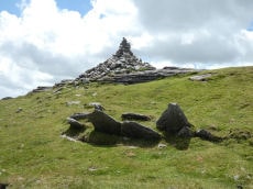
Notes: " In a crest position on Fordsland Ledge at 581.0m OD is the disturbed remains of a turf-and-heather-covered cairn. It measures 12.2m by 13.9m in diameter and is 1.1m high. In a hollow in the centre are a number of large stones suggesting the possibility of a former cist or even a chamber, utilizing the natural outcrop as its base." "The large stones visible in the centre of the feature are somewhat unusual and not typical of a cist-like structure. The presence of a chamber is very doubtful and it is more likely that the interior of the cairn has, at some point, been remodelled to create a small shelter."
Nearby sites: SX57588890
High Willhays Stone Ring Cairn Circle
OS Map: SX 58032 89224
HER record: MDV21296
Megalithic Portal: 36417
ShortName: RC HighWill
Butler map: 42.2
Turner: A65
Notes: "Higher willhayes ring cairn. Irregular segment of stone ring set against rock outcrop.10m wide n-s and 5.5m radius to outcrop, with bank 1m wide and 0.2m high. Also contains segment of stone setting 7.5m wide n-s, 2.5m radius to outcrop"
Nearby sites: SX58038922
High Willhays (N) Stone Ring Cairn Circle
OS Map: SX 58020 89440
HER record: MDV20152
Megalithic Portal: 45849
ShortName: RC:HighWill N
Grinsell: OKE 5
Turner: A64
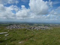
Notes: "A revetted mound adjoins the south side of one of the granite outcrops at High Willhays. Measuring 19 metres east to west by 18 metres overall it stands around 0.8 metres high. The sides of the mound are formed by coursed granite slabs and boulders and the top is largely flat though a hollow has formed in the southern half."
Nearby sites: SX58028944
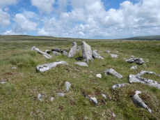
High Willhays Clearance Cairn
OS Map: SX 58020 89210
HER record: MDV28576
ShortName: CN-HighWill 1
Grinsell: B:OKE 5b
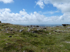
Notes: Modern stone-heap on outcrop. In the photo the modern heap can be seen as can High Willhays Stone Ring Cairn Circle SiteID=565 in the foreground.
Nearby sites: SX58028921
High Willhays (Crossing) Reported Cairn
OS Map: SX 58000 89700
HER record: MDV20153
ShortName: CN?HighWill 2
Grinsell: OKE 5a
Notes: Very likely same as Oke 5. Account from Crossing 1905
Nearby sites: SX58008970
Yes Tor W Cairn
OS Map: SX 57955 90210
HER record: MDV4813
Megalithic Portal: 36416
Alternate name: Yes Tor 1 Cairn
ShortName: CN Yes Tor W
Butler map: 42.1.1
Grinsell: OKE 1
Notes: Western of two round barrows on the summit of yes tor. About 36.6m nw of flag staff on the top of yes tor is an incomplete ring of rough granite boulders varying in size but generally 0.3m - 0.9m. Long. The ring is about 6.1m long and is defective on the north east side where there is evidence of a slightly sunken trackway. In the interior of this ring the ground is slightly irregular and contains blocks of granite. At the south western part of the circle a smaller circle of stones abuts on the previous circle. Butler Volume 2 Map 42.1.
Nearby sites: SX57969021
Yes Tor E Cairn
OS Map: SX 58044 90185
HER record: MDV4814
Megalithic Portal: 36416
Alternate name: Yes Tor 2 Cairn
ShortName: CN Yes Tor E
Butler map: 42.1.2
Grinsell: OKE 2
Notes: One of two cairns on Yes Tor. On the top of the flat outcrop of Yes Tor and piled against the west side is an amorphous mass of stones representing a ruined cairn. The patch of stones on the top is more or less 14.0m across and 0.3 m high and the piling against the outcrop is 2.3m high. It is possible that this has resulted from bulldozing the cairn over the side of the outcrop but the stones appear quite stable and compacted.
Nearby sites: SX58049019
Yes Tor N.W. Cairnfield Master
OS Map: SX 57230 91000
HER record: MDV134416
ShortName: CN?YesTorN M
Butler map: 42.7.1
Notes: Master record for 3 clearance cairns, see individual records. This record marked as a duplicate as a master record.
Nearby sites: SX57239100
Yes Tor N.W.1 Clearance Cairn
OS Map: SX 57230 91000
HER record: MDV134416
ShortName: CN?YesTorN 1
Butler map: 42.7.1
Notes: Clearance cairn
Nearby sites: SX57239100
Yes Tor N.W.2 Clearance Cairn
OS Map: SX 57240 91020
HER record: MDV134416
ShortName: CN?YesTorN 2
Butler map: 42.7.2
Notes: Clearance cairn
Nearby sites: SX57249102
Yes Tor N.W.3 Clearance Cairn
OS Map: SX 57280 91000
HER record: MDV134416
ShortName: CN?YesTorN 3
Butler map: 42.7.3
Notes: Clearance cairn
Nearby sites: SX57289100
West Mill Tor Reported Stone Row
OS Map: SX 58780 90780
HER record: MDV11812
ShortName: SR:West Mill
Notes: HER: A double stone row thought to be of prehistoric date comprises 35 surviving stones, of which 7 are recumbent. The original arrangement may have included 64 stones. They now stand at a distance of 9m between rows as slabs set on edge and in line averaging 0.15m thick, 0.5m long and 0.4m high. A sinuous double row of set stones lies across the summit area of a moorland ridge. Its origins and function are obscure but it may be associated with military activity, possibly a trackway.
Nearby sites: SX58789078
West Mill Tor Reported Cairn
OS Map: SX 58980 90600
HER record: MDV103614
ShortName: CN:West Mill
Notes: HER: Two small cairns at SX 58989060 and SX 58989059 and a short length of a low, spread boulder/stone bank indicate stone clearance activity. Whether the amorphous bank was intended to be the start of a newtake bank is not clear. (It extends from SX58959059 to SX 59069059).
Nearby sites: SX58989060

East Mill Tor Reported Cairn
OS Map: SX 59953 89302
HER record: MDV12849
ShortName: CN:East Mill
Notes: HER: There is no ground evidence to suggest the presence of the cairn described by source (1). However, a stoney mound 0.6m high lies at SX 59948928 and forms part of the retaining bank of a small tinners' reservoir (SX 58 NE 29). If taken in isolation this feature may be confused with a prehistoric cairn.
Prowse: A small tumulus a short distance south of East Miltor (East Mill Tor) and due east of High Willis (High Willhays).
Nearby sites: SX59958930
Page last updated 10/12/24