
Guide to the Monuments on Wigford Down
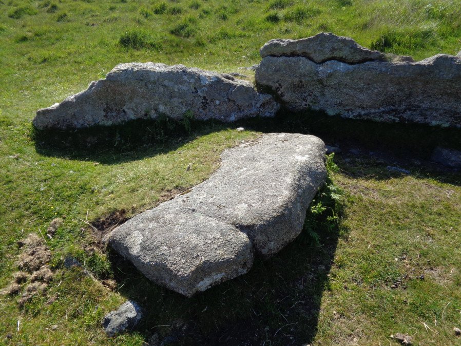
Table of Ritual and Burial Monuments on Wigford Down
The following table lists the records currently in this Guide Map. For an explantion of the Guide Maps and a table of all 62 Guide Maps, follow this link: Guide List Table. Introductory text will be added to each guide list in 2025. Notes on duplication and omissions will appear below the table once checks have been finalised.
Notes on possible duplications and omissions
NB. Wigford Down cairns 12-14 see also Guide to the Monuments on Trowlesworthy Warren
PS. These notes are to assist untangling complicated records and are neither permanent nor a criticism of the HER who do a fantastic job! The author finds it easier to systematically work through these records (2000+ of them) and add these notes, which are then to be communicated with the HER, if appropriate, it is a pragmatic way of dealing with lots of data without continually stopping and starting.
Wigford Down Guide Map
Guidance for walkers: The monuments featured in this database are archaeological treasures and need to be protected and preserved - please do not disturb any sites. Please check access and firing times before visiting sites, not all sites listed are on open access land. Firing ranges and boundaries of open access areas are marked on the OL28 OS Dartmoor Explorer map. Please stick to the country code and consider giving support to the numerous agencies that help to keep Dartmoor a fabulous natural and historic environment!
List of Ritual and Burial Monuments on Wigford Down
Dewerstone Neolithic Enclosure
OS Map: SX 53800 63900
HER record: MDV2380
Megalithic Portal: 29453
ShortName: NE:Dewerstone
Butler map: 48.1
Notes: A poorly preserved stone-built double walled enclosure, the outer of which is thought to represent the site of a Neolithic hilltop enclosure. "The outer enclosure is potentially Neolithic, while the inner is probably of Bronze Age date. The stone-built double wall of the outer enclosure is poorly preserved with an average height of 0.7m, and given its loose composition is unlikely to have stood higher than 1.5m. The inner and outer walls now have average widths of 4.0m and 3.4m respectively. Five probable or possible entrances through the double wall were identified; the existence of so many may support the hypothesis that the enclosure is of Neolithic date." See also Dartmoor Tor Enclosures Project.
Nearby sites: SX53806390
Dewerstone Fort
OS Map: SX 53872 64000
HER record: MDV2381
Megalithic Portal: 29453
ShortName: FT:Dewerstone
Notes: HER: A bank defined rectangular enclosure of probable Bronze Age date has been recorded by field and aerial survey on the north-west edge of the summit of Dewerstone Rock. A hut circle is incorporated into the enclosure’s north-west corner. The enclosure is situated within the boundary of an earlier, probably Neolithic enclosure. See also Dewerstone Neolithic Enclosure
Nearby sites: SX53876400
Dewerstone Hill Enclosed Settlement
OS Map: SX 53940 64084
HER record: MDV63617
Megalithic Portal: 29453
ShortName: ES:Dewerstone
Notes: "stone hut circle forming part of an enclosed settlement on the summit of dewerstone hill "
Nearby sites: SX53946408
Knowle Wood Fort
OS Map: SX 53356 64126
HER record: MDV125834
ShortName: FT:Knowle Wood
Notes: "A possible bank or scarp is identifiable as an earthwork on visualisations derived from lidar data captured between 1998 and 2017, forming a near-complete circuit around the summit of the hill under Knowle Wood, Bickleigh. The earthworks are tentatively interpreted as evidence of a tor enclosure of Neolithic date or a hillfort or of Iron Age origin. The earthwork varies in width from circa 4 to 6m wide and is visible traversing the north-west, south-west and south-east sides of the hill for circa 330m, enclosing an area of just over 1ha. The bank or scarp closely follows the 140m contour on the north-west side of the hill. To the south-west it crests the hill dropping to the 135m contour, before turning to the north-east and dropping further to an elevation of circa 125m.
Nearby sites: SX53366413
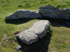
Wigford Down Platform Cairn Circle and Cist
OS Map: SX 54419 64427
HER record: MDV2373
Megalithic Portal: 3536
PMD: Wigford Down S.
Alternate name: Wigford Down 1 Platform Cairn Circle and Cist
ShortName: CT:Wigford 1
Butler map: 48.1.1
DPD page: 33
Grinsell: MEA 7
Turner: E6
Barrow Report: 12 19
Notes: "A badly disturbed prehistoric cist with displaced cover stone and vestiges of a retaining circle surviving in situ. Only five slabs of the retaining circle survive approximately upright in situ, suggesting the overall diameter of the complete circle was 8.35m. The long slabs of the central cist are also in situ and the chamber measures 1.1m by 0.28m approximately by 0.3m deep. A large, flat, intact cover stone of 1.4m by 1.17m, with a rounded end, is displaced to the south. Some material from the turf covered cairn is still visible, but much disturbed and depleted." Butler Wigford Down 1 - Vol. 3. Map 48.1 (diagram p.80).
Nearby sites: SX54426443
Wigford Down 2 Cairn
OS Map: SX 54675 65110
HER record: MDV2312
ShortName: CN Wigford 2
Butler map: 48.1.2
Grinsell: MEA 2
Barrow Report: 62
Notes: The remains of a disturbed prehistoric cairn. It was re-used as an observation post during World War Two. Wigford Down 1 in Barrow Report 62.
Nearby sites: SX54686511
Wigford Down 3 Reported Cairn
OS Map: SX 54647 65072
HER record: MDV2311
ShortName: CN:Wigford 3
Butler map: 48.1.3
Grinsell: MEA 3
Barrow Report: 21 62
Notes: Appears in Tom Greeve's list of 'sacred Pools' as Wigford Down A.
Possible ring cairn on Wigford Down damaged by stone robbing; probably for nearby road-building. Consists of a large oval depression, surrounded by a stony ring with some slabs in upright positions. Wigford Down 2 in Barrow Report 62.
Thought originally to be a damaged ring cairn, the feature consists of a large oval depression, surrounded by a stony ring with some slabs in upright positions. Feature is thought to potentially be a 'sacred' pool designed in Prehistoric times.
Nearby sites: SX54656507
Wigford Down 4 Embanked Cairn Circle
OS Map: SX 54694 64972
HER record: MDV2368
Megalithic Portal: 3536
ShortName: CC Wigford 4
Butler map: 48.1.4
Grinsell: MEA 7a
Turner: A39
Barrow Report: 12 62
Notes: Listed as Wigford Down B on Tom Greeves list of potential 'Sacred' Pools.
NMR B. "Stone ring, diam 10.5m, with bank 2.5m wide and 0.5m high.3m wide entrance on s side" See Butler Vol 3 p.97 fig. 48.1.2. Wigford Down 3 in Barrow Report 62.
This ring cairn survives as a circular bank measuring up to 3.5 metres wide and 0.75 metres high which surrounds a flat interior up to 17.5 metres in diameter. There is evidence for partial early excavation or robbing on the south west side. Noted in 2019 as a possible 'sacred' pool.
Nearby sites: SX54696497
Wigford Down (S) Stone Ring Cairn Circle
OS Map: SX 54702 64962
HER record: MDV2367
Megalithic Portal: 3536
PMD: Wigford Down Summit
Alternate name: Wigford Down 5 Stone Ring Cairn Circle
ShortName: RC Wigford 5
Butler map: 48.1.5
Grinsell: MEA 7b
Turner: B9
Barrow Report: 62
Notes: "One of two cairn circles, both in a raised platform. Ring of large stones. Cist cover in centre. Diam 7.62m.". This site could also be a hut circle - it is unclear whether the large slab is a cist cover or not. See Butler Vol 3 p.97 fig. 48.1.2 Wigford Down 4 in Barrow Report 62. NMR A.
Nearby sites: SX54706496
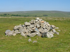
Wigford Down 6 Cairn
OS Map: SX 54958 65088
HER record: MDV2310
ShortName: CN:Wigford 6
Butler map: 48.1.6
Grinsell: MEA 4
Notes: HER: One of two cairns in a group on Wigford Down; these are contained within the coaxial field system. This is a round cairn which survives as a circular mound measuring 10 metres in diameter and 0.6 metres high. A ring cairn lies just to the south (MDV48903), while three other cairns lie to the south-east.
Nearby sites: SX54966509
Wigford Down 7 Reported Cairn
OS Map: SX 54950 65070
HER record: MDV48903
PMD: Wigford Down 7
ShortName: CN?Wigford 7
Butler map: 48.1.7
Grinsell: MEA 4a
Turner: A42
Notes: Grinsell states maybe hut circle. Possible hut circle adjacent to a cairn near to a reave on Wigford Down. This is scheduled as a cairn, but seems more likely to have been a hut. Three more cairns lie to the south-east which are all scheduled.
Nearby sites: SX54956507
Wigford Down 8 Reported Cairn
OS Map: SX 54670 65080
HER record: MDV2313
ShortName: CN:Wigford 8
Butler map: 48.1.8
Notes: HER: One of a group of four cairns or remains of cairns on or near the summit of Wigford Down. This cairn lies to the immediate south-east of a large damaged summit cairn (MDV2312) and measures 5.0 metres by 0.2 metres.
Nearby sites: SX54676508
Wigford Down Stone Ring Cairn Circle
OS Map: SX 54690 65050
HER record: MDV48904
Megalithic Portal: 3536
Alternate name: Wigford Down 9 Stone Ring Cairn Circle
ShortName: RC:Wigford 9
Butler map: 48.1.9
Grinsell: MEA 3a
Turner: A31
Notes: "Ring cairn, wigford down. Internal diam 2.7m, with bank 1m wide and 0.2m high. Smallest ring cairn (diam) on dartmoor. Turner suggests a link between the construction of this, small, ring cairn, with the larger cairn sx56nw/11 to its nw."
Nearby sites: SX54696505
Wigford Down 10 Cairn
OS Map: SX 55021 65032
HER record: MDV5619
ShortName: CN:Wigford10
Butler map: 48.1.10
Grinsell: MEA 5
Barrow Report: 62
Notes: Wigford Down 5 in Barrow Report 62.
Nearby sites: SX55026503
Wigford Down 11 Cairn
OS Map: SX 55060 65021
HER record: MDV12718
ShortName: CN:Wigford11
Butler map: 48.1.11
Grinsell: MEA 6
Notes: HER: One of three scheduled round cairns that lie outside the coaxial field system on Wigford Down and survive as circular mounds. This cairn measures 7.0 metres in diameter by 0.3 metres in height. All three show evidence for either partial early excavation or robbing.
Nearby sites: SX55066502
Wigford Down Cairn Circle
OS Map: SX 54172 65243
HER record: MDV2300
Alternate name: Wigford Down 12 Cairn Circle
ShortName: CN Wigford12
Grinsell: MEA 2a
Notes: Retaining circle on nw slope of wigford down a little way to north of a green track which leads from the salient point of the enclosure wall between Urgles and Higher Bellever to the high road near durance.183m away lies a pound with two hut circles associated. Southern circumference of circle has been robbed and stones of cairn removed. The stones of the circle are small, only one exceeding 1.22m
Nearby sites: SX54176524
Wigford Down (site of) 13 Reported Cairn
OS Map: SX 54380 64430
HER: No record found
PMD: Wigford Down
ShortName: CT?Wigford13
Notes: Radcliffe quotes Barrow Report 12: "Near by, to the north [of Wigford Down S, 5442 6442], stand two more circles, in one of which are what may be the remains of another kistvaen." Not found near the above grid reference. This probably refers to the cairns on the summit, at 5471 6494. [Probably a duplicate]
Nearby sites: SX54386443
Wigford Down A Ancient Pool
OS Map: SX 54650 65078
HER record: MDV2311
ShortName: PO:WigfordA
Notes: This is a duplicate of SiteID=1464 and as such is marked as a duplicate. See Wigford Down 3 Reported Cairn
Nearby sites: SX54656508
Wigford Down B Ancient Pool
OS Map: SX 54694 64972
HER record: MDV2368
Megalithic Portal: 3536
ShortName: PO WigfordB
Barrow Report: 12 62
Notes: This is a duplicate of SiteID=235 and as such is marked as a duplicate. See Wigford Down 4 Embanked Cairn Circle
Nearby sites: SX54696497
Wigford Down C Ancient Pool
OS Map: SX 54733 64981
HER record: MDV127231
ShortName: PO:WigfordC
Notes: "A pool measuring 22 by 17.5m. One of over 40 such 'sacred' pools identified on Dartmoor that are thought to have potentially been designed during the prehistoric period. Lies near two cairns"
Nearby sites: SX54736498
Lower Cadworthy farm Clearance Cairn
OS Map: SX 54400 64300
HER record: MDV119020
ShortName: CN:Cadworthy1
Notes: HER: Clearance cairn on western side of field associated with Lower Cadworthy farm. Cairn or stone dump 5 metres by 7 metres by up to 1.2 metres high about 15 metres inside an old gateway in the cornditch. There is a kink in the cornditch at this point with another mound or cairn next to the gateway.
Nearby sites: SX54406430
Lower Cadworthy Farm Clearance Cairn
OS Map: SX 54400 64300
HER record: MDV119021
ShortName: CN:Cadworthy2
Notes: HER: Clearance cairn in south-west corner of field associated with Lower Cadworthy Farm. Cairn adjacent to field bank about 6 metres diameter and up to 1.2 metres high. There are three other possible cairns or stone dumps on natural outcrops forming a rough line to the east
Nearby sites: SX54406430
Cadworthy Farm Clearance Cairn
OS Map: SX 54400 64300
HER record: MDV119022
ShortName: CN:Cadworthy3
Notes: HER: At least five cairns in the western half of a field associated with Cadworthy Farm. The largest is 7 metres long by 4 metres wide and 1 metre high and aligned east to west. The others are smaller and based on natural outcrops.
Nearby sites: SX54406430
Wigford Down Clearance Cairn
OS Map: SX 54400 64400
HER record: MDV128075
ShortName: CN:Wigford15
Notes: HER: A concentration of over 50 clearance heaps, spread over an area of approximately 3.6 hectares in an area of much prehistoric activity at the southern end of Wigford Down. The clearance cairns comprise mounds of stones, usually partly or fully covered by turf and heather, that were piled at random intervals within the areas being cleared. Most are approximately circular with a diameter between 1m and 9m with an average of 4m standing up to 0.5m high.
Nearby sites: SX54406440
Wigford Down Cairn Circle
OS Map: SX 54220 64450
HER record: MDV5617
ShortName: CN:Wigford16
Notes: HER: A circular structure, previously recorded as a hut circle, this circle is large and regular and appears to have been constructed from small stones, now evenly covered by turf, and although sited on slightly sloping ground, no effort was made to level the interior. One partly exposed section shows that some of the stones were laid in courses and that the walls contain no orthostats. The external diameter is a consistent 14.4m, with a measurable internal diameter of 8.8m and the bank does not appear to be spread, standing to a height of only 0.4m. A 1.7m-wide opening cuts through the western arc of the wall, but no door jambs are present, standing or fallen. The construction method of the circle and state of survival is comparable to ring cairns elsewhere on Dartmoor, which would offer a more likely interpretation for this asset. Although a further, alternative explanation for such a regular well-preserved circular structure could be that it was a more recent military asset
Nearby sites: SX54226445
Page last updated 10/12/24