
Guide to the Monuments on Bellever and Dunnabridge
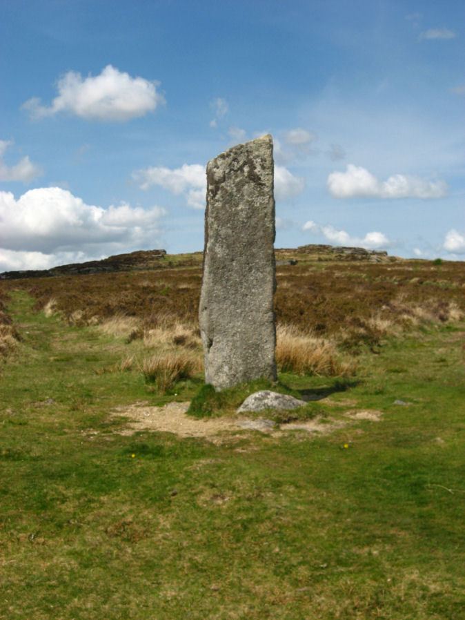
Table of Ritual and Burial Monuments on Bellever and Dunnabridge
The following table lists the records currently in this Guide Map. For an explantion of the Guide Maps and a table of all 62 Guide Maps, follow this link: Guide List Table. Introductory text will be added to each guide list in 2025. Notes on duplication and omissions will appear below the table once checks have been finalised.
Notes on possible duplications and omissions
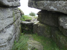
Bellever Tor 5: This record used to link to HER record MDV 5889 but that is clearly Bellever Tor 4 (ring cairn). This site is mentioned within that HER entry but it is a separate monument. Arguably it needs its own record. See also: Dartmoor Explorations: Antiquities of Black Newtake and EnvironsLower Cherrybrook Bridge Round House: What is this feature? Does it warrant an HER entry? The HER entries in this location refer to quarrying but this is not a quarry. It looks a little like a buddle but I am unable to identify what it is. The consensus on one Facebook forum is that it is probably a round house that has been repurposed in the historic period as a shepherds shelter. See also: Dartefacts: Lower Cherrybrook Bridge Round House
Riddon Ridge Cairns: The sites Riddon Ridge S.E. (Butler, Grinsell LYDFORD 67a) and Riddon Ridge (E Slope) (Grinsell LYDFORD 67ai) both have the same HER entry of MDV129868. This entry seems more appropriate for LYDFORD 67ai but has components of LYDFORD 67a mixed in, namely, references to the excavated cairn by Burnard described in Barrow Report 33 combined with the alleged cairn that could not be located. The record for the RHR stone, a third cairn, is also confused with the barrow report cairn Riddon Ridge S. (MDV5986). It maybe that fieldwork is required to untangle these records but to the current author there appear to be 3 very different cairns involved her with only 2 HER entries. The actual Barrow report cairn being a different feature without it's own entry.
NB. For northern Riddon Ridge cairns, see: Guide to the Monuments on Lakehead Hill
PS. These notes are to assist untangling complicated records and are neither permanent nor a criticism of the HER who do a fantastic job! The author finds it easier to systematically work through these records (2000+ of them) and add these notes, which are then to be communicated with the HER, if appropriate, it is a pragmatic way of dealing with lots of data without continually stopping and starting.
Bellever and Dunnabridge Guide Map
Guidance for walkers: The monuments featured in this database are archaeological treasures and need to be protected and preserved - please do not disturb any sites. Please check access and firing times before visiting sites, not all sites listed are on open access land. Firing ranges and boundaries of open access areas are marked on the OL28 OS Dartmoor Explorer map. Please stick to the country code and consider giving support to the numerous agencies that help to keep Dartmoor a fabulous natural and historic environment!
List of Ritual and Burial Monuments on Bellever and Dunnabridge
Bellever Tor 1 (W) (Newtake) Platform Cairn Circle and Cist
OS Map: SX 64089 76472
HER record: MDV5884
Megalithic Portal: 34876
PMD: Bellever Tor W.
Alternate name: Bellever Tor 1 Platform Cairn Circle and Cist
ShortName: CT Bellever 1
Butler map: 27.20.1
DPD page: 119
Grinsell: LYD 59
Turner: E26
Barrow Report: 54 56
Notes: Further coverage see the Lakehead Hill page. Lethbridge diagram p.119 (uppermost cist) and photo top p.119. Dixon #62. Bar Rep 54. Butler Bellever Tor (Cairn 1) - Vol. 2. Map 27.20.1 (diagram pp.52-3).
Nearby sites: SX64097647
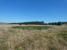
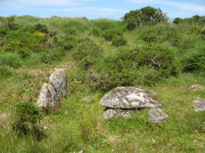
Bellever Tor (SW) Encircled Cairn
OS Map: SX 64144 76275
HER record: MDV5885
Megalithic Portal: 3056
Alternate name: Bellever Tor 2 Encircled Cairn
ShortName: EC:Bellever 2
Butler map: 27.20.2
Grinsell: LYD 59a
Turner: F18
Notes: cairn, it does not appear to have been excavated, although there is a slight disturbance at the top centre where large granite stones are bared. At the north west extreme are two stones, the positions of which indicate this being part of the retaining circle, no others remain. Height 0.8m, diameter 5.0m. Turner F18. See also: Dartmoor Explorations: Antiquities of Black Newtake and Environs. NGR taken from Dartmoor Explorations (Steve Grigg).
Nearby sites: SX64147628
Black Newtake (N) No. 1 Ring Setting Cairn and Cist
OS Map: SX 63919 76067
HER record: MDV5888
Megalithic Portal: 45738
PMD: Black Newtake N.
Alternate name: Bellever Tor 3 Ring Setting Cairn and Cist
ShortName: CT Bellever 3
Butler map: 27.20.3
DPD page: 119
Grinsell: LYD 60
Turner: D5
Barrow Report: 57
Notes: Further coverage on Lakehead Hill page. Lethbridge Cist 1 diagram p.119 and photo top p.119. Butler Bellever Tor (Cairn 3) - Vol. 2. Map 27.20.3 (diagram pp.52-3). Site revisited 04/09/23 and the site is very overgrown unlike in 2010. The exact location by Garmin is SX 63919 76067 now used on this record. See also: Dartmoor Explorations: Antiquities of Black Newtake and Environs
Nearby sites: SX63927607
Black Newtake (b) Stone Ring Cairn Circle
OS Map: SX 63863 76038
HER record: MDV5889
Megalithic Portal: 45841
Alternate name: Bellever Tor 4 Stone Ring Cairn Circle
ShortName: RC Bellever 4
Butler map: 27.20.4
DPD page: 119
Grinsell: LYD 61
Turner: A50
Barrow Report: 57
Notes: "Cairn visible as unbroken circular bank 11.5 metres in external diameter with a bank 2.4 to 3.7 metres wide by 0.75 metres high enclosing a flat platform circa 6 metres diameter and 0.5 metres above ground surface. Some small stones appear in the north and east margins, and several larger stones are visible on the platform." Lethbridge diagram p.119 (Cairn near Cist 1) - no photo.
Nearby sites: SX63867604
Bellever Tor 5 Cairn Circle
OS Map: SX 63859 75989
HER: No record found
ShortName: CN Bellever 5
Butler map: 27.20.5
Notes: This record used to link to HER record MDV 5889 but that is clearly Bellever Tor 4 (ring cairn). This site is mentioned within that HER entry but it is a separate monument. Arguably it needs its own record. NB. Butler cairns 4 and 5 had previously been transposed in the listings here. The original records for both have been retained and the Butler number corrected and the grid references corrected. This was previously listed as Butler cairn 4 and is now listed correctly as cairn 5. See also: Dartmoor Explorations: Antiquities of Black Newtake and Environs
Nearby sites: SX63867599
Black Newtake (C) No. 3 Ring Setting Cairn and Cist
OS Map: SX 63893 75869
HER record: MDV5890
Megalithic Portal: 34908
PMD: Black Newtake Central
Alternate name: Bellever Tor 6 Ring Setting Cairn and Cist
ShortName: CT Bellever 6
Butler map: 27.20.6
DPD page: 120
Grinsell: LYD 62
Turner: D4
Barrow Report: 57
Notes: Further coverage on Lakehead Hill page. Lethbridge diagram p.119 Cist 2 and photo top p.120. Butler Bellever Tor - Vol. 2. Map 27.20.6 (Cairn 6 diagram pp.52-3).
Nearby sites: SX63897587
Bellever Tor 7 Reported Cairn
OS Map: SX 63866 75782
HER record: MDV5951
ShortName: CN-Bellever 7
Butler map: 27.20.7
Grinsell: LYD 63
Turner: A40
Barrow Report: 57
Notes: Probably a hut circle
Nearby sites: SX63877578
Black Newtake (E) No. 5 Ring Setting Cairn and Cist
OS Map: SX 63853 75734
HER record: MDV5950
Megalithic Portal: 45744
PMD: Black Newtake S.
Alternate name: Bellever Tor 8 Ring Setting Cairn and Cist
ShortName: CT Bellever 8
Butler map: 27.20.8
Grinsell: LYD 64
Turner: D7
Barrow Report: 57
Notes: "Turf and gorse covered cairn. Approximately 6 metres in diameter with a maximum height of 0.35 metres. A depression in the top possibly marks the site of a cist with one large leaning or recumbent stone detectable under the turf at the east end" "Small orthostatic circle, diameter 6.5 metres, with central cist. Only one stone remains. Part of group with similar thin rectangular slabs, now eroded". Further coverage on Lakehead Hill page. Butler Bellever Tor - Vol. 2. Map 27.20.8 (Cairn 8 diagram pp.52-3). See also: Dartmoor Explorations: Antiquities of Black Newtake and Environs
Nearby sites: SX63857573
Dunnabridge Common Platform Cairn Circle and Cist
OS Map: SX 63585 75470
HER record: MDV5952
Megalithic Portal: 37603
PMD: Smith Hill
Alternate name: Bellever Tor 9 Platform Cairn Circle and Cist
ShortName: CT Bellever 9
Butler map: 27.20.9
DPD page: 120
Grinsell: LYD 65
Turner: E37
Barrow Report: 58
Notes: Lethbridge Cist 3 diagram p.119 and photo bottom p.120. Butler Bellever Tor (Cairn 9) - Vol. 2. Map 27.20.9 (diagram p52-3). See also: Dartmoor Explorations: Antiquities of Black Newtake and Environs
Nearby sites: SX63597547
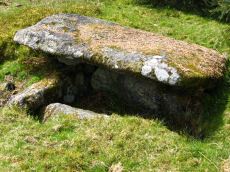
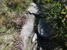
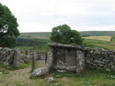
Dunnabridge Pound Farm Newtake Cist
OS Map: SX 64086 75691
HER record: MDV5891
Megalithic Portal: 45751
PMD: Dunnabridge Newtake
Alternate name: Bellever Tor 10 Cist
ShortName: CT Bellever10
Butler map: 27.20.10
Butler Vol 5: p.60 & Fig.39
DPD page: 121
Grinsell: LYD 66
Barrow Report: 59
Notes: Only one side of this cist remains. Further coverage on Lakehead Hill page. Lethbridge Cist 4 diagram p.119 and photo top p.121. Butler Bellever Tor - Vol. 2. Map 27.20.10 (Cairn 10 diagram pp.52-3). See also: Dartmoor Explorations: Antiquities of Black Newtake and Environs
Nearby sites: SX64097569
Bellever Tor 11 Reported Cairn
OS Map: SX 64170 76090
HER record: MDV27221
ShortName: CN?Bellever11
Nearby sites: SX64177609
Bellever Tor 12 Cairn
OS Map: SX 64530 76860
HER record: MDV52765
ShortName: CN:Bellever12
Notes: "Low flat-topped cairn situated immediately outside the eastern edge of a settlement and field system on the gently sloping northern flank of Bellever Tor. The heather and moss covered mound measures 3.6 metres in diameter with a maximum height of 0.35 metres. It is probably sepulchral in origin and appears to be undisturbed."
Nearby sites: SX64537686
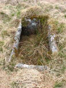
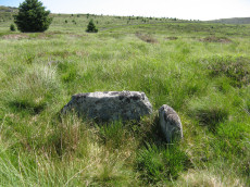
Bellever Tor 13 (site of) Reported Cist
OS Map: SX 64330 76764
HER record: MDV5953
PMD: Bellever Settlement
ShortName: CT-Bellever13
Notes: Two parallel boulders, a natural occurence, protrude from the long grass in the vicinity of Worth's reference but no cist could be identified.
Nearby sites: SX64337676
Bellever Tor N. Enclosed Settlement
OS Map: SX 64485 76808
HER record: MDV27672
Megalithic Portal: 24263
ShortName: ES BelleverTor
Notes: The photo was taken at SX 64510 76849.
Nearby sites: SX64497681
Bellever Settlement
OS Map: SX 64600 76700
HER record: MDV5919
Megalithic Portal: 23723
ShortName: ST:Bellever
Notes: Hut circle at Bellever excavated in recent years. See also A dig in Devon reveals how life was lived 3,500 years ago: from cookery to DIY and Bellever's bustling Bronze Age uncovered
Nearby sites: SX64607670
Bellever Rock Shelter
OS Map: SX 64400 76500
HER record: MDV5941
ShortName: RS Bellever
Notes: Natural crevice in Bellever Tor forming a possibly built up Rock Shelter as reported by Robert Burnard (1914). Date of shelter not known for certain but signs of ancient habitation and numerous flints found.
Nearby sites: SX64407650
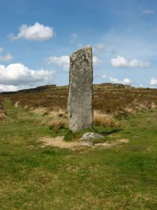
Laughtor Man Standing Stone
OS Map: SX 65223 75389
HER record: MDV6001
Megalithic Portal: 2017
PMD: Laugh Tor Man
ShortName: SS Laughtor
Butler map: 28.12
Butler Vol 5: p.215 & Fig.149
DPD page: 122
Notes: The longstone is 2.4 m high and was found prostrate on a cairn which was excavated by Burnard. The cairn contained "a great quantity of charcoal and peat ashes". The longstone was restored in 1903. A double stone row heads to the longstone. Breton p.41 a huge menhir I found in June 1913, lying on the ground. It was then 16 ft long, but 4 ft. had been broken off. It was re-erected by the late Rev S. Baring Gould, with the Duchy appliances, and he told me that they could not join the two pieces, so he erected it as it now stands; it is 8.5 ft high, 2ft 6in wide and 1.5 ft thick. The stone row runs E. 720 ft.. See also, Legendary Dartmoor: The Prehistoric Complex of Laughter Tor
Nearby sites: SX65227539
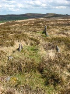
Laughter Tor E. Stone Row
OS Map: SX 65222 75393
HER record: MDV53417
Megalithic Portal: 2017
The Stone Rows of GB: Laughter Tor 1
PMD: Laugh Tor I Stone Row
Alternate name: Laughter Tor 1 Stone Row
ShortName: SR Laugh Tor E
Butler map: 28.12.1
DPD page: 122
Notes: Butler Laughter 1. Double row interrupted by a new-take wall. row is robbed near wall. "Bronze Age standing stone 2.65 metres high, 0.7 metres wide and 0.52 metres thick, set into a small cairn. About 18 metres to the south east is a double stone row orientated north west to south east and consisting of at least 23 upright stones and a further 9 displaced ones averaging about 1.7 metres apart. The standing stone was re-erected in 1893 and again in 1911 and the cairn was excavated in 1903". Lethbridge pp.121-122. Breton p.41.
Nearby sites: SX65227539
Laughter Tor W. Stone Row
OS Map: SX 65207 75389
HER record: MDV6002
Megalithic Portal: 52739
The Stone Rows of GB: Laughter Tor 2
PMD: Laugh Tor II Stone Row
Alternate name: Laughter Tor 2 Stone Row
ShortName: SR Laugh Tor W
Butler map: 28.12.2
Butler Vol 5: p.215 & Fig.149
DPD page: 122
Notes: Butler Laughter 2. "A double stone row at about 395m OD cuts across the gentle SW projecting spur of Laughter Tor in an area of heather and rough grass some 12m WSW of the standing stone 'Laughter Man'. The stones, although all relatively small in size, form two good slightly curving rows oriented about 295 degs. and 0.7m to 1.2m apart, consisting of thirteen stones extending from SX 6519075381 some 15m ESE to SX 6520475375. Now visible are six stones in each row with a single stone at the NW end. Originally there may have been at least ten in each row at intervals of about 1.2m". Lethbridge pp.121-122.
Nearby sites: SX65217539
Laughter Tor Stone Row Cairn
OS Map: SX 65220 75380
HER record: MDV66340
ShortName: CN:Laughter 1
Butler map: 28.12
Grinsell: LYD 68a
Barrow Report: 22
Notes: HER: Cairn at west end of Laughter Tor stone row of 5.5 metres diameter by 0.2 metres high. This cairn may be original or the result of restoration work when the standing stone was re-erected.
Nearby sites: SX65227538
Laughter Tor S. (8) Reported Cairn
OS Map: SX 65300 75500
HER record: MDV6083
ShortName: CN?Laughter 2
Butler map: 28.12
Barrow Report: 22 56
Notes: 8 small cairns recorded by Burnard in 1903 - one contained almost a wheelbarrow full of charcoal. These can no longer be located.
Nearby sites: SX65307550
Laughter Tor Reported Cairn
OS Map: SX 65380 75320
HER record: MDV6003
ShortName: CNxLaughter 3
Grinsell: LYD 68b
Notes: There is no evidence of a cairn at the W end of the alignment
Nearby sites: SX65387532
Dunnabridge Pound
OS Map: SX 64620 74650
HER record: MDV6272
Megalithic Portal: 10635
PMD: Dunnabridge Pound
ShortName: PD Dunnabridge
Notes: Dunnabridge Pound probably has its origins in the prehistoric period as evidenced by the slight traces of hut circles within it. The pound underwent reconstruction in the medieval period and was used in the drifts to hold cattle found illegally pasturing on the moors.
Nearby sites: SX64627465
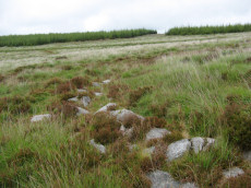
Cocks Lake Cairn
OS Map: SX 65400 74760
HER record: MDV54389
ShortName: CN?Cocks Lake
Butler map: 28.6
Barrow Report: 22
Notes: Butler: " A stony mound on the edge of the leat ... is probably a prehistoric cairn. It has been dug into and the stones scattered outwards from a central pit, but there is no sign of a cist. Possibly this is the ruined cairn that Burnard 'examined in Brimpts newtake but without result'" (Barrow Report 22).
Nearby sites: SX65407476
Huccaby Rings Inner Enclosed Settlement
OS Map: SX 65820 73810
HER record: MDV6405
Megalithic Portal: 4616
ShortName: ES HuccabyInn
Notes: "Huccaby Ring a circular banked enclosure south-east of Huccaby Tor; smaller than Outer Huccaby Ring that lies to the north-west of the Tor. A Bronze Age enclosure visible as a turf covered stoney bank measuring 3.5 metres wide and stading to a maximum height of 0.7 metres. There is no obvious sign of an entrance."
Nearby sites: SX65827381
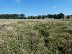
Huccaby Rings Outer Enclosed Settlement
OS Map: SX 65553 74441
HER record: MDV6397
Megalithic Portal: 4614
ShortName: ES HuccabyOut
Notes: "Outer Huccaby Ring earthwork; a sub-rectangular banked enclosure. The bank is grassed over rubble. There is a probable entrance on the south-west side. A hillslope enclosure in rough moorland measuring 105 metres east-west and 95 metres north-south with a bank of small stones averaging 0.6 metres high. It is of prehistoric date with later additions." In more recent years the formerly grass covered site has become gorse and heather covered as can be seen in the photo of the northern section. In 2022-2024 work has been done by the Dartmoor Preservation Association to clear the gorse from the bank.
Nearby sites: SX65557444
Huccaby Newtake Reported Cairn
OS Map: SX 65630 74210
HER record: MDV25457
ShortName: CN?Huccaby New
Nearby sites: SX65637421
Muddilake Newtake Reported Cist
OS Map: SX 62654 75194
HER record: MDV5893
Megalithic Portal: 45745
PMD: Muddilake Newtake
ShortName: CT:Muddilake
Grinsell: LYD 105
Turner: A21
Barrow Report: 58
Notes: NMR states "A hut circle, not a cairn circle". This is almost certainly not a cist. "The measurements do not conform to those of Prowse but nothing else can be seen in the vicinity. It is most unlikely that these stones represent the remains of a cist, but are a natural occurrence." (see also duplicate HER record 5894 and SiteID=2547). This "cist" entry was listed by Dixon, however, it seems a dubious entry. This is not listed by Butler, the relevant map is Vol. 2. Map 29.9.
Nearby sites: SX62657519
Muddilake Reported Cairn
OS Map: SX 62775 75096
HER record: MDV5895
ShortName: CN?Muddilake 1
Grinsell: LYD 106
Turner: A38
Barrow Report: 58
Notes: Hut Circle - listed by Butler as a cairn. This is the second cairn that Worth mentions in Barrow Report 58. "A cairn, 4 feet in diameter, but so robbed as to be reducedto little more than a marginal ring".
Nearby sites: SX62787510
Muddilake (N) Reported Cairn
OS Map: SX 62761 75202
HER record: MDV48858
ShortName: CN?Muddilake 2
Turner: A37
Notes: Probable remains of a hut circle; this feature has previously been identified as a cairn. One of several associated with settlement site north of Muddilake Brook. Probably the second hut circle on NMR entry 442677
Nearby sites: SX62767520
Muddy Lakes Newtake Reported Cairn
OS Map: SX 62580 75180
HER record: MDV5894
Megalithic Portal: 45745
Alternate name: Muddilake West Reported Cairn
ShortName: CT?Muddilake 3
Barrow Report: 58
Notes: Hut circle or cairn? Grinsell states "Traces of cairn with central slab, probably side-slab of cist. Diameter 6.0 meters, height is slight." Other observers say "no trace of cist". This is a duplicate of record 382 (HER 5893). Dixon #82. Bar Rep. 58 (TDA 71. 1939 illustration p.69).
Nearby sites: SX62587518
Riddon Ridge summit Reported Cairn
OS Map: SX 66330 76630
HER record: MDV19985
ShortName: CN:Riddon 1
Butler map: 18.1.23
Grinsell: LYD 67b
Notes: HER: cairn discovered. Ridge siting. Diameter 4.5m, height 0.3m.
Nearby sites: SX66337663

Riddon Corner Reported Cairn
OS Map: SX 67140 76360
HER record: MDV64234
ShortName: CN?Riddon 2
Butler map: 18.2.7
Notes: Butler: The cairn at 7 (8.0 x 1.0 m), 5 m from the field wall and close to a reave, is probably prehistoric. A slight depression in its flat suface suggests it has been dug and a track cutting across the eastern edge has also caused some slight damage. A pile of stones in a similiar relationship to the next reave to the south is more likely to be clearance from the field.
HER entry: A turf-covered mound measuring 8.2 by 7.2 by 0.7 metres high. The mound bears some indications of disturbance. It is uncertain whether it is a barrow or the result of more recent field clearance.. Possibly visible on Lidar.
Nearby sites: SX67147636
Riddon Ridge S.E. Reported Cist
OS Map: SX 66950 76350
HER: No record found
PMD: Riddon Ridge 1
ShortName: CT:Riddon 3
Butler map: 18.2.8
Grinsell: LYD 67a
Barrow Report: 33
Notes: Butler: A few small set stones show around the edge of another [cairn] at 8 (5 x 0.4m) It appears to be untouched, too small to attract the attention of casual diggers. It is, however, approximately in the position of the cairn excavated by R. Burnard in 1914, who may have carefully replaced the stones he removed. His cairn was more compact before excavation (3.7 x 0.8) so if it is the same his restoration has allowed considerable spread. To his surprise, Burnard was not the first to investigate it, but he was still able to recover part of a pot, a flint, pieces of quartz and some charcoal contained within a stone-lined pit at the centre.. See Barrow Report 33. No specific HER entry but mentioned on MDV129868.
Nearby sites: SX66957635

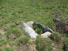
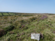
Riddon Ridge S. Cist
OS Map: SX 66780 76269
HER record: MDV5986
PMD: RHR Stone
ShortName: CT Riddon 4
Butler map: 18.2.9
Grinsell: LYD 67
Notes: Known as the RHR stone. HER: A turf-covered cairn situated near the crest of the south-eastern slope of Riddon Ridge. It measures 8.4m north to south by 10.0m and stands to a maximum 0.9m high. There is no obvious trace of a kerb. Much stone is visible protruding through the turf and an amorphous hollow is situated slightly west of centre. A recumbent slab inscribed with the letters 'RHR' lies in the latter. The hollow possibly marks the site of an unrecorded excavation or it is the result of erosion around the originally upright inscribed stone..
Nearby sites: SX66787627
Riddon Ridge (E Slope) Reported Cairn
OS Map: SX 66800 76600
HER record: MDV129868
ShortName: CN?Riddon 5
Grinsell: LYD 67ai
Notes: HER: A cairn is alleged at this location but could not be located during field investigation.Grisell NGR SX 6680 7660. Many hut circles in this area. Also could possibly be duplicate of NMR 442461. See LYD 67a
Nearby sites: SX66807660
Riddon Ridge 6 Reported Cairn
OS Map: SX 66740 76580
HER record: MDV26459
ShortName: CNxRiddon 6
Turner: D1
Notes: Hut Circle. Formerly listed as HER entry MDV16536 which has been deleted. This record has been updated and linked to MDV26459 on 06/12/24 which has a reference to Turner's listings which is the origin of this record. It is possible SiteID=2638 is a duplicate of SiteID=2562. Both now point to the same HER record, so presumably the HER have concluded they are the same feature.
Nearby sites: SX66747658
Riddon Ridge 7 Reported Cist
OS Map: SX 66740 76580
HER record: MDV26459
PMD: Riddon Ridge 2
ShortName: CN?Riddon 7
Grinsell: LYD 67c
Turner: A25
Notes: Hut circle or cairn? Radcliffe: "Grinsell lists this as a cist in his Table III with GR 6664 7657, but does not mention this in his List B. His grid reference differs from that of Turner, who does not mention a cist. SMR ref is 666 765. There is a hut circle near these grid references."
It is possible SiteID=2638 is a duplicate of SiteID=2562. Both now point to the same HER record, so presumably the HER have concluded they are the same feature.
Nearby sites: SX66747658
Page last updated 10/12/24