
Guide to the Monuments on Haytor, Hound Tor and Trendlebere Down

Table of Ritual and Burial Monuments on Haytor, Hound Tor and Trendlebere Down
The following table lists the records currently in this Guide Map. For an explantion of the Guide Maps and a table of all 62 Guide Maps, follow this link: Guide List Table. Introductory text will be added to each guide list in 2025. Notes on duplication and omissions will appear below the table once checks have been finalised.
Notes on possible duplications and omissions
Black Hill 6-12 Cairns The HER lists Black Hill 1-5. Butler lists several more, see fig. 2.2 Vol 1 p.28PS. These notes are to assist untangling complicated records and are neither permanent nor a criticism of the HER who do a fantastic job! The author finds it easier to systematically work through these records (2000+ of them) and add these notes, which are then to be communicated with the HER, if appropriate, it is a pragmatic way of dealing with lots of data without continually stopping and starting.
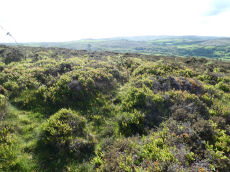
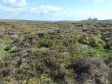
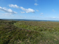
Haytor, Hound Tor and Trendlebere Down Guide Map
Guidance for walkers: The monuments featured in this database are archaeological treasures and need to be protected and preserved - please do not disturb any sites. Please check access and firing times before visiting sites, not all sites listed are on open access land. Firing ranges and boundaries of open access areas are marked on the OL28 OS Dartmoor Explorer map. Please stick to the country code and consider giving support to the numerous agencies that help to keep Dartmoor a fabulous natural and historic environment!
List of Ritual and Burial Monuments on Haytor, Hound Tor and Trendlebere Down
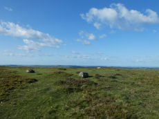
Black Hill 1 Cairn
OS Map: SX 76213 78605
HER record: MDV8044
ShortName: CN BlackHill 1
Butler map: 2.5.1
Grinsell: MAN 19
Notes: Butler refers to around twelve cairns at this location, most of which are quite insignificant. The four largest are still well defined and measure approximately 16.5 meters in diameter.
Nearby sites: SX76217861
Black Hill 2 Cairn
OS Map: SX 76169 78687
HER record: MDV8042
ShortName: CN BlackHill 2
Butler map: 2.5.2
Grinsell: MAN 18
Notes: Butler refers to around twelve cairns at this location, most of which are quite insignificant. The four largest are still well defined and measure approximately 16.5 meters in diameter.
Nearby sites: SX76177869
Black Hill 3 Cairn
OS Map: SX 76153 78735
HER record: MDV8043
ShortName: CN BlackHill 3
Butler map: 2.5.3
Grinsell: MAN 17
Notes: Butler refers to around twelve cairns at this location, most of which are quite insignificant. The four largest are still well defined and measure approximately 16.5 meters in diameter.
Nearby sites: SX76157874
Black Hill 4 Cairn
OS Map: SX 76281 78963
HER record: MDV8045
Megalithic Portal: 26733
ShortName: CN:BlackHill 4
Butler map: 2.5.4
Grinsell: MAN 16
Notes: "One of five cairns on Black Hill, all in a damaged condition." "Cairn with modern stoneheap at north end. Diameter 17.0 meters, height 0.7 meters."
Nearby sites: SX76287896
Black Hill 5 Cairn
OS Map: SX 76285 78989
HER record: MDV8046
ShortName: CN BlackHill 5
Butler map: 2.5.5
Grinsell: MAN 15
Notes: "A cairn at SX76297898 (note slight variation) with a maximum height at the rim of 0.5 meters with a probable retaining stone in the west. The centre of the cairn has been dug out. Other details: Plan."
Nearby sites: SX76297899
Black Hill 6 Reported Cairn
OS Map: SX 76175 78642
HER: No record found
ShortName: CN:BlackHill 6
Butler map: 2.5.6
Notes: The HER lists Black Hill 1-5. Butler lists several more, see fig. 2.2 Vol 1 p.28
Nearby sites: SX76187864
Black Hill 7 Reported Cairn
OS Map: SX 76190 78960
HER: No record found
ShortName: CN:BlackHill 7
Butler map: 2.5.7
Notes: The HER lists Black Hill 1-5. Butler lists several more, see fig. 2.2 Vol 1 p.28
Nearby sites: SX76197896
Black Hill 8 Reported Cairn
OS Map: SX 76170 78950
HER: No record found
ShortName: CN BlackHill 8
Butler map: 2.5.8
Notes: The HER lists Black Hill 1-5. Butler lists several more, see fig. 2.2 Vol 1 p.28
Nearby sites: SX76177895
Black Hill 9 Reported Cairn
OS Map: SX 76150 78660
HER: No record found
ShortName: CN:BlackHill 9
Butler map: 2.5.9
Notes: The HER lists Black Hill 1-5. Butler lists several more, see fig. 2.2 Vol 1 p.28. Grid reference is estimated on Google Earth by comparison to Butler's diagram.
Nearby sites: SX76157866
Black Hill 10 Reported Cairn
OS Map: SX 76102 78655
HER: No record found
ShortName: CN BlackHill10
Butler map: 2.5.10
Notes: The HER lists Black Hill 1-5. Butler lists several more, see fig. 2.2 Vol 1 p.28. Grid reference is estimated on Google Earth by comparison to Butler's diagram.
Nearby sites: SX76107866
Black Hill 11 Reported Cairn
OS Map: SX 76167 78646
HER record: MDV26562
ShortName: CN:BlackHill11
Butler map: 2.5.11
Notes: The HER lists Black Hill 1-5. Butler lists several more, see fig. 2.2 Vol 1 p.28. Grid reference is estimated on Google Earth by comparison to Butler's diagram.
Nearby sites: SX76177865
Black Hill 12 Reported Cairn
OS Map: SX 76167 78676
HER: No record found
ShortName: CN:BlackHill12
Butler map: 2.5.12
Notes: The HER lists Black Hill 1-5. Butler lists several more, see fig. 2.2 Vol 1 p.28. Grid reference is estimated on Google Earth by comparison to Butler's diagram.
Nearby sites: SX76177868
Black Hill A (Manaton) Ancient Pool
OS Map: SX 76188 78885
HER record: MDV127184
ShortName: PO:BlackHillA
Notes: "The pool at Black Hill measures 10-11m. One of over 40 such 'sacred' pools identified on Dartmoor that are thought to have potentially been designed during the prehistoric period."
Nearby sites: SX76197889
Black Hill B (Manaton) Ancient Pool
OS Map: SX 76171 78465
HER record: MDV127185
ShortName: PO:BlackHillB
Notes: "The second pool at Black Hill (B) is interesting as it possesses a double ring bank enclosing a distinct sunken hollow. Externally the feature is about 20 metres in diameter, and the pool hollow about 10 metres. Compared with the King’s Stables pool and earthwork at Navan, County Armagh which is about 25 metres in diameter x 3.5 metres deep, dating to around 1000 BC (although this feature has a shallower form). One of over 40 such 'sacred' pools identified on Dartmoor that are thought to have potentially been designed during the prehistoric period, and may have been used to deposit votive items, although these Dartmoor examples may have alternative significance as designed prehistoric elements in the landscape. Many are located on ridge tops and in conjunction with cairns, stone rows and other prehistoric features. Further research may well reveal more about these interesting features."
Nearby sites: SX76177847
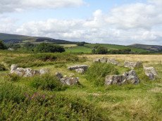
Haytor Down Stone Ring Cairn Circle
OS Map: SX 76700 78110
HER record: MDV48849
Megalithic Portal: 45820
Alternate name: Haytor Down N.1 Stone Ring Cairn Circle
ShortName: RC:Haytor N1
Butler map: 2.6.1
Butler Vol 5: p.190 & Fig.132
Turner: A7
Notes: "Ring cairn on Haytor Down. Stone ring 21.0 meters internal diameter, with bank 1.5 meters wide and 0.4 meters high. Modern entrance." One of group of 4 cairns - see Butler for diagram in Vol 1 and 5.
Nearby sites: SX76707811
Haytor Down N.2 Cairn
OS Map: SX 76626 78145
HER record: MDV8106
ShortName: CN Haytor N2
Butler map: 2.6.2
Butler Vol 5: p.191 & Fig.133
Grinsell: ILS 6
Notes: One of group of 4 cairns - see Butler for diagram in Vol 1 and 5.
Nearby sites: SX76637815
Haytor Down N.3 Reported Cairn
OS Map: SX 76599 78154
HER record: MDV8105
ShortName: CN-Haytor N3
Butler map: 2.6.3
Butler Vol 5: p.191 & Fig.134
Notes: One of group of 4 cairns - see Butler for diagram in Vol 1 and 5. Maybe medieval ditch. "Sited at SX76597814 on a gently sloping northern summit of the Haytor Down spur, is a circular ditch with a level interior and slight external bank. The well-defined ditch has a V profile and a diameter of 24m. It is 1.9m wide and survives to a depth of 0.6m. The external bank, where visible is approximately 1.5m wide. The southern quadrant has been overlain by a modern footpath. The unsilted appearance of the ditch suggests this is not a prehistoric feature."
Nearby sites: SX76607815
Haytor Down N.4 Cairn
OS Map: SX 76545 78161
HER record: MDV79704
ShortName: CN Haytor N4
Butler map: 2.6.4
Butler Vol 5: p.191 & Fig.135
Notes: One of group of 4 cairns - see Butler for diagram in Vol 1 and 5. "One of three cairns forming a linear group in the centre of the ridge to the east of Smallacombe Rocks. A large 17 metre diameter flat turfed mound with two orthostats on the circumference."
Nearby sites: SX76557816
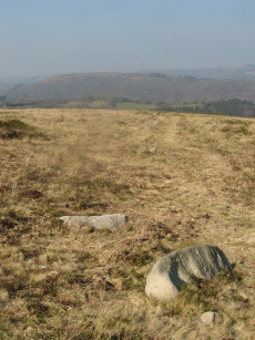
Haytor Down Cairn
OS Map: SX 76337 78318
HER record: MDV8104
ShortName: CN:Haytor Down
Grinsell: ILS 5
Notes: "A very flat and ruinous cairn sited near the Three Parishes Stone at SX76347831. Its position coincides with a reave which occupies the parish boundary and seems to respect the position of the cairn."
Nearby sites: SX76347832
Haytor Down North A Ancient Pool
OS Map: SX 76269 78331
HER record: MDV127210
ShortName: PO:HaytorDownA
Notes: "A pool measuring 18 by 14m. One of over 40 such 'sacred' pools identified on Dartmoor that are thought to have potentially been designed during the prehistoric period. Lies near a prehistoric reave and cairn."
Nearby sites: SX76277833
Haytor Down North B Ancient Pool
OS Map: SX 76493 78182
HER record: MDV127211
ShortName: PO:HaytorDownB
Notes: "A pool measuring around 5m. One of over 40 such 'sacred' pools identified on Dartmoor that are thought to have potentially been designed during the prehistoric period. Lies near a prehistoric cairn and enclosure."
Nearby sites: SX76497818
West Emsworthy Quarry Cairn
OS Map: SX 75784 77745
HER record: MDV78602
ShortName: CN:West Emsw
Butler map: 1.10
Notes: HER: Close to the main quarry junction to the west side of Haytor Down is a turf-covered mound 9 metres diameter by 1.2 metres high which has been trenched to expose a neatly coursed interior structure.
Nearby sites: SX75787775
Owlacombe Burrow Reported Cairn
OS Map: SX 77640 77630
HER record: MDV8111
ShortName: CN?Owlacombe
Grinsell: B:ILS 6a
Notes: LVG 5/10/1975 name of boundary stone on outcrop.
Nearby sites: SX77647763
Smallacombe Rocks Settlement
OS Map: SX 75700 78200
HER record: MDV8055
Megalithic Portal: 31843
ShortName: ST:Smallacombe
Nearby sites: SX75707820
Houndtor Down Ancient Pool
OS Map: SX 74193 78601
HER record: MDV127214
ShortName: PO:Houndtor
Notes: "A pool measuring around 50 by 17m. One of over 40 such 'sacred' pools identified on Dartmoor that are thought to have potentially been designed during the prehistoric period. Lies south of a prehistoric cairn."
Nearby sites: SX74197860
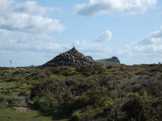
Houndtor Down Ring Setting Cairn and Cist
OS Map: SX 74106 78772
HER record: MDV7398
Megalithic Portal: 24187
PMD: Hound Tor
ShortName: CT Houndtor
Butler map: 8.6
Butler Vol 5: p.179 & Fig.121
DPD page: 151
Grinsell: MAN 13
Turner: D8
Barrow Report: 53 56
Notes: "A ring cairn surviving as a mound 6.5 metres in diameter and 0.15 metres high. It is defined, except on the west side, by a ring of at least 19 close set granite stones. In the centre of the cairn is a north to south orientated cist, with both end stones and the western side stone remaining visible.". Butler Vol. 1. Map 8.6 (diagram Vol. 5. p.179).
Nearby sites: SX74117877
Trendlebere Down Stone Row
OS Map: SX 76600 79239
HER record: MDV8076
Megalithic Portal: 2171
The Stone Rows of GB: Trendlebere Down
PMD: Trendlebeare Down Stone Row
ShortName: SR Trendlebere
Butler map: 2.7
DPD page: 151
Notes: "A stone row 100ft. to the north of the Haytor-Manaton road." 18 stones of the stone row can be identified of which 9 are fallen and 9 upright stones. The fallen stones vary in length between 3'4" and 4'6"; the upright ones between 6" and 2'4".
Nearby sites: SX76607924
Trendlebere Row S. Cairn
OS Map: SX 76620 79230
HER record: MDV8077
Megalithic Portal: 4625
Alternate name: Trendlebere Stone Row S Cairn
ShortName: CN TrendleberS
Butler map: 2.7
Grinsell: MAN 14
Notes: HER: Cairn at southern end of stone row MDV8076 on Trendlebere Down north-east slope of Black Hill. The cairn at the southern end of the row is centred at SX 7662 7923. Its perimeter can be traced on the ground but only a grass covered crescent of stones survives in the eastern half.
Nearby sites: SX76627923
Trendlebere Stone Row N Clearance Cairn
OS Map: SX 76620 79350
HER record: MDV8076
ShortName: CN?TrendleberN
Grinsell: B:MAN 14a
Notes: Grinsell, N. Yarner Wells 'cairn' at lower (northern) end of stone row 48, thought to be an 'island' left by turf cutters. Worth 1953, 227 A Bronze Age stone row, with the remains of a cairn at the southern end. Worth (1953) mentions another cairn at the northern end, but this feature has not been confirmed since; may be the result of turf cutting
Nearby sites: SX76627935
Bonehill Down Ancient Pool
OS Map: SX 73282 77812
HER record: MDV127194
ShortName: PO:BonehillDn
Notes: "The pool on Bonehill Down measures 12 by 6m. One of over 40 such 'sacred' pools identified on Dartmoor that are thought to have potentially been designed during the prehistoric period."
Nearby sites: SX73287781
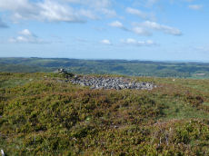
Chinkwell Tor Cairn
OS Map: SX 72930 78250
HER record: MDV20168
ShortName: CN:Chinkwell
Butler map: 7.3
Grinsell: WID 10
Turner: A63
Notes: HER: Cairn (or less probably ring cairn) built around granite outcrop, south segment missing. Diameter 22m, height 1m.
Nearby sites: SX72937825
Page last updated 10/12/24