
Guide to the Monuments on Chagford Common
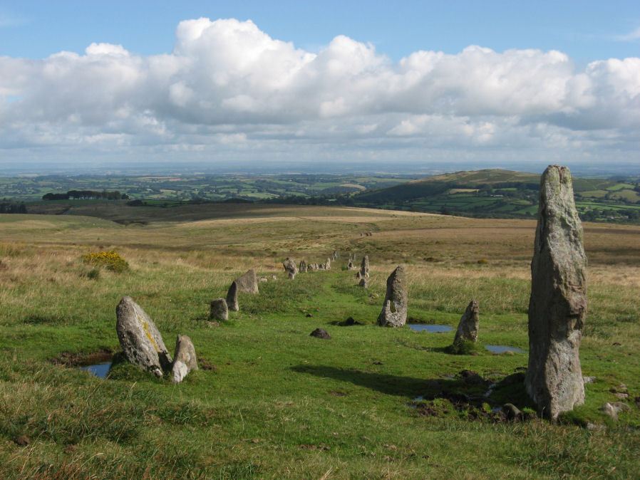
Table of Ritual and Burial Monuments on Chagford Common
The following table lists the records currently in this Guide Map. For an explantion of the Guide Maps and a table of all 62 Guide Maps, follow this link: Guide List Table. Introductory text will be added to each guide list in 2025. Notes on duplication and omissions will appear below the table once checks have been finalised.
Notes on possible duplications and omissions
Chagford Common cairns 1-5 NB. These feature on Guide 20 - Guide to the Monuments on Thornworthy and MetherallLeapra Rings NB. This entry was just added and there is not a problem with it, this is just a reminder to the author to take a look!
PS. These notes are to assist untangling complicated records and are neither permanent nor a criticism of the HER who do a fantastic job! The author finds it easier to systematically work through these records (2000+ of them) and add these notes, which are then to be communicated with the HER, if appropriate, it is a pragmatic way of dealing with lots of data without continually stopping and starting.
Chagford Common Guide Map
Guidance for walkers: The monuments featured in this database are archaeological treasures and need to be protected and preserved - please do not disturb any sites. Please check access and firing times before visiting sites, not all sites listed are on open access land. Firing ranges and boundaries of open access areas are marked on the OL28 OS Dartmoor Explorer map. Please stick to the country code and consider giving support to the numerous agencies that help to keep Dartmoor a fabulous natural and historic environment!
List of Ritual and Burial Monuments on Chagford Common

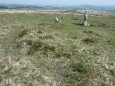
Hurston Ridge Stone Row
OS Map: SX 67260 82437
HER record: MDV6541
Megalithic Portal: 8345
The Stone Rows of GB: Hurston Ridge
PMD: Hurston Ridge Stone Row
ShortName: SR Hurston
Butler map: 25.9
Butler Vol 5: p.228 & Fig.161
DPD page: 136
Notes: .Worth: Watern Hill. "A stone alignment which includes two parallel lines of upright stones leading downslope for 143 metres from a round cairn. The lower end of the alignment is denoted by a blocking stone. Midway along the alignment a length of later enclosure walling crosses the row. The cairn at the upper end of the alignment measures 5.9 metres in diameter and stands up to a height of 0.6 metres. A large slab denoting the north eastern edge of the cairn may represent a second blocking stone of the associated alignment." A number of the stones were restored to their original sockets in 1894. A broken hand axe was discovered in the pit in which one of the stones had stood near to the menhir next to the cairn. First observed by Mr. George French of Postbridge.
Nearby sites: SX67268244
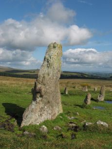
Hurston Ridge Standing Stone
OS Map: SX 67268 82444
HER record: MDV6541
Megalithic Portal: 8345
PMD: Hurston Ridge Standing Stone
ShortName: SS Hurston
Butler map: 25.9
DPD page: 136
Notes: Hurston Ridge is one of the best examples of a double stone now on Dartmoor. At the south end is a cairn 22 feet in diameter. The space between the rows widens intentionally as it approaches the cairn. The first stone from the south in the eastern row is the largest stone and stands 5 feet 10 inches high. Crossing suggests this may have been the original Heath Stone.
Nearby sites: SX67278244
Hurston Ridge Stone Row Cairn
OS Map: SX 67266 82438
HER record: MDV61939
PMD: Hurston Ridge Stone Row
ShortName: CN HurstonRow
Butler map: 25.9
Butler Vol 5: p.221 & Fig.154
Grinsell: CHA 5
Notes: The cairn at the upper end of the alignment measures 5.9 metres in diameter and stands up to a height of 0.6 metres. A large slab denoting the north eastern edge of the cairn may represent a second blocking stone of the associated alignment. A cinerary urn was found in the cairn. "The cairn has been throughly rifled ... It's shape is irregular ... but with no sign of the cist at one time visible here" (Butler Vol 2 p.30).
Nearby sites: SX67278244
Hurston Common Cairn
OS Map: SX 67660 83500
HER record: MDV61934
ShortName: CN:Hurston
Notes: HER: Cairn or hut circle on the north side of a D-shaped enclosure on west side of Hurston Main Reave on Chagford Common. NB. Formerly listed here as "Hurston Ridge" which duplicates the name of another cairn to the SW. Renamed to Hurston Common (07/09/2025).
Nearby sites: SX67668350

Hurston Ridge Settlement
OS Map: SX 67400 82500
HER record: MDV6668
Megalithic Portal: 34979
ShortName: ST Hurston
Butler map: 25.9
Nearby sites: SX67408250

West Vitifer Cist
OS Map: SX 67575 82802
HER record: MDV6615
Megalithic Portal: 34980
PMD: Chagford Common
ShortName: CT WestVitif 1
Butler map: 25.11
Grinsell: CHA 4
Barrow Report: 16
Notes: "Possible location of a Bronze Age cist, although when subject to field investigation in November 2002 the site was not found" "The cairn was partially excavated in 1897 by the Barrow Committee of the Devonshire Association. This working revealed a ring of slabs surrounding a cist which had not been previously examined. In the cist there was a complete Bronze Age beaker together with charcoal but no trace of a burial."
Nearby sites: SX67588280
West Vitifer (duplicate) Reported Cairn
OS Map: SX 67500 82600
HER: No record found
ShortName: CT?WestVitif 2
Notes: Possible location of a Bronze Age cist, although when subject to field investigation in November 2002 the site was not found. This record originates with the now discontinued NMR records and is most likely a duplicate of NMR 443785 i.e HER MDV6615, see West Vitifer Cist (SiteID=423)
Nearby sites: SX67508260
Lowton Brook Reported Cairn
OS Map: SX 66900 82870
HER record: MDV54605
ShortName: CN:Lowton Bk
Nearby sites: SX66908287
Lowton Brook W. Settlement
OS Map: SX 66300 83400
HER record: MDV104672
Megalithic Portal: 24262
ShortName: ST:LowtonBkW
Nearby sites: SX66308340
Chagford Common 6 Reported Cairn
OS Map: SX 67500 83000
HER record: MDV13039
ShortName: CN:Chagford 6
Grinsell: CHA 10a-i
Notes: 1902 exc. Unlocated - maybe CHA 7-9
Nearby sites: SX67508300

Shapley Common Standing Stone
OS Map: SX 69992 82248
HER: No record found
PMD: Shapley Common
ShortName: SS Shapley
Butler map: 23.5
Butler Vol 5: p.212
Notes: Possible standing stone, see Butler Vol V (1997) p 212.
Nearby sites: SX69998225
Shapley Common 1 Cairn
OS Map: SX 69690 82760
HER record: MDV64821
ShortName: CN:Shapley 1
Butler map: 23.5.1
Notes: HER: A platform cairn situated on the north facing slope of a prominent ridge, approximately 550 metres north of Shapley Tor. The cairn includes a 12 metre diameter circular platform standing 0.2 metres high. On this platform stands an ovoid flat-topped cairn measuring 9.7 metres east to west by 7.5 metres and standing a maximum of 0.8 metres high. The sides of the mound are heather clad while the top is grassy with some stone protruding. There is no evidence to suggest the presence of a cist or kerb.
Nearby sites: SX69698276
Shapley Common 2 Cairn
OS Map: SX 69869 82580
HER record: MDV6726
ShortName: CN:Shapley 2
Butler map: 23.5.2
Notes: A disturbed heather covered cairn lies on the gently sloping north east flank of Shapley Tor. The slightly ovoid mound measures 8.6 metres north to south by 8 metres and stands a maximum of 1 metres high. An ovoid hollow 2.5 metres by 3 metres and around 0.4 metres deep is visible in the centre of this feature.
Nearby sites: SX69878258
Leapra Rings Enclosure
OS Map: SX 70000 82600
HER record: MDV26675
ShortName: EN:Leapra
Notes: HER: Leapra Rings consists of three possibly Prehistoric circular features on Shapeley Common
Nearby sites: SX70008260
Page last updated 10/12/24