ROUTE: Long walk. Start Widecombe-in-the-moor Car Park. Finish Hay Tor Car Park. Distance 18km.
SITES OF INTEREST: Grimspound enclosed settlement. Hamel Down cairns; Hameldown Beacon, Two Barrows, Single Barrow, Broad Barrow. Hamel Down Cist. Grimslake Cist. Hound Tor Cist. Houndor medieval settlement
PUBLIC TRANSPORT: 271 Country Bus (summer Saturdays only) from Newton Abbot to Widecombe. The Stagecoach 39 bus from Exeter can be used to connect at Bovey Tracey.
NOTE: This bus service was still running in 2017 but in recent years bus services have been decimated by cuts - the walk can be adapted if the service no longer exists. It can also be shortened by doing a circular walk at either end.
Widecombe to Haytor via Grimspound
This walk starts from the village green in Widecombe. With the church behind you head up the road to Natsworthy and after 20 yards up the road turn left into Church Way, a steep lane climbing up on to Hameldown. Keep to the right as you ascend on to the open moor and make for the top of Hameldown.
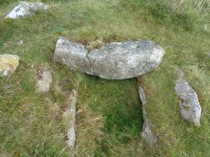
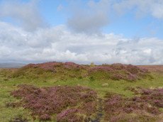
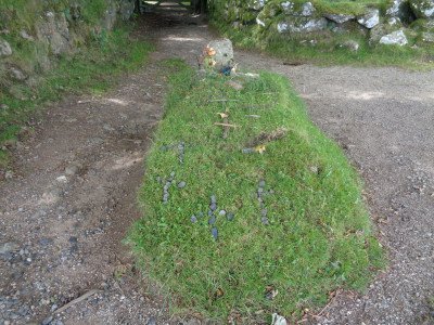
On the right-hand side of the path a short distance from the top of Hameldown is the Hameldown cist. Continue the climb to the top of the hill where you will encounter a large cairn known as the Hameldown Beacon. A wall approaches the cairn from the far side, instead of going over the wall stick to the left-hand side and keep walking in a northward direction.
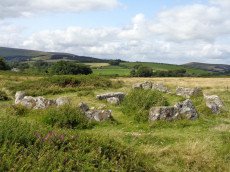
![]()
The main path continues north passing a number of massive cairns along the way. Beyond a wall on the left-hand side of the path are the two Blackaton Down cairns and a bit further on are the Two Barrows. Despite the size of the southern one of the Two Barrows pair it is easy to miss as a field wall has been built running into it. Further along the path is to be found Single Barrow and then Broad Barrow. It is near Broad Barrow that we will return to take a path heading east but for now keep heading straght on until you reach Grimspound.
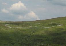
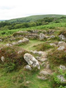
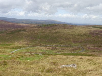
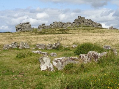
Grimspound is perhaps one of the best known prehistoric sites on Dartmoor. It is one of very many Bronze Age enclosed settlements. There are in fact some that are larger such as Riders Rings and the Yes Tor settlement although Grimspound has the more substantial enclosing walls. The site was intricately linked with the formation of the Dartmoor Exploration Committee (DEC) in the 1890s. Extensive excavations including reconstruction of parts of the enclosing wall and some of the hut circles inside took place in 1893. The first two reports of the Exploration Committee in the Transactions of the Devonshire Assocaition were based on the work at Grimspound. This was the start of two decades of intense exploration by the DEC.
There are some alternatives for this walk at Grimspound. For a shorter walk an alternative is to walk around 3 km to Warren House Inn and then return back to Widecombe. To do this drop down to the west on to the road and then head on to the path marked clearly on the Dartmoor Explorer (OL 28) map that loops around Headland Warren Farm. The Challacombe treble stone row is a small detour from the main path. Returning to the path the route drops down to remains of the Vitifer Mine. The lansdscape in this area is heavily scarred by the workings of the tin miners - that is the origins of the steep drops, the tears and crevices of Chaw Gully. Further south along the path following the stream are the remains of the Golden Dagger mine. To the north is a bit of a scramble up hill to the Warren House Inn.
For our walk an option is to digress a little to the north of Grimspound by climbing the northern side up on to Hookney Tor. The target is the Grimslake cist which is to the east of the top of Hookney Tor. We could get there more directly by heading east straight from Grimspound but this leads through the very wet terrain of Grimslake. There is a clue in the name!
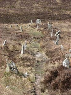
We now need to back track to Broad Barrow. From here we take a minor fork in the track that heads northwards and then swings round to the east just to the north of Berry Pound. As can be seen on the map there are routes which are more direct from Grimspound without back tracking quite so far. This route is suggested as it is a bit drier terrain to walk on. We are heading for the bridal path crossing the woods at Natworthy Manor. On the way down on the main path there is a large R.A.F Memorial stone (SX 71283 80700) which marks the site of a Second World War crash. For more on this, see R.A.F Memorial stone (opens in external website). A small detour can be made across the East Webburn River after descending most of the hill to look for the Hamedown NE stone row. This is fragmentary remains and the stones maybe difficult to find amongst the bracken.
The path will eventually lead to a gate on to the road at Natworthy Manor. Cross the road and keep to the bridal path for over a kilometer until it comes out on the road at Cripdon Down by Jays Grave. The grave famously always has fresh flowers laid on it. There is a sad story about this grave - it is the grave of a young woman who committed suicide back in the days when that meant that a burial was not allowed in consecrated ground. For more on this see the coverage on Legendary Dartmoor, Jays Grave (opens in external website)
At Jays Grave there are two alternatives routes both of which include nearly a kilometer stretch of walking along road. It is probably easiest to just follow the road to Hound Tor from Jays Grave. Alternatively, a longer route is to follow the bridal path across the other side of the road where it comes out on road that heads due south to Hound Tor. These are quiet roads and it is easy to walk alongside the road on the verge. Both of these routes arrive at Swallerton gate near Hound Tor which is a stop for the 271 Country Bus. So this is an alternative start or end point for this walk.
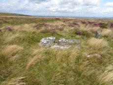
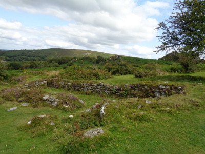
The route we need to follow climbs up towards Hound Tor and passes just to the south for the Hound Tor Cist which is an impressive cairn circle and cist. Just beyond Hound Tor just off to the left of the main path is the Houndtor medieval village which is a beautifully well preserved site.
From here the sheer Greator Rocks can be seen ahead. To the Left (north) there is a path that winds through the bracken to a gate. The path from here goes through the woods and crosses the Becka Brook. It comes out of the woods on the other side with a steep sloop densely covered in bracken above. The bridal path follows the river north away from Haytor but we need to climb uphill to the south to Smallacombe Rocks. So take a suitable right hand fork heading uphill. The climb is a bit steep in places but eventually we reach the top and Haytor Rocks can be seen to the south.
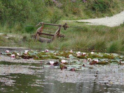
Head towards Haytor crossing the old tramway on the way. The Haytor Quarries are a beautiful spot well worth a visit. The ponds have a rather beautiful covering of water lillies. Across the road from here is the parking and Haytor Information point which is the pick up for the bus home.
Bibliography & references
Baring-Gould, Sabine, The Exploration of Grimspound. First Report of The Dartmoor Exploration Committee, T.D.A. Vol. 26 pp.101-21 (1894)
Baring-Gould, Sabine, Second Report of the Dartmoor Exploration Committee, T.D.A. Vol. 27 pp.81-92 (1895)
Chapman, Lesley, The Ancient Dwelling of Grimspound and Hound Tor: Two Deserted Settlements in th, (1996)
GPS Download of this walk
- Widecombe Walk in Garmin MapSource *.GDB format: widecombewalk.gdb
- Widecombe Walk in GPS eXchange Format *.GPX format: widecombewalk.gpx
- Widecombe Walk in Google Earth (keyhole) Markup Language *.KML format: widecombewalk.kml
Page last updated 22/08/17