
Prehistoric sites within 3km of SX 81250 85250
Guidance for walkers: The monuments featured in this database are archaeological treasures and need to be protected and preserved - please do not disturb any sites. Please check access and firing times before visiting sites, not all sites listed are on open access land. Firing ranges and boundaries of open access areas are marked on the OL28 OS Dartmoor Explorer map. Please stick to the country code and consider giving support to the numerous agencies that help to keep Dartmoor a fabulous natural and historic environment!
About the database listings: In all listings clicking on the photo or the site name will open a page for the site with a larger photo and further details from the database. The database now has over 6680 records covering nearly all publicly listed sites on Dartmoor including around 4800 round houses. This level of detail is of interest to archaeologists but tends to swamp listings of sites more likely to be of interest for walkers. For this reason, the listings default to around 550 core sites only. These are the stone circles, stone rows and the ring cairns listed by Turner. The default search radius is 2 km. The controls below the map can be used to start a new search by entering a 6- or 8-digit reference (without the prefix "SX"). The search radius can be specified and you can add incremental Display layers of detail on top of the core sites. If using a more detailed layer you will need to decrease the search radius to avoid getting hundreds of search results.
- Core sites Default listing of core sites consisting of stone circles & rows and some of the major ring cairns.
- Plus cairns adds approx. 1000 cairns and other minor sites not included in the core listings but excluding round houses.
- Plus round houses adds approx. 4800 round houses.
- Plus non-sites adds in the records for sites that no longer exist or are not prehistoric sites.
- Plus duplicates adds records excluded as duplicates. Those maybe duplicate records in external listings (e.g. the Historic Environment Records). For example, some sites have been identified as cairns in some listings and interpreted as round houses in other listings and both records appear.
These listings have incorporated, matched up and merged all of the records from all of the major archaeological listings including: Worth, Grinsell, Turner, Butler, Bill Radcliffe, Sandy Gerrard, Megalithic Portal, the National Monument Records and the Historic Environment Records. The author would like to thank Bill, Sandy, the lovely people both at Megalithic Portal (especially Anne Tate who did an amazing job to link listings) and at ACE Archaeology for collaborative work over the years to synchronise and correct listings across the various websites which now interlink. A culmination of years of work the final merger of cairn records took 3 months of cross referencing in 2017 the result being a snapshot of the records at that time. This data has in turn been refined since by field work and research. The round house data was supplied by Sandy Gerrard. Grid references are in order of accuracy: from Google Earth satellite, if visible and found, from a Garmin GPS reading, if visited by the author and from the literature otherwise. Individual site pages will state the source of the grid reference and provide satellite imagery. If a site listing lacks a photo it has not yet been visited by the author in which case the grid reference is from the literature.
Currently the database only includes sites which can be represented by a grid reference. Reaves are not included as they require GIS shape technology which is beyond the current capability of this system. To see the sources for the records, look at the tables on the resources menu. The database listings can also be viewed on a Google map and downloaded as GPS datasets for Garmin devices.
Corrections, or any feedback or suggestions are very welcome, email: info@dartmoorwalks.org.uk.
NOTE: Clicking on the icons for each monument in the map will give the name of the site. You can zoom in and out and drag the map around.
List of sites within 3km of SX 81250 85250
Bridford 3 Crop Mark
OS Map: SX 8284 8573
HER: MDV26772
ShortName: CNxBridford 3
Notes: From aerial photos
Nearby sites: SX 8284 8573
Distance: 1.66km
Bridford 4 Crop Mark
OS Map: SX 8270 8555
HER: MDV26773
ShortName: CNxBridford 4
Notes: From aerial photos
Nearby sites: SX 8270 8555
Distance: 1.48km
Bridford 5 Crop Mark
OS Map: SX 80661 86990
HER: MDV26778
ShortName: CNxBridford 5
Notes: From aerial photos
Nearby sites: SX 80661 86990
Distance: 1.84km
Shippen Farm Round House
OS Map: SX 8289 8697
HER: MDV26771
ShortName: HT:Shippen F1
Nearby sites: SX 8289 8697
Distance: 2.38km
Bridford 6 Crop Mark
OS Map: SX 823 854
HER: MDV29044
ShortName: CNxBridford 6
Notes: From aerial photos
Nearby sites: SX 823 854
Distance: 1.06km
Hedgemoor Round House
OS Map: SX 807 858
HER: MDV9511
ShortName: HT:Hedgemoor1
Nearby sites: SX 807 858
Distance: 0.78km
Moor Barton (site of) Reported Cist
OS Map: SX 785 843
HER: MDV5589
PMD: Moor Barton
ShortName: CT:Moor Bart1
Grinsell: MOR 6
Barrow Report: 60
Notes: There is an entrenched work at morebarton (in moreton), where a large barrow was opened circa 1840. Contained a cist of 6 great stones, a spearhead of copper, two rivets, a glass bead and a small stone amulet
Nearby sites: SX 785 843
Distance: 2.91km
Inn Down Round House
OS Map: SX 82572 84317
HER: MDV19918
ShortName: HT:Inn Down1
Nearby sites: SX 82572 84317
Distance: 1.62km
Higher Lowton Down Round House
OS Map: SX 8132 8710
HER: MDV26779
ShortName: HT:Higher Lo1
Nearby sites: SX 8132 8710
Distance: 1.85km
Bowden Beer Round House
OS Map: SX 8235 8476
HER: MDV9340
ShortName: HT:Bowden Be1
Nearby sites: SX 8235 8476
Distance: 1.20km
Christow Common Round House
OS Map: SX 82281 85410
HER: MDV9479
ShortName: HT:Christow 1
Nearby sites: SX 82281 85410
Distance: 1.04km
Christow Common Round House
OS Map: SX 8228 8545
HER: MDV9475
ShortName: HT:Christow 2
Nearby sites: SX 8228 8545
Distance: 1.05km
Christow Common Round House
OS Map: SX 82278 85483
HER: MDV13800
ShortName: HT:Christow 3
Nearby sites: SX 82278 85483
Distance: 1.05km
Kiln Down Round House
OS Map: SX 8244 8410
HER: MDV26506
ShortName: HT:Kiln Down1
Nearby sites: SX 8244 8410
Distance: 1.65km
Bridford 7 Reported Cairn
OS Map: SX 8134 8740
HER: MDV9476
ShortName: CN?Bridford 7
Nearby sites: SX 8134 8740
Distance: 2.15km
Bridford 8 Reported Cairn
OS Map: SX 81250 86693
HER: MDV9505
ShortName: CN?Bridford 8
Nearby sites: SX 81250 86693
Distance: 1.44km
Bridford 9 Reported Cairn
OS Map: SX 830 856
HER: MDV9522
ShortName: CN?Bridford 9
Notes: About 1km from the barrow at barne on the right-hand side of the bridford-christow road, a granite bowl was discovered under a heap of stones. Neatly finished round rim, more worn on one side of the bottom than the other. It exhibited the effects of fire.
Nearby sites: SX 830 856
Distance: 1.78km
Heltor Rock (site of) Reported Cist
OS Map: SX 7996 8703
HER: MDV8312
PMD: Hel Tor Rock
ShortName: CT?Heltor Ro1
Notes: Cist at heltor rock. Cist not located during field work and no further information obtained
Nearby sites: SX 7996 8703
Distance: 2.20km
Bridford (Site of) 10 Reported Cist
OS Map: SX 81965 86398
HER: MDV9509
PMD: Bridford
ShortName: CT?Bridford 10
Barrow Report: 60
Notes: A mid-19th century account recorded a possible cairn and cist at this approximate location. So far, any attempts to locate this feature have failed, but Bridford has been noted to have once contained numerous cairns and barrows.
Nearby sites: SX 81965 86398
Distance: 1.35km
Barne Christow Reported Cist
OS Map: SX 831 851
HER: MDV9501
PMD: Barne, Christow
ShortName: CT:Barne 1
Barrow Report: 60
Notes: On Thomas Hamlyn's Estate at Barn, near Christow, a barrow containing a cist was destroyed during agricultered operations, etc., The cist contained a quantity of ashes, some burnt earth and 4 or 5 celts. 3 of these celts were built into a dry wall with the stones; the remaining two were kept, one by Hamlyn, one by Carrington.
Nearby sites: SX 831 851
Distance: 1.86km
Christow Reported Cist
OS Map: SX 834 840
HER: MDV-1
PMD: Christow
ShortName: CT?Christow1
Notes: A stone cist of 4 wall slabs with an oval retaining ring of upright slab, was reported in the vicinity of Aller Farm, SX834840, in 1861.
Nearby sites: SX 834 840
Distance: 2.49km
Bridford 1 Crop Mark
OS Map: SX 8160 8735
HER: MDV26759
ShortName: CNxBridford 1
Notes: From aerial photos
Nearby sites: SX 8160 8735
Distance: 2.13km
Bridford 2 Crop Mark
OS Map: SX 8300 8581
HER: MDV26761
ShortName: CNxBridford 2
Notes: From aerial photos
Nearby sites: SX 8300 8581
Distance: 1.84km
Tottiford Stone Circle
OS Map: SX 81095 83161
HER: MDV102539
Megalithic Portal: 24205
PMD: Tottiford Reservoir
ShortName: SC Tottiford
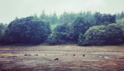
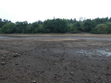
Notes: The Tottiford circle was discovered in 2009 when there was lower than usual levels of water in Tottiford reservoir; it featured as part of a Time Team dig in 2010. Normally it is submerged within the reservoir. During the drought of August 2022 the stones were exposed again for the first time for years. Photo by Zoe Lester taken on 04/09/22. Reproduced with kind permission - copyright remains with Zoe.
Nearby sites: SX 81095 83161
Distance: 2.09km
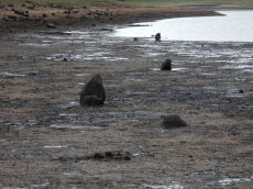
Tottiford Reservoir 1 Stone Row
OS Map: SX 81137 83093
HER: MDV102540
Megalithic Portal: 24205
The Stone Rows of GB: Tottiford Reservoir 1
PMD: Tottiford Reservoir Stone Rows
ShortName: SR Tottiford1
Notes: "This stone row was initially noticed in late 2009, when the reservoir was only 6% full. This double stone row is aligned roughly north-west - south-east and is at least 54 meters in length. The size and form of the stones used varies considerably but the two rows are consistently 1.2 meters apart. The row leads directly to (or away from) the naturally occurring mound south-east of the stone circle." This row will be normally covered by the Tottiford Reservoir. The stones of the row were exposed for a short period following the drought of August 2022. From the northenern end the author took a photo at SX 81135 83102 (6/9/22). It was too muddy to get any closer and the grid reference of SX 81137 83093 is inferred and used for this entry. Max Piper visited the day before and got as close as SX 81129 83102 which is consistent with the inferred actual location.
Nearby sites: SX 81137 83093
Distance: 2.16km
Tottiford Reservoir 2 Stone Row
OS Map: SX 81104 83202
HER: MDV102542
The Stone Rows of GB: Tottiford Reservoir 2
PMD: Tottiford Reservoir
Alternate name: Tottiford Reservoir II Stone Row
ShortName: SR Tottiford2
Notes: Excavated during the Time Team dig in 2011. This row will be normally covered by the Tottiford Reservoir. The stones of the row were exposed for a short period following the drought of August 2022. See Wessex Archaeology report Tottiford Reservoir: Archaeological Evaluation and Assessment of Results. See also Legendary Dartmoor - Time Team at Tottiford. The NGR used here is the eastern end from Max Piper (visit 05/09/22). Max recorded SX 81104 83202 for eastern end and SX 81077 83202 for western end. The author vistied on 06/09/22 and obtained SX 81117 83210 for the eastern end. The listing uses Max's NGR.
Nearby sites: SX 81104 83202
Distance: 2.05km
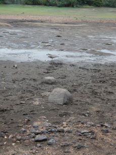
Tottiford Reservoir Mound Cairn
OS Map: SX 81121 83132
HER: MDV102544
ShortName: CN Tottiford
Notes: "A total of 156 pieces of worked flint were recovered from the excavation, with the majority of the material found consisting of debitage from flint working, most of which is small enough to qualify as chips. The small size of much of the material, the indications of blade and bladelet technology and one triangular platform rejuvenation flake, suggest a date in the (probably later) Meolithic for most of the material."
"A number of tools were recovered, including a neat end scraper of probable late Neolithic date, a notched flake of probable Meolithic date, an unstratified piercer and a crude end scraper from an unstratified location."
"The 2010 excavation of test pits on the mound confirmed the presence of worked flint and concluded the mound was a natural feature and also suggested that the presence of the flint could be the result of selective deposition by water originating upstream."
Nearby sites: SX 81121 83132
Distance: 2.12km