
Prehistoric sites within 2km of SX 67800 59100
Guidance for walkers: The monuments featured in this database are archaeological treasures and need to be protected and preserved - please do not disturb any sites. Please check access and firing times before visiting sites, not all sites listed are on open access land. Firing ranges and boundaries of open access areas are marked on the OL28 OS Dartmoor Explorer map. Please stick to the country code and consider giving support to the numerous agencies that help to keep Dartmoor a fabulous natural and historic environment!
About the database listings: In all listings clicking on the photo or the site name will open a page for the site with a larger photo and further details from the database. The database now has over 6680 records covering nearly all publicly listed sites on Dartmoor including around 4800 round houses. This level of detail is of interest to archaeologists but tends to swamp listings of sites more likely to be of interest for walkers. For this reason, the listings default to around 550 core sites only. These are the stone circles, stone rows and the ring cairns listed by Turner. The default search radius is 2 km. The controls below the map can be used to start a new search by entering a 6- or 8-digit reference (without the prefix "SX"). The search radius can be specified and you can add incremental Display layers of detail on top of the core sites. If using a more detailed layer you will need to decrease the search radius to avoid getting hundreds of search results.
- Core sites Default listing of core sites consisting of stone circles & rows and some of the major ring cairns.
- Plus cairns adds approx. 1000 cairns and other minor sites not included in the core listings but excluding round houses.
- Plus round houses adds approx. 4800 round houses.
- Plus non-sites adds in the records for sites that no longer exist or are not prehistoric sites.
- Plus duplicates adds records excluded as duplicates. Those maybe duplicate records in external listings (e.g. the Historic Environment Records). For example, some sites have been identified as cairns in some listings and interpreted as round houses in other listings and both records appear.
These listings have incorporated, matched up and merged all of the records from all of the major archaeological listings including: Worth, Grinsell, Turner, Butler, Bill Radcliffe, Sandy Gerrard, Megalithic Portal, the National Monument Records and the Historic Environment Records. The author would like to thank Bill, Sandy, the lovely people both at Megalithic Portal (especially Anne Tate who did an amazing job to link listings) and at ACE Archaeology for collaborative work over the years to synchronise and correct listings across the various websites which now interlink. A culmination of years of work the final merger of cairn records took 3 months of cross referencing in 2017 the result being a snapshot of the records at that time. This data has in turn been refined since by field work and research. The round house data was supplied by Sandy Gerrard. Grid references are in order of accuracy: from Google Earth satellite, if visible and found, from a Garmin GPS reading, if visited by the author and from the literature otherwise. Individual site pages will state the source of the grid reference and provide satellite imagery. If a site listing lacks a photo it has not yet been visited by the author in which case the grid reference is from the literature.
Currently the database only includes sites which can be represented by a grid reference. Reaves are not included as they require GIS shape technology which is beyond the current capability of this system. To see the sources for the records, look at the tables on the resources menu. The database listings can also be viewed on a Google map and downloaded as GPS datasets for Garmin devices.
Corrections, or any feedback or suggestions are very welcome, email: info@dartmoorwalks.org.uk.
NOTE: Clicking on the icons for each monument in the map will give the name of the site. You can zoom in and out and drag the map around.
List of sites within 2km of SX 67800 59100
Beacon Plain A Standing Stone
Prehistoric Dartmoor Walks: Dartmoor Walk: The Neolithic tombs of Cuckoo Ball & Corringdon Ball
OS Map: SX 65838 59189
HER: MDV2888
Megalithic Portal: 44532
The Stone Rows of GB: Butterdon East
PMD: Beacon Plain
ShortName: SS Beacon Pl A
Butler map: 53.8
Butler Vol 5: p.216 & Fig.150
DPD page: 79
Notes: "One of two large granite blocks situated some 500 meters east of Hangershell Rocks. May be fallen standing stones or stones brought to the site but never erected. This western stone lies 55 meters from the other and tapers towards its northern end. Between the two are traces of two other stones, and the fact that they form a straight line lends weight to the argument that they are fallen menhirs. This western stone was excavated in august 1968, and groups of small stones were found at the broad end and along the w side as if to receive the stone when it was erected." For more on that see coverage on the SRGB and on PMD. See also HER record MDV2883 and also Butterdon East Stone Row and Beacon Plain B Standing Stone.
Nearby sites: SX 65838 59189
Distance: 1.96km
Beacon Plain B Standing Stone
Prehistoric Dartmoor Walks: Dartmoor Walk: The Neolithic tombs of Cuckoo Ball & Corringdon Ball
OS Map: SX 65886 59210
HER: MDV2883
Megalithic Portal: 44532
The Stone Rows of GB: Butterdon East
PMD: Beacon Plain
ShortName: SS Beacon Pl B
Butler map: 53.8
Butler Vol 5: p.216 & Fig.150
DPD page: 79
Notes: "There are two possible menhirs, on Beacon Plain, 500 yards east of Hangershell Rock. The more easterly stone measures 18 feet 4 inches in length. The other stone lies 57 yards away on a bearing 26 degrees south of west. It is 18 feet in length, 5 feet 6 inches wide at one end, and tapers to a blunt point. The stones are completely isolated on a grass moor, and have none of the characteristics of surface boulders. If they were menhirs they are the largest known on Dartmoor." There are suggestions these two stones are ends of a short stone row with a smaller stone in between. For more on that see coverage on the SRGB and on PMD. See also HER record MDV2888 and also Butterdon East Stone Row and Beacon Plain A Standing Stone.
Nearby sites: SX 65886 59210
Distance: 1.92km
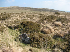
Butterdon East Stone Row
OS Map: SX 65870 59203
HER: MDV2888
The Stone Rows of GB: Butterdon East
PMD: Butterdon E. Stone Row
Alternate name: Butterdon E. Stone Row
ShortName: SR ButterdonE
Butler map: 53.8
Butler Vol 5: p.218 & Fig.150
Notes: There are two massive slabs with one small slab forming an alignment. It is unclear whether these were originally standing but it is thought they could have been placed in their current locations. This would make for a very spectacular stone row and one that would be quite unique on Dartmoor. However, there are stone rows consisting of two huge slabs and a small central slab in other parts of the country. The grid reference given here and the photo is of the central stone.
Nearby sites: SX 65870 59203
Distance: 1.93km
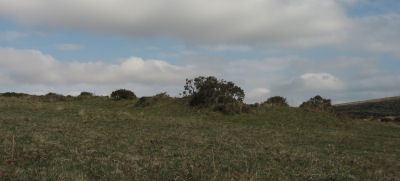
Butterdon Hill Chambered Tomb
Prehistoric Dartmoor Walks: Dartmoor Walk: The Neolithic tombs of Cuckoo Ball & Corringdon Ball
OS Map: SX 66012 58573
HER: MDV2886
Megalithic Portal: 31698
PMD: Butterdon Long Cairn
Alternate name: Butterdon Hill chambered cairn Chambered Tomb
ShortName: NT Butterdon
Butler map: 53.15
Butler Vol 5: p.155
Grinsell: A:UGB 2
Notes: "The mound is situated on a slight south-east slope at 1050 ft O.D. It is 25 metres long, orientated north-south, is 16.0 metres wide and 0.9 metre high at the north end and 10.0 metres wide and 0.7 metre high at the south end. There are no visible side ditches. The construction is of earth and small stones but extensive pillaging and/or excavation has exposed a number of large upright and some displaced stones. The mound is certainly a long barrow."
Nearby sites: SX 66012 58573
Distance: 1.86km
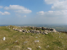
Eastern beacon (S) Platform Cairn Circle
OS Map: SX 66755 58770
HER: MDV3106
Megalithic Portal: 17583
Alternate name: Ugborough Beacon 4 Platform Cairn Circle
ShortName: PC Ugborough 4
Butler map: 53.16.6
Grinsell: UGB 20
Turner: E52
Barrow Report: 62
Notes: Flat top turf-covered cairn. 20.5m. diameter, 1.7m. high. Possible remains of retaining circle. Large hollow in centre
Nearby sites: SX 66755 58770
Distance: 1.10km

Lower Glasscombe Cist
Prehistoric Dartmoor Walks: Dartmoor Walk: The Neolithic tombs of Cuckoo Ball & Corringdon Ball
OS Map: SX 66506 60502
HER: MDV5652
Megalithic Portal: 45761
PMD: Lower Glasscombe
Alternate name: Glaze Meet Cist
ShortName: CT Lower Glass
Butler map: 56.3
DPD page: 81
Grinsell: UGB 11
Barrow Report: 72
Notes: "There is a very slight trace of a mound and scattered rocks indicate the remains of a cairn ... Only one sidestone and one endstone now remain with the coverstone lying 11 feet away to the south-east. Overall dimensions of the coverstone are 49 inches by 24 inches". Lethbridge Scad Brook cist p.81 Butler Glaze Meet - Vol. 4. Map 56.3 (diagram p.85).
Copyright for photos and plans from Barrow Reports 71-73 belong to the Dixon estate. Reproduced here with kind permission.
Nearby sites: SX 66506 60502
Distance: 1.91km
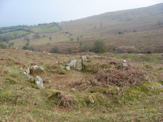
Scad Brook Enclosed Settlement
OS Map: SX 66681 59973
HER: MDV2913
Megalithic Portal: 45573
ShortName: ES Scad Brook
DPD page: 81
Notes: Sub-circular enclosure approximately 1.25 hectares in area containing eleven hut circles ranging from 3.5 metres to 10 metres in diameter, with entrances facing south-east and many of the walls standing up to a metre high. The most complete hut has been excavated and re-instated with walls faced with orthostats and an entrance with jambs. Lethbridge p.81
Nearby sites: SX 66681 59973
Distance: 1.42km
Yellowberries Copse Fort
Prehistoric Dartmoor Walks: Dartmoor Resource: Table of Devon Iron Age Forts
OS Map: SX 69217 58614
HER: MDV2925
ShortName: FT:Yellowberri
Nearby sites: SX 69217 58614
Distance: 1.50km