
Prehistoric sites within 2km of SX 62900 86800
Guidance for walkers: The monuments featured in this database are archaeological treasures and need to be protected and preserved - please do not disturb any sites. Please check access and firing times before visiting sites, not all sites listed are on open access land. Firing ranges and boundaries of open access areas are marked on the OL28 OS Dartmoor Explorer map. Please stick to the country code and consider giving support to the numerous agencies that help to keep Dartmoor a fabulous natural and historic environment!
About the database listings: In all listings clicking on the photo or the site name will open a page for the site with a larger photo and further details from the database. The database now has over 6680 records covering nearly all publicly listed sites on Dartmoor including around 4800 round houses. This level of detail is of interest to archaeologists but tends to swamp listings of sites more likely to be of interest for walkers. For this reason, the listings default to around 550 core sites only. These are the stone circles, stone rows and the ring cairns listed by Turner. The default search radius is 2 km. The controls below the map can be used to start a new search by entering a 6- or 8-digit reference (without the prefix "SX"). The search radius can be specified and you can add incremental Display layers of detail on top of the core sites. If using a more detailed layer you will need to decrease the search radius to avoid getting hundreds of search results.
- Core sites Default listing of core sites consisting of stone circles & rows and some of the major ring cairns.
- Plus cairns adds approx. 1000 cairns and other minor sites not included in the core listings but excluding round houses.
- Plus round houses adds approx. 4800 round houses.
- Plus non-sites adds in the records for sites that no longer exist or are not prehistoric sites.
- Plus duplicates adds records excluded as duplicates. Those maybe duplicate records in external listings (e.g. the Historic Environment Records). For example, some sites have been identified as cairns in some listings and interpreted as round houses in other listings and both records appear.
These listings have incorporated, matched up and merged all of the records from all of the major archaeological listings including: Worth, Grinsell, Turner, Butler, Bill Radcliffe, Sandy Gerrard, Megalithic Portal, the National Monument Records and the Historic Environment Records. The author would like to thank Bill, Sandy, the lovely people both at Megalithic Portal (especially Anne Tate who did an amazing job to link listings) and at ACE Archaeology for collaborative work over the years to synchronise and correct listings across the various websites which now interlink. A culmination of years of work the final merger of cairn records took 3 months of cross referencing in 2017 the result being a snapshot of the records at that time. This data has in turn been refined since by field work and research. The round house data was supplied by Sandy Gerrard. Grid references are in order of accuracy: from Google Earth satellite, if visible and found, from a Garmin GPS reading, if visited by the author and from the literature otherwise. Individual site pages will state the source of the grid reference and provide satellite imagery. If a site listing lacks a photo it has not yet been visited by the author in which case the grid reference is from the literature.
Currently the database only includes sites which can be represented by a grid reference. Reaves are not included as they require GIS shape technology which is beyond the current capability of this system. To see the sources for the records, look at the tables on the resources menu. The database listings can also be viewed on a Google map and downloaded as GPS datasets for Garmin devices.
Corrections, or any feedback or suggestions are very welcome, email: info@dartmoorwalks.org.uk.
NOTE: Clicking on the icons for each monument in the map will give the name of the site. You can zoom in and out and drag the map around.
List of sites within 2km of SX 62900 86800
Hangingstone Hill Cairn
OS Map: SX 61704 86136
HER: MDV4377
Megalithic Portal: 45858
Alternate name: Hangingstone Hill 1 Cairn
ShortName: CN:Hangingst 1
Butler map: 41.5
Grinsell: LYD 6
Notes: "A low, flat-topped cairn located on the summit of Hangingstone Hill. It measures 17.5m north to south by 15.0m at base and is maximum 1.4m high. It is apparently composed of medium sized granite slabs and boulders with a thin and patchy covering of turf. An ovoid hollow, 3.1m north to south by 2.0m and 0.3m deep, containing the stump of the flag pole (noted in the Devon SMR) lies slightly east of centre. A Range Wardens' hut encroaches on the southern side of the cairn. A considerable amount of peat has built up or has been deposited on the eastern side elongating the mound by some 10m in this direction." Partially excavated and repaired in 2016, see HER record. Butler Map 41.5 (Vol 2).
Nearby sites: SX 61704 86136
Distance: 1.37km
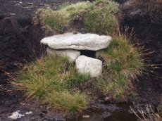
Shoveldown N.W. 1 Cist
Prehistoric Dartmoor Walks: Dartmoor Site: Shovel Down Ceremonial Complex
OS Map: SX 64389 86247
HER: MDV4394
Megalithic Portal: 45782
PMD: Stonetor Hill
Alternate name: Shoveldown N.W.1 Cist
ShortName: CT:ShovelNW 1
Butler map: 37.5.1
Butler Vol 5: p.202 & Fig.145
Grinsell: GID 1
Notes: NB. NGR from PMD is SX64398640. "The remains of a Bronze age cairn and cist which form part of a cairn cemetery on Long Ridge, known locally as Langridge, overlooking the valley of the River North Teign. The cairn has a circular mound which measures 5.2 metres in diameter and 0.5 metres high. The cist measures 0.83 metres square by up to 0.47 metres deep. The capstone, which once covered the cist, now lies 0.7 metres NNW of the cist." Butler Shoveldown N.W.1. - Vol. 2. Map 37.5. (diagram Vol. 5. p.202).
Nearby sites: SX 64389 86247
Distance: 1.59km
Whitehorse Hill Cist
OS Map: SX 61735 85482
HER: MDV66367
Megalithic Portal: 29778
PMD: White Horse Hill
ShortName: CT Whitehorse1
DPD page: 131
Notes: This cist was excavated in August 2011. It possibly featured on an 1892 map by John Chudleigh in An Exploration of Dartmoor's Antiquities. It was re-discovered in 1999 and recently excavated.
Nearby sites: SX 61735 85482
Distance: 1.76km