
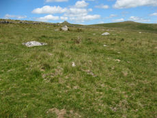
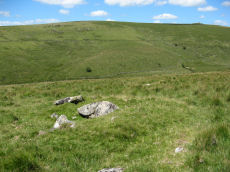
Prehistoric sites within 3km of SX 59750 75000
Guidance for walkers: The monuments featured in this database are archaeological treasures and need to be protected and preserved - please do not disturb any sites. Please check access and firing times before visiting sites, not all sites listed are on open access land. Firing ranges and boundaries of open access areas are marked on the OL28 OS Dartmoor Explorer map. Please stick to the country code and consider giving support to the numerous agencies that help to keep Dartmoor a fabulous natural and historic environment!
About the database listings: In all listings clicking on the photo or the site name will open a page for the site with a larger photo and further details from the database. The database now has over 6680 records covering nearly all publicly listed sites on Dartmoor including around 4800 round houses. This level of detail is of interest to archaeologists but tends to swamp listings of sites more likely to be of interest for walkers. For this reason, the listings default to around 550 core sites only. These are the stone circles, stone rows and the ring cairns listed by Turner. The default search radius is 2 km. The controls below the map can be used to start a new search by entering a 6- or 8-digit reference (without the prefix "SX"). The search radius can be specified and you can add incremental Display layers of detail on top of the core sites. If using a more detailed layer you will need to decrease the search radius to avoid getting hundreds of search results.
- Core sites Default listing of core sites consisting of stone circles & rows and some of the major ring cairns.
- Plus cairns adds approx. 1000 cairns and other minor sites not included in the core listings but excluding round houses.
- Plus round houses adds approx. 4800 round houses.
- Plus non-sites adds in the records for sites that no longer exist or are not prehistoric sites.
- Plus duplicates adds records excluded as duplicates. Those maybe duplicate records in external listings (e.g. the Historic Environment Records). For example, some sites have been identified as cairns in some listings and interpreted as round houses in other listings and both records appear.
These listings have incorporated, matched up and merged all of the records from all of the major archaeological listings including: Worth, Grinsell, Turner, Butler, Bill Radcliffe, Sandy Gerrard, Megalithic Portal, the National Monument Records and the Historic Environment Records. The author would like to thank Bill, Sandy, the lovely people both at Megalithic Portal (especially Anne Tate who did an amazing job to link listings) and at ACE Archaeology for collaborative work over the years to synchronise and correct listings across the various websites which now interlink. A culmination of years of work the final merger of cairn records took 3 months of cross referencing in 2017 the result being a snapshot of the records at that time. This data has in turn been refined since by field work and research. The round house data was supplied by Sandy Gerrard. Grid references are in order of accuracy: from Google Earth satellite, if visible and found, from a Garmin GPS reading, if visited by the author and from the literature otherwise. Individual site pages will state the source of the grid reference and provide satellite imagery. If a site listing lacks a photo it has not yet been visited by the author in which case the grid reference is from the literature.
Currently the database only includes sites which can be represented by a grid reference. Reaves are not included as they require GIS shape technology which is beyond the current capability of this system. To see the sources for the records, look at the tables on the resources menu. The database listings can also be viewed on a Google map and downloaded as GPS datasets for Garmin devices.
Corrections, or any feedback or suggestions are very welcome, email: info@dartmoorwalks.org.uk.
NOTE: Clicking on the icons for each monument in the map will give the name of the site. You can zoom in and out and drag the map around.
List of sites within 3km of SX 59750 75000
Blackbrook (Prowse) Reported Cist
OS Map: SX 6050 7384
HER: MDV6247
PMD: Blackabrook W.
ShortName: CT?Blackbroo3
Notes: Prowse, A. B., 1901, The Antiquities of Ockery and Roundhill. An imperfect ring of stones five yards in diameter, which must at some time have encircled a kisvaen. Doubtful!
Nearby sites: SX 6050 7384
Distance: 1.38km
Littaford Tor E Cist
OS Map: SX 61846 76717
HER: MDV-1
PMD: Littaford Tor E.
ShortName: CT Littaford2
Notes: Radcliffe: "Long axis approx W-E . Stones visible on N ,E and S sides and some stone could be felt under grass on W side. Approx. 1m x 0.5m x 0.5m depth internally. No obvious sign of cairn mound. No obvious stonecutting in vicinity. TAP Greeves (pers. comm.) "
Nearby sites: SX 61846 76717
Distance: 2.71km
Blakey Tor Cairn
OS Map: SX 6115 7373
HER: MDV18419
PMD: Blakey Tor
ShortName: CN:Blakey To1
Notes: Radcliffe, doubtful cist: Possibly the cairn referred to in an English Heritage Report and by Fletcher and Dunn in "Patterns of the Past", at SX 6115 7373, as a cairn having a "shallow depression in its top".
Nearby sites: SX 6115 7373
Distance: 1.89km
Walkhampton Common NE Round House
OS Map: SX 57672 73085
HER: MDV3692
ShortName: HT:Walkhampt1
Nearby sites: SX 57672 73085
Distance: 2.83km
Oakery Round House
OS Map: SX 5989 7406
HER: MDV4100
ShortName: HT:Oakery1
Nearby sites: SX 5989 7406
Distance: 0.95km
Walkhampton Common NE Round House
OS Map: SX 57782 73034
HER: MDV49785
ShortName: HT:Walkhampt2
Nearby sites: SX 57782 73034
Distance: 2.78km
Walkhampton Common NE Round House
OS Map: SX 57688 73086
HER: MDV3692
ShortName: HT:Walkhampt3
Nearby sites: SX 57688 73086
Distance: 2.81km
Walkhampton Common NE Round House
OS Map: SX 57693 73064
HER: MDV3692
ShortName: HT:Walkhampt4
Nearby sites: SX 57693 73064
Distance: 2.82km
Walkhampton Common NE Round House
OS Map: SX 5772 7303
HER: MDV3692
ShortName: HT:Walkhampt5
Nearby sites: SX 5772 7303
Distance: 2.83km
Walkhampton Common NE Round House
OS Map: SX 5773 7304
HER: MDV3692
ShortName: HT:Walkhampt6
Nearby sites: SX 5773 7304
Distance: 2.81km
Walkhampton Common NE Round House
OS Map: SX 57712 73073
HER: MDV3692
ShortName: HT:Walkhampt7
Nearby sites: SX 57712 73073
Distance: 2.80km
Oakery (SE of ) 1 Clearance Cairn
OS Map: SX 59754 74111
HER: MDV3792
ShortName: CNxOakery (S1
Grinsell: LYD 69
Notes: 6 post-medieval stone heaps
Nearby sites: SX 59754 74111
Distance: 0.89km
Walkhampton Common NE Round House
OS Map: SX 57771 73058
HER: MDV49786
ShortName: HT:Walkhampt8
Nearby sites: SX 57771 73058
Distance: 2.77km
Oakery (SE of ) 2 Clearance Cairn
OS Map: SX 59764 74105
HER: MDV3793
ShortName: CNxOakery (S2
Grinsell: LYD 70
Notes: 6 post-medieval stone heaps
Nearby sites: SX 59764 74105
Distance: 0.90km
Walkhampton Common NE Round House
OS Map: SX 57729 73073
HER: MDV3692
ShortName: HT:Walkhampt9
Nearby sites: SX 57729 73073
Distance: 2.79km
Oakery (SE of ) 3 Clearance Cairn
OS Map: SX 59767 74096
HER: MDV3794
ShortName: CNxOakery (S3
Grinsell: LYD 71
Notes: 6 post-medieval stone heaps
Nearby sites: SX 59767 74096
Distance: 0.90km
Walkhampton Common NE Round House
OS Map: SX 57695 73048
HER: MDV3692
ShortName: HT:Walkhampt10
Nearby sites: SX 57695 73048
Distance: 2.83km
Oakery (SE of ) 4 Clearance Cairn
OS Map: SX 59792 74070
HER: MDV3795
ShortName: CNxOakery (S4
Grinsell: LYD 72
Notes: 6 post-medieval stone heaps
Nearby sites: SX 59792 74070
Distance: 0.93km
Walkhampton Common NE Round House
OS Map: SX 57678 73081
HER: MDV3692
ShortName: HT:Walkhampt11
Nearby sites: SX 57678 73081
Distance: 2.82km
Oakery (SE of ) 5 Clearance Cairn
OS Map: SX 59797 74066
HER: MDV3796
ShortName: CNxOakery (S5
Grinsell: LYD 73
Notes: 6 post-medieval stone heaps
Nearby sites: SX 59797 74066
Distance: 0.94km
Walkhampton Common NE Round House
OS Map: SX 57686 73048
HER: MDV3692
ShortName: HT:Walkhampt12
Nearby sites: SX 57686 73048
Distance: 2.84km
Oakery (SE of ) 6 Clearance Cairn
OS Map: SX 59815 74055
HER: MDV3797
ShortName: CNxOakery (S6
Grinsell: LYD 74
Notes: 6 post-medieval stone heaps
Nearby sites: SX 59815 74055
Distance: 0.95km
Walkhampton Common NE Round House
OS Map: SX 57721 73062
HER: MDV3692
ShortName: HT:Walkhampt13
Nearby sites: SX 57721 73062
Distance: 2.81km
Walkhampton Common NE Round House
OS Map: SX 57707 73059
HER: MDV3692
ShortName: HT:Walkhampt14
Nearby sites: SX 57707 73059
Distance: 2.82km
Crockern Tor N.W.2 Cairn
OS Map: SX 61262 75987
HER: MDV52777
ShortName: CN Crockern 2
Nearby sites: SX 61262 75987
Distance: 1.81km
Littaford Tor 3 Cairn
OS Map: SX 61849 77048
HER: MDV52779
ShortName: CN Littaford3
Nearby sites: SX 61849 77048
Distance: 2.93km
Longaford Tor Round House
OS Map: SX 61334 77325
HER: MDV105675
ShortName: HT:Longafd1
Nearby sites: SX 61334 77325
Distance: 2.81km
Longaford Tor Round House
OS Map: SX 61329 77303
HER: MDV105675
ShortName: HT:Longafd2
Nearby sites: SX 61329 77303
Distance: 2.79km
Longaford Tor Round House
OS Map: SX 61322 76768
HER: MDV105675
ShortName: HT:Longafd3
Nearby sites: SX 61322 76768
Distance: 2.37km
Longaford Tor Round House
OS Map: SX 61401 76943
HER: MDV105675
ShortName: HT:Longafd4
Nearby sites: SX 61401 76943
Distance: 2.55km
Longaford Tor Round House
OS Map: SX 61329 77356
HER: MDV105675
ShortName: HT:Longafd7
Nearby sites: SX 61329 77356
Distance: 2.84km
Longaford Tor Round House
OS Map: SX 61328 77213
HER: MDV105675
ShortName: HT:Longafd8
Nearby sites: SX 61328 77213
Distance: 2.72km
Longaford Tor Round House
OS Map: SX 61329 77418
HER: MDV105675
ShortName: HT:Longafd9
Nearby sites: SX 61329 77418
Distance: 2.89km
Longaford Tor Round House
OS Map: SX 61324 77380
HER: MDV105675
ShortName: HT:Longafd10
Nearby sites: SX 61324 77380
Distance: 2.85km
Longaford Tor Round House
OS Map: SX 61306 76653
HER: MDV105675
ShortName: HT:Longafd11
Nearby sites: SX 61306 76653
Distance: 2.27km
Longaford Tor Round House
OS Map: SX 61305 76624
HER: MDV105675
ShortName: HT:Longafd12
Nearby sites: SX 61305 76624
Distance: 2.25km
Longaford Tor Round House
OS Map: SX 61328 77479
HER: MDV105675
ShortName: HT:Longafd13
Nearby sites: SX 61328 77479
Distance: 2.94km
Longaford Tor Round House
OS Map: SX 61324 77294
HER: MDV105675
ShortName: HT:Longafd14
Nearby sites: SX 61324 77294
Distance: 2.78km
Longaford Tor Round House
OS Map: SX 61329 77256
HER: MDV105675
ShortName: HT:Longafd15
Nearby sites: SX 61329 77256
Distance: 2.75km
Longaford Tor Round House
OS Map: SX 61324 77221
HER: MDV105675
ShortName: HT:Longafd16
Nearby sites: SX 61324 77221
Distance: 2.72km
Longaford Tor Round House
OS Map: SX 61384 76638
HER: MDV105675
ShortName: HT:Longafd17
Nearby sites: SX 61384 76638
Distance: 2.31km
Longaford Tor Round House
OS Map: SX 61329 77356
HER: MDV105675
ShortName: HT:Longafd18
Nearby sites: SX 61329 77356
Distance: 2.84km
Round Hill Summit 3 Reported Cist
OS Map: SX 6111 7447
HER: MDV6256
PMD: Round Hill NE.
ShortName: CT?Roundhill 3
Butler map: 65.1.3
Notes: Alledged cist and stone row asdescribed by Prowse 1901. No significant features can be identified in this area.
Nearby sites: SX 6111 7447
Distance: 1.46km
Longaford Tor Round House
OS Map: SX 61413 77184
HER: MDV105675
ShortName: HT:Longafd19
Nearby sites: SX 61413 77184
Distance: 2.75km
Round Hill S.1 Reported Cairn
OS Map: SX 6099 7415
HER: MDV6372
ShortName: CN?RoundhillS1
Butler map: 65.1.4
Grinsell: LYD 77
Nearby sites: SX 6099 7415
Distance: 1.50km
Longaford Tor Round House
OS Map: SX 61225 77540
HER: MDV105675
ShortName: HT:Longafd20
Nearby sites: SX 61225 77540
Distance: 2.94km
Longaford Tor Round House
OS Map: SX 61331 76910
HER: MDV105675
ShortName: HT:Longafd21
Nearby sites: SX 61331 76910
Distance: 2.48km
Longaford Tor Round House
OS Map: SX 6141 7707
HER: MDV105675
ShortName: HT:Longafd22
Nearby sites: SX 6141 7707
Distance: 2.65km
Longaford Tor Round House
OS Map: SX 61217 77571
HER: MDV105675
ShortName: HT:Longafd23
Nearby sites: SX 61217 77571
Distance: 2.96km
Cholake Head Cairn
OS Map: SX 61460 73070
HER: MDV6307
ShortName: CN:Cholake H1
Butler map: 65.2
Grinsell: LYD 87
Barrow Report: 27
Nearby sites: SX 61460 73070
Distance: 2.58km
Longaford Tor Round House
OS Map: SX 61323 77241
HER: MDV105675
ShortName: HT:Longafd24
Nearby sites: SX 61323 77241
Distance: 2.74km
Crock of Gold Round House
OS Map: SX 61406 73073
HER: MDV54419
ShortName: HT:Crock of 1
Nearby sites: SX 61406 73073
Distance: 2.54km
Crockern Tor S Round House
OS Map: SX 61159 75446
HER: MDV5970
ShortName: HT:Crockern 1
Nearby sites: SX 61159 75446
Distance: 1.48km
Longaford Tor Round House
OS Map: SX 61339 77278
HER: MDV105675
ShortName: HT:Longafd26
Nearby sites: SX 61339 77278
Distance: 2.78km
Crockern Tor W Round House
OS Map: SX 6121 7597
HER: MDV66152
ShortName: HT:Crockern 2
Nearby sites: SX 6121 7597
Distance: 1.75km
Longaford Tor Round House
OS Map: SX 6135 7652
HER: MDV105675
ShortName: HT:Longafd27
Nearby sites: SX 6135 7652
Distance: 2.21km
Round Hill S.E.4 Cairn Circle & Cist
OS Map: SX 6063 7396
HER: MDV6250
PMD: Roundhill Leat
ShortName: CN:RoundhilSE4
Butler map: 65.3.4
Grinsell: LYD 83
Notes: Prowse 1901. Cairn with retaining circle. Remnant of a small cairn enclosing portions of two kists side by side, level with the surface and nearly filled up with soil. Note - cists no longer visible.
Nearby sites: SX 6063 7396
Distance: 1.36km
Crockern Tor W Round House
OS Map: SX 6116 7596
HER: MDV66154
ShortName: HT:Crockern 3
Nearby sites: SX 6116 7596
Distance: 1.71km
Longaford Tor Round House
OS Map: SX 61353 76627
HER: MDV105675
ShortName: HT:Longafd28
Nearby sites: SX 61353 76627
Distance: 2.28km
Oakery Bridge E. (6) Clearance Cairn
OS Map: SX 597 740
HER: MDV-1
ShortName: CNxOakery Br1
Butler map: 65.3
Notes: LYD 69-74. Clearance cairns? See individua listings -this record is a duplicate in that it refers to all of them.
Nearby sites: SX 597 740
Distance: 1.00km
Crockern Tor W Round House
OS Map: SX 6120 7595
HER: MDV5949
ShortName: HT:Crockern 4
Nearby sites: SX 6120 7595
Distance: 1.73km
Longaford Tor Round House
OS Map: SX 61355 76652
HER: MDV105675
ShortName: HT:Longafd29
Nearby sites: SX 61355 76652
Distance: 2.30km
Crockern Tor W Round House
OS Map: SX 6117 7590
HER: MDV66155
ShortName: HT:Crockern 5
Nearby sites: SX 6117 7590
Distance: 1.68km
Longaford Tor Round House
OS Map: SX 61374 77302
HER: MDV105675
ShortName: HT:Longafd30
Nearby sites: SX 61374 77302
Distance: 2.82km
Crockern Tor W Round House
OS Map: SX 6116 7597
HER: MDV66153
ShortName: HT:Crockern 6
Nearby sites: SX 6116 7597
Distance: 1.71km
Longaford Tor Round House
OS Map: SX 61376 77276
HER: MDV105675
ShortName: HT:Longafd31
Nearby sites: SX 61376 77276
Distance: 2.80km
Longaford Tor Round House
OS Map: SX 61363 76729
HER: MDV105675
ShortName: HT:Longafd32
Nearby sites: SX 61363 76729
Distance: 2.36km
Longaford Tor Round House
OS Map: SX 61506 77081
HER: MDV105675
ShortName: HT:Longafd33
Nearby sites: SX 61506 77081
Distance: 2.72km
Longaford Tor Round House
OS Map: SX 61381 77324
HER: MDV105675
ShortName: HT:Longafd34
Nearby sites: SX 61381 77324
Distance: 2.84km
Longaford Tor Round House
OS Map: SX 61360 77106
HER: MDV105675
ShortName: HT:Longafd35
Nearby sites: SX 61360 77106
Distance: 2.65km
Longaford Tor Round House
OS Map: SX 61432 77026
HER: MDV105675
ShortName: HT:Longafd36
Nearby sites: SX 61432 77026
Distance: 2.63km
Longaford Tor Round House
OS Map: SX 61386 76942
HER: MDV105675
ShortName: HT:Longafd37
Nearby sites: SX 61386 76942
Distance: 2.54km
Longaford Tor Round House
OS Map: SX 61397 77281
HER: MDV105675
ShortName: HT:Longafd38
Nearby sites: SX 61397 77281
Distance: 2.81km
Longaford Tor Round House
OS Map: SX 61417 77076
HER: MDV105675
ShortName: HT:Longafd39
Nearby sites: SX 61417 77076
Distance: 2.66km
Longaford Tor Round House
OS Map: SX 61382 76650
HER: MDV105675
ShortName: HT:Longafd40
Nearby sites: SX 61382 76650
Distance: 2.32km
Longaford Tor Round House
OS Map: SX 61382 76660
HER: MDV105675
ShortName: HT:Longafd41
Nearby sites: SX 61382 76660
Distance: 2.33km
Longaford Tor Round House
OS Map: SX 61394 77059
HER: MDV105675
ShortName: HT:Longafd42
Nearby sites: SX 61394 77059
Distance: 2.63km
Longaford Tor Round House
OS Map: SX 61379 77300
HER: MDV105675
ShortName: HT:Longafd43
Nearby sites: SX 61379 77300
Distance: 2.82km
North Hessary Tor 1 Cairn
OS Map: SX 57877 74224
HER: MDV5015
ShortName: CN:North Hes1
Butler map: 44.9.1
Grinsell: WAL 8
Nearby sites: SX 57877 74224
Distance: 2.03km
North Hessary Tor 2 Reported Cairn
OS Map: SX 5778 7432
ShortName: CN?North Hes2
Butler map: 44.9.2
Notes: Butler: "A more likely xample of a burial cairn lies about 100m downhill [from the North Hessary Tor summit cairn] to the north, a very disurbed mound beside the road ". No entry in NMR or HER.
Nearby sites: SX 5778 7432
Distance: 2.08km
North Hessary Tor 3 Reported Cist
OS Map: SX 578 742
PMD: Hessary Tor
ShortName: CT?North Hes3
Butler map: 44.9.3
Grinsell: B:WAL 36
Notes: Dilapidated cairn 'remarkable for beign double kisted' (Bate 1871). Grinsell doubtful site. Could be HER 5015, see also WAL 8. Butler suggests that Bate was possibly referring to the rather confused structure of the Yellowmead cist well down the western slopes (Butler Vol 3 p.33).
Nearby sites: SX 578 742
Distance: 2.11km
Longaford Tor Round House
OS Map: SX 6132 7653
HER: MDV105675
ShortName: HT:Longafd46
Nearby sites: SX 6132 7653
Distance: 2.19km
Longaford Tor Round House
OS Map: SX 61344 77362
HER: MDV105675
ShortName: HT:Longafd47
Nearby sites: SX 61344 77362
Distance: 2.85km
Longaford Tor Round House
OS Map: SX 61351 77489
HER: MDV105675
ShortName: HT:Longafd48
Nearby sites: SX 61351 77489
Distance: 2.96km
Longaford Tor Round House
OS Map: SX 61337 76927
HER: MDV105675
ShortName: HT:Longafd49
Nearby sites: SX 61337 76927
Distance: 2.50km
Longaford Tor Round House
OS Map: SX 61334 76787
HER: MDV105675
ShortName: HT:Longafd50
Nearby sites: SX 61334 76787
Distance: 2.39km
Longaford Tor Round House
OS Map: SX 61335 76790
HER: MDV105675
ShortName: HT:Longafd51
Nearby sites: SX 61335 76790
Distance: 2.39km
Longaford Tor Round House
OS Map: SX 61358 76930
HER: MDV105675
ShortName: HT:Longafd52
Nearby sites: SX 61358 76930
Distance: 2.51km
Longaford Tor Round House
OS Map: SX 6133 7655
HER: MDV105675
ShortName: HT:Longafd53
Nearby sites: SX 6133 7655
Distance: 2.21km
Longaford Tor Round House
OS Map: SX 61339 76625
HER: MDV105675
ShortName: HT:Longafd55
Nearby sites: SX 61339 76625
Distance: 2.27km
Longaford Tor Round House
OS Map: SX 61251 77510
HER: MDV105675
ShortName: HT:Longafd56
Nearby sites: SX 61251 77510
Distance: 2.92km
Longaford Tor Round House
OS Map: SX 61305 77525
HER: MDV105675
ShortName: HT:Longafd58
Nearby sites: SX 61305 77525
Distance: 2.97km
Longaford Tor Round House
OS Map: SX 61346 76749
HER: MDV105675
ShortName: HT:Longafd59
Nearby sites: SX 61346 76749
Distance: 2.37km
Longaford Tor Round House
OS Map: SX 61347 76621
HER: MDV105675
ShortName: HT:Longafd61
Nearby sites: SX 61347 76621
Distance: 2.28km
Longaford Tor Round House
OS Map: SX 61349 77259
HER: MDV105675
ShortName: HT:Longafd62
Nearby sites: SX 61349 77259
Distance: 2.77km
Longaford Tor Round House
OS Map: SX 6127 7750
HER: MDV105675
ShortName: HT:Longafd63
Nearby sites: SX 6127 7750
Distance: 2.93km
Longaford Tor Round House
OS Map: SX 61307 77333
HER: MDV105675
ShortName: HT:Longafd64
Nearby sites: SX 61307 77333
Distance: 2.80km
Longaford Tor Round House
OS Map: SX 61305 77439
HER: MDV105675
ShortName: HT:Longafd65
Nearby sites: SX 61305 77439
Distance: 2.89km
Longaford Tor Round House
OS Map: SX 6129 7689
HER: MDV105675
ShortName: HT:Longafd66
Nearby sites: SX 6129 7689
Distance: 2.44km
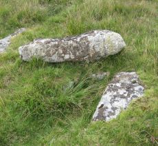
Littaford Tor Reported Cairn
OS Map: SX 61430 76490
HER: MDV52778
ShortName: CN Littaford1
Butler map: 29.1
Notes: A large granite slab lies the W side and a boulder is exposed just N of the centre. These may be part of a distroyed cist, but the boulder is very irregular and looks like a natural stone in situ around which the cairn may have been built.
Nearby sites: SX 61430 76490
Distance: 2.25km
Longaford Tor Round House
OS Map: SX 61302 76664
HER: MDV105675
ShortName: HT:Longafd68
Nearby sites: SX 61302 76664
Distance: 2.28km
Longaford Tor Round House
OS Map: SX 61234 77565
HER: MDV105675
ShortName: HT:Longafd69
Nearby sites: SX 61234 77565
Distance: 2.96km
Longaford Tor Round House
OS Map: SX 61259 77537
HER: MDV105675
ShortName: HT:Longafd70
Nearby sites: SX 61259 77537
Distance: 2.95km
Longaford Tor Round House
OS Map: SX 61259 77517
HER: MDV105675
ShortName: HT:Longafd71
Nearby sites: SX 61259 77517
Distance: 2.93km
Longaford Tor Round House
OS Map: SX 6126 7742
HER: MDV105675
ShortName: HT:Longafd72
Nearby sites: SX 6126 7742
Distance: 2.85km
Longaford Tor Round House
OS Map: SX 61294 77137
HER: MDV105675
ShortName: HT:Longafd73
Nearby sites: SX 61294 77137
Distance: 2.64km
Longaford Tor Round House
OS Map: SX 61255 77431
HER: MDV105675
ShortName: HT:Longafd74
Nearby sites: SX 61255 77431
Distance: 2.86km
Longaford Tor Round House
OS Map: SX 61242 77585
HER: MDV105675
ShortName: HT:Longafd75
Nearby sites: SX 61242 77585
Distance: 2.98km
Longaford Tor Round House
OS Map: SX 6129 7692
HER: MDV105675
ShortName: HT:Longafd76
Nearby sites: SX 6129 7692
Distance: 2.46km
Longaford Tor Round House
OS Map: SX 61270 77501
HER: MDV105675
ShortName: HT:Longafd77
Nearby sites: SX 61270 77501
Distance: 2.93km
Longaford Tor Round House
OS Map: SX 61238 77513
HER: MDV105675
ShortName: HT:Longafd78
Nearby sites: SX 61238 77513
Distance: 2.92km
Longaford Tor Round House
OS Map: SX 61283 77519
HER: MDV105675
ShortName: HT:Longafd79
Nearby sites: SX 61283 77519
Distance: 2.95km
Longaford Tor Round House
OS Map: SX 61285 77516
HER: MDV105675
ShortName: HT:Longafd80
Nearby sites: SX 61285 77516
Distance: 2.95km
Longaford Tor Round House
OS Map: SX 61287 77464
HER: MDV105675
ShortName: HT:Longafd81
Nearby sites: SX 61287 77464
Distance: 2.90km
Longaford Tor Round House
OS Map: SX 61299 77396
HER: MDV105675
ShortName: HT:Longafd82
Nearby sites: SX 61299 77396
Distance: 2.85km
Longaford Tor Round House
OS Map: SX 61301 77517
HER: MDV105675
ShortName: HT:Longafd84
Nearby sites: SX 61301 77517
Distance: 2.96km
Longaford Tor Round House
OS Map: SX 61290 77461
HER: MDV105675
ShortName: HT:Longafd86
Nearby sites: SX 61290 77461
Distance: 2.90km
Longaford Tor Round House
OS Map: SX 61260 77421
HER: MDV105675
ShortName: HT:Longafd87
Nearby sites: SX 61260 77421
Distance: 2.85km
Longaford Tor Round House
OS Map: SX 61256 77553
HER: MDV105675
ShortName: HT:Longafd89
Nearby sites: SX 61256 77553
Distance: 2.96km
Cholake Round House
OS Map: SX 6170 7352
HER: MDV18418
ShortName: HT:Cholake1
Nearby sites: SX 6170 7352
Distance: 2.45km
Longaford Tor Round House
OS Map: SX 61304 76822
HER: MDV105675
ShortName: HT:Longafd91
Nearby sites: SX 61304 76822
Distance: 2.39km
Longaford Tor Round House
OS Map: SX 61319 77460
HER: MDV105675
ShortName: HT:Longafd92
Nearby sites: SX 61319 77460
Distance: 2.92km
Longaford Tor Round House
OS Map: SX 6125 7751
HER: MDV105675
ShortName: HT:Longafd93
Nearby sites: SX 6125 7751
Distance: 2.92km
Longaford Tor Round House
OS Map: SX 61305 76812
HER: MDV105675
ShortName: HT:Longafd94
Nearby sites: SX 61305 76812
Distance: 2.39km
Longaford Tor Round House
OS Map: SX 6125 7751
HER: MDV105675
ShortName: HT:Longafd95
Nearby sites: SX 6125 7751
Distance: 2.92km
Longaford Tor Round House
OS Map: SX 61315 77465
HER: MDV105675
ShortName: HT:Longafd96
Nearby sites: SX 61315 77465
Distance: 2.92km
Longaford Tor Round House
OS Map: SX 61245 77450
HER: MDV105675
ShortName: HT:Longafd98
Nearby sites: SX 61245 77450
Distance: 2.87km
Round Hill (LYD 79a) Clearance Cairn
OS Map: SX 6123 7440
HER: MDV6219
ShortName: CN?Round79a
Grinsell: B:LYD 79a
Notes: Ditched mounds believed to be pillow mounds of rabbit warren c 18/19. See also duplicate HER record 54366.
Nearby sites: SX 6123 7440
Distance: 1.60km
Round Hill (LYD 79b) Clearance Cairn
OS Map: SX 6155 7421
HER: MDV6239
ShortName: CN?Round79b
Grinsell: B:LYD 79b
Notes: Ditched mounds believed to be pillow mounds of rabbit warren c 18/19
Nearby sites: SX 6155 7421
Distance: 1.97km
Round Hill (LYD 79c) Clearance Cairn
OS Map: SX 6171 7420
HER: MDV6240
ShortName: CN?Round79c
Grinsell: B:LYD 79c
Notes: Ditched mounds believed to be pillow mounds of rabbit warren c 18/19
Nearby sites: SX 6171 7420
Distance: 2.12km
Devil's Elbow (S of) Reported Cairn
OS Map: SX 5808 7264
HER: MDV61719
ShortName: CN?DevilsElbow
Grinsell: B:WAL 10a
Notes: Rowe's 'cairn containing a dilapidated kistvaen', considered natural.
Nearby sites: SX 5808 7264
Distance: 2.89km
Round Hill E. Reported Cairn
OS Map: SX 617 742
HER: MDV6240
ShortName: CNxRoundhil1 E
Nearby sites: SX 617 742
Distance: 2.11km
Blackbrook 1 Reported Cairn
OS Map: SX 6023 7387
HER: MDV6288
ShortName: CN:Blackbroo1
Notes: In area of tin working.
Nearby sites: SX 6023 7387
Distance: 1.23km
Blackbrook 2 Reported Cairn
OS Map: SX 6006 7392
HER: MDV6289
ShortName: CNxBlackbroo2
Grinsell: B:LYD 80a
Notes: Remains of a small tumulus (prowse). There is no evidence of a cairn in this area.
Nearby sites: SX 6006 7392
Distance: 1.12km
S of Devil's Elbow Reported Cairn
OS Map: SX 5808 7264
HER: MDV61719
ShortName: CT?S of Devi1
Notes: Possible cist; unconfirmed site. Source HER. Probably duplicate of CairnID 286 WAL 10
Nearby sites: SX 5808 7264
Distance: 2.89km
Hart Tor N Round House
OS Map: SX 58273 72493
HER: MDV3791
ShortName: HT:Hart Tor 1
Nearby sites: SX 58273 72493
Distance: 2.91km
Hart Tor N Round House
OS Map: SX 58260 72458
HER: MDV3791
ShortName: HT:Hart Tor 2
Nearby sites: SX 58260 72458
Distance: 2.95km
Hart Tor N Round House
OS Map: SX 58131 72620
HER: MDV3791
ShortName: HT:Hart Tor 3
Nearby sites: SX 58131 72620
Distance: 2.88km
Muddilake Round House
OS Map: SX 62621 75104
HER: MDV28590
ShortName: HT:Muddilake1
Nearby sites: SX 62621 75104
Distance: 2.87km
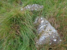
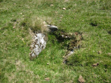
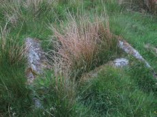
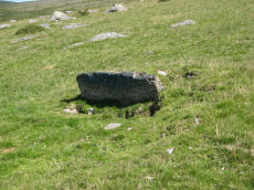
Bachelor's Hall Reported Cist
OS Map: SX 60426 73665
HER: MDV18392
PMD: Bull Park
ShortName: CT-Bachelor'1
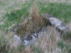
Notes: Greeves cairn and cist. Supposed cairn & cist poss natural feature. As can be seen in the photo this looks more like a natural feature.
Nearby sites: SX 60426 73665
Distance: 1.50km
Hart Tor N Round House
OS Map: SX 58133 72522
HER: MDV3791
ShortName: HT:Hart Tor 5
Nearby sites: SX 58133 72522
Distance: 2.96km
Hart Tor N Round House
OS Map: SX 58255 72505
HER: MDV3791
ShortName: HT:Hart Tor 6
Nearby sites: SX 58255 72505
Distance: 2.91km
Muddilake Round House
OS Map: SX 62716 75279
HER: MDV28590
ShortName: HT:Muddilake4
Nearby sites: SX 62716 75279
Distance: 2.98km
Hart Tor N Round House
OS Map: SX 58137 72611
HER: MDV3791
ShortName: HT:Hart Tor 7
Nearby sites: SX 58137 72611
Distance: 2.88km
Hart Tor N Round House
OS Map: SX 58244 72416
HER: MDV3791
ShortName: HT:Hart Tor 8
Nearby sites: SX 58244 72416
Distance: 2.99km
Hart Tor N Round House
OS Map: SX 58185 72584
HER: MDV3791
ShortName: HT:Hart Tor 9
Nearby sites: SX 58185 72584
Distance: 2.88km
Muddilake Round House
OS Map: SX 62648 75194
HER: MDV28590
ShortName: HT:Muddilake7
Nearby sites: SX 62648 75194
Distance: 2.90km
Hart Tor N Round House
OS Map: SX 5818 7252
HER: MDV3791
ShortName: HT:Hart Tor 10
Nearby sites: SX 5818 7252
Distance: 2.94km
Hart Tor N Round House
OS Map: SX 58234 72477
HER: MDV3791
ShortName: HT:Hart Tor 14
Nearby sites: SX 58234 72477
Distance: 2.94km
Hart Tor N Round House
OS Map: SX 58283 72436
HER: MDV3791
ShortName: HT:Hart Tor 15
Nearby sites: SX 58283 72436
Distance: 2.95km
Hart Tor N Round House
OS Map: SX 58134 72494
HER: MDV3791
ShortName: HT:Hart Tor 16
Nearby sites: SX 58134 72494
Distance: 2.98km
Hart Tor N Round House
OS Map: SX 58175 72466
HER: MDV3791
ShortName: HT:Hart Tor 17
Nearby sites: SX 58175 72466
Distance: 2.98km
Hart Tor N Round House
OS Map: SX 58172 72596
HER: MDV3791
ShortName: HT:Hart Tor 19
Nearby sites: SX 58172 72596
Distance: 2.88km
Hart Tor N Round House
OS Map: SX 58169 72539
HER: MDV3791
ShortName: HT:Hart Tor 20
Nearby sites: SX 58169 72539
Distance: 2.93km
Hart Tor N Round House
OS Map: SX 58168 72621
HER: MDV3791
ShortName: HT:Hart Tor 21
Nearby sites: SX 58168 72621
Distance: 2.86km
Hart Tor N Round House
OS Map: SX 58180 72549
HER: MDV3791
ShortName: HT:Hart Tor 25
Nearby sites: SX 58180 72549
Distance: 2.91km
Hart Tor N Round House
OS Map: SX 58082 72512
HER: MDV3791
ShortName: HT:Hart Tor 27
Nearby sites: SX 58082 72512
Distance: 3.00km
Hart Tor N Round House
OS Map: SX 58205 72440
HER: MDV3791
ShortName: HT:Hart Tor 28
Nearby sites: SX 58205 72440
Distance: 2.99km
Roundhill Round House
OS Map: SX 61592 74206
HER: MDV6241
ShortName: HT:Roundhill1
Nearby sites: SX 61592 74206
Distance: 2.01km
Roundhill Round House
OS Map: SX 61235 74403
HER: MDV6221
ShortName: HT:Roundhill2
Nearby sites: SX 61235 74403
Distance: 1.60km
Hart Tor N Round House
OS Map: SX 58253 72485
HER: MDV3791
ShortName: HT:Hart Tor 30
Nearby sites: SX 58253 72485
Distance: 2.93km
Roundhill Round House
OS Map: SX 61600 74313
HER: MDV54380
ShortName: HT:Roundhill3
Nearby sites: SX 61600 74313
Distance: 1.97km
Round Hill Summit 4 (site of) Reported Cist
OS Map: SX 61046 74422
HER: MDV6238
PMD: Blackabrook (Possible Stone Row)
ShortName: CT?Roundhill 4
Notes: Duplicate of HER 6256? Cist noted (prowse). Vis=not visible on raf photos (rchm app 1985). Vis=2/9/1950 (os) no trace of this feature found.
Nearby sites: SX 61046 74422
Distance: 1.42km
Hart Tor N Round House
OS Map: SX 58207 72526
HER: MDV3791
ShortName: HT:Hart Tor 31
Nearby sites: SX 58207 72526
Distance: 2.92km
Roundhill Round House
OS Map: SX 6118 7436
HER: MDV6221
ShortName: HT:Roundhill4
Nearby sites: SX 6118 7436
Distance: 1.57km
Roundhill Round House
OS Map: SX 61596 74218
HER: MDV6243
ShortName: HT:Roundhill5
Nearby sites: SX 61596 74218
Distance: 2.00km
Roundhill Round House
OS Map: SX 61395 74181
HER: MDV6235
ShortName: HT:Roundhill6
Nearby sites: SX 61395 74181
Distance: 1.84km
Hart Tor N Round House
OS Map: SX 58101 72517
HER: MDV3791
ShortName: HT:Hart Tor 34
Nearby sites: SX 58101 72517
Distance: 2.98km
Roundhill Round House
OS Map: SX 61257 74342
HER: MDV6221
ShortName: HT:Roundhill7
Nearby sites: SX 61257 74342
Distance: 1.64km
Beardown Hill N Round House
OS Map: SX 61073 76387
HER: MDV5897
ShortName: HT:Beardown 1
Nearby sites: SX 61073 76387
Distance: 1.92km
Roundhill Round House
OS Map: SX 61252 74354
HER: MDV6221
ShortName: HT:Roundhill8
Nearby sites: SX 61252 74354
Distance: 1.64km
Beardown Hill N Round House
OS Map: SX 61105 76434
HER: MDV5897
ShortName: HT:Beardown 2
Nearby sites: SX 61105 76434
Distance: 1.97km
Roundhill Round House
OS Map: SX 61325 74260
HER: MDV6221
ShortName: HT:Roundhill9
Nearby sites: SX 61325 74260
Distance: 1.74km
Beardown Hill N Round House
OS Map: SX 61088 76414
HER: MDV5897
ShortName: HT:Beardown 3
Nearby sites: SX 61088 76414
Distance: 1.95km
Roundhill Round House
OS Map: SX 6143 7408
HER: MDV54377
ShortName: HT:Roundhill10
Nearby sites: SX 6143 7408
Distance: 1.92km
Beardown Hill N Round House
OS Map: SX 61082 76452
HER: MDV5897
ShortName: HT:Beardown 4
Nearby sites: SX 61082 76452
Distance: 1.97km
Roundhill Round House
OS Map: SX 61357 74303
HER: MDV6221
ShortName: HT:Roundhill11
Nearby sites: SX 61357 74303
Distance: 1.75km
Beardown Hill N Round House
OS Map: SX 61050 76458
HER: MDV5897
ShortName: HT:Beardown 5
Nearby sites: SX 61050 76458
Distance: 1.95km
Roundhill Round House
OS Map: SX 61259 74233
HER: MDV6221
ShortName: HT:Roundhill12
Nearby sites: SX 61259 74233
Distance: 1.69km
Beardown Hill N Round House
OS Map: SX 6109 7666
HER: MDV27240
ShortName: HT:Beardown 6
Nearby sites: SX 6109 7666
Distance: 2.13km
Hart Tor N Round House
OS Map: SX 58187 72457
HER: MDV3791
ShortName: HT:Hart Tor 40
Nearby sites: SX 58187 72457
Distance: 2.98km
Roundhill Round House
OS Map: SX 6164 7393
HER: MDV18233
ShortName: HT:Roundhill13
Nearby sites: SX 6164 7393
Distance: 2.17km
Beardown Hill S Round House
OS Map: SX 60906 75934
HER: MDV5898
ShortName: HT:Beardown 7
Nearby sites: SX 60906 75934
Distance: 1.49km
Hart Tor N Round House
OS Map: SX 58296 72396
HER: MDV50262
ShortName: HT:Hart Tor 41
Nearby sites: SX 58296 72396
Distance: 2.98km
Roundhill Round House
OS Map: SX 61638 74214
HER: MDV54378
ShortName: HT:Roundhill14
Nearby sites: SX 61638 74214
Distance: 2.05km
Beardown Hill S Round House
OS Map: SX 60856 75896
HER: MDV5898
ShortName: HT:Beardown 8
Nearby sites: SX 60856 75896
Distance: 1.42km
Hart Tor N Round House
OS Map: SX 58187 72558
HER: MDV3791
ShortName: HT:Hart Tor 42
Nearby sites: SX 58187 72558
Distance: 2.90km
Roundhill Round House
OS Map: SX 61636 74257
HER: MDV54379
ShortName: HT:Roundhill15
Nearby sites: SX 61636 74257
Distance: 2.03km
Beardown Hill S Round House
OS Map: SX 60831 75890
HER: MDV5898
ShortName: HT:Beardown 9
Nearby sites: SX 60831 75890
Distance: 1.40km
Hart Tor N Round House
OS Map: SX 58115 72634
HER: MDV3791
ShortName: HT:Hart Tor 43
Nearby sites: SX 58115 72634
Distance: 2.88km
Roundhill Round House
OS Map: SX 61610 74218
ShortName: HT:Roundhill16
Nearby sites: SX 61610 74218
Distance: 2.02km
Beardown Hill S Round House
OS Map: SX 60834 75925
HER: MDV5898
ShortName: HT:Beardown 10
Nearby sites: SX 60834 75925
Distance: 1.43km
Roundhill Round House
OS Map: SX 61677 74192
HER: MDV54382
ShortName: HT:Roundhill17
Nearby sites: SX 61677 74192
Distance: 2.09km
Beardown Hill S Round House
OS Map: SX 60845 75920
HER: MDV5898
ShortName: HT:Beardown 11
Nearby sites: SX 60845 75920
Distance: 1.43km
Hart Tor N Round House
OS Map: SX 58226 72429
HER: MDV3791
ShortName: HT:Hart Tor 45
Nearby sites: SX 58226 72429
Distance: 2.99km
Roundhill Round House
OS Map: SX 61349 74237
HER: MDV6221
ShortName: HT:Roundhill18
Nearby sites: SX 61349 74237
Distance: 1.77km
Beardown Hill S Round House
OS Map: SX 60871 75902
HER: MDV5898
ShortName: HT:Beardown 12
Nearby sites: SX 60871 75902
Distance: 1.44km
Hart Tor N Round House
OS Map: SX 58228 72548
HER: MDV3791
ShortName: HT:Hart Tor 46
Nearby sites: SX 58228 72548
Distance: 2.89km
Roundhill Round House
OS Map: SX 61298 74268
HER: MDV6221
ShortName: HT:Roundhill19
Nearby sites: SX 61298 74268
Distance: 1.71km
Beardown Hill S Round House
OS Map: SX 60917 75960
HER: MDV5898
ShortName: HT:Beardown 13
Nearby sites: SX 60917 75960
Distance: 1.51km
Roundhill Round House
OS Map: SX 61312 74279
HER: MDV6221
ShortName: HT:Roundhill20
Nearby sites: SX 61312 74279
Distance: 1.72km
Beardown Hill S Round House
OS Map: SX 60922 75978
HER: MDV5898
ShortName: HT:Beardown 14
Nearby sites: SX 60922 75978
Distance: 1.53km
Roundhill Round House
OS Map: SX 61352 74244
HER: MDV6221
ShortName: HT:Roundhill21
Nearby sites: SX 61352 74244
Distance: 1.77km
Beardown Tors E Round House
OS Map: SX 61007 77651
HER: MDV5851
ShortName: HT:Beardown 15
Nearby sites: SX 61007 77651
Distance: 2.93km
Roundhill Round House
OS Map: SX 61276 74250
HER: MDV6221
ShortName: HT:Roundhill22
Nearby sites: SX 61276 74250
Distance: 1.70km
Beardown Tors E Round House
OS Map: SX 60998 77647
HER: MDV5851
ShortName: HT:Beardown 16
Nearby sites: SX 60998 77647
Distance: 2.93km
Hart Tor N Round House
OS Map: SX 58193 72572
HER: MDV3791
ShortName: HT:Hart Tor 50
Nearby sites: SX 58193 72572
Distance: 2.88km
Roundhill Round House
OS Map: SX 61323 74247
HER: MDV6221
ShortName: HT:Roundhill23
Nearby sites: SX 61323 74247
Distance: 1.74km
Beardown Tors E Round House
OS Map: SX 61006 77581
HER: MDV5851
ShortName: HT:Beardown 17
Nearby sites: SX 61006 77581
Distance: 2.87km
Roundhill Round House
OS Map: SX 6161 7441
HER: MDV18229
ShortName: HT:Roundhill24
Nearby sites: SX 6161 7441
Distance: 1.95km
Beardown Tors E Round House
OS Map: SX 61035 77587
HER: MDV5851
ShortName: HT:Beardown 18
Nearby sites: SX 61035 77587
Distance: 2.89km
Roundhill Round House
OS Map: SX 61330 74221
HER: MDV6221
ShortName: HT:Roundhill25
Nearby sites: SX 61330 74221
Distance: 1.76km
Beardown Tors E Round House
OS Map: SX 60983 77645
HER: MDV5851
ShortName: HT:Beardown 19
Nearby sites: SX 60983 77645
Distance: 2.92km
Roundhill Round House
OS Map: SX 61348 74249
HER: MDV6221
ShortName: HT:Roundhill26
Nearby sites: SX 61348 74249
Distance: 1.77km
Beardown Tors E Round House
OS Map: SX 61012 77603
HER: MDV5851
ShortName: HT:Beardown 20
Nearby sites: SX 61012 77603
Distance: 2.89km
Roundhill Round House
OS Map: SX 61336 74306
HER: MDV6221
ShortName: HT:Roundhill27
Nearby sites: SX 61336 74306
Distance: 1.73km
Beardown Tors E Round House
OS Map: SX 610 776
HER: MDV5851
ShortName: HT:Beardown 21
Nearby sites: SX 610 776
Distance: 2.88km
Roundhill Round House
OS Map: SX 61352 74240
HER: MDV6221
ShortName: HT:Roundhill28
Nearby sites: SX 61352 74240
Distance: 1.77km
Beardown Tors E Round House
OS Map: SX 61026 77556
HER: MDV5851
ShortName: HT:Beardown 22
Nearby sites: SX 61026 77556
Distance: 2.86km
Roundhill Round House
OS Map: SX 61335 74214
HER: MDV6221
ShortName: HT:Roundhill29
Nearby sites: SX 61335 74214
Distance: 1.77km
Roundhill Round House
OS Map: SX 61258 74359
HER: MDV6221
ShortName: HT:Roundhill30
Nearby sites: SX 61258 74359
Distance: 1.64km
Roundhill Round House
OS Map: SX 61259 74364
HER: MDV6221
ShortName: HT:Roundhill31
Nearby sites: SX 61259 74364
Distance: 1.64km
Roundhill Round House
OS Map: SX 61261 74243
HER: MDV6221
ShortName: HT:Roundhill32
Nearby sites: SX 61261 74243
Distance: 1.69km
Roundhill Round House
OS Map: SX 61288 74315
HER: MDV6221
ShortName: HT:Roundhill33
Nearby sites: SX 61288 74315
Distance: 1.68km
Roundhill Round House
OS Map: SX 61267 74276
HER: MDV6221
ShortName: HT:Roundhill34
Nearby sites: SX 61267 74276
Distance: 1.68km
Beardown Farm Cist
OS Map: SX 604 754
HER: MDV5974
Megalithic Portal: 45789
PMD: Beardown Farm
ShortName: CTxBeardown Fm
Grinsell: LYD 46
Notes: The site is believed to have been destroyed many years ago Bray 1879 (included in listing as 130 in Grinsell list). Area is covered in Butler Vol 2 Map 29. "The remains of a cist surrounded by a rough pavement was examined by Mr Bray in September 1832 'two or three minutes walk north east of Beardown House' (at SX 604 754). Three stones of a four foot long cist stood six inches above ground level. A small piece of coarse pottery was found inside."
Nearby sites: SX 604 754
Distance: 0.76km
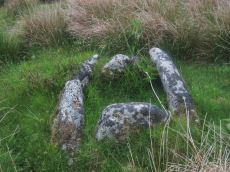
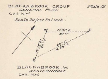
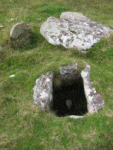
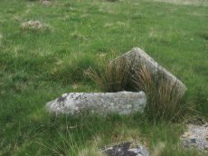
Blackabrook, East Cist
OS Map: SX 60528 73873
HER: MDV6252
Megalithic Portal: 45679
PMD: Blackabrook E.
Alternate name: Round Hill S.E.3 Cist
ShortName: CT Blackabrk E
Butler map: 65.3.3
DPD page: 104
Grinsell: LYD 82
Barrow Report: 31 44
Notes: "A well defined cist which has two stones supporting the slabs in the SE corner. The chamber measures 0.95m by 0.85m and about 0.4m deep. A turf-covered stony spread around the cist may be part of a robbed cairn." Lethbridge p.103 diagram Black Brook Cist(C), photo bottom p.104. Butler Round Hill S.E. 3 - Vol. 4. Map 65.3 (diagram of cists alongside the Blackbrook pp.230-1).

Nearby sites: SX 60528 73873
Distance: 1.37km
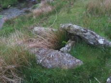
Blackabrook, South Cist
OS Map: SX 60524 73860
HER: MDV6254
Megalithic Portal: 45679
PMD: Blackabrook
Alternate name: Round Hill S.E.1 Cist
ShortName: CT Blackabrk S
Butler map: 65.3.1
DPD page: 103
Grinsell: LYD 80
Barrow Report: 31 44
Notes: "This cist with its displaced capstone lies on the edge of the river bank. Vestiges of the small surrounding cairn are now hidden under the turf. The chamber of the cist measures 1.25m by 0.55m and about 0.5m deep; the capstone is 1.5m long, 1.1m wide and 0.15m thick. The south stone has fallen outwards." Lethbridge p.103 diagram Black Brook Cist(A), photo p.103. Butler Round Hill S.E. 2. - Vol. 4. Map 65.3 (diagram of cists alongside the Blackbrook pp.230-1).
Nearby sites: SX 60524 73860
Distance: 1.38km
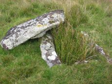
Blackabrook, West Cist
OS Map: SX 60522 73867
HER: MDV6253
Megalithic Portal: 45679
PMD: Blackabrook NW.
Alternate name: Round Hill S.E.2 Cist
ShortName: CT Blackabrk W
Butler map: 65.3.2
DPD page: 104
Grinsell: LYD 81
Barrow Report: 31 44
Notes: "The reed-filled cist is approximately 1.0m by 0.7m and about 0.2m deep. Peat has accumulated around the sides of the slabs but a few stones evident on the SW side may be part of a robbed cairn." Lethbridge p.103 diagram Black Brook Cist(B), photo p.104. Butler Round Hill S.E. 1 - Vol. 4. Map 65.3 (diagram of cists alongside the Blackbrook pp.230-1).
Nearby sites: SX 60522 73867
Distance: 1.37km
Blakey Tor (E) Cist
OS Map: SX 61312 73558
HER: MDV6245
Megalithic Portal: 28869
PMD: Blakey Tor E.
Alternate name: Blakey Tor E. Cist
ShortName: CT BlakeyTor E
Butler map: 65.4
DPD page: 102
Grinsell: LYD 85
Barrow Report: 31 47
Notes: "A reed-filled cist is set well into the cairn on a NNW-SSE axis. The intact chamber measures internally 0.95m long, a maximum 0.65m wide and 0.45m deep; the longest side slab is 1.4m by 0.3m by 0.45m and largest end slab 0.55m by 0.2m by 0.4m. The coverstone against the NW side of the cist is roughly oval in shape and measures 1.7m by 1.3m and a maximum 0.25m thick." Lethbridge diagram p.102 Cist(B), photo p.102. Butler Vol. 4. Map 65.4 (diagram p.232).
Nearby sites: SX 61312 73558
Distance: 2.13km
Blakey Tor (W) Cist
OS Map: SX 61240 73551
HER: MDV6244
Megalithic Portal: 45772
PMD: Blakey Tor W.
Alternate name: Blakey Tor W. Cist
ShortName: CT BlakeyTor W
Butler map: 65.4
DPD page: 103
Grinsell: LYD 84
Notes: "The incomplete cist is oriented NW-SE. It measures about 0.85m long, 0.4m to 0.55m wide and 0.25m deep internally. The upright W side slab is 0.9m by 0.2m by 0.25m and the surviving end slab is 0.4m by 0.2m by 0.25m. The E side is formed by a flat-sided boulder which is c. 1.1m long, at least 0.6m thick and 0.25m high. The SE side is open. The coverstone is 1.7m by 0.7m by 0.4m and leans against the W side of the cist." Lethbridge diagram p.102 Cist(A), photo top p.103. Butler Blakey Tor W. - Vol. 4. Map 65.4 (diagram p.232).
Nearby sites: SX 61240 73551
Distance: 2.08km
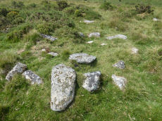
Crock of Gold Ring Setting Cairn and Cist
OS Map: SX 61286 73076
HER: MDV6308
Megalithic Portal: 14960
PMD: The Crock of Gold
ShortName: CT CrockofGold
Butler map: 65.2
DPD page: 101
Grinsell: LYD 86
Turner: D17
Barrow Report: 27 47 56
Notes: "The cairn, 7m in overall diameter and 0.3m high, has a flattish top with a retaining circle set 1m to 1.5m within the perimeter. This consists of six earthfast boulders, about 0.4m across and protruding a similar height above the cairn ... A central cist is oriented NW to SE. Internally it is 0.8m long, 0.4m wide at the NW end, 0.5m at the SE, and 0.7m deep. The side slabs are 1m long and respectively 0.15m and 0.25m thick; the end slabs, 0.5m long and 0.1m thick. The capstone, moved to the W, is 1.3m long, 1.1m wide and 0.15m thick and now rests against the kerb." Lethbridge diagram p.102 Cist(C), photo p.101. Butler Vol. 4. Map 65.2 (diagram p.229).
Nearby sites: SX 61286 73076
Distance: 2.46km
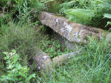
Crockern Tor Cist
OS Map: SX 61414 76055
HER: MDV57569
Megalithic Portal: 45816
PMD: Crockern Tor
Alternate name: Crockern Tor N.W. Cist
ShortName: CT CrockernTor
Butler Vol 5: p.32 & Fig.11
DPD page: 110
Notes: "Remains of a small cairn with cist on a moderate W slope in open grassland at SX 61407604 overlooking the West Dart in Crockern Newtake. It has been robbed heavily, leaving only one cist slab and fragments of the cairn material. The slab is restangular in side view and in section, firmly embedded on edge, measuring 1.2m long 0.48m high and 0.15m thick. It is aligned NW to SE." Butler Vol 5 p. 32. Lethbridge diagram and photo p.110.
Nearby sites: SX 61414 76055
Distance: 1.97km
Devil's Elbow Platform Cairn Circle
OS Map: SX 58192 72708
HER: MDV14310
Megalithic Portal: 36761
PMD: Devil's Bridge
Alternate name: Hart Tor N. Platform Cairn Circle
ShortName: PC:DevilsElbow
Butler map: 46.1
Butler Vol 5: p.168 & Fig.107
Grinsell: WAL 10
Turner: E5
Notes: Ring cairn consisting of a circle of close set stones: almost a kerb circle, interior flat and no sign of cist. Diameter 8m, height 0.3m.
Nearby sites: SX 58192 72708
Distance: 2.77km
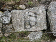
Holmingbeam Cup Stone
OS Map: SX 59488 75233
HER: MDV12807
Megalithic Portal: 10606
ShortName: CS Holmingbeam
DPD page: 107
Notes: "Mortar stone of uncertain date incorporated into the eastern boundary wall of Long Plantation. It was formerly, erroneously, recorded as a cup-marked stone." The stone is upside down in wall by road side and has the figure 18 painted on it. Lethbridge diagram and photo p.107
Nearby sites: SX 59488 75233
Distance: 0.35km
Mis Tor Farm Embanked Cairn Circle
OS Map: SX 56926 75946
HER: MDV15372
Megalithic Portal: 45609
Alternate name: Little Mis Tor S.E. Embanked Cairn Circle
ShortName: CC:MisTor Farm
Butler map: 30.17
Butler Vol 5: p.163 & Fig.104
Grinsell: LYD 37a
Turner: B13
Notes: "Base of ancient tumulus, about 20m in diameter, may have formed a bound of the ancient boundary between lydford and walkhampton (prowse)."
Nearby sites: SX 56926 75946
Distance: 2.98km
Muddilake Newtake Cist
OS Map: SX 62654 75194
HER: MDV5893
Megalithic Portal: 45745
PMD: Muddilake Newtake
ShortName: CT:Muddilake
Grinsell: LYD 105
Turner: A21
Barrow Report: 58
Notes: NMR states "A hut circle, not a cairn circle". This is almost certainly not a cist. "The measurements do not conform to those of Prowse but nothing else can be seen in the vicinity. It is most unlikely that these stones represent the remains of a cist, but are a natural occurrence." (see also duplicate HER record 5894 and SiteID=2547). This "cist" entry was listed by Dixon, however, it seems a dubious entry. This is not listed by Butler, the relevant map is Vol. 2. Map 29.9.
Nearby sites: SX 62654 75194
Distance: 2.91km
Muddy Lakes Newtake Reported Cairn
OS Map: SX 6258 7518
HER: MDV5894
Megalithic Portal: 45745
Alternate name: Muddilake West Reported Cairn
ShortName: CT?Muddilake3
Barrow Report: 58
Notes: Hut circle or cairn? Grinsell states "Traces of cairn with central slab, probably side-slab of cist. Diameter 6.0 meters, height is slight." Other observers say "no trace of cist". This is a duplicate of record 382 (HER 5893). Dixon #82. Bar Rep. 58 (TDA 71. 1939 illustration p.69).
Nearby sites: SX 6258 7518
Distance: 2.84km
Roundhill SW (N) Cist
OS Map: SX 60916 74160
HER: MDV6248
Megalithic Portal: 45680
PMD: Roundhill SW 2
Alternate name: Round Hill S.2 Cist
ShortName: CT RoundhillS2
Butler map: 65.1.5
DPD page: 106
Grinsell: LYD 76
Barrow Report: 31
Notes: Northern of a pair of cists. Butler Round Hill S. 3. (Cairn 6) - Vol. 4. Map 65.1 (p.227-9 general plan of diagram of Round Hill cairns p.228). LYDFORD 75. "A turf-covered cairn, slightly spread on the northern side, measuring 5.0 meters by 4.8 meters and 0.5 meters in height. An almost centrally placed upright slab, 0.6 meters long and 0.13 meters wide and a large slab at the foot of the mound could both be part of a disturbed cist. There is no evidence of a kerb". Lethbridge diagram p.103, photo bottom p.106.
Nearby sites: SX 60916 74160
Distance: 1.44km
Roundhill SW (S) Cist
OS Map: SX 60910 74140
HER: MDV6249
Megalithic Portal: 52683
PMD: Roundhill SW 1
Alternate name: Round Hill S.3 Cist
ShortName: CT RoundhillS3
Butler map: 65.1.6
DPD page: 106
Grinsell: LYD 75
Barrow Report: 31 44
Notes: Southern of a pair of cists. "Small turf-covered cairn with an open cist in the centre. Diameter of cairn 4.0m. Height 0.5m. The cist is practically buried under the turf now. Internal dimensions 0.85m x 0.5m. The capstone is 1.1m x 0.8m rests on the north side of the cairn. Condition of cairn and cist - fairly good. Orientation of the long axis of the cist is WNW-ESE." Lethbridge diagram p.103, photo top p.106. Butler Round Hill S. 2. (Cairn 5) - Vol. 4. Map 65.1 (p.227-9 general plan of diagram of Round Hill cairns p.228).
Nearby sites: SX 60910 74140
Distance: 1.44km
Roundhill, East of Summit Cist
OS Map: SX 61164 74413
HER: MDV6257
Megalithic Portal: 45681
PMD: Round Hill E.
Alternate name: Round Hill Summit 2 Cist
ShortName: CT Roundhill 2
Butler map: 65.1.2
DPD page: 105
Grinsell: LYD 79
Barrow Report: 31 44
Notes: "A well preserved cist, situated on a slight east-facing slope just off the crest of a rounded hilltop. It stands in isolation on a generally stone-free area of rough moorland pasture. The side slabs are each 1.2m long and up to 0.3m thick and the end slabs are 0.55m long, 0.15m wide and 0.4m long, 0.1m wide respectively. The coverstone is up to 1.6m long, 0.9m wide and 0.2m thick. There are no surface indications of either a cairn or mound around the cist." Lethbridge p.103 diagram Cist(B), photo bottom p.105. Butler Round Hill Summit 2 (Cist 2) - Vol. 4. Map 65.1 (p.227-9, diagram of Round Hill cairns p.228).
Nearby sites: SX 61164 74413
Distance: 1.53km
Roundhill, Near Summit Cist
OS Map: SX 61046 74428
HER: MDV6217
Megalithic Portal: 45682
PMD: Round Hill Summit W.
Alternate name: Round Hill Summit 1 Cist
ShortName: CT Roundhill 1
Butler map: 65.1.1
DPD page: 105
Grinsell: LYD 78
Barrow Report: 31 44
Notes: Butler Round Hill Summit 1 - Vol. 4. Map 65.1 (p.227-9, diagram of Round Hill cairns p.228). Lethbridge p.103 diagram Cist(A), photo top p.105.
Nearby sites: SX 61046 74428
Distance: 1.42km
Royal Hill Summit Cist
OS Map: SX 61295 72792
HER: MDV18391
Megalithic Portal: 45798
PMD: Royal Hill Summit
ShortName: CT RoyalHill 7
Butler map: 65.5.7
Butler Vol 5: p.185 & Fig.128
DPD page: 102
Notes: Butler Royal Hill Summit Vol. 4. Map 65.2 (diagram Vol. 5. p.185). "The cairn 7.4m E to W, and 6.5m N to S, and about 0.5m high. It is turf covered, but the tops of three stones of an inner retaining circle are exposed to a height of 0.3m. The largest is 1.1m long and 0.2m thick ... The cist, oriented E to W is largely infilled; internally it measures 0.8m by 0.6m, and is 0.2m deep. The coverstone is missing as is the stone at the E end. The others take the form of irregular boulders rather than slabs". Lethbridge diagram p.102 Cist(D), photo p.102.
Nearby sites: SX 61295 72792
Distance: 2.69km
Thornworthy 2 Cist
OS Map: SX 59015 73471
HER: MDV6613
Megalithic Portal: 15453
PMD: Thornworthy
ShortName: CT Thornworth2
Butler map: 35.22
Butler Vol 5: p.64 & Fig.42
DPD page: 137
Grinsell: CHA 3
Turner: E39
Barrow Report: 56
Notes: Located at the High Moorland Visitor Centre at Princetown. There were two cists at Thornworthy and both were excavated. This record refers to the second slightly smaller cist. This was removed after the excavation and re-erected at Torquay Museum. The cist is located in the Jack Wigmore Garden (also known as the Dartmoor Conservation Garden). It can be accessed from the ballroom of the Visitors Centre or alternatively by walking a very short distance down from the mini roundabout outside the centre down the Yelverton Road (Plymouth Hill). A gate on the right hand side behind the visitors centre gives access to the garden. See also: Thornworthy Cist. Butler Vol. 2. Map 35.22 p.169, see also diagram Vol. 5. p.64.
Nearby sites: SX 59015 73471
Distance: 1.70km
Wistman's wood Settlement
OS Map: SX 6125 7750
HER: MDV66036
Megalithic Portal: 42854
ShortName: ST:Wistmans
Nearby sites: SX 6125 7750
Distance: 2.92km