
Blackabrook, East Cist
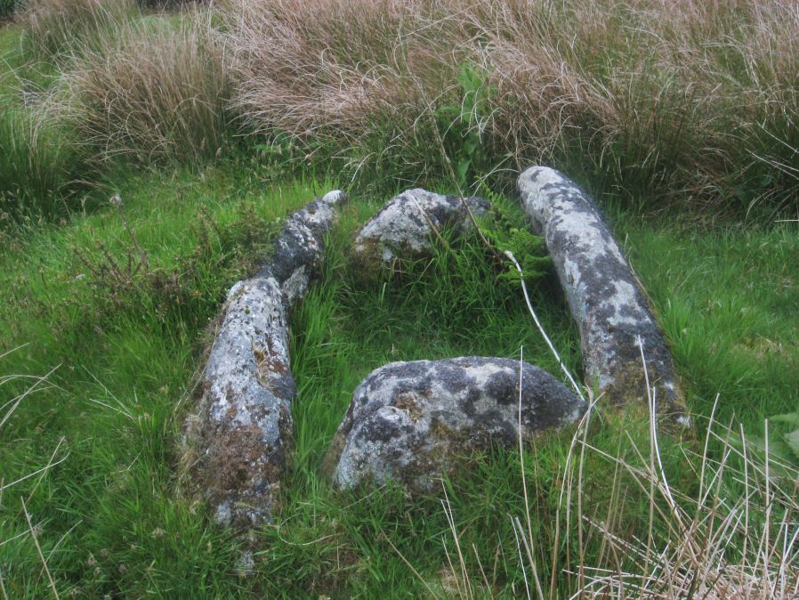
Photo taken on 04-06-2016
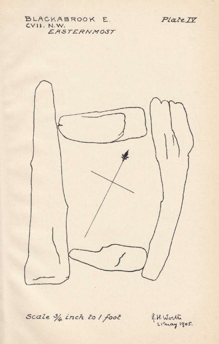
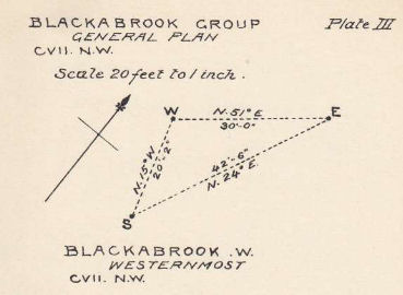
Plan by RHW. Barrow Report 31. TDA Vol.44 1912
Database entries
OS Map: SX 60528 73873
OS Source: Garmin
Butler OS: SX60527385
HER: MDV6252
Megalithic Portal: 45679
PMD: Blackabrook E.
Alternate name: Round Hill S.E.3
Short Name: CT Blackbrk E
Butler map: 65.3.3
Dixon Cist #: 33
Grinsell: LYDFORD 82
DPD page: 104
Exist: Yes
Record: Unique
Record Source: Butler
Hut Class: No
Cist Class: Yes
Cairn Class: Yes
Barrow Report: 31 44
Dimensions (m): 0.95 x 0.85 C
Lidar: SX 60528 73873
Guide Map: 34
Nearest Bus Stop: Two Bridges Hotel (1.6 km) [Route: 98,171(20/07/26 to 19/09/26)]
Nearby sites: SX 60528 73873
Notes
"A well defined cist which has two stones supporting the slabs in the SE corner. The chamber measures 0.95m by 0.85m and about 0.4m deep. A turf-covered stony spread around the cist may be part of a robbed cairn." Lethbridge p.103 diagram Black Brook Cist(C), photo bottom p.104. Butler Round Hill S.E. 3 - Vol. 4. Map 65.3 (diagram of cists alongside the Blackbrook pp.230-1).Plan by R.H. Worth of Blackabrook cairn group in Barrow Report 31.
References
These are selected references with an emphasis on out of copyright sources linked as PDFs. For more detailed references try any linked HER or PMD record above.
- Burnard, Robert, Notes on Dartmoor Kistvaens, T.D.A. Vol.22 pp.200-207 (1890)
- Butler, Jeremy, Dartmoor Atlas of Antiquities, vol.4: The South-East, (1993)
- Grinsell, L.V., Dartmoor Barrows, Devon Archaeological Society Proceedings No.36 (1978)
- Lethbridge, William D., Discover Preshistoric Dartmoor, (2015)
- Prowse, Arthur B., The Antiquities of Ockery and Roundhill, T.D.A. Vol.33 pp.495-499 (1901)
- Worth, R. Hansford, Barrow Report 31, T.D.A. Vol.44 pp.83-5 (1912)
- Worth, R. Hansford, Barrow Report 44, T.D.A. Vol.57 p.71 (1925)