
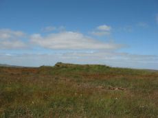
Prehistoric sites within 3km of SX 59500 83600
Guidance for walkers: The monuments featured in this database are archaeological treasures and need to be protected and preserved - please do not disturb any sites. Please check access and firing times before visiting sites, not all sites listed are on open access land. Firing ranges and boundaries of open access areas are marked on the OL28 OS Dartmoor Explorer map. Please stick to the country code and consider giving support to the numerous agencies that help to keep Dartmoor a fabulous natural and historic environment!
About the database listings: In all listings clicking on the photo or the site name will open a page for the site with a larger photo and further details from the database. The database now has over 6680 records covering nearly all publicly listed sites on Dartmoor including around 4800 round houses. This level of detail is of interest to archaeologists but tends to swamp listings of sites more likely to be of interest for walkers. For this reason, the listings default to around 550 core sites only. These are the stone circles, stone rows and the ring cairns listed by Turner. The default search radius is 2 km. The controls below the map can be used to start a new search by entering a 6- or 8-digit reference (without the prefix "SX"). The search radius can be specified and you can add incremental Display layers of detail on top of the core sites. If using a more detailed layer you will need to decrease the search radius to avoid getting hundreds of search results.
- Core sites Default listing of core sites consisting of stone circles & rows and some of the major ring cairns.
- Plus cairns adds approx. 1000 cairns and other minor sites not included in the core listings but excluding round houses.
- Plus round houses adds approx. 4800 round houses.
- Plus non-sites adds in the records for sites that no longer exist or are not prehistoric sites.
- Plus duplicates adds records excluded as duplicates. Those maybe duplicate records in external listings (e.g. the Historic Environment Records). For example, some sites have been identified as cairns in some listings and interpreted as round houses in other listings and both records appear.
These listings have incorporated, matched up and merged all of the records from all of the major archaeological listings including: Worth, Grinsell, Turner, Butler, Bill Radcliffe, Sandy Gerrard, Megalithic Portal, the National Monument Records and the Historic Environment Records. The author would like to thank Bill, Sandy, the lovely people both at Megalithic Portal (especially Anne Tate who did an amazing job to link listings) and at ACE Archaeology for collaborative work over the years to synchronise and correct listings across the various websites which now interlink. A culmination of years of work the final merger of cairn records took 3 months of cross referencing in 2017 the result being a snapshot of the records at that time. This data has in turn been refined since by field work and research. The round house data was supplied by Sandy Gerrard. Grid references are in order of accuracy: from Google Earth satellite, if visible and found, from a Garmin GPS reading, if visited by the author and from the literature otherwise. Individual site pages will state the source of the grid reference and provide satellite imagery. If a site listing lacks a photo it has not yet been visited by the author in which case the grid reference is from the literature.
Currently the database only includes sites which can be represented by a grid reference. Reaves are not included as they require GIS shape technology which is beyond the current capability of this system. To see the sources for the records, look at the tables on the resources menu. The database listings can also be viewed on a Google map and downloaded as GPS datasets for Garmin devices.
Corrections, or any feedback or suggestions are very welcome, email: info@dartmoorwalks.org.uk.
NOTE: Clicking on the icons for each monument in the map will give the name of the site. You can zoom in and out and drag the map around.
List of sites within 3km of SX 59500 83600
Black Ridge Round House
OS Map: SX 5954 8484
HER: MDV28318
ShortName: HT:Black Rid1
Nearby sites: SX 5954 8484
Distance: 1.24km
Watern Oke Round House
OS Map: SX 56764 83347
HER: MDV3553
ShortName: HT:WaternOk1
Nearby sites: SX 56764 83347
Distance: 2.75km
Watern Oke Round House
OS Map: SX 56780 83357
HER: MDV3554
ShortName: HT:WaternOk6
Nearby sites: SX 56780 83357
Distance: 2.73km
Watern Oke Round House
OS Map: SX 56792 83358
HER: MDV3556
ShortName: HT:WaternOk7
Nearby sites: SX 56792 83358
Distance: 2.72km
Watern Oke Round House
OS Map: SX 56799 83345
HER: MDV3555
ShortName: HT:WaternOk9
Nearby sites: SX 56799 83345
Distance: 2.71km
Watern Oke Round House
OS Map: SX 56800 83336
HER: MDV50391
ShortName: HT:WaternOk11
Nearby sites: SX 56800 83336
Distance: 2.71km
Watern Oke Round House
OS Map: SX 56801 83342
HER: MDV3555
ShortName: HT:WaternOk12
Nearby sites: SX 56801 83342
Distance: 2.71km
Watern Oke Round House
OS Map: SX 56806 83357
HER: MDV27108
ShortName: HT:WaternOk13
Nearby sites: SX 56806 83357
Distance: 2.70km
Watern Oke Round House
OS Map: SX 56813 83346
HER: MDV50395
ShortName: HT:WaternOk14
Nearby sites: SX 56813 83346
Distance: 2.70km
Watern Oke Round House
OS Map: SX 56566 83396
HER: MDV3312
ShortName: HT:WaternOk17
Nearby sites: SX 56566 83396
Distance: 2.94km
Watern Oke Round House
OS Map: SX 56563 83336
HER: MDV3312
ShortName: HT:WaternOk19
Nearby sites: SX 56563 83336
Distance: 2.95km
Watern Oke Round House
OS Map: SX 56831 83343
HER: MDV50392
ShortName: HT:WaternOk31
Nearby sites: SX 56831 83343
Distance: 2.68km
Fur Tor Reported Cist
OS Map: SX 5783 8305
HER: MDV66000
ShortName: CT:Fur Tor
Notes: Cairn with cist approx 1km w of fur tor.
Nearby sites: SX 5783 8305
Distance: 1.76km
Watern Oke Round House
OS Map: SX 56915 83375
ShortName: HT:WaternOk51
Nearby sites: SX 56915 83375
Distance: 2.59km
Watern Oke Round House
OS Map: SX 56840 83352
HER: MDV3558
ShortName: HT:WaternOk53
Nearby sites: SX 56840 83352
Distance: 2.67km
Watern Oke Round House
OS Map: SX 56897 83381
ShortName: HT:WaternOk57
Nearby sites: SX 56897 83381
Distance: 2.61km
Watern Oke Round House
OS Map: SX 56912 83369
ShortName: HT:WaternOk59
Nearby sites: SX 56912 83369
Distance: 2.60km
Watern Oke Round House
OS Map: SX 56826 83353
HER: MDV3557
ShortName: HT:WaternOk60
Nearby sites: SX 56826 83353
Distance: 2.69km
Watern Oke Round House
OS Map: SX 56920 83385
ShortName: HT:WaternOk61
Nearby sites: SX 56920 83385
Distance: 2.59km
Watern Oke Round House
OS Map: SX 56931 83384
ShortName: HT:WaternOk62
Nearby sites: SX 56931 83384
Distance: 2.58km
Watern Oke Round House
OS Map: SX 56972 83425
HER: MDV50157
ShortName: HT:WaternOk66
Nearby sites: SX 56972 83425
Distance: 2.53km
Watern Oke Round House
OS Map: SX 56905 83375
ShortName: HT:WaternOk68
Nearby sites: SX 56905 83375
Distance: 2.60km
Watern Oke Round House
OS Map: SX 5667 8332
HER: MDV103669
ShortName: HT:WaternOk69
Nearby sites: SX 5667 8332
Distance: 2.84km
Watern Oke Round House
OS Map: SX 56513 83371
HER: MDV3312
ShortName: HT:WaternOk73
Nearby sites: SX 56513 83371
Distance: 3.00km
Watern Oke Round House
OS Map: SX 56524 83449
HER: MDV3312
ShortName: HT:WaternOk77
Nearby sites: SX 56524 83449
Distance: 2.98km
Watern Oke Round House
OS Map: SX 5667 8332
HER: MDV103669
ShortName: HT:WaternOk78
Nearby sites: SX 5667 8332
Distance: 2.84km
Great Kneeset Cairn
OS Map: SX 58347 86242
HER: MDV103608
ShortName: CN:Great Kne1
Nearby sites: SX 58347 86242
Distance: 2.88km
Watern Oke Round House
OS Map: SX 56547 83406
HER: MDV3312
ShortName: HT:WaternOk89
Nearby sites: SX 56547 83406
Distance: 2.96km
Watern Oke Round House
OS Map: SX 56529 83449
HER: MDV3312
ShortName: HT:WaternOk90
Nearby sites: SX 56529 83449
Distance: 2.97km
Watern Oke Round House
OS Map: SX 56527 83368
HER: MDV3312
ShortName: HT:WaternOk94
Nearby sites: SX 56527 83368
Distance: 2.98km
Watern Oke Round House
OS Map: SX 56560 83341
HER: MDV3312
ShortName: HT:WaternOk95
Nearby sites: SX 56560 83341
Distance: 2.95km
Watern Oke Round House
OS Map: SX 56531 83468
HER: MDV3312
ShortName: HT:WaternOk96
Nearby sites: SX 56531 83468
Distance: 2.97km
Watern Oke Round House
OS Map: SX 56554 83401
HER: MDV3312
ShortName: HT:WaternOk97
Nearby sites: SX 56554 83401
Distance: 2.95km
Watern Oke Round House
OS Map: SX 56537 83449
HER: MDV3312
ShortName: HT:WaternOk98
Nearby sites: SX 56537 83449
Distance: 2.97km
Watern Oke Round House
OS Map: SX 56537 83420
HER: MDV3312
ShortName: HT:WaternOk99
Nearby sites: SX 56537 83420
Distance: 2.97km
Watern Oke Round House
OS Map: SX 56540 83402
HER: MDV3312
ShortName: HT:WaternOk100
Nearby sites: SX 56540 83402
Distance: 2.97km
Watern Oke Round House
OS Map: SX 56518 83352
HER: MDV3312
ShortName: HT:WaternOk102
Nearby sites: SX 56518 83352
Distance: 2.99km
Whitehorse Hill 2 Reported Cairn
OS Map: SX 61722 85017
HER: MDV7758
ShortName: CN:Whitehors2
Notes: "The remains of a possible hut circle or cairn is visible as a crude circle of upright stones. The stones are partially turf-covered and measure up to 0.4 metres high."
Nearby sites: SX 61722 85017
Distance: 2.64km
Kneeset Nose Reported Cist
OS Map: SX 588 865
HER: MDV7727
PMD: Great Kneeset
ShortName: CT?Kneeset N1
Notes: A cist is recorded on Kneeset Nose by the County Sites and Monuments Record. It was not found during field investigation although two walkers knew of the cist, perhaps at a nearby location.
Nearby sites: SX 588 865
Distance: 2.98km
Western Red Lake Round House
OS Map: SX 56558 83131
HER: MDV3312
ShortName: HT:Western R1
Nearby sites: SX 56558 83131
Distance: 2.98km
Western Red Lake Round House
OS Map: SX 56648 83124
HER: MDV19434
ShortName: HT:Western R3
Nearby sites: SX 56648 83124
Distance: 2.89km
Quintin's Man Cairn
OS Map: SX 62101 83872
HER: MDV6765
ShortName: CN:Quintin's1
Butler map: 34.1
Grinsell: LYD 15
Notes: "Quintin's man; the placename seems to indicate the existence of a menhir, but the object to which it is applied is to a cairn. No record of a menhir standing by a cairn." Cairn (heig 1.83m, diam 20.1m).
Nearby sites: SX 62101 83872
Distance: 2.62km
Quintin's Man (Near) Reported Cairn
OS Map: SX 6212 8384
HER: MDV13033
ShortName: CN?Quintin's2
Butler map: 34.1
Grinsell: LYD 15a
Notes: Grid reference from Grinsell
Nearby sites: SX 6212 8384
Distance: 2.63km
Marsh Hill Reported Cairn
OS Map: SX 62150 82427
HER: MDV6776
PMD: Statt's House
ShortName: CT?Marsh Hil1
Butler map: 34.2
Grinsell: LYD 34
Notes: Possible cairn but thought to have been the remains of a collapsed house similar to Stat's House a few metres to the north. The mound has been much disturbed by the construction of a shelter in its centre. This is a trapezoidal structure, 1.2m wide at its northwestern end, 1.7m wide at its northeastern end and 3.1m long. The coursed walls are 1.1m wide and 0.6m high. The slab inside the shelter represents tumble from this structure rather than part of a cist as suggested by Grinsell.
Nearby sites: SX 62150 82427
Distance: 2.90km
Cranmere Pool Ancient Pool
OS Map: SX 60323 85829
HER: MDV4381
ShortName: PO:Cranmere
Notes: "Recorded in the early 20th century as a possible holy well, it is one of the examples suggested by Greeves (2019) to potentially have Prehistoric origins."
Nearby sites: SX 60323 85829
Distance: 2.38km
Cut Hill Cairn
OS Map: SX 59823 82745
HER: MDV69603
Megalithic Portal: 47078
PMD: Cut Hill
ShortName: CN Cut Hill
DPD page: 130
Notes: "Barrow c20m overall diameter on the top of 'Cut Hill' at 603m OD was observed during a field visit by Tom Greeves in 2004. The 1.5m high circular mound has a military range pole set in it & surface erosion has exposed a turf/peat core with a few stones. The surrounding ditch is over 1m wide & nearly filled with waterlogged vegetation." For more information, see: Prehistoric Society - Past No. 47 and Prehistoric Society - Past No. 47. The date and context of a stone row:Cut Hill, Dartmoor, south-west England. The HER gives the OS grid reference as SX 5992 8275 which is almost 100 metres to the east.
Nearby sites: SX 59823 82745
Distance: 0.91km
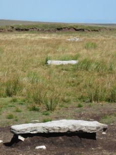
Cut Hill Stone Row
OS Map: SX 59871 82756
HER: MDV69604
Megalithic Portal: 25916
The Stone Rows of GB: Cut Hill
PMD: Cut Hill Stone Row
ShortName: SR Cut Hill
DPD page: 130
Notes: Discovered in 2004. Prehistoric stone row of 6-7 large granite slabs near the summit of Cut Hill. All the slabs are recumbent with one buried. The row is thought to date back earlier than 3,500BC. For more information, see: Cut Hill, Dartmoor (phase 3), Stone row chronology and landscape change, HER MDV69604 and Legendary Dartmoor
Nearby sites: SX 59871 82756
Distance: 0.92km
Quintins Man Standing Stone
OS Map: SX 62101 83873
HER: MDV6765
Megalithic Portal: 45860
PMD: Quintins Man
ShortName: SSxQuintinsMan
Butler map: 34.1
Notes: "A cairn. The name implies a standing stone, but there is no knowledge of one in living memory." [worth] See also, Legendary Dartmoor: Dartmoor's Quintin's Man
Nearby sites: SX 62101 83873
Distance: 2.62km
Quintins Man A Ancient Pool
OS Map: SX 62102 83952
HER: MDV27278
ShortName: PO:QuintinsA
Notes: "Previously identified as a prehistoric barrow, survey work in 1995 suggested this to be a natural feature. One of over 40 'sacred' pools identified by Greeves (2019) that may have prehistoric origin. Lies north of the Quintin's Man cairn."
Nearby sites: SX 62102 83952
Distance: 2.63km
Quintins Man B Ancient Pool
OS Map: SX 62053 84056
HER: MDV127217
ShortName: PO:QuintinsB
Notes: "A pool measuring 20 by 16m. One of over 40 such 'sacred' pools identified on Dartmoor that are thought to have potentially been designed during the prehistoric period."
Nearby sites: SX 62053 84056
Distance: 2.59km
Quintins Man C Ancient Pool
OS Map: SX 61972 84365
HER: MDV127218
ShortName: PO:QuintinsC
Notes: "Pool north of Quintin's Man measures 12 by 8m. One of over 40 such 'sacred' pools identified on Dartmoor that are thought to have potentially been designed during the prehistoric period"
Nearby sites: SX 61972 84365
Distance: 2.59km
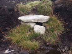
Whitehorse Hill Cist
OS Map: SX 61735 85482
HER: MDV66367
Megalithic Portal: 29778
PMD: White Horse Hill
ShortName: CT Whitehorse
DPD page: 131
Notes: This cist was excavated in August 2011. It featured on an 1892 map by John Chudleigh in An Exploration of Dartmoor's Antiquities. It was re-discovered in 2001 and recently excavated. Carbon dating suggests it is Bronze Age in date. Dates for the top of the cist gives 2800-1890BC and for the bottom of the cist 3650-3100BC. Provisional carbon dates for artifacts suggest the remains are Bronze Age (1900-1500BC). Inside the cist an animal hide bag was found containing cremation remains including a number of artefacts including amber beads (amber would have been imported from overseas), wooden ear studs, a delicate bracelet studded with tin beads, a textile fragment with detailed leather fringing and a unique coiled bag.
There is some good coverage on the Legendary Dartmoor website, see: Whitehorse Kist 1, Whitehorse Kist 2 and Whitehorse Kist 3.
See also DNPA: Update on Whitehorse Hill Cist excavation and Dartmoor tomb treasure horde uncovered by archaeologists. Not listed in Butler - relevant map of area is Vol. 2. Map 41. Lethbridge pp.131-132
Nearby sites: SX 61735 85482
Distance: 2.92km