
Prehistoric sites within 2km of SX 59300 91100
Guidance for walkers: The monuments featured in this database are archaeological treasures and need to be protected and preserved - please do not disturb any sites. Please check access and firing times before visiting sites, not all sites listed are on open access land. Firing ranges and boundaries of open access areas are marked on the OL28 OS Dartmoor Explorer map. Please stick to the country code and consider giving support to the numerous agencies that help to keep Dartmoor a fabulous natural and historic environment!
About the database listings: In all listings clicking on the photo or the site name will open a page for the site with a larger photo and further details from the database. The database now has over 6680 records covering nearly all publicly listed sites on Dartmoor including around 4800 round houses. This level of detail is of interest to archaeologists but tends to swamp listings of sites more likely to be of interest for walkers. For this reason, the listings default to around 550 core sites only. These are the stone circles, stone rows and the ring cairns listed by Turner. The default search radius is 2 km. The controls below the map can be used to start a new search by entering a 6- or 8-digit reference (without the prefix "SX"). The search radius can be specified and you can add incremental Display layers of detail on top of the core sites. If using a more detailed layer you will need to decrease the search radius to avoid getting hundreds of search results.
- Core sites Default listing of core sites consisting of stone circles & rows and some of the major ring cairns.
- Plus cairns adds approx. 1000 cairns and other minor sites not included in the core listings but excluding round houses.
- Plus round houses adds approx. 4800 round houses.
- Plus non-sites adds in the records for sites that no longer exist or are not prehistoric sites.
- Plus duplicates adds records excluded as duplicates. Those maybe duplicate records in external listings (e.g. the Historic Environment Records). For example, some sites have been identified as cairns in some listings and interpreted as round houses in other listings and both records appear.
These listings have incorporated, matched up and merged all of the records from all of the major archaeological listings including: Worth, Grinsell, Turner, Butler, Bill Radcliffe, Sandy Gerrard, Megalithic Portal, the National Monument Records and the Historic Environment Records. The author would like to thank Bill, Sandy, the lovely people both at Megalithic Portal (especially Anne Tate who did an amazing job to link listings) and at ACE Archaeology for collaborative work over the years to synchronise and correct listings across the various websites which now interlink. A culmination of years of work the final merger of cairn records took 3 months of cross referencing in 2017 the result being a snapshot of the records at that time. This data has in turn been refined since by field work and research. The round house data was supplied by Sandy Gerrard. Grid references are in order of accuracy: from Google Earth satellite, if visible and found, from a Garmin GPS reading, if visited by the author and from the literature otherwise. Individual site pages will state the source of the grid reference and provide satellite imagery. If a site listing lacks a photo it has not yet been visited by the author in which case the grid reference is from the literature.
Currently the database only includes sites which can be represented by a grid reference. Reaves are not included as they require GIS shape technology which is beyond the current capability of this system. To see the sources for the records, look at the tables on the resources menu. The database listings can also be viewed on a Google map and downloaded as GPS datasets for Garmin devices.
Corrections, or any feedback or suggestions are very welcome, email: info@dartmoorwalks.org.uk.
NOTE: Clicking on the icons for each monument in the map will give the name of the site. You can zoom in and out and drag the map around.
List of sites within 2km of SX 59300 91100
Black Down W. Platform Cairn Circle and Cist
OS Map: SX 57398 91540
HER: MDV61332
Megalithic Portal: 45801
PMD: Black Down
ShortName: CT:BlackDown W
Butler map: 42.6
Butler Vol 5: p.58 & Fig.35
Notes: Not located at SX 57409153 on 28/08/16. Butler SX57389153. NMR SX57469153."The cairn is 6 metres in diameter and 0.7 metres in height. The cist is 0.9 metres long with 2 end stones in the original position. Remains of a kerb are visible around the north west edge of the mound". 1.6km east of Higher Bowden. nb. Not listed by Turner - assigned as "Platform Circle" type cairn due to description in NMR. "A flat-topped cairn". Butler Black Down W. Vol. 2. Map 42.6 (diagram Vol 5. p.58).
Nearby sites: SX 57398 91540
Distance: 1.95km
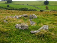
Cullever Steps Ring Setting Cairn and Cist
OS Map: SX 60787 91954
HER: MDV6867
Megalithic Portal: 17956
PMD: Cullever Steps
ShortName: CT Cullever
Butler map: 40.14
Butler Vol 5: p.181 & Fig.123
Grinsell: BEL 2
Turner: D11
Notes: "A Bronze Age ring cairn situated below Belstone Tor within the valley of the East Okement River. The cairn survives as a 0.5 metre high bank surrounding a 4.1 metre diameter internal area. The bank around the southern and eastern side of the cairn is faced on both sides with edge set stones. A large flat stone lying on the south western part of the ring bank may represent a displaced cist coverstone. The overall dimensions of the cairn are 9.5 metres east to west by 8.5 metres north to south." Butler Vol. 2. Map 40.14 (diagram Vol. 5. p.181).
Nearby sites: SX 60787 91954
Distance: 1.71km
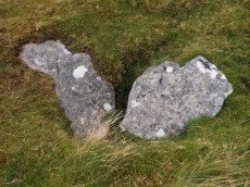
Winter Tor Cist
OS Map: SX 61112 91352
HER: MDV6881
Megalithic Portal: 45779
PMD: Winter Tor
Alternate name: Higher Tor S.1 Cist
ShortName: CT HigherTor 1
Butler map: 40.15
Butler Vol 5: p.169 & Fig.108
Grinsell: LYD 1
Notes: [Formerly listed as Higher Tor (S), renamed after PMD] Butler Higher Tor (S) Vol. 2. Map 40.15. (diagram Vol. 5. p.169). Ths cist was excavated by Prowse as described in his article of 1890. About 300 yards south-south-east of Winter Tor is a tumulus diameter 9 yards and height 3 feet, the top of which has been hollowed out. Within the hollow was a granite slab 4 feet 6 inches by 2 feet 9 inches, covering the remains of a cist, and another slab approximately 4 feet 9 inches by 3 feet 3 inches, either a second capstone or possibly part of the first cist. The cist contained nothing of interest except a few small porous and very brittle fragments of what is apparently bony tissue. After examination the capstone was replaced and covered with soil and stones.
Nearby sites: SX 61112 91352
Distance: 1.83km
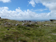
Yes Tor E Cairn
OS Map: SX 58044 90185
HER: MDV4814
Megalithic Portal: 36416
Alternate name: Yes Tor 2 Cairn
ShortName: CN Yes Tor E
Butler map: 42.1.2
Grinsell: OKE 2
Notes: One of two cairns on Yes Tor. On the top of the flat outcrop of Yes Tor and piled against the west side is an amorphous mass of stones representing a ruined cairn. The patch of stones on the top is more or less 14.0m across and 0.3 m high and the piling against the outcrop is 2.3m high. It is possible that this has resulted from bulldozing the cairn over the side of the outcrop but the stones appear quite stable and compacted.
Nearby sites: SX 58044 90185
Distance: 1.55km
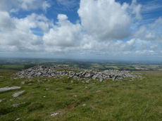
Yes Tor W Cairn
OS Map: SX 57955 90210
HER: MDV4813
Megalithic Portal: 36416
Alternate name: Yes Tor 1 Cairn
ShortName: CN Yes Tor W
Butler map: 42.1.1
Grinsell: OKE 1
Notes: Western of two round barrows on the summit of yes tor. About 36.6m nw of flag staff on the top of yes tor is an incomplete ring of rough granite boulders varying in size but generally 0.3m - 0.9m. Long. The ring is about 6.1m long and is defective on the north east side where there is evidence of a slightly sunken trackway. In the interior of this ring the ground is slightly irregular and contains blocks of granite. At the south western part of the circle a smaller circle of stones abuts on the previous circle. Butler Volume 2 Map 42.1.
Nearby sites: SX 57955 90210
Distance: 1.61km