
Prehistoric sites within 2km of SX 54200 72000
Guidance for walkers: The monuments featured in this database are archaeological treasures and need to be protected and preserved - please do not disturb any sites. Please check access and firing times before visiting sites, not all sites listed are on open access land. Firing ranges and boundaries of open access areas are marked on the OL28 OS Dartmoor Explorer map. Please stick to the country code and consider giving support to the numerous agencies that help to keep Dartmoor a fabulous natural and historic environment!
About the database listings: In all listings clicking on the photo or the site name will open a page for the site with a larger photo and further details from the database. The database now has over 6680 records covering nearly all publicly listed sites on Dartmoor including around 4800 round houses. This level of detail is of interest to archaeologists but tends to swamp listings of sites more likely to be of interest for walkers. For this reason, the listings default to around 550 core sites only. These are the stone circles, stone rows and the ring cairns listed by Turner. The default search radius is 2 km. The controls below the map can be used to start a new search by entering a 6- or 8-digit reference (without the prefix "SX"). The search radius can be specified and you can add incremental Display layers of detail on top of the core sites. If using a more detailed layer you will need to decrease the search radius to avoid getting hundreds of search results.
- Core sites Default listing of core sites consisting of stone circles & rows and some of the major ring cairns.
- Plus cairns adds approx. 1000 cairns and other minor sites not included in the core listings but excluding round houses.
- Plus round houses adds approx. 4800 round houses.
- Plus non-sites adds in the records for sites that no longer exist or are not prehistoric sites.
- Plus duplicates adds records excluded as duplicates. Those maybe duplicate records in external listings (e.g. the Historic Environment Records). For example, some sites have been identified as cairns in some listings and interpreted as round houses in other listings and both records appear.
These listings have incorporated, matched up and merged all of the records from all of the major archaeological listings including: Worth, Grinsell, Turner, Butler, Bill Radcliffe, Sandy Gerrard, Megalithic Portal, the National Monument Records and the Historic Environment Records. The author would like to thank Bill, Sandy, the lovely people both at Megalithic Portal (especially Anne Tate who did an amazing job to link listings) and at ACE Archaeology for collaborative work over the years to synchronise and correct listings across the various websites which now interlink. A culmination of years of work the final merger of cairn records took 3 months of cross referencing in 2017 the result being a snapshot of the records at that time. This data has in turn been refined since by field work and research. The round house data was supplied by Sandy Gerrard. Grid references are in order of accuracy: from Google Earth satellite, if visible and found, from a Garmin GPS reading, if visited by the author and from the literature otherwise. Individual site pages will state the source of the grid reference and provide satellite imagery. If a site listing lacks a photo it has not yet been visited by the author in which case the grid reference is from the literature.
Currently the database only includes sites which can be represented by a grid reference. Reaves are not included as they require GIS shape technology which is beyond the current capability of this system. To see the sources for the records, look at the tables on the resources menu. The database listings can also be viewed on a Google map and downloaded as GPS datasets for Garmin devices.
Corrections, or any feedback or suggestions are very welcome, email: info@dartmoorwalks.org.uk.
NOTE: Clicking on the icons for each monument in the map will give the name of the site. You can zoom in and out and drag the map around.
List of sites within 2km of SX 54200 72000
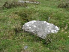
Ingra Tor Cist
Prehistoric Dartmoor Walks: Dartmoor Walk: Sharpitor area Stone Rows and Cists
OS Map: SX 55874 72093
HER: MDV4983
Megalithic Portal: 45735
PMD: Ingra Tor
Alternate name: lngra Tor Cist
ShortName: CT Ingra Tor
Butler map: 45.16
DPD page: 19
Grinsell: WAL 9
Barrow Report: 56
Notes: Butler Vol. 3. Map 45.16 (diagram p.51).
Breton (p.12): About 300 yds E. of Ingra tor is a fine kistvaen which has not been disturbed, except that a portion of the capstone has been broken off. [...] Three men from the farm near by about 1910 tried to raise the capstone with crowbars, but they failed to move it ; however, they broke off the piece that is broken.
Nearby sites: SX 55874 72093
Distance: 1.68km
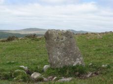
Leeden Hill Standing Stone
Prehistoric Dartmoor Walks: Dartmoor Walk: Sharpitor area Stone Rows and Cists
OS Map: SX 56015 71286
HER: MDV28499
Megalithic Portal: 45567
PMD: Leeden Hill Standing Stone
ShortName: SS Leeden Hill
Butler map: 45.
Notes: Possibly a prehistoric standing stone but may also be a much later marker since there are at least three similar stones in a line towards Ingra Tor set out at wide intervals as if to mark a boundary
Nearby sites: SX 56015 71286
Distance: 1.95km

Pew Tor (N side) Ancient Pool
OS Map: SX 53354 73597
HER: MDV127216
ShortName: PO Pew Tor
Notes: "A pool measuring 28 by 14m. One of over 40 such 'sacred' pools identified on Dartmoor that are thought to have potentially been designed during the prehistoric period."
Nearby sites: SX 53354 73597
Distance: 1.81km
Routrundle North Enclosed Settlement
Prehistoric Dartmoor Walks: Dartmoor Walk: Sharpitor area Stone Rows and Cists
OS Map: SX 55384 71860
HER: MDV105688
Megalithic Portal: 45577
ShortName: ES:Routrundl N
Notes: Routrundle North Pound: "Broadly oval enclosure, 58 by 48 metres diameter. Part of the south-west perimeter is represented by a stony scarp 0.5 metres high, elsewhere it comprises a stone spread of similar height upon which is a modern field wall."
Nearby sites: SX 55384 71860
Distance: 1.19km
Routrundle south Enclosed Settlement
Prehistoric Dartmoor Walks: Dartmoor Walk: Sharpitor area Stone Rows and Cists
OS Map: SX 55262 71735
HER: MDV3775
Megalithic Portal: 45578
ShortName: ES:Routrundl S
Notes: Routrundle South Pound: "A roughly oval field with diameters of 58.0 metres by 64.0 metres and a modern perimeter wall 1.5 metres high. There are no obvious footings of a previous wall but the plan and size (0.25 hectares) suggest that it is the fossilization of a prehistoric enclosure similar to that 250 metres to the north-east."
Nearby sites: SX 55262 71735
Distance: 1.09km
Sharpitor W. (Peek Hill) Cairn Circle
Prehistoric Dartmoor Walks: Dartmoor Walk: Sharpitor area Stone Rows and Cists
OS Map: SX 55056 70751
HER: MDV5011
Megalithic Portal: 52566
PMD: Sharpitor W Stone Row
Alternate name: Sharpitor W. stone row Cairn Circle
ShortName: CC Sharpitor W
Butler map: 45.11
DPD page: 20
Grinsell: WAL 18
Notes: "The cairn lies on a gentle sw slope ne of horseyeatt farm, with a stone row see sx57se/141 running sw from it. The cairn is about 7m in diameter and 0.6m height, partly turf-covered, with a central hollow. The visible set stones within the cairn suggest two or three underlying concentric stone circles. These stones have a maximum height of 0.2m and are predominantly set with their long axes tangential to the circle". Lethbridge pp.19-20, diagram p.19.
Nearby sites: SX 55056 70751
Distance: 1.51km
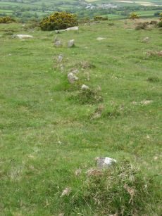
Sharpitor W. (Peek Hill) Stone Row
Prehistoric Dartmoor Walks: Dartmoor Walk: Sharpitor area Stone Rows and Cists
OS Map: SX 55058 70748
HER: MDV12831
Megalithic Portal: 2120
The Stone Rows of GB: Sharpitor West
PMD: Sharpitor W Stone Row
Alternate name: Sharpitor W Stone Row
ShortName: SR Sharpitor W
Butler map: 45.11
DPD page: 20
Notes: Butler: Sharpitor W, Worth: Peek Hill. Near Horseyeat Farm. "BA stone row and cairn. The 132m long row has 47 upright stones and the low cairn is 8.4m in diameter. Both monuments lie under dense bracken cover; gorse vegetation has obscured part of the row". Lethbridge pp.19-20, diagram p.19, photo p.20 Horseyeat Farm stone row. See also: Sea Views at Sharpitor West
Nearby sites: SX 55058 70748
Distance: 1.52km