
Guide to the Monuments on Penn Moor
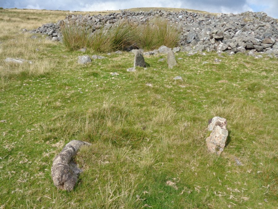
Table of Ritual and Burial Monuments on Penn Moor
The following table lists the records currently in this Guide Map. For an explantion of the Guide Maps and a table of all 62 Guide Maps, follow this link: Guide List Table. Introductory text will be added to each guide list in 2025. Notes on duplication and omissions will appear below the table once checks have been finalised.
Notes on possible duplications and omissions
Rook Tor Cairn Circle(s): Both Turner and Butler list a Rook Tor cairn circle with grid references that put the two 1km apart but they have similiar descriptions. Is this two separate features or is there an error in one of the grid references? The HER record MDV132245 (Rook Tor) relates to Butler at SX 6023 6153 and HER record MDV49463 (Rook Tor 2) relates to Turners G21 "stone circle" at SX 6127 6148. Fieldwork is required to determine whether both of these features exist or not. No action required on HER.Ranny Brook N2: This duplicate record is for the website listings to ensure a full list of Grinsell records - one each for CORNWOOD 11a and 11b which are coverered in a single combined record otherwise. No action required on HER.
Dendles Waste reported cairns: there were several cairns reported by Worth before the area was deep ploughed prior to afforestation. The cist is a well known remain and the other features probably destroyed. However, is the Dendles Waste N feature worth looking for? No action required on HER.
PS. These notes are to assist untangling complicated records and are neither permanent nor a criticism of the HER who do a fantastic job! The author finds it easier to systematically work through these records (2000+ of them) and add these notes, which are then to be communicated with the HER, if appropriate, it is a pragmatic way of dealing with lots of data without continually stopping and starting.
Penn Moor Guide Map
Guidance for walkers: The monuments featured in this database are archaeological treasures and need to be protected and preserved - please do not disturb any sites. Please check access and firing times before visiting sites, not all sites listed are on open access land. Firing ranges and boundaries of open access areas are marked on the OL28 OS Dartmoor Explorer map. Please stick to the country code and consider giving support to the numerous agencies that help to keep Dartmoor a fabulous natural and historic environment!
List of Ritual and Burial Monuments on Penn Moor
Shell Top S.W. Stone Row
OS Map: SX 59473 63142
HER record: MDV48897
Megalithic Portal: 36955
The Stone Rows of GB: Shell Top South West
PMD: Shell Top Stone Row
Alternate name: Shell Top SW Stone Row
ShortName: SR:ShellTopSW
Butler map: 51.9
DPD page: 60
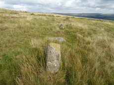
Notes: Not listed in NMR. Discovered by Lethbridge in 1992. Butler Vol. 3 Map 51.9. Oval cairn at the higher end. Orientated just west of north and 73.5 m from the cairn is a massive fallen longstone 2.7 m long which is probably the terminal stone of the row. There are 31 of 47 original stones visible in the row, all but a few either flat or leaning. Lethbridge p.59-61 diagram p.59, 61.
Nearby sites: SX59476314
Shell Top S.W. stone row Cairn
OS Map: SX 59460 63150
HER record: MDV131179
ShortName: CN:ShellTopSW
Butler map: 51.9
Nearby sites: SX59466315
Shell Top S.W. stone row Standing Stone
OS Map: SX 59420 63210
HER record: MDV131180
ShortName: SS:ShellTopSW
Butler map: 51.9
Notes: HER refering to Butler: Fallen longstone 2.7 metres long at the northern end of the stone row to the south-west of Shell Top.. The ngr is estimated from location of row and cairn.
Nearby sites: SX59426321
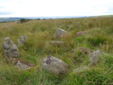
Shell Top Platform Cairn Circle
OS Map: SX 59766 63805
HER record: MDV12905
Megalithic Portal: 45646
PMD: Shell Top
Alternate name: Shell Top Summit 1 Platform Cairn Circle
ShortName: PC:ShellTopSu1
Butler map: 51.10.1
Grinsell: COR 1
Turner: E53
Notes: Cairn 9.5m in diameter with boulder of tor. Butler Vol 3 map 51.10 p.174.
Nearby sites: SX59776381
Shell Top Summit 2 Platform Cairn Circle
OS Map: SX 59902 63740
HER record: MDV12791
ShortName: PC:ShellTopSu2
Butler map: 51.10.2
Butler Vol 5: p.194 & Fig.138
Grinsell: COR 1b
Turner: E55
Notes: HER: Southern of three cairns on Shell Tor summit of 10.4 metres by 9.4 metres and 0.4 metres high
Nearby sites: SX59906374
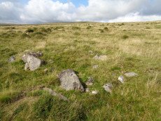
Shell Top Stone Ring Cairn Circle
OS Map: SX 59835 63835
HER record: MDV12790
Megalithic Portal: 1250
Alternate name: Shell Top Summit 3 Stone Ring Cairn Circle
ShortName: RC:ShellTopSu3
Butler map: 51.10.3
Grinsell: COR 1a
Turner: A44
Notes: "A stone ring 20.5m overall diameter, comprising small, heather covered stones, 0.8m wide and 0.2m high. It lies on the broad level summit of shell top at 475m above sea level. There is a wide 3m wide gap on the north side and the interior is slightly domed, about 0.4m high, possibly a natural rise since it is off-centre. The term 'stone circle' is rather a mis-nomer since only half a dozen stones protrude from the turf and in appearance it is simply a low circular bank."
Nearby sites: SX59846384
Rook Tor 1 Cairn Circle
OS Map: SX 61270 61480
HER record: MDV49463
Megalithic Portal: 3445
ShortName: CC:Rook Tor 1
Turner: G21
Notes: Turner G21: 10 stones standing, one a boulder (Turner). The closest possible NMR entry that could fit refers to natural boulders. Butler refers to a possible cairn at SX60236153 a semi-circle of slabs amongst the rocks of Rook Tor are obviously artificially set - remains suggest the site of a cairn, entirely demolished but for the retaining circle. (Butler Vol. 3. p.182). Are there two features separated by 1 km or is there an error in one of these grid references? See also: Rook Tor 2
Nearby sites: SX61276148
Rook Tor Cairn Circle
OS Map: SX 60230 61530
HER record: MDV132245
Megalithic Portal: 3445
Alternate name: Rook Tor 2 Cairn Circle
ShortName: CC:Rook Tor 2
Butler map: 52.8
Notes: Butler refers to a possible cairn at SX 6023 6153 a semi-circle of slabs amongst the rocks of Rook Tor are obviously artificially set - remains suggest the site of a cairn, entirely demolished but for the retaining circle. (Butler Vol. 3. p.182).
Turner lists a Rook Tor site (G21) 1km away at SX 6127 6148: 10 stones standing, one a boulder. Are there two seprate features or does one auth have the wrong grid reference? See also: Rook Tor 1
Nearby sites: SX60236153
Ranny Brook 22 Cairn
OS Map: SX 61930 63430
HER record: MDV43760
ShortName: CN-Ranny Bk 22
Butler map: 52.9
Notes: A mound at SX 61940 63452 (Garmin GPS) is possibly the Ranny Brook 22 Cairn that Butler Map 52.9 refers to as a hut having been converted into a cairn. Butler gives SX 6193 6343 as the location - there are many huts in very close proximity in this area so certain identification is a bit tricky. The closest hut in the HER is 43759 which is thought to be located at SX 61956 63442 which is 19 metres from this mound. The site in the HER is supposedly 7.5 metres in diameter. So in terms of location this would almost be close enough to touch this mound - so maybe the grid references are slightly out and they are the same site. However, currently it would require a further visit to be certain.
Nearby sites: SX61936343
Ranny Brook N.1 Clearance Cairn
OS Map: SX 62040 63430
HER record: MDV50926
ShortName: CN?Ranny Bk N1
Butler map: 52.9.1
Notes: Hut or cairn?
Nearby sites: SX62046343
Ranny Brook N.2 Reported Cairn
OS Map: SX 62170 63430
HER record: MDV4271
ShortName: CN?Ranny Bk N2
Butler map: 52.9.2
Grinsell: COR 11a
Barrow Report: 58
Notes: Hut or cairn? This retaining circle appears to be the possible remains of a hut circle. Vis=30/6/1976 (grinsell). Retaining circle or hut. Diameter 5m, height of stones 0.3m. Grinsell states that worth describes another circle of 6 stones adjoining the se of this circle. Vis=5/8/1977 (os). The remains of two hut circles at (approx) sx62186342 and sx62196343, both in poor condition. See also: Ranny Brook N2 (duplicate)
Nearby sites: SX62176343
Ranny Brook N2 (duplicate) Reported Cairn
OS Map: SX 62240 63430
HER record: MDV4271
ShortName: CNxRannyN2 Dup
Grinsell: COR 11b
Notes: This retaining circle appears to be the possible remains of a hut circle. Vis=30/6/1976 (grinsell). Retaining circle or hut. Diameter 5m, height of stones 0.3m. Grinsell states that worth describes another circle of 6 stones adjoining the se of this circle. Vis=5/8/1977 (os). The remains of two hut circles at (approx) sx62186342 and sx62196343, both in poor condition.
NB. Grinsell had two entries Cornwood 11a and 11b which are both covered in Ranny Brook N2. This record is here for completeness of Grinsell listings but is otherwise marked as a duplicate.
Nearby sites: SX62246343
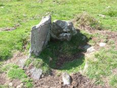
Ranny Brook (North of) Cist
OS Map: SX 62154 63547
HER record: MDV4272
Megalithic Portal: 45747
PMD: Ranny Brook settlement
Alternate name: Ranny Brook N.3 Cist
ShortName: CT Ranny Bk N3
Butler map: 52.9.3
DPD page: 65
Grinsell: COR 11
Barrow Report: 58
Notes: "The northern end-stone and the western side-stone survive, whilst smaller stones may represent the other sides. This agrees with Worth's survey, but in his report he has transposed north and south." Lethbridge diagram p.65 Cist 1. Butler Ranny Brook N. 3 (Cist 3) - Vol. 3. Map 52.9. (pp.184-7 general plan of Ranny Brook settlements and cairns p.184, diagram of cists p.186).
Nearby sites: SX62156355
Ranny Brook Cist
OS Map: SX 62616 63543
HER record: MDV4270
Megalithic Portal: 14987
PMD: Ranny Brook Head
Alternate name: Ranny Brookhead Cist
ShortName: CT Ranny Brook
Butler map: 52.10
DPD page: 66
Grinsell: COR 12
Barrow Report: 64 68 69 71
Notes: "Three sides of the grave are still in place; the third has been turned back and lies parallel to its original position. To the south of the cist, and about a foot away from the nearest point of the buried side-stone, lies the displaced coverstone. This stone has a greatest length of four feet and a greatest width of two feet six inches". Sides of cist sunken below surface. Lethbridge p.66. diagram p.65 Cist 2.Butler Ranny Brook Head - Vol. 3. Map 52.10 (diagram p.186).
Nearby sites: SX62626354
Ranny Brook (Yealm) Enclosed Settlement
OS Map: SX 62352 63670
HER record: MDV43608
Megalithic Portal: 45574
ShortName: ES:Ranny Brook
Notes: An enclosure of earth and stone walling 0.5m wide by 0.4m high encompasses an oval area 18.0m by 16.0m. It lies on the South facing slope to the North of Ranny Brook. Scheduled: Devon 10853.
Nearby sites: SX62356367
Coombe Brook E. Reported Cairn
OS Map: SX 62550 62510
HER record: MDV132246
ShortName: CN:CoombeBrook
Butler map: 52.11
Notes: Butler: "A common feature associated with the hut groups particularly on this part of the moor is a solitary cairn sited some distance uphill, usually just within sight, a too frequent occurrence for it to be coincidental".
Nearby sites: SX62556251
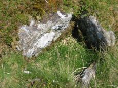
Harrowthorn (North of) Cist
OS Map: SX 62446 62645
HER record: MDV4269
Megalithic Portal: 45746
PMD: Harrowthorn Plantation
Alternate name: Coombe Brook N.E. Cist
ShortName: CT Harrowthorn
Butler map: 52.11
DPD page: 66
Grinsell: COR 15
Barrow Report: 58
Notes: "A cist lies 700 yards north of Harrowthorn Plantation and a few feet west of the track from Watercombe Moorgate to Ranny Brook. Only the two side stones and the eastern end stone remain. The structure is unusual in that the southern side stone is an earth fast boulder, an approximately vertical face of which forms a side of the cist." Lethbridge p.66. diagram p.65 Ranny Brook Cist 3. Butler Coombe Brook N.E. - Vol. 3. Map 52.11. Located 200m due east up hill of the Coome Brook enclosure.
Nearby sites: SX62456265
Yealm Steps Enclosed Settlement
OS Map: SX 62065 63607
HER record: MDV4273
Megalithic Portal: 45575
ShortName: ES Yealm Steps
Notes: "A fine example of enclosure and hut circles. Extensive prehistoric settlement area. Two villages contiguous, the larger pound a development of the smaller. Pound walls and those of huts consist of stone and turf. At least 22 huts within the enclosure. To the north and south of the pounds are scatters of isolated huts generally much larger than the enclosed huts. On the south there are remains of fields or paddocks. Rough moorland."
Nearby sites: SX62076361
Yealm Steps Reported Cist
OS Map: SX 61700 63700
HER record: MDV4367
PMD: Yealm Steps
ShortName: CT?Yealm Steps
Notes: The County Sites and Monument Record notes a cist at Ranny Brook. This may be an outlier of the Ranny Brook settlement,
Nearby sites: SX61706370
Harrowthorn Plantation N 1 Reported Cist
OS Map: SX 62404 62223
HER record: MDV4267
PMD: Harrowthorn Reave
ShortName: CN:Harrowthn 1
Butler map: 52.12
Grinsell: COR 16
Barrow Report: 64
Notes: This small round cairn, 4.7m in diameter and 0.6m high, lies on a gentle west facing slope at 305m above OD. It is constructed of small boulders, with a large slab, 160m by 115m., lying on the northeast side accompanied by a hollowed centre, 0.3m deep, suggesting a cist.
Nearby sites: SX62406222
Harrowthorn Plantation N 2 Reported Cist
OS Map: SX 62430 62240
HER record: MDV4268
ShortName: CN?Harrowthn 2
Grinsell: COR 17
Barrow Report: 64
Notes: Reported by RHW - not located by Grinsell. A turf covered cairn. Large slab of granite lies on north east side suggesting possible displaced capstone of cist.
Nearby sites: SX62436224
Harrowthorn Plantation N 3 Reported Cairn
OS Map: SX 62400 62200
HER record: MDV4268
ShortName: CN:Dendles 3
Nearby sites: SX62406220
Penn Beacon Cairn
OS Map: SX 59924 62928
HER record: MDV2404
Megalithic Portal: 45853
Alternate name: Penn Beacon Summit Cairn
ShortName: CN PennBeacon
Butler map: 52.14
Butler Vol 5: p.157 & Fig.96
Grinsell: COR 2
Barrow Report: 14
Notes: "A round cairn, 22 metres in diameter and 1.7 metres high, lies on the summit of Penn Beacon, at 430 metres above O.D. It is of small boulders and has been much disturbed, with a central hollow, 8 metres in diameter and 0.8 metres deep, and a modern marker cairn, 1 metre high, on the south side". Lethbridge p.62-3 suggests possible ruins of chambered cairn (diagram p.59).
Nearby sites: SX59926293
Penn Beacon 1 Cairn Circle & Cist
OS Map: SX 59532 62482
HER record: MDV12909
PMD: Penn Beacon 1
Alternate name: Penn Beacon 1 stone row Cairn Circle & Cist
ShortName: CT Penn Beac 1
Butler map: 52.14.1
DPD page: 61
Grinsell: COR 3
Notes: A cairn on the lower slope of Penn Beacon, close to stone row (sx56se/2). Opened in 1872 by Spence Bate and Oliver: a fine cist was found, a stone implement and many pot fragments, one quite substantial. The cairn stands at the north end of a double stone row which extends for 7.0m. The cist is not visible. See also: Bate's 1872 Report
Nearby sites: SX59536248

Penn Beacon S.W. Stone Row
OS Map: SX 59523 62471
HER record: MDV2399
Megalithic Portal: 2077
The Stone Rows of GB: Penn Beacon South West
PMD: Penn Beacon Cairn Stone Row
Alternate name: Penn Beacon SW Stone Row
ShortName: SR PennBeac SW
Butler map: 52.14.1
DPD page: 61
Notes: "A short double stone row 24ft. long and nearly 2ft. wide consisting of two pairs of stones on the southern slope of Penn Beacon. To the north end of the row there is a cairn approximately 52 feet in diameter and 6 foot high. It was excavated in 1872, a cist was discovered, though the capstone had collapsed at one end. Fragments of a wide mouthed jar were found and a slate implement, thought to be used for fashioning clay vessels". Lethbridge p.61 Penn Moor south double stone row and cairn - diagram p.59. See also: Bate's 1872 Report
Nearby sites: SX59526247
Penn Beacon S. Stone Row
OS Map: SX 59947 62553
HER record: MDV2400
Megalithic Portal: 2076
The Stone Rows of GB: Penn Beacon South
PMD: Penn Beacon Stone Row
Alternate name: Penn Beacon S Stone Row
ShortName: SR Penn Beac S
Butler map: 52.14
DPD page: 62
Notes: "A single stone row, sixty-six feet long, the largest stone being about 2 1/2 feet high. This row is no more than a remnant". Lethbridge p.62 Penn stone row - diagram p.59.
Nearby sites: SX59956255
Penn Beacon Platform Cairn Circle
OS Map: SX 59827 62268
HER record: MDV2402
Megalithic Portal: 45617
PMD: Penn Beacon 2
Alternate name: Penn Beacon S.2 Platform Cairn Circle
ShortName: PC:Penn Beac 2
Butler map: 52.14.2
Grinsell: COR 4
Turner: E7
Notes: A tumulus with a retaining circle, in poor condition. Diameter 12m, height 0.5m. "A cairn, about forty feet in diameter, from which almost all the stones have been removed and the central cist destroyed. It was surrounded by a circle of upright stones from one to three feet high, and to the west a row of two pairs of stones."
Nearby sites: SX59836227
Penn Beacon S.3 Reported Cairn
OS Map: SX 59830 62260
HER record: MDV132238
ShortName: CN:Penn Beac 3
Butler map: 52.14.3
Nearby sites: SX59836226
Penn Beacon S.4 Cairn
OS Map: SX 59797 62319
HER record: MDV12913
ShortName: CN:Penn Beac 4
Butler map: 52.14.4
Nearby sites: SX59806232
Penn Beacon S.W.5 Cairn
OS Map: SX 59590 62470
HER record: MDV132239
PMD: Penn Beacon 5
ShortName: CN:Penn Beac 5
Butler map: 52.14.5
Butler Vol 5: p.25 & Fig.6
Notes: Radcliffe corrects Butler's listing: The plan in Butler V p26 (Fig 7) refers to Penn Beacon 10. The plan for this site is Fig 6, p25, for which no cist is suggested. n.b. Following Radcliffe this has been corrected in this listing.
Nearby sites: SX59596247
Penn Beacon S.W.6 Cairn
OS Map: SX 59491 62658
HER record: MDV45312
ShortName: CN:Penn Beac 6
Butler map: 52.14.6
Notes: ?
Nearby sites: SX59496266
Penn Beacon S.W.7 Reported Cairn
OS Map: SX 59480 62570
HER record: MDV132240
ShortName: CN:Penn Beac 7
Butler map: 52.14.7
Notes: ?
Nearby sites: SX59486257
Penn Beacon S.W.8 Cairn
OS Map: SX 59490 62580
HER record: MDV132240
ShortName: CN:Penn Beac 8
Butler map: 52.14.8
Nearby sites: SX59496258
Penn Beacon S.W.9 Reported Cairn
OS Map: SX 59410 62580
HER record: MDV12914
ShortName: CN:Penn Beac 9
Butler map: 52.14.9
Nearby sites: SX59416258
Penn Beacon S.W.10 Reported Cist
OS Map: SX 59431 62663
HER record: MDV12915
PMD: Penn Beacon 10
ShortName: CN Penn Beac10
Butler map: 52.14.10
Butler Vol 5: p.26 & Fig.7
Notes: Cairn 10 survives as a ring of stones only, ten small slabs, several of them overgrown, arranged in a circle about 3.0m across. The upper edge of a narrow slab protruding through the turf near the centre is in the correct position for the end stone of a cist. (Butler Vol. 3 p.193) n.b. Radcliffe points out that Butler incorrectly lists Vol 5 Fig 6, p25 for this cairn, it has been corrected in this listing to Fig 7. p26
Nearby sites: SX59436266
Penn Beacon S.W.11 Reported Cairn
OS Map: SX 59340 62740
HER record: MDV132241
ShortName: CN:Penn Beac11
Butler map: 52.14.11
Nearby sites: SX59346274
Penn Beacon S.W.12 Reported Cairn
OS Map: SX 59360 62740
HER record: MDV132241
ShortName: CN:Penn Beac12
Butler map: 52.14.12
Notes: Butler: one of a pair (with cairn 11), "the companion mound a few metres uphill has been reduced to an oval shape by the removal of half of it's structure, the arc of stones foooting the upper part alone remaining".
Nearby sites: SX59366274
Penn Beacon W.13 Reported Cairn
OS Map: SX 59300 62870
HER record: MDV132242
ShortName: CN:Penn Beac13
Butler map: 52.14.13
Nearby sites: SX59306287
Penn Beacon W.14 Reported Cairn
OS Map: SX 59270 62940
HER record: MDV132243
ShortName: CN:Penn Beac14
Butler map: 52.14.14
Nearby sites: SX59276294
Penn Beacon W.15 Cairn
OS Map: SX 59210 63030
HER record: MDV12911
ShortName: CN:Penn Beac15
Butler map: 52.14.15
Notes: ?
Nearby sites: SX59216303
Penn Beacon W.16 Reported Cairn
OS Map: SX 59260 63010
HER record: MDV12911
ShortName: CN:Penn Beac16
Butler map: 52.14.16
Nearby sites: SX59266301
Penn Beacon W.17 Cairn
OS Map: SX 59200 62900
HER record: MDV12910
ShortName: CN:Penn Beac17
Butler map: 52.14.17
Notes: Many of the Butler Penn Beacon cairns could match HER 12910 - this one is closer!
Nearby sites: SX59206290
Penn Beacon SW Cairn
OS Map: SX 59580 62420
HER record: MDV48899
ShortName: CN:Penn BeacSW
Turner: A56
Notes: Stone ring encircling natural rock.24m in diameter with bank 1m wide and 0.3m high. Only a few boulders remain.
Nearby sites: SX59586242
South-west of Penn Beacon Enclosed Settlement
OS Map: SX 59763 62760
HER record: MDV2401
ShortName: ST:Penn BeacSW
Notes: Enclosure with hut circles on Cholwich Town contour reave.
Nearby sites: SX59766276
Penn Beacon 1 stone row (duplicate) Reported Cist
OS Map: SX 59528 62475
HER record: MDV2407
ShortName: CT:Penn Beac18
Butler map: 52.14.1
Notes: Duplicate of HER 12909
Nearby sites: SX59536248
Dendles Waste Ring Setting Cairn and Cist
OS Map: SX 61535 62804
HER record: MDV4276
Megalithic Portal: 45691
PMD: Dendles Waste
Alternate name: Dendles Waste S. Ring Setting Cairn and Cist
ShortName: CT Dendles 1
Butler map: 52.15
DPD page: 64
Grinsell: COR 14
Turner: D19
Barrow Report: 43
Notes: "The circle, consists of eight flat slabs, set on edge and has an internal diameter of approximately 3.4m. Some of the stones from the western quadrant of the circle are missing; a single earthfast stone is all that survives. The rectangular cist lies roughly centrally within the circle and is oriented E to W. It measures 1.2m long by 0.6m and 0.5m deep with slabs still in place both sides". Lethbridge diagram p.63, photo p.64. Butler Dendles Waste S. - Vol. 3. Map 52.15 (diagram p.194).
Nearby sites: SX61546280
Dendles Waste N. Reported Cairn
OS Map: SX 61500 62900
HER record: MDV132270
ShortName: CN?Dendles 2
Butler map: 52.15
Notes: Reported by Worth. Butler, Volume 3 p.194, says in relation to the cist He also recorded a second circle about 155m to the north, 10.7m in diameter with six stones standing and one displaced. This area hopelessly encumbered with tree roots and fallen branches, is too disturbed for any recognisable structure to have survived.
Nearby sites: SX61506290
Dendles Waste 3 Reported Cairn
OS Map: SX 61570 61820
HER record: MDV4278
ShortName: CNxDendles 3
Nearby sites: SX61576182
Dendles Waste 4 Reported Cairn
OS Map: SX 61620 61970
HER record: MDV4279
ShortName: CN:Dendles 4
Nearby sites: SX61626197
Dendles Waste 5 Reported Cairn
OS Map: SX 61640 61980
HER record: MDV4280
ShortName: CNxDendles 5
Nearby sites: SX61646198
Ford Waste Reported Cairn
OS Map: SX 60920 61850
HER record: MDV28102
ShortName: CN:FordWaste
Notes: Clearance cairn
Nearby sites: SX60926185
High-house Waste Enclosed Settlement
OS Map: SX 60500 62700
HER record: MDV4362
Megalithic Portal: 45579
ShortName: ES:HighHouse
DPD page: 63
Notes: "Scattered settlement of at least 12 circular huts, some of them being very large. Possibly Romano-British as opposed to the Bronze Age/Iron Age settlements nearby. Later rectangular house on south edge of area". Lethbridge p.63-64 Hut Circle with largest door jambs (over 4 foot tall) on Dartmoor.
Nearby sites: SX60506270
Parkland Reported Cairn
OS Map: SX 59200 61800
HER record: MDV120213
ShortName: CN:Parkland
Notes: HER: Features recorded in 1996 woodland survey, probable clearance cairns. Consist of large and small boulders and rocks; possible remains of earlier field boundaries; possibly prehistoric in origin.
Nearby sites: SX59206180
Watercombe Gate Reported Cairn
OS Map: SX 62510 61860
HER record: MDV132247
ShortName: CN?Watercombe
Butler map: 52.13
Notes: Butler: "Further downhill in the same direction a small oval cairn ... lies a short distance from the newtake wall". Not listed on NMR or HER.
Nearby sites: SX62516186
Stalldown (W) Platform Cairn Circle and Cist
OS Map: SX 62833 62327
HER record: MDV13234
Megalithic Portal: 45791
PMD: Stall Moor W.
Alternate name: Stalldown W.11 Platform Cairn Circle and Cist
ShortName: CT Stalldown W
Butler map: 54.18.11
DPD page: 67
Grinsell: COR 11c
Turner: E30
Notes: "This small round cairn, diameter 5.7 to 6.4m, height 0.5m, is built of small boulders ... It contains a cist, the south side stone, 1.2m long, both end stones, 0.4m long ...On the south side of the cairn 3 large stones, 0.8m to 1.0m long and set on edge are the probable remains of a kerb". Lethbridge pp.65-67. diagram p.65 Cist 4, photo p.67. Butler Stalldown W. (Cairn 11) - Vol. 4. Map 54.18.11 (p.61-2 diagram p.62).
Nearby sites: SX62836233
Cholwichtown Contour Reave Enclosed Settlement
OS Map: SX 59383 63449
HER record: MDV2435
ShortName: ST:Cholwich
Notes: Enclosure with hut circles on Cholwich Town contour reave.
Nearby sites: SX59386345
Penn Moor (N) Reported Cairn
OS Map: SX 60780 65000
HER record: MDV5127
ShortName: CN?Penn Moor1
Grinsell: COR 25
Notes: Grinsell: On SHAUGH PRIOR bdry. OS Archaeol. 15 May 1950: a turf covered mound. The HER entry MDV5127 refers to 9 mounds in very good condition being dominated by peat which may suggest peat stacks. Innumerable amorphous mounds, of natural formation lie on the summit of the ridge, adjacent to the position specified, and none can be distinguished as a 'tumulus', and it is possible that a natural feature has been misidentified.
Nearby sites: SX60786500
Shavercombe Head (9+ cairns) Reported Cairn
OS Map: SX 60650 64900
HER record: MDV5127
ShortName: CNxShavercom2
Butler map: 50.3
Notes: Nine circular mounds on high ground at Shavercombe Head. Each of these mounds looks like a barrow, but each is composed solely of peat and there are many other mounds in the vicinity suggesting that there is some form of natural or other agency causing this phenomena.
Around 1 km from this area of peat stacks are over 50 small mounds which are charcoal burning platforms, see: MDV132869: Charcoal burners platforms west of Yealm Head.
Nearby sites: SX60656490
Broadall Lake Cairnfield Master
OS Map: SX 61120 63100
HER record: MDV28127
ShortName: CN:Broadall
Notes: HER: Possible cairnfield associated with possible clearance for adjacent enclosures on NMR 1977 aerial image at SX 6112 6310.
Nearby sites: SX61126310
Harrowthorn Plantation Reported Stone Row
OS Map: SX 62520 61710
HER record: MDV13236
ShortName: SR:Harrow
Notes: HER: Supposed stone row (not an antiquity) ... Worth states they were moved to make a carriageway in 19th century: These were stones removed to one side of the track to allow a carriage to pass during the 19th century at the order of Lord Blatchford. The writer is very much mistaken in thinking this is a stone row
Nearby sites: SX62526171
Page last updated 10/12/24