
Guide to the Monuments on Homer Hill and Longstone Hill
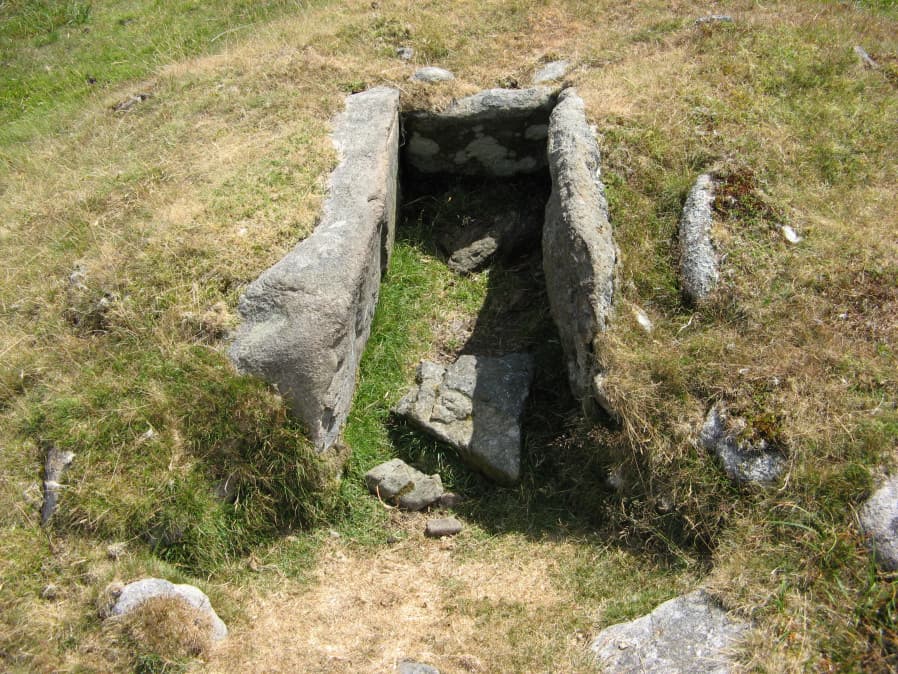
Table of Ritual and Burial Monuments on Homer Hill and Longstone Hill
The following table lists the records currently in this Guide Map. For an explantion of the Guide Maps and a table of all 62 Guide Maps, follow this link: Guide List Table. Introductory text will be added to each guide list in 2025. Notes on duplication and omissions will appear below the table once checks have been finalised.
Homer Hill and Longstone Hill Guide Map
Guidance for walkers: The monuments featured in this database are archaeological treasures and need to be protected and preserved - please do not disturb any sites. Please check access and firing times before visiting sites, not all sites listed are on open access land. Firing ranges and boundaries of open access areas are marked on the OL28 OS Dartmoor Explorer map. Please stick to the country code and consider giving support to the numerous agencies that help to keep Dartmoor a fabulous natural and historic environment!
List of Ritual and Burial Monuments on Homer Hill and Longstone Hill
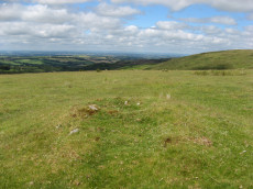
Longstone Hill (c.24) Cairnfield Master
OS Map: SX 56800 90800
HER record: MDV5577
ShortName: CN:Longstone M
Butler map: 42.8
Notes: HER: A cairnfield containing 39 small irregular cairns on the crest and upper slopes of Longstone Hill. The majority relate to stone clearance activity perhaps during a period when the area was considered suitable for cultivation or simply to gather stone for use elsewhere. Features were recorded and scheduled in 1994 as a Bronze Age cairnfield. Ground survey in 2004 shed doubt on this identification and suggests these are clearance cairns.
This record has been separated out into individual entries, hence marked as a duplicate. It is the master record.
Nearby sites: SX56809080
Longstone Hill 1 Cairn
OS Map: SX 56606 91132
HER record: MDV5574
ShortName: CN:Longstone 1
Butler map: 42.8.1
Notes: HER: Two possible prehistoric clearance cairns. Both mounds are sub-circular in shape. The western mound measures 6m in diameter and stands up to 1.1m high on the downslope side and 0.3m high on the upslope, whilst the eastern mound measures 5m in diameter, 0.3m high on the downslope and 0.2m high on the upslope. Many of the mounds within the cairnfield are crest sited and are therefore clearly visible from long distances to the east and west. This situation strongly suggests that many of the cairns probably contain burials, although the size and shape of some mounds suggests that some may also be associated with stone clearance connected with cultivation of the area.
Nearby sites: SX56619113
Longstone Hill 2 Cairn
OS Map: SX 56691 91140
HER record: MDV5575
ShortName: CN:Longstone 2
Butler map: 42.8.2
Notes: HER: A disturbed cairn on the level summit of Longstone Hill 60m east of the flagstaff. The circular cairn measures 9.4m in diameter and stands 0.4m high.
Nearby sites: SX56699114
Longstone Hill 3 Cairn
OS Map: SX 56787 91355
HER record: MDV20564
ShortName: CN:Longstone 3
Butler map: 42.8.3
Notes: HER: The mound is sub-circular in shape, measures 6.2m in diameter and stands up to 1.2m high on the downslope side and 0.5m high on the upslope. Many of the mounds within the cairnfield are crest sited and are therefore clearly visible from long distances to the east and west. This situation strongly suggests that many of the cairns probably contain burials, although the size and shape of some mounds suggests that some may also be associated with stone clearance connected with cultivation of the area.
Nearby sites: SX56799136
Longstone Hill 4 Cairn
OS Map: SX 56801 90697
HER record: MDV52484
ShortName: CN:Longstone 4
Butler map: 42.8.4
Notes: HER: Four cairns were recorded at this location in 1994 situated on the ridge south of Longstone Hill forming part of a cairnfield. Possibly prehistoric clearance cairns.
Nearby sites: SX56809070
Longstone Hill 5 Cairn
OS Map: SX 56750 90650
HER record: MDV52485
ShortName: CN:Longstone 5
Butler map: 42.8.5
Notes: HER: Both mounds are sub-circular in shape and these measure 2.8 metres and 4 metres in diameter and stand 0.2 metres and 0.4 metres high. A hollow in the north eastern side of the southern mound suggests partial early excavation or robbing. Many of the mounds within the cairnfield are crest sited and are therefore clearly visible from long distances to the east and west. This situation strongly suggests that many of the cairns probably contain burials, although the size and shape of some mounds suggests that some may also be associated with stone clearance connected with cultivation of the area.
Nearby sites: SX56759065
Longstone Hill 6 Cairn
OS Map: SX 56726 90762
HER record: MDV52486
ShortName: CN:Longstone 6
Butler map: 42.8.6
Notes: HER: The mound is sub-circular in shape, measures 4m in diameter and stands up to 0.35m high. A hollow in the centre of the mound suggests partial early excavation or robbing. Many of the mounds within the cairnfield are crest sited and are therefore clearly visible from long distances to the east and west. This situation strongly suggests that many of the cairns probably contain burials, although the size and shape of some mounds suggests that some may also be associated with stone clearance connected with cultivation of the area.
Nearby sites: SX56739076
Longstone Hill 7 Cairn
OS Map: SX 56684 90617
HER record: MDV52487
ShortName: CN:Longstone 7
Butler map: 42.8.7
Notes: HER: Possible prehistoric clearance cairn. Feature is sub-circular in shape, 4.5 metres in diameter standing up to 0.9 metres high on the downslope side and 0.3 metres high on the upslope. Many of the cairns within the group are crest sited, strongly suggesting that many probably contain burials, although the size and shape of some mounds suggests that some may also be associated with stone clearance
Nearby sites: SX56689062
Longstone Hill 8 Cairn
OS Map: SX 56745 90399
HER record: MDV52488
ShortName: CN:Longstone 8
Butler map: 42.8.8
Notes: HER quoting Gerrard:
Two cairns. The northern mound (at SX 56749040) is oval, 5m by 4m, stands up to 0.4m high and is aligned east-west. The southern mound (at SX 56749039) is sub-circular, 8m in diameter and stands up to 0.6m high.
Nearby sites: SX56759040
Longstone Hill 9 Cairn
OS Map: SX 56724 90352
HER record: MDV52489
ShortName: CN:Longstone 9
Butler map: 42.8.9
Notes: HER quoting Gerrard: SX56729035 Southernmost cairn forming part of a cairnfield of at least 64 mounds. Sub-circular in shape, 4.5m in diam and up to 0.7m high (mpp).
Newman: There is no ground evidence in the area described by the grid reference to suggest the presence of a cairn. The cairnfield described in 1994 (1393516) commences some 300m to the north. Suspect grid reference.
Nearby sites: SX56729035
Longstone Hill 10 Cairn
OS Map: SX 56601 90695
HER record: MDV52491
ShortName: CN:Longstone10
Butler map: 42.8.10
Notes: HER: Three possible prehistoric clearance cairns. All three are sub-circular, between 3.4m and 4m in diameter and up to between 0.5m and 0.8m high. Many of the cairns within the group are crest sited, strongly suggesting that many of the cairns probably contain burials, although the size and shape of some mounds suggests that some may also be associated with stone clearance
Nearby sites: SX56609070
Longstone Hill 11 Cairn
OS Map: SX 56533 90750
HER record: MDV52492
ShortName: CN:Longstone11
Butler map: 42.8.11
Notes: HER: Three cairns forming part of a cairnfield of at least 64 mounds. Two of the mounds are sub-circular. The north and south cairns measure 2.5 metres in diameter. The third cairn is ovoid in shape, is aligned east-west and measures 4.0 metres by 2.0 metres.
Nearby sites: SX56539075
Longstone Hill 12 Cairn
OS Map: SX 56824 90963
HER record: MDV52493
ShortName: CN:Longstone12
Butler map: 42.8.12
Notes: HER: The northern mound measures 4.3m in diameter and stands 1m high on the downslope side and 0.3m high on the upslope. The southern mound measures 3.2m in diameter and stands up to 0.5m high. Many of the mounds within the cairnfield are crest sited and are therefore clearly visible from long distances to the east and west. This situation strongly suggests that many of the cairns probably contain burials, although the size and shape of some mounds suggests that some may also be associated with stone clearance connected with cultivation of the area.
Nearby sites: SX56829096
Longstone Hill 13 Cairn
OS Map: SX 56777 90969
HER record: MDV52494
ShortName: CN:Longstone13
Butler map: 42.8.13
Notes: HER: The northern mound measures 4.3m in diameter and stands up to 0.7m high. The southern mound, which has seen limited damage as a result of a track cutting through the western edge, measures 4.2m in diameter and stands up to 0.7m high. Many of the mounds within the cairnfield are crest sited and are therefore clearly visible from long distances to the east and west. This situation strongly suggests that many of the cairns probably contain burials, although the size and shape of some mounds suggests that some may also be associated with stone clearance connected with cultivation of the area.
Nearby sites: SX56789097
Longstone Hill 14 Cairn
OS Map: SX 56803 91237
HER record: MDV52495
ShortName: CN:Longstone14
Butler map: 42.8.14
Notes: HER: The mound is sub-circular in shape, measures 5m in diameter and stands up to 0.7m high. Many of the mounds within the cairnfield are crest sited and are therefore clearly visible from long distances to the east and west. This situation strongly suggests that many of the cairns probably contain burials, although the size and shape of some mounds suggests that some may also be associated with stone clearance connected with cultivation of the area.
Nearby sites: SX56809124
Longstone Hill 15 Cairn
OS Map: SX 56771 91277
HER record: MDV52496
ShortName: CN:Longstone15
Butler map: 42.8.15
Notes: HER: Two of the mounds are sub-circular in shape, and these measure 3.2m in diameter by 0.6m high and 3.8m in diameter by 0.4m high. The remaining mound is oval in shape, is aligned NNW to SSE, measures 4m long by 2.3m wide and stands up to 0.3m high. Many of the mounds within the cairnfield are crest sited and are therefore clearly visible from long distances to the east and west. This situation strongly suggests that many of the cairns probably contain burials, although the size and shape of some mounds suggests that some may also be associated with stone clearance connected with cultivation of the area.
Nearby sites: SX56779128
Longstone Hill 16 Cairn
OS Map: SX 56729 90976
HER record: MDV52497
ShortName: CN:Longstone16
Butler map: 42.8.16
Notes: HER: The mound is sub-circular in shape, measures 3m in diameter and stands up to 0.2m high. Many of the mounds within the cairnfield are crest sited and are therefore clearly visible from long distances to the east and west. This situation strongly suggests that many of the cairns probably contain burials, although the size and shape of some mounds suggests that some may also be associated with stone clearance connected with cultivation of the area.
Nearby sites: SX56739098
Longstone Hill 17 Cairn
OS Map: SX 56664 91015
HER record: MDV52498
ShortName: CN:Longstone17
Butler map: 42.8.17
Notes: HER: The western mound measures 4.5m in diameter and stands up to 0.4m high, whilst the eastern mound measures 5.5m in diameter and 0.3m high. Many of the mounds within the cairnfield are crest sited and are therefore clearly visible from long distances to the east and west. This situation strongly suggests that many of the cairns probably contain burials, although the size and shape of some mounds suggests that some may also be associated with stone clearance connected with cultivation of the area.
Nearby sites: SX56669102
Longstone Hill 18 Cairn
OS Map: SX 56702 91080
HER record: MDV52499
ShortName: CN:Longstone18
Butler map: 42.8.18
Notes: HER: Possible prehistoric clearance cairn. Sub-circular, 4.2m in diameter and up to 0.3m high. A central hollow, 1m square by 0.2m deep, suggests partial early excavation or robbing.
Nearby sites: SX56709108
Longstone Hill 19 Cairn
OS Map: SX 56597 91072
HER record: MDV52500
ShortName: CN:Longstone19
Butler map: 42.8.19
Notes: HER: Four possible prehistoric clearance cairns - part of MDV5577. Gerrard (1994) records four possible cairns forming part of a cairnfield. Three are sub-circular; The remaining mound is ovoid. 2004 survey identified two of the four in vicinity.
Nearby sites: SX56609107
Longstone Hill 20 Cairn
OS Map: SX 56566 91105
HER record: MDV52501
ShortName: CN:Longstone20
Butler map: 42.8.20
Notes: HER: The mound is sub-circular in shape, measures 5m in diameter and stands up to 0.9m high on the downslope side and 0.3m high on the upslope. Many of the mounds within the cairnfield are crest sited and are therefore clearly visible from long distances to the east and west. This situation strongly suggests that many of the cairns probably contain burials, although the size and shape of some mounds suggests that some may also be associated with stone clearance connected with cultivation of the area.
Nearby sites: SX56579111
Longstone Hill 21 Cairn
OS Map: SX 56654 91197
HER record: MDV52502
ShortName: CN:Longstone21
Butler map: 42.8.21
Notes: HER: Two possible prehistoric clearance cairns. The northern mound measures 6.5 metres in diameter and stands up to 1 metres on the downslope side and 0.4 metres high on the upslope. The southern mound measures 2.5 metres in diameter and 0.2 metres high.
Nearby sites: SX56659120
Longstone Hill 22 Cairn
OS Map: SX 56673 91252
HER record: MDV52503
ShortName: CN:Longstone22
Butler map: 42.8.22
Notes: HER: Two of the mounds are ovoid in shape, are aligned north west to south east and measure respectively 3.5m long, 2.2m wide and 0.5m high, and 8m long, 4m wide and 0.8m high. The third mound is sub-circular, measures 5.7m in diameter and stands 1.1m high on the downslope side and 0.3m high on the upslope. Many of the mounds within the cairnfield are crest sited and are therefore clearly visible from long distances to the east and west. This situation strongly suggests that many of the cairns probably contain burials, although the size and shape of some mounds suggests that some may also be associated with stone clearance connected with cultivation of the area.
Nearby sites: SX56679125
Longstone Hill 23 Cairn
OS Map: SX 56751 91328
HER record: MDV52504
ShortName: CN:Longstone23
Butler map: 42.8.23
Notes: HER: The mound is sub-circular in shape, measures 3m in diameter and stands up to 0.3m high. Many of the mounds within the cairnfield are crest sited and are therefore clearly visible from long distances to the east and west. This situation strongly suggests that many of the cairns probably contain burials, although the size and shape of some mounds suggests that some may also be associated with stone clearance connected with cultivation of the area.
Nearby sites: SX56759133
Longstone Hill 24 Cairn
OS Map: SX 56714 91291
HER record: MDV52505
ShortName: CN:Longstone24
Butler map: 42.8.24
Notes: HER: The mound is sub-circular in shape, measures 3m in diameter and stands up to 0.3m high. Many of the mounds within the cairnfield are crest sited and are therefore clearly visible from long distances to the east and west. This situation strongly suggests that many of the cairns probably contain burials, although the size and shape of some mounds suggests that some may also be associated with stone clearance connected with cultivation of the area.
Nearby sites: SX56719129
Longstone Hill 25 Cairn
OS Map: SX 56791 90896
HER record: MDV52506
ShortName: CN:Longstone25
Butler map: 42.8.25
Notes: HER: Possible prehistoric clearance cairn. Cairn is sub-circular in shape, measures 4.7m in diameter and stands up to 0.5m high. A hollow in the centre of the mound suggests partial early excavation or robbing.
Nearby sites: SX56799090
Longstone Hill S. Cairn
OS Map: SX 56909 90553
HER record: MDV52507
ShortName: CN:Longstone S
Butler map: 42.9
Notes: HER: A very disturbed cairn on Longstone Hill. The mound measures 8.7 metres north-south by 8.3 metres and stands a maximum of 1.0 metres high on its west side. The western half of the interior is occupied by two amorphous hollows, which appear to be unrecorded antiquarian excavations. Spoil from these features has been deposited on the southern flank of the cairn. There is no evidence to suggest the presence of a kerb or cist.
Nearby sites: SX56919055
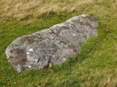
Longstone Hill Standing Stone
OS Map: SX 56725 90890
HER record: MDV5571
Megalithic Portal: 36422
PMD: Longstone Hill Standing Stone
ShortName: SS Longstone
Butler map: 42.
Butler Vol 5: p.220
DPD page: 156
Notes: Possible recumbent longstone on summit of Longstone Hill, east of Meldon Reservoir. Suggested as possible menhir by Butler and Newman. Historic England:A sinuous 50 metres long, 2 metres wide and 0.25 metres high bank lying within the monument leads towards a large recumbent stone. This stone measures 1.75 metres long, 0.8 metres wide and 0.45 metres thick and is the only large stone visible on Longstone Hill. It has been suggested that this may be the longstone which once stood upright to give the hill its name. The presence of this stone, which would have been broadly contemporary with the cairns, provides additional support for the ritual and funerary character ascribed to many cairns within the group.
Nearby sites: SX56739089
Homerton Hill (c.20) Cairnfield Master
OS Map: SX 56100 90500
HER record: MDV12886
ShortName: CN:Homerton M
Butler map: 43.15
Notes: HER: Remains include a hut circle, lengths of turf-covered stony bank forming part of the associated field system which covers an area of approximately 2.0 hectares and at least twenty small clearance cairns. Several of the clearance cairns appear to have been confused with sepulchral monuments in the past and display shallow delvings in their tops. When combined with the incomplete nature of the field system the cairns suggest that the phase of enclosure in this area occurred in the later Prehistoric period and remained unfinished. Somewhat unusually for Dartmoor the field system encloses an earlier prehistoric ring cairn.
This is the master record for a cairn cemetery and as such set as a duplicate record. See individual entries.
Nearby sites: SX56109050
Homerton Hill 1 Cairn
OS Map: SX 56230 90370
HER record: MDV52470
ShortName: CN:Homerton 1
Notes: HER: Two circular cairns and an ovoid cairn lie within an enclosure, forming part of a cairnfield on Homerton Hill. The two circular mounds measure 4 metres and 6.3 metres in diameter and stand up to 0.4 metres and 0.7 metres high respectively. The larger mound has a central hollow, measuring 2.3 etresm by 1.2 metres by 0.15 metres deep, suggesting that it has been robbed or partially excavated. A length of lynchet measuring 1 metre wide and 0.3 metres high leads from the large cairn to a nearby ring cairn. The ovoid cairn is aligned east-west and measures 4.7 metres by 2.3 metres by 0.4 metres high.
Nearby sites: SX56239037
Homerton Hill 2 Cairn
OS Map: SX 56221 90545
HER record: MDV134924
ShortName: CN:Homerton 2
Notes: HER: Cairn within cairnfield on Homerton Hill. The cairn is ovoid in shape and measures 5.9 metres long, 3.9 metres wide and stands up to 0.5 metres high. It forms part of a group of mounds which most likely represents stone clearance connected with cultivation of the area.
Nearby sites: SX56229055
Homerton Hill 3 Cairn Circle
OS Map: SX 56220 90370
HER record: MDV52472
ShortName: CN:Homerton 3
Notes: HER: Possible ring cairn of 9.5 metres diameter lies on the crest of Homerton Hill. The enclosing bank on the south side is 2.4 metres wide by 0.4 metres high. This feature has been incorporated into a later field system, also associated with a hut circle and several clusters of clearance cairns some of which have been Scheduled.
Nearby sites: SX56229037
Homerton Hill 4 Cairn
OS Map: SX 56160 90320
HER record: MDV52473
ShortName: CN:Homerton 4
Notes: HER: group of seven cairns of between 3 metres and 5.7 metres diameter by between 0.8 metres and 1.1 metres high forming part of the cairn cemetery on Homerton Hill
Nearby sites: SX56169032
Homerton Hill 5 Cairn
OS Map: SX 56082 90546
HER record: MDV52474
ShortName: CN Homerton 5
Notes: HER: this cairn forms the westernmost mound in a cairnfield. Measures 5m in diam and stands up to 0.4m high. The s part of the mound has seen limited damage, probably as a result of partial robbing and the core of large stones is therefore exposed. This cairn may contain burials, but the mound does form part of a group which most likely represent stone clearance connected with cultivation of the area
Nearby sites: SX56089055
Homerton Hill 6 Cairn
OS Map: SX 56130 90450
HER record: MDV52475
ShortName: CN:Homerton 6
Notes: HER: This cairn forms an outlying part of a cairnfield. Cairn measures 4 metres in diameter and stands up to 0.2 metres high. The north-western part of the mound has seen limited damage, probably as a result of partial robbing. This cairn may contain burials, but the mound does form part of a group which most likely represent stone clearance connected with cultivation of the area.
Nearby sites: SX56139045
Homerton Hill 7 Cairn
OS Map: SX 56150 90500
HER record: MDV5578
ShortName: CN:Homerton 7
Notes: Update 31/12/2022: This record was previously associated with HER record MDV52476 which has been deleted. This record has now been linked to MDV5578 and the NGRs updated accordingly.
HER: Cairn of 4 metres diameter by up to 0.7 metres high forming part of a cairnfield on Homerton Hill. A shallow central hollow, 0.7 metres by 0.4 metres by 0.1 metres deep, suggests robbing or partial early excavation. This cairn may contain burials, but the mound does form part of a group which most likely represent stone clearance connected with cultivation of the area
Nearby sites: SX56159050
Homerton Hill 8 Cairn
OS Map: SX 56217 90570
HER record: MDV52478
ShortName: CN Homerton 8
Notes: HER: Cairn forming part of a cairnfield on Homerton Hill. The cairn is ovoid in shape and measures 5.9 metres long, 3.9 metres wide and stands up to 0.5 metres high. The mound forms part of a group which most likely represents stone clearance connected with cultivation of the area.
Nearby sites: SX56229057
Homerton Hill 9 Cairn
OS Map: SX 56268 90541
HER record: MDV52479
ShortName: CN:Homerton 9
Notes: HER: This cairn forms an outlying part of a cairnfield. The cairn measures 4.3 metres in diameter and stands up to 0.3 metres high. This cairn forms part of a group of mounds which most likely represents stone clearance connected with cultivation of the area.
Nearby sites: SX56279054

Homerton Hill N. Cist
OS Map: SX 56132 90651
HER record: MDV12884
Megalithic Portal: 45808
PMD: Homerton Hill
ShortName: CT Homerton N
Butler map: 43.15
Butler Vol 5: p.177 & Fig.119
DPD page: 157
Notes: Butler Homerton Hill N. Vol. 2. Map 43.15 (diagram Vol. 5. p.177). A small, disturbed cairn containing three edge set stones of a cist ... The turf covered cairn measures 3.5 x 3.1m and 0.3m max. height. The top and north side of the mound has been disturbed exposing the three in situ cist stones. The cist measures 0.8 x 0.6m and 0.3mdeep. It is now open to the north. A large stone lying flush with the ground lies immediately north east of the cairn and probably represents the missing endstone or the coverstone. Lethbridge diagram p.156 and photos p157.
Nearby sites: SX56139065
Homerton Hill S. Cairn
OS Map: SX 56409 90182
HER record: MDV103577
ShortName: CN Homerton S
Butler map: 43.15
Notes: HER: Cairn 300 metres to the south of the cairnfield on Homerton Hill. The turf covered mound measures 15 metres in diameter by up to 0.6 metres high
Nearby sites: SX56419018
South Down 1 Reported Cairn
OS Map: SX 55870 91400
HER record: MDV12883
ShortName: CN:SouthDown 1
Notes: Presumed prehistoric cairn on the north end of South Down
Nearby sites: SX55879140
South Down 2 Reported Cairn
OS Map: SX 55600 91200
HER record: MDV12885
ShortName: CN:SouthDown 2
Notes: HER: ne of a pair of cairns on South Down, west of Meldon Reservoir.
Nearby sites: SX55609120
South Down 3 Reported Cairn
OS Map: SX 55601 91239
HER record: MDV12887
ShortName: CN:SouthDown 3
Notes: NGR for this record is taken from an apparent matching feature on LIDAR. HER: one of a pair of cairns on South Down, west of Meldon Reservoir..
Nearby sites: SX55609124
South Down 4 Reported Cairn
OS Map: SX 55530 91120
HER record: MDV27374
ShortName: CN:SouthDown 4
Notes: HER: Barrow on south-west slope of South Down visible on RAF 1947 aerial image at SX 5553 9112.
Nearby sites: SX55539112
Page last updated 10/12/24