
Guide to the Monuments on Cripdon Down and Hayne Down

Table of Ritual and Burial Monuments on Cripdon Down and Hayne Down
The following table lists the records currently in this Guide Map. For an explantion of the Guide Maps and a table of all 62 Guide Maps, follow this link: Guide List Table. Introductory text will be added to each guide list in 2025. Notes on duplication and omissions will appear below the table once checks have been finalised.
Notes on possible duplications and omissions
Hayne Down summit Reported Cist: This is Grinsell MANATON 3a and Butler Map 21 - feature originates with description by Crossing. This record is included here to complete the Grinsell and Butler listings but the feature cannot be found. LVG and GMS have searched in vain for cist near reave connecting Bowerman's Nose with tor to SE, mentioned by Crossing 1912/1965, 294. Grinsell: LVG and GMS have searched in vain for cist near reave connecting Bowerman's Nose with tor to SE, mentioned by Crossing 1912/1965 p.294. The HER has an entry MDV130870 for Hayne Down Stone Row. That entry refers also to the reported Crossing cist but based on Crossing's description the two features are nearly 0.5km apart. For that reason we have kept the two records separate. It may not be worth the HER having a seprate entry.PS. These notes are to assist untangling complicated records and are neither permanent nor a criticism of the HER who do a fantastic job! The author finds it easier to systematically work through these records (2000+ of them) and add these notes, which are then to be communicated with the HER, if appropriate, it is a pragmatic way of dealing with lots of data without continually stopping and starting.
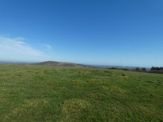
Cripdon Down and Hayne Down Guide Map
Guidance for walkers: The monuments featured in this database are archaeological treasures and need to be protected and preserved - please do not disturb any sites. Please check access and firing times before visiting sites, not all sites listed are on open access land. Firing ranges and boundaries of open access areas are marked on the OL28 OS Dartmoor Explorer map. Please stick to the country code and consider giving support to the numerous agencies that help to keep Dartmoor a fabulous natural and historic environment!
List of Ritual and Burial Monuments on Cripdon Down and Hayne Down
Heatree Down Cairn
OS Map: SX 72435 80255
HER record: MDV8764
ShortName: CN:HeatreeDown
Butler map: 20.19
Grinsell: MAN 3
Notes: Cairn on Heatree Down, measuring 14.5 meters in diameter, and 0.6 meters high. The cairn itself has been disturbed by looting and is bumpy.
Nearby sites: SX72448026
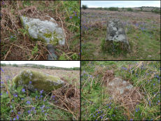
Hayne Down Stone Row
OS Map: SX 74022 79974
HER record: MDV130870
ShortName: SR Hayne Down
Notes: Cunis, E, 2021, (HER Correspondence). (04/03/2021) Possible cairn(s) and small stone row identified on Hayne Down. William Crossing mentions a cist 'near the southern group of summit rocks’ (reported by Butler in Vol. One) but cairn not mentioned therefore this may be a separate feature.
One stone standing prominently, another 2-3 noted in a linear arrangement from what looks like a round cairn at the north-western end. Grid Ref: SX74022 79974.
Nearby sites: SX74027997
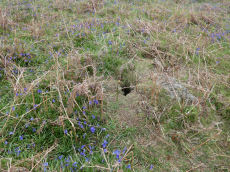
Hayne Down stone row Cairn
OS Map: SX 74025 79969
HER record: MDV130870
ShortName: CN HayneRow
Notes: Cairn at NW end of the Hayne Down stone row. It is a disturbed small mound. At the time of the authors visit it had an animal hole in it which is perhaps a sign of loose soil.
Nearby sites: SX74037997
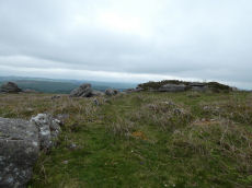
Hayne Down Passageway
OS Map: SX 74425 80126
HER record: MDV8801
ShortName: PW HayneDn
Butler map: 21.1
Butler Vol 5: p.85 & Fig.49
Notes: Butler: Prehistoric settlement on Hayne Down includes a passageway which winds through the rocks and seems deliberately designed to give the only access across the ridge. Bounded by close-set slabs and natural rocks this Bronze Age road is about 200 metres long by 2 metres wide and unusually open at both ends. One side forms the southern boundary of a large Prehistoric field occupied by two huts alongside the opposite wall, one of them built into the bank of a small D-shaped enclosure. A passageway along the edge of the field here stops well short of the enclosure, which was entered next to the hut between a still visible pair of slabs set across the bank. This is the only one of the six passageways on Hayne Down which leads in the direction of a hut, the others providing access between fields. The other hut of 4.6 metres diameter lies a few metres uphill. The barrier continues south-east from the summit rocks as a slab wall. A square enclosure is built on to the reave. Other details: Map 21, Site 2.
Nearby sites: SX74438013
Hayne Down summit Reported Cist
OS Map: SX 74400 80200
HER: No record found
PMD: Hayne Down
ShortName: CT?Hayne Down
Butler map: 21.
Grinsell: MAN 3a
Notes: Grinsell: LVG and GMS have searched in vain for cist near reave connecting Bowerman's Nose with tor to SE, mentioned by Crossing 1912/1965 p.294.
The HER has an entry MDV130870 for Hayne Down Stone Row. That entry refers also to the reported Crossing cist but based on Crossing's description the two features are nearly 0.5km apart. For that reason we have kept the two records separate.
Nearby sites: SX74408020
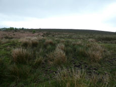
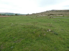
Cripdon Down Reported Stone Row
OS Map: SX 73362 80749
HER record: MDV130912
PMD: Cripdon Down
ShortName: SR Cripdon
Notes: HER: Hemery (1983) records a stone row here, estimated at SX 735 808. Stone row, Cripdon Down. North-west of the hut circles depicted on the Ordnance Survey map (SX 78 SW 17) and west of the Cripdon Down summit pile is a single stone row, 120 yards long passing over the crest of the Down. At the northern end is a very large fallen slab (destroyed cist?). The lower, southern end has stones of a greater size than the majority, one 7 feet long could have former a blocking stone. The stones are evenly spaced and not generally large.
Nearby sites: SX73368075
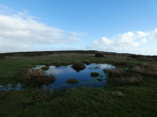
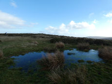
Cripdon Ancient Pool
OS Map: SX 73345 80335
HER record: MDV127204
ShortName: PO:Cripdon
Notes: "The pool at Cripdon measures 24 by 14m One of over 40 such 'sacred' pools identified on Dartmoor that are thought to have potentially been designed during the prehistoric period"
Nearby sites: SX73358034
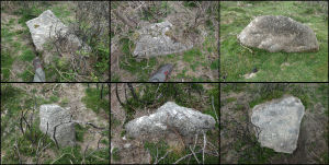
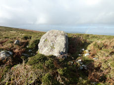
Cripdon Down Reported Cairn
OS Map: SX 73852 80032
HER: No record found
ShortName: CN CripdonDn
Notes: A possible cairn not far from the road on Cripdon Down. There is no entry for a cairn at this location on the HER but there is an entry for a Wind Pump. HER: 'wind pump' shown on os 6" (1963) map. See: MDV31033. Perhaps this could be the foundations for such a structure but it looks very much like a cairn!
Nearby sites: SX73858003
Easdon A Ancient Pool
OS Map: SX 73212 82349
HER record: MDV127207
ShortName: PO Easdon A
Notes: "Easdon A measures 12.5 by 10m One of over 40 such 'sacred' pools identified on Dartmoor that are thought to have potentially been designed during the prehistoric period"
Nearby sites: SX73218235
Easdon B Ancient Pool
OS Map: SX 73222 82334
HER record: MDV127208
ShortName: PO Easdon B
Notes: "A pool measuring 9 by 6.5m. One of over 40 such 'sacred' pools identified on Dartmoor that are thought to have potentially been designed during the prehistoric period. Lies near a reave."
Nearby sites: SX73228233
Easdon Hill Stone Ring Cairn Circle
OS Map: SX 73358 82318
HER record: MDV8767
Megalithic Portal: 45848
PMD: Easdon Tor
ShortName: RC Easdon Hill
Butler map: 22.3
Grinsell: MAN 1
Turner: A61
Notes: HER: A cairn with a large centrally placed rock which is possibly the capstone of a kist. Robbers have excavated around and about this giving a rock strewn central hollow to the cairn. There is no encircling ditch. The capstone is approximately square. Touching its base at the east is a triangular shaped orthostat. The cairn is situated on the very summit of a hill.. HER referring to Turner: Turner identifies this site as a ring cairn. Internal diameter 6 metres, with bank 2.5 metres wide and 1 metre high ... Encircles a natural boulder, 2.8 metres wide, 1.6 metres thick and up to 2.5 metres high. Reave on north-western side.
Nearby sites: SX73368232
Easdon Down 1 Crop Mark
OS Map: SX 74140 82610
HER record: MDV27974
ShortName: CNxEasdon Do1
Notes: Aerial Photograph
Nearby sites: SX74148261
Easdon Down 2 Crop Mark
OS Map: SX 73190 81360
HER record: MDV27977
ShortName: CNxEasdon Do2
Notes: Aerial Photograph
Nearby sites: SX73198136
Hunters Tor Fort
OS Map: SX 76158 82443
HER record: MDV8824
Megalithic Portal: 7759
ShortName: FT HuntersTor
Notes: "Iron Age hill-fort at Hunters' Tor: 'Three concentric enclosures, defences stone built and partly robbed for field walls. Inner entrance knobbed with embanked approach-road across second enclosure. Hill-top site.'"
Nearby sites: SX76168244

Houndtor Wood Fort
OS Map: SX 76838 80541
HER record: MDV8828
Megalithic Portal: 7759
ShortName: FT HoundtorWd
Notes: HER: Earthworks at Houndtor Wood. Possibly an unfinished and badly sited promontory fort. Single ditch and bank covering a portion of the promontory. In a wood recently replanted with conifers. To the north-west and south-east the defences end in natural ground contour. A simple causewayed entrance is visible, no form of outer defences were discovered. Ideal situation to cover valley of River Bovey to the south and also good visibility to the east but overlooked by a crest to the immediate north. No surface finds nor signs of habitation but adequate water supply is available. Site covered under deep winter fern.
Nearby sites: SX76848054
Hunters Tor (SE of) Reported Cist
OS Map: SX 76080 82340
HER record: MDV28616
PMD: Hunter's Tor
ShortName: CT?HuntersTor
Grinsell: LUS 1
Notes: HER: A possible cist, aligned south-east by north-west, with capstone. No trace of a covering mound. The accuracy of this record has been questioned.
Visisted by the author on 11/03/2026. The location of the grid reference is within very dense gorse cover. Unable to find the feature.
Nearby sites: SX76088234
Hisley Wood 1 Reported Cairn
OS Map: SX 77226 80632
HER record: MDV114521
ShortName: CN:HisleyWd 1
Notes: "Stone piles or possible cairns noted in the wood. Few details given; may be related to clearance."
Nearby sites: SX77238063
Hisley Wood 2 Reported Cairn
OS Map: SX 77390 80670
HER record: MDV114528
ShortName: CN:HisleyWd 2
Notes: HER: Substantial stone mounds though to be related to field clearance noted 10 metres from a second mound in the wood.
Nearby sites: SX77398067
Hisley Wood 3 Reported Cairn
OS Map: SX 77384 80928
HER record: MDV114526
ShortName: CN:HisleyWd 3
Notes: "Stone mound noted below path from Bovey Combe to Clam Bridge. No measurements provided. Unlikely to be related to field clearance due to steepness of slope."
Nearby sites: SX77388093
Hisley Wood 4 Reported Cairn
OS Map: SX 77690 80830
HER record: MDV114538
ShortName: CN:HisleyWd 4
Notes: HER: Stone pile which may be the result of field clearance noted in the wood, near 1960s logging track
Nearby sites: SX77698083
Langdon Cairn
OS Map: SX 72588 83118
HER record: MDV14569
ShortName: CN Langdon
Notes: HER: Monument consists of a roughly circular stony mound with a diameter of around 11 metres and a height of 1.75 metres. Greeves: A large circular possibly prehistoric barrow measuring approximately 11 meters by 9.0 meters, surviving to a maximum height of 1.75 meters. There is a hollow in the centre measuring, 4.0 meters maximum in diameter. An isolated granite block set in the north-east of the mound, and a granite stone lies in the hollow – this is possibly an old gatepost. Visited by author and Steve Szypko on 10/12/2025. This is quite a substantial cairn overgrown with dense vegetation. It can be clearly seen on both Lidar and Google Satellite.
Nearby sites: SX72598312
Page last updated 10/12/24