
Easdon Hill Stone Ring Cairn Circle
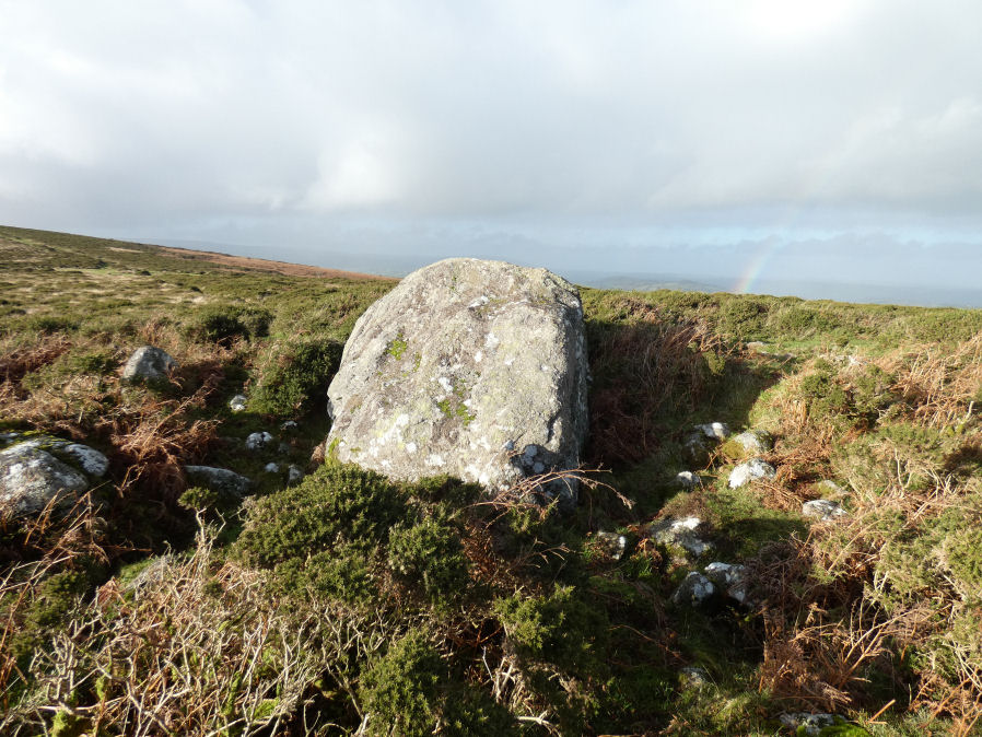
Photo taken on 10-12-2025
Database entries
OS Map: SX 73358 82318
OS Source: Garmin
Butler OS: SX73358231
HER: MDV8767
Megalithic Portal: 45848
PMD: Easdon Tor
Alternate name: Easdon Hill
Short Name: RC Easdon Hill
Butler map: 22.3
Grinsell: MANATON 1
Turner: A61
Exist: Yes
Record: Unique
Record Source: Butler
Hut Class: No
Cairn Class: Yes
Dimensions (m): 15.5
Lidar: SX 73358 82318
Guide Map: 30
Nearest Bus Stop (Minor): Manaton Bus Shelter (2.6 km) [Route: 271,671]
Nearest Bus Stop (Major): Moretonhampstead Court Street Car Park (4.2 km) [Route: 173, 171(20/07/26 to 19/09/26)]
Nearby sites: SX 73358 82318
Notes
HER: A cairn with a large centrally placed rock which is possibly the capstone of a kist. Robbers have excavated around and about this giving a rock strewn central hollow to the cairn. There is no encircling ditch. The capstone is approximately square. Touching its base at the east is a triangular shaped orthostat. The cairn is situated on the very summit of a hill.. HER referring to Turner: Turner identifies this site as a ring cairn. Internal diameter 6 metres, with bank 2.5 metres wide and 1 metre high ... Encircles a natural boulder, 2.8 metres wide, 1.6 metres thick and up to 2.5 metres high. Reave on north-western side.The author visited this site with Steve Szypko on 10/12/2025. It has the appearance of a tor cairn. The central stone is massive and on the summit of the slope the cairn has clearly been built around it. While it is conceivable that the central stone could have been used as the location of a cist type burial it is very clearly not a cist.
References
These are selected references with an emphasis on out of copyright sources linked as PDFs. For more detailed references try any linked HER or PMD record above.
- Butler, Jeremy, Dartmoor Atlas of Antiquities, vol.1: The East, (1991)
- Grinsell, L.V., Dartmoor Barrows, Devon Archaeological Society Proceedings No.36 (1978)
- Turner, J.R., Ring Cairns, stone circles and related monuments on Dartmoor, D.A.S.P. No.48 pp.27-86 (1990)
- Wall, J. Charles, Ancient Earthworks, The Victoria History of the County of Devon: v. 1 pp.573-630 (1906)