
Guide to the Monuments on Cosdon Hill
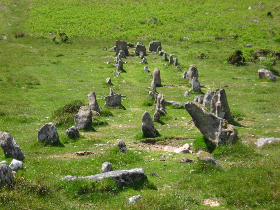
Table of Ritual and Burial Monuments on Cosdon Hill
The following table lists the records currently in this Guide Map. For an explantion of the Guide Maps and a table of all 62 Guide Maps, follow this link: Guide List Table. Introductory text will be added to each guide list in 2025. Notes on duplication and omissions will appear below the table once checks have been finalised.
Notes on possible duplications and omissions
Eight Rocks and Butler Map 40 Site 8: There are duplicate HER entries relating to site 8 on Butler map 40 Vol.2.1) HER record MDV103625 (SiteID=2632) is duplicated by MDV13050 (SiteID=1299) and both refer to cairn 1 (Cosdon Hill N.1 40.8.1)
2) Butler entry N.3. 40.8.3 is a cist, two standing stones separated by two large parallel flat stones. Butler believes these may be the remains of a well-known stone setting called the Eight Rocks which existed on the hillside here until sometime in the 19th century. "This was probably the retaining circle of a cairn like the Nine Stones or Nine Maidens on Belstone Common". The HER entry MDV6918 (SiteID=1301) relates to the current arrangement which is easy to find. The HER entry MDV7395 (SiteID=500) relates to Eight Rocks which may or may not match N3 - given it could be a different site it is reasonable to keep it as a valid separate record although the location is then unknown. The HER entry MDV6915 (SiteID=499) must be a duplicate of one or the other of these two records.
Ward Lock's Guide to Dartmoor Both of these HER entries already state that they are duplicates relating to Ward Lock's map entries.
1) There are two entries on the HER that seem to relate to this feature Cosdon Hill 3. These are MDV6898 (SiteID=420) and MDV6914 (SiteID=3042). The latter entry on the HER states: "appear to be duplicate features. See also MDV6922."
2) There are two entries that relate to the cists at the end of the Cosdon Stone Row. MDV48906 (SiteID=395) and MDV6922 (SiteID=3043) "Two ruined cists on Cosdon noted in Ward Lock Guide to Dartmoor. Neither known to Worth (1950) and features not found; appear to be duplicate features. See also MDV6914".
Possible sites for addition to HER?
Neither of these are strong candidates for addition, but for completeness they are mentioned:
1) Cosdon Hill E. Reported Cairn (SiteID=1293). This is SOUTH TAWTON 5b, Butler 40.6. It originates with this "Nothing was found in a second cairn excavated by the Committee 'on the side of Cosdon', an unhelpfully loose description considering the size of the hill, and this cairn has yet to be relocated". on p. 181 of the Third DEC report. The grid reference is from Grinsell and is presumably guess work from the very limited information. It might not be worth adding to the HER. I could not find any reference to it within 500m.
2). Cosdon Hill 6 Cist (SiteID=463). This is thought to be a cist reported by Falcon. It is mentioned in the HER entry for a nearby cist (Cosdon Beacon Cairn Circle and Cist (SiteID=419), MDV6925). Does it warrant a separate entry? In my view it is a separate feature.
3). There are more entries here which do not have HER entries. In the view of the author they are not suitable records for the HER but are suitable for this website.
PS. These notes are to assist untangling complicated records and are neither permanent nor a criticism of the HER who do a fantastic job! The author finds it easier to systematically work through these records (2000+ of them) and add these notes, which are then to be communicated with the HER, if appropriate, it is a pragmatic way of dealing with lots of data without continually stopping and starting.
Cosdon Hill Guide Map
Guidance for walkers: The monuments featured in this database are archaeological treasures and need to be protected and preserved - please do not disturb any sites. Please check access and firing times before visiting sites, not all sites listed are on open access land. Firing ranges and boundaries of open access areas are marked on the OL28 OS Dartmoor Explorer map. Please stick to the country code and consider giving support to the numerous agencies that help to keep Dartmoor a fabulous natural and historic environment!
List of Ritual and Burial Monuments on Cosdon Hill
Cosdon Beacon Cairn
OS Map: SX 63611 91502
HER record: MDV6885
Megalithic Portal: 10325
Alternate name: Cosdon Beacon 1 Cairn
ShortName: CN Cosdon 1
Butler map: 40.7.1
DPD page: 153
Grinsell: ST 3
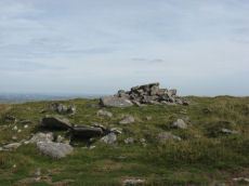
Notes: Cairn 27m diameter, height 1.8m, crowned by modern stone heap and OS trig pillar. Large hollows in the top, from robbing, would have protected beacon fires. Butler Cosdon Beacon 1 Vol. 2. Map 40.7.1. (diagram of Cosdon Summit cairns on p.207). See also MDV6883.
Nearby sites: SX63619150
Cosdon Beacon East Stone Ring Cairn Circle
OS Map: SX 63663 91492
HER record: MDV6928
Megalithic Portal: 10325
Alternate name: Cosdon Beacon 2 Stone Ring Cairn Circle
ShortName: RC Cosdon 2
Butler map: 40.7.2
DPD page: 152
Grinsell: ST 4
Turner: A6
Notes: Located 25m to east of Cosdon Beacon. A near circular bank 1.6m wide of double slab construction and about 21m across. Turner A6 (diagram p.59). NMR Cairn A. Butler Cosdon Beacon 2 Vol. 2. Map 40.7.2. (diagram of Cosdon Summit cairns on p.207).
Nearby sites: SX63669149
Cosdon Beacon Embanked Cairn Circle and Cist
OS Map: SX 63708 91593
HER record: MDV6898
Megalithic Portal: 10325
PMD: Cosdon Summit S.
Alternate name: Cosdon Hill 3 Embanked Cairn Circle and Cist
ShortName: CT Cosdon 3
Butler map: 40.7.3
Butler Vol 5: p.164 & Fig.105
DPD page: 152
Grinsell: ST 2
Turner: B14
Barrow Report: 21
Notes: "Ring cairn and cist on summit ridge of Cawsand Hill. Cairn forms part of a cemetery including at least 2 round cairns, 2 ring cairns and one platform cairn. Earthwork survives as a 2m wide and 0.4m high circular rubble bank, faced with close set stones around its outer edge and surrounds an internal area measuring 18m ew by 17m ns. A mound measuring 6m in diam and 0.2m high stands in the centre of the area enclosed by the circular bank and contains a stone cist with 2 slabs surviving." Turner B14(diagram p.59). Butler Cosdon Beacon 3 Vol. 2. Map 40.7.3 (diagram Vol. 5. p.164). NMR Cairn B. Possible cist? This site is difficult to photograph, the photo shows part of one side of the ring.
Nearby sites: SX63719159
Cosdon Hill 3 (duplicate) Reported Cist
OS Map: SX 63580 91040
HER record: MDV6914
PMD: Cosdon S 1
ShortName: CT:Cosdon 3dup
Notes: Radcliffe states that the dilapidated kistvaen 8ft square on cosdon summit is the same site as sx69sw/24 at ngr sx63719160 HER 6898.
Confirmed duplicate - no action required on HER. Removing from PDW Guide listing.
Nearby sites: SX63589104
Cosdon Beacon Cairn Circle & Cist
OS Map: SX 63721 91660
HER record: MDV6925
Megalithic Portal: 10325
Alternate name: Cosdon Hill 4 Cairn Circle & Cist
ShortName: CN Cosdon 4
Butler map: 40.7.4
Butler Vol 5: p.183 & Fig.125
DPD page: 153
Grinsell: ST 1b
Notes: "Cairn mound measures 7m in diam and stands up to 0.6m high. A central hollow, 2m by 1.8m by 1m deep, is faced on two sides with large slabs which may represent the cist described by falcon in 1905 as being 4ft long by 2ft wide. A ring of edge set stones around this cist is visible and may represent an internal kerb, which survives largely as a buried feature".
Nearby sites: SX63729166
Cosdon Beacon Platform Cairn Circle
OS Map: SX 63717 91719
HER record: MDV6924
Megalithic Portal: 10325
Alternate name: Cosdon Beacon 5 Platform Cairn Circle
ShortName: PC Cosdon 5
Butler map: 40.7.5
DPD page: 153
Grinsell: ST 1
Turner: E1
Notes: Cairn 13.5m diameter with signs of retaining circle. Crowned by modern stone heap. HER MDV6894. See also: NMR 444167. Lethbridge diagram p.152, photo bottom right p.153. Turner E1 (diagram p.59). Butler Cosdon Beacon 5 Vol. 2. Map 40.7.5. (diagram of Cosdon Summit cairns on p.207).
Nearby sites: SX63729172
Cosdon Beacon Cist
OS Map: SX 63740 91653
HER: No record found
PMD: Cosdon Summit N.
Alternate name: Cosdon Hill 6 Cist
ShortName: CT Cosdon 6
Notes: The cist was originally noted by Falcon as being approximately 3 1/2ft to 4ft long and 2ft wide, aligned apparently NE-SW. The SW and NE sides were fairly recognizable. This cist is very near to the Cosdon Hill 4 cairn (Cosdon Beacon Cairn Circle and Cist (SiteID=419), MDV6925) and the details of this site have been incorporated and sometimes confused by numerous authors. Butler perhaps gives a fleeting mention as "Two slabs on the edge of the pit are probably the sides of a cist." although it is not clear whether this is a reference to part of Cosdon Hill 4. Neither the NMR nor the HER have separate entries for this feature but it is mentioned as part of the covreage of Cosdon Hill 4 "Two stones set on edge on the eastern periphery of the mound may represent a second cist."
Nearby sites: SX63749165
Cosdon Beacon Reported Cairn
OS Map: SX 63716 91666
HER: No record found
Alternate name: Cosdon Hill 7 Reported Cairn
ShortName: CN Cosdon 7
DPD page: 153
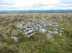
Notes: An arrangement a few paces north of cosdon Hill 4 and of a very similiar appearance. Might be a modern arrangement, perhaps the work of stone cutters? There is a notable cist shaped hole within this feature. Lethbridge diagram p.152, photo bottom right p.153. This feature appears not to be mentioned anywhere else.
Nearby sites: SX63729167
Cawsand Hill Cairn
OS Map: SX 63736 91668
HER record: MDV13063
ShortName: CN CawsandHill
Grinsell: ST 1a
Nearby sites: SX63749167
Cosdon Hill N.1 Cairn
OS Map: SX 63600 93300
HER record: MDV13050
ShortName: CN:Cosdon N1
Butler map: 40.8.1
Notes: NGR could be SX 63504 93207 which is 100m to the SW. Butler states "At the north end of the hill an inconspicuous turf-covered cairn with shallow central depression lies on the hillside just above the enclosed land". The author looked for this cairn on 12/09/21 but was unable to find it within the deep vegetation cover.
13/12/2024: The record is duplicated on the HER by MDV103625. Butler gave a grid reference of SX 6360 9330 (previously used here). Record MDV103625 has SX 63504 93207 which is 100 metres to the SW.
Nearby sites: SX63609330
Cosdon Hill N.1 (duplicate) Reported Cairn
OS Map: SX 63504 93207
HER record: MDV103625
ShortName: CN:CosdonN1dup
Nearby sites: SX63509321
Cosdon Hill N.2 Cairn
OS Map: SX 63540 93160
HER record: MDV6916
PMD: Skaigh Warren
ShortName: CN Cosdon N2
Butler map: 40.8.2
Grinsell: ST 8
Notes: Remains of a probable cairn/cist located approximately 350 metres south-east of Skaigh Warren, consisting of a scatter of stones, surrounding one set slab.
Nearby sites: SX63549316
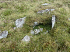
Cosdon Hill N.3 Cist
OS Map: SX 63604 93067
HER record: MDV6918
PMD: Skaigh
ShortName: CT Cosdon N3
Butler map: 40.8.3
Grinsell: ST 9
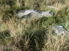
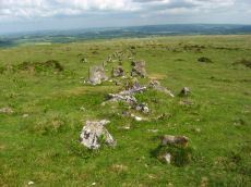
Notes: The remains of the cist, almost certainly that noted by Crawford, consist of two end stones 0.8 metres high and 0.5 metres wide, 1.8 metres apart and oriented north-west/ south-east. Between these uprights lie two fallen granite side-slabs, 1.5 metres long and 0.5 metres wide. "Butler believes these may be the remains of a well-known stone setting called the Eight Rocks which existed on the hillside here until sometime in the 19th century. This was probably the remaining circle of a cairn like the Nine Stones or Nine Maidens on Belstone Common (PRN6865), reputed to come alive and dance (Crossing, 1912)."
See the entry for Eight Rocks for further discussion.
Nearby sites: SX63609307
Cosdon Hill N.3 (duplicate) Cairn Circle
OS Map: SX 63600 93200
HER record: MDV6915
ShortName: CN:CosdonN3dup
Notes: "Site of a possible stone circle (or cairn circle) destroyed sometime around 1874. Site said to exist above Sticklepath, below Cawsand (Cosdon)." Could this be a duplicate of Eight Rocks (SiteID=500). Butler (p.207 of Vol 2) suggests that Cosdon Hill N.3 (HER MDV6918) is the most likely candidate for the remains of Eight Rocks (as a former cairn circle).
13/12/24: This entry was formerly listed here as Skaigh Warren Cairn Circle, now changed to Cosdon Hill N.3 (duplicate) - now marked as a duplicate. It is either a duplicate of the entry for N3 or for Eight Stones.
Nearby sites: SX63609320
Eight Rocks (site of) Reported Stone Circle
OS Map: SX 64500 92500
HER record: MDV7395
ShortName: SCxEight Rocks
Notes: "Site of a stone circle, since destroyed, originally thought to have been located somewhere between Cosdon Hill and Ford Farm, South Tawton. Nothing remains today; the circle was apparently robbed out in the later 19th century by men from Ramsley Copper Mine, South Zeal."
Nearby sites: SX64509250
Sticklepath Reported Stone Circle
OS Map: SX 63430 92640
HER record: MDV7395
Megalithic Portal: 22693
ShortName: SC:Sticklepath
Notes: This feature was reported by The Captain on the Megalithic Portal on 20/06/2004 and a site page was made (linked to this record). The author there states: "I would estimate the circle to be between 30 and 35 metres diameter, with a possible 18 evenly spaced stones remaining, all either as stumps or flat to the ground."
Nearby sites: SX63439264
Cosdon Hill Encircled Cairn
OS Map: SX 63350 92479
HER record: MDV13064
Megalithic Portal: 22695
Alternate name: Cosdon Hill N.4 Encircled Cairn
ShortName: EC Cosdon N4
Butler map: 40.9
Grinsell: ST 10
Notes: Cairn at the junction of two Bronze Age reaves. "Round cairn on Cosdon Hill, measuring 7.3 metres in diameter and standing up to 0.8 metres high. A number of edge set stones visible around the southern side of the cairn mound suggests the existence of a kerb. There is a hollow in the north side of the mound, probably the result of partial robbing or an early excavation."
Nearby sites: SX63359248
Cosdon Hill N.W.1 (c.8+) Cairnfield Master
OS Map: SX 62900 92700
HER record: MDV14436
ShortName: CN:CosdonNWCFM
Butler map: 40.10
Notes: Cairnfield on Cosdon Hill, consisting of at least eight cairns.
Nearby sites: SX62909270
Cosdon Hill N.W.2 Cist
OS Map: SX 63040 92659
HER record: MDV63639
ShortName: CT:Cosdon NW2
Butler map: 40.10
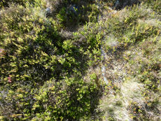
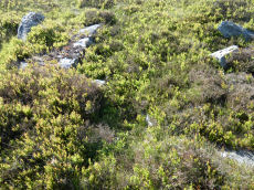
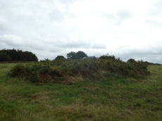
Notes: Cairn measures 9.5 metres in diameter, height 1 metre. Cist 3 metres by 3 meters by 0.1 metre deep. Grass, heather and gorse covered mound with stones protruding through the turf on the northern side of the mound. The author was unable to locate this site within the dense vegetation cover on 13/09/21.
Nearby sites: SX63049266
Cosdon Hill N.W.3 Crop Mark
OS Map: SX 62950 92200
HER record: MDV27928
ShortName: CNxCosdon NW3
Notes: Aerial Photograph
Nearby sites: SX62959220
Cosdon Hill N.W.4 Crop Mark
OS Map: SX 63020 92180
HER record: MDV27931
ShortName: CNxCosdon NW4
Notes: Aerial Photograph
Nearby sites: SX63029218
Skaigh Warren Cairnfield Master
OS Map: SX 63100 93500
HER record: MDV64170
ShortName: CN:SkaighWa M
Notes: HER: A group of clearance cairns lying on a north-facing slope overlooking Belstone Cleave interspersed with Bronze Age hut circles and Medieval or later pillow mounds.
Nearby sites: SX63109350
Skaigh Warren 1 Reported Cairn
OS Map: SX 63300 93600
HER record: MDV13052
ShortName: CN?SkaighWa 1
Notes: "Many small cairns situated on the natural terrace here. Possible prehistoric cairn group."
Nearby sites: SX63309360
Skaigh Warren 2 Reported Cairn
OS Map: SX 63700 93600
HER record: MDV13053
ShortName: CN?SkaighWa 2
Notes: "Many small cairns within modern enclosure here. Possibly the result of field clearance but quite likely to be a group of prehistoric cairns."
Nearby sites: SX63709360
Cosdon Hill East Cairnfield Master
OS Map: SX 64890 91820
HER record: MDV59589
ShortName: CN:CosdonE M
Nearby sites: SX64899182
Cosdon Hill East 1 Cairn
OS Map: SX 64880 91810
HER record: MDV59590
ShortName: CN:CosdonE 1
Nearby sites: SX64889181
Cosdon Hill East 2 Cairn
OS Map: SX 64890 91830
HER record: MDV59591
ShortName: CN:CosdonE 2
Nearby sites: SX64899183
Cosdon Hill East 3 Cairn
OS Map: SX 64900 91840
HER record: MDV59592
ShortName: CN:CosdonE 3
Nearby sites: SX64909184
Cosdon Hill East 4 Cairn
OS Map: SX 64910 91860
HER record: MDV59593
ShortName: CN:CosdonE 4
Nearby sites: SX64919186
Cosdon Hill East 5 Cairn
OS Map: SX 64910 91840
HER record: MDV59594
ShortName: CN:CosdonE 5
Nearby sites: SX64919184
Cosdon Hill East 6 Cairn
OS Map: SX 64910 91810
HER record: MDV59595
ShortName: CN:CosdonE 6
Nearby sites: SX64919181
Cosdon Hill East 7 Cairn
OS Map: SX 64910 91820
HER record: MDV59596
ShortName: CN:CosdonE 7
Nearby sites: SX64919182
Cosdon Hill East 8 Cairn
OS Map: SX 64930 91790
HER record: MDV59597
ShortName: CN:CosdonE 8
Nearby sites: SX64939179
Cosdon Hill East 9 Cairn
OS Map: SX 64930 91830
HER record: MDV59598
ShortName: CN:CosdonE 9
Nearby sites: SX64939183
Cosdon Hill E. Reported Cairn
OS Map: SX 64300 91500
HER: No record found
ShortName: CN?Cosdon E
Butler map: 40.6
Grinsell: ST 5b
Notes: Butler: "Nothing was found in a second cairn excavated by the Committee 'on the side of Cosdon', an unhelpfully loose description considering the size of the hill, and this cairn has yet to be relocated". See p.181 Third report of DEC.
Nearby sites: SX64309150
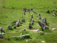
Cosdon Stone Row
OS Map: SX 64317 91600
HER record: MDV6886
Megalithic Portal: 1858
The Stone Rows of GB: Cosdon
PMD: Cosdon Stone Row
ShortName: SR Cosdon
Butler map: 40.6
DPD page: 152
Notes: "A triple stone row lies near the summit of Cosdon Hill and is 447 feet in length measured from the centre of the circled cairn which stands at the west end. At 225 feet from the west end there is a slight change in direction and the rows turn somewhat northward. This change of direction may be said to divide the row into western and an eastern section. Overall width, western part is 8 feet 10 inches, eastern part 10 feet 8 inches. The cairn is 26 feet in diameter and contains the remains of two cists; the retaining circle is very irregular. There is no formal feature to mark the termination of the rows at their eastern end"
Nearby sites: SX64329160
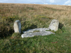
Cosdon (stone row) Platform Cairn Circle and Cist
OS Map: SX 64331 91597
HER record: MDV48906
Megalithic Portal: 813
PMD: Cosdon Stone Row
Alternate name: Cosdon Hill Stone Row Platform Cairn Circle and Cist
ShortName: CT Cosdon Row
Butler map: 40.6
Butler Vol 5: p.234 & Fig.165
DPD page: 152
Grinsell: ST 5
Turner: E15
Notes: "The cairn associated with the Cosdon Hill triple stone row is 26 feet in diameter and contains the remains of two cists; the retaining circle is very irregular. Of the two cists, one is intact, the other has been robbed of the cover-stone and two side-stones." Lethbridge diagram p.152, cists pictured. Butler Cosdon Hill Stone Row - Vol. 2. Map 40.6 (diagram p.205).
Nearby sites: SX64339160
Cosdon Hill Stone Row (duplicate) Reported Cist
OS Map: SX 64330 91600
HER record: MDV6922
PMD: Cosdon S 2
ShortName: CT:Cosdon SR
Notes: Second of two ruined cists on Cosdon Hill. Ward Lock refers to "a triple row with remains of two kistvaens" lower down from Cosdon summit, so presumably this is the same as SMR SX 69 SW/19? THE HER grid reference for this is almost 1km out. The grid reference given is SX 63630 91370 which is centered on Cosdon Hill as a geographical entity. THis entry clearly relates to the cairn and cist at the end of the stone row so we will give it a grid reference of SX 64330 91600.
Confirmed duplicate - no action required on HER. Removing from PDW Guide listing.
Nearby sites: SX64339160
Blackaton Brook Reported Stone Row
OS Map: SX 64800 90800
HER: No record found
ShortName: SR:Blackaton
Notes: Breton p.53 To the N. of it [Breton is referring to the Cosdon Triple row] are clitters of rocks, a short distance to the S, a swamp in which a feeder of the Blackaton Brook rises. On its E. slopes are the remains of a stone row. The feeder referred to is the Cheriton Comb which passes a boggy area. This would place the row at approximately SX 648 908. There is no known stone row at this point and this author is unaware of other accounts. This section of the Blackaton Brook has been greatly disturbed by stream workings.
Nearby sites: SX64809080
Shilley Pool N. Cairn Circle
OS Map: SX 65030 91420
HER record: MDV6945
PMD: Shilley Pool N.
ShortName: CN:ShilleyPool
Butler map: 39.6
Grinsell: ST 5a
Notes: Mound, possibly a barrow, shown on os 6" as 'mound', on 1:25000 os as 'tumulus'.
Nearby sites: SX65039142
Shilley Pool W Cairnfield Master
OS Map: SX 64800 91300
HER record: MDV60365
ShortName: CN:ShilleyPl W
Notes: HER: Bronze Age cairnfield consisting of at least 25 cairns between 0.4 metres and 0.8 metres high. Of these 14 are circular with diameters of between 3 metres and 6.9 metres. The remainder are ovoid and vary form 4 metres and 10.2 metres long. One cairn has a kerb of edge set stones this is probably a funerary round cairn. It is surrounded by a 1.5 metre wide 0.3 metre high platform. It has been damaged by robbing or early excavation.
Nearby sites: SX64809130
Ramsley Stone Row
OS Map: SX 65100 93100
HER record: MDV6950
PMD: Ramsley Stone Row
ShortName: SRxRamsley
Notes: "There is evidence for the former existence of stone rows at Ramsley above South Zeal. They were destroyed some 25 years ago by works in connection with the Ramsley Mine and only a few of the smaller and less important stones remain. Mr George French, working at Ramsley at the time, recollects their existence." Destroyed site, might have been field wall. Grid reference given is that of the vicinity of the Ramsley cairn.
Nearby sites: SX65109310
Ramsley Hill (site of) Reported Cairn
OS Map: SX 65186 93032
HER: No record found
ShortName: CN-Ramsley
Butler map: 41.
Notes: Butler lists this amongst the cairns for his Map 41. However Map 40 was probably intended where there is a discussion of streamworking and associated mounds. Also there was a ninteenth century report of a stone row and associated monuments at Ramsley that no longer exist.
Nearby sites: SX65199303
West Wyke 1 Reported Cairn
OS Map: SX 65780 92770
HER record: MDV13067
ShortName: CN?WestWyke 1
Nearby sites: SX65789277
West Wyke 2 Reported Cairn
OS Map: SX 65720 92800
HER record: MDV13068
ShortName: CN?WestWyke 2
Nearby sites: SX65729280
West Wyke 3 Reported Cairn
OS Map: SX 65680 92800
HER record: MDV13069
ShortName: CN?WestWyke 3
Notes: Flat topped massive cairn, possibly built round natural outcrop, more or less on highest point of rough pasture field. It lies immediately to the e of relict boundary which runs approx. N-s.1:2500 os maps shows triangulation point here, but no sign of this could be seen.
Nearby sites: SX65689280
Oxenham Arms Standing Stone
OS Map: SX 65014 93606
HER record: MDV13065
Megalithic Portal: 8401
PMD: Oxenham Arms
ShortName: SS OxenhamArms
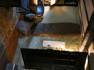
Notes: "The Oxenham Arms, now an inn, is the former manor house and home of the Burgoyne family. A courtyard plan house, it was originally a two-room-and-through passage plan. An interesting feature is an enormous upright slab of granite built into the inner wall of the rear parlour. This looks very much like a prehistoric standing stone and it seems that the house was built around it".
Nearby sites: SX65019361
A30 Embankment 1 Reported Cist
OS Map: SX 62900 95000
HER record: MDV41469
PMD: A30 Embankment
ShortName: CT?A30Embank 1
Notes: Destroyed? Possibly cist seen (shepherd).
Nearby sites: SX62909500
Page last updated 10/12/24