
Guide to the Monuments on Gidleigh Common and Scorhill
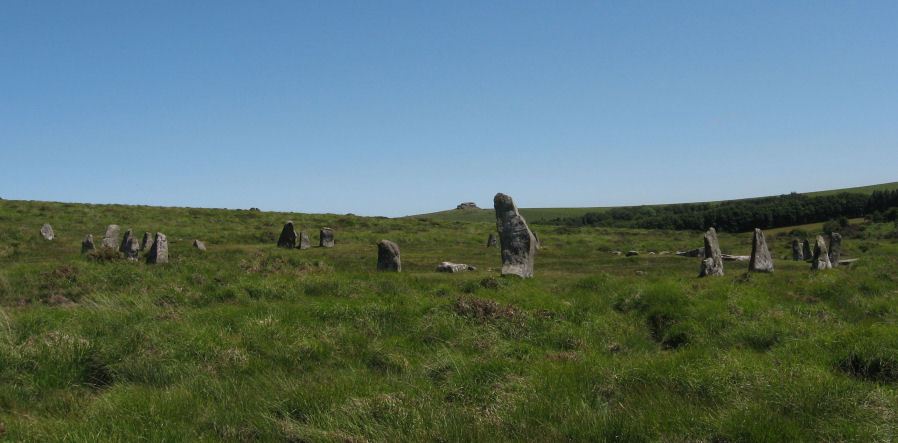
Table of Ritual and Burial Monuments on Gidleigh Common and Scorhill
The following table lists the records currently in this Guide Map. For an explantion of the Guide Maps and a table of all 62 Guide Maps, follow this link: Guide List Table. Introductory text will be added to each guide list in 2025. Notes on duplication and omissions will appear below the table once checks have been finalised.
Notes on possible duplications and omissions
Butler South Cairns Duplicates: The entries in Volume 2 appear to be confused and duplicated for the South and North cairns. Possibly Butler intended two sets of records for one or both but the grid references are duplicated. In Vol 5 Butler covers features omitted or requiring updates from the earlier volumes. The starting point to understand the South cairns is Fig. 175 (p.249 Vol 5) which is the master source for our entries. The South entries from Volume Two are arbitrarily assigned to the master record as impossible otherwise to untangle and processing this way allows us to have a unique record for each Volume Two entry.Butler North Cairns Duplicates:. It seems likely these records are simply duplicated leading to four entries for two cairns. Fieldwork is required to confirm this. NB. There are remarkably few mistakes in Butlers listings but it is not surprising that the occasional one slipped through!
Rival Tor Reported Cairn: This record originated on the old NMR listings and seems likely a duplicate of Kennon Hill S.1 Reported Cist (MDV61776). No HER entry but not required if it is a duplicate. Fieldwork required to confirm.
HER Omissions The Butler cairns S.3, S.4, S.5 (see Vol 5) are not included on the HER, there could be a case for their addition. These features are not confirmed by fieldwork.
PS. These notes are to assist untangling complicated records and are neither permanent nor a criticism of the HER who do a fantastic job! The author finds it easier to systematically work through these records (2000+ of them) and add these notes, which are then to be communicated with the HER, if appropriate, it is a pragmatic way of dealing with lots of data without continually stopping and starting.
Gidleigh Common and Scorhill Guide Map
Guidance for walkers: The monuments featured in this database are archaeological treasures and need to be protected and preserved - please do not disturb any sites. Please check access and firing times before visiting sites, not all sites listed are on open access land. Firing ranges and boundaries of open access areas are marked on the OL28 OS Dartmoor Explorer map. Please stick to the country code and consider giving support to the numerous agencies that help to keep Dartmoor a fabulous natural and historic environment!
List of Ritual and Burial Monuments on Gidleigh Common and Scorhill
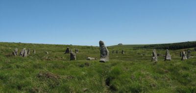
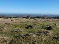
Scorhill Stone Circle
OS Map: SX 65458 87399
HER record: MDV6122
Megalithic Portal: 540
PMD: Scorhill Stone Circle
ShortName: SC Scorhill
Butler map: 38.8
Butler Vol 5: p.249 & Fig.175
DPD page: 146
Turner: G6
Notes: One of the most impressive stone circles on Dartmoor and one of the few that has not been restored. The circle consists of 23 granite slabs up to 2.5m high with a further 11 recumbent stones. The circle is not the largest in terms of diameter but it is the most striking circle on Dartmoor with some of the largest standing stones. See also, Legendary Dartmoor: Scorhill Stone Circle and HER MDV6122
Nearby sites: SX65468740
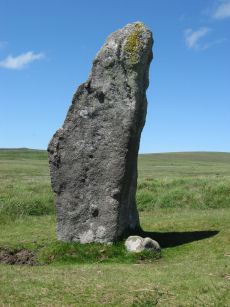
Scorhill Circle Standing Stone
OS Map: SX 65460 87380
HER record: MDV6122
Megalithic Portal: 540
PMD: Scorhill Stone Circle
ShortName: SS Scorhill
Butler map: 38.8
DPD page: 146
Notes: Largest stone in the Scorhill Circle. In strict terms this would not typically be classified as a "standing stone" as it is a member of the stone circle. It is the largest stone in a Dartmoor stone circle at 8 feet 2 inches tall.
Nearby sites: SX65468738

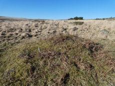
Scorhill Reported Stone Row
OS Map: SX 65485 87207
HER record: MDV130497
Megalithic Portal: 25238
PMD: Scorhill Stone Row
ShortName: SR Scorhill
Butler map: 38.8
Butler Vol 5: p.172 & Fig.112
DPD page: 146
Notes: N. Teign. Claimed by Butler.See also Butler Vol 5 p. 249 fig. 175. Possible stone row near long cairn south-east of the Scorhill stone circle recorded by Butler (1991), although Gerrard was not convinced during Monument Protection Programme visit in 1998 and was not included in scheduling. Site visit in 2021 recorded potential row.. Visited by author on 06/02/2025 and the feature can be seen but currently looks like stones that may have been disturbed, tumbled, from the cairn that happen to form a short linear features. Changed entry from stone row to reported stone row as I'm inclined to agree with Gerrard.
Nearby sites: SX65498721

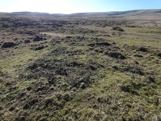
Scorhill S.1 Platform Cairn Circle
OS Map: SX 65534 87272
HER record: MDV130493
Megalithic Portal: 25238
ShortName: PC Scorhill S1
Butler map: 38.8.1
Butler Vol 5: p.249 & Fig.175
Turner: E25
Notes: "A platform circle; ring of kerb stones 4.5m internal diam, enclosing flat-topped cairn 0.45m high. Indication of a stone ring/ring cairn beneath cairn (turner)." Entry added by PDW to correct/replace Butler 38.4.1. This is cairn 1 in Fig. 175 (p.249 Vol 5). Formerly listed as PC:Scor Leat
Nearby sites: SX65538727
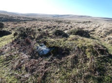
Scorhill S.2 Cairn
OS Map: SX 65485 87212
HER record: MDV6196
PMD: Scorhill S.
ShortName: CN Scorhill S2
Butler map: 38.8.2
Butler Vol 5: p.172 & Fig.112
Grinsell: GID 2a
Notes: Entry added by PDW to correct/replace Butler 38.4.2. This is cairn 2 in Fig. 175 (p.249 Vol 5), it is the cairn that heads the claimed stone row on Fig 112.
Formerly CN:Scorhill 8
Nearby sites: SX65498721
Scorhill S.3 Reported Cairn
OS Map: SX 65494 87221
HER: No record found
ShortName: CN Scorhill S3
Butler map: 38.8.3
Butler Vol 5: p.172 & Fig.112
Notes: Entry added by PDW. This is cairn 3 in Fig. 175 (p.249 Vol 5).
Nearby sites: SX65498722
Scorhill S.4 Reported Cairn
OS Map: SX 65520 87196
HER: No record found
ShortName: CN Scorhill S4
Butler map: 38.4.1
Butler Vol 5: p.249 & Fig.175
Notes: Butler entry, coords given are for 38.8.1. Previously listed here as Scorhill S.1 (duplicate) CNxScorhill 7. In volume Two on p.243 are listed entries 4.1 and 4.2 as S.1 and S.2 which appears to duplicate other entries. The diagram in Fig. 175 in Volume 5 has 5 Scorhill South cairns. This entry and 4.2 have been resinstated as non-duplicates and arbitrarily assigned to S4 and S5.
Nearby sites: SX65528720
Scorhill S.5 Reported Cairn
OS Map: SX 65519 87191
HER: No record found
ShortName: CN Scorhill S5
Butler map: 38.4.2
Butler Vol 5: p.172 & Fig.112
Notes: Butler entry, coords given are for 38.8.2. Previously listed here as Scorhill S.2 (duplicate), CNxScorhill 9. In volume Two on p.243 are listed entries 4.1 and 4.2 as S.1 and S.2 which appears to duplicate other entries. The diagram in Fig. 175 in Volume 5 has 5 Scorhill South cairns. This entry and 4.1 have been resinstated as non-duplicates and arbitrarily assigned to S4 and S5.
That leaves S3 missing next to S2 and a new record will be created to cover that one. The grid reference for S5 from Butler Vol 5 diagram approximates to SX 65519 87191.
Nearby sites: SX65528719
Scorhill N.1 Cairn
OS Map: SX 65740 87734
HER record: MDV6201
ShortName: CN Scorhill N1
Butler map: 38.10.1
Butler Vol 5: p.186 & Fig.129
Grinsell: GID 4
Notes: Entry added by PDW to correct/replace Butler 38.10.1 One of a pair of cairns on the eastern edge of Gidleigh Common. Scheduled. Round cairn with two kerbs, 7.5 metres and 9.5 metres in diameter. Central disturbance. See also Butler Vol 5 p. 249 fig. 175
Nearby sites: SX65748773
Scorhill N.2 Cairn
OS Map: SX 65755 87754
HER record: MDV6211
PMD: Creaber
ShortName: CN Scorhill N2
Butler map: 38.10.2
Butler Vol 5: p.249 & Fig.175
Grinsell: GID 5
Notes: Entry added by PDW to correct/replace Butler 38.10.2 Two cairns; probably the two objects (kists?) shown by Crawford (1950). Round cairn diameter 12 metres, height 0.6 metres. A robbing pit south of centre is 2.5 metres long, 1.8 metres wide by 0.3 metres deep and is orientated at 120 degrees.
Nearby sites: SX65768775
Scorhill N.3 Reported Cairn
OS Map: SX 65380 87750
HER record: MDV132802
ShortName: CN:Scorhill N3
Notes: HER: Turner recorded a possible cairn here in 1978 but a subsequent Ordnance Survey visit cast doubt on the identification / location; appears a mis-identification of the hut circle MDV132781 to the north.
Nearby sites: SX65388775
Scorhill N.1 (duplicate) Reported Cairn
OS Map: SX 65730 87700
HER record: MDV6201
ShortName: CNxScorN1_Dup
Butler map: 38.6.1
Notes: Incorrect Butler entry, coords given are for 38.10.1. Possibly thisshoud have been cairn in settlement to the north.
Nearby sites: SX65738770
Scorhill N.2 (duplicate) Reported Cairn
OS Map: SX 65740 87740
HER record: MDV6211
ShortName: CNxScorN2_Dup
Butler map: 38.6.2
Notes: Incorrect Butler entry, coords given are for 38.10.2. Possibly this should have been cairn in settlement to the north.
Nearby sites: SX65748774
Scorhill N Reported Stone Row
OS Map: SX 65740 87820
HER record: MDV6189
Megalithic Portal: 25238
ShortName: SR:ScorhillN
Notes: HER: (1950) Stone row. SX 65628794 to SX 65748782. (09/07/1974) There is no alignment of stones in this area of moorland which can be considered other than natural. It is doubtful if the alleged stone row was ever seen by Crawford. The information most probably came from H H Breton, an unreliable correspondent of c 1925.
Nearby sites: SX65748782
Gidleigh Reported Cairn
OS Map: SX 65540 87580
HER record: MDV6188
ShortName: CC:Gidleigh
Notes: HER: Possible stone circle on Gidleigh Common, first recorded in 1925. Doubtful feature not positively identified since 1925.
(Area centred SX 65548758) Stone Circle, 6 metres in diameter. Ten stones remain, three still standing. (H H Breton undated but thought to be around 1925)
Doubtful; probably a retaining circle. (R H Worth, 1948). This is probably a reference to The Heart of Dartmoor.
This might be the round house approx. 100 metres to the south at SX 6566 8742.Scorhill Down Round House
Nearby sites: SX65548758
Buttern Hill (site of) Reported Cist
OS Map: SX 65220 88070
HER record: MDV6190
PMD: Buttern Hill S.
ShortName: CNxButtern H4
Notes: A cist is alleged at this location but field investigation proved the remains to be natural features. The informtion probably originated from H H Breton, a correspondent c 1925
Nearby sites: SX65228807
Rival Tor Reported Cairn
OS Map: SX 64400 88100
HER: No record found
PMD: Rival Tor
ShortName: CN:Rival Tor
Notes: Confusion on the NMR for this record. It could be around SX643882 from the NMR record for hut circles and 3 cairns - one with a reported cist "on the lower East facing slope of Rival Tor". That is only 250 m from SX 64538835 which is where another cist is. This suggests this is in fact a duplicate record of Kennon Hill S.1 Reported Cist (HER61776).
Nearby sites: SX64408810
Gallaven Brook Reported Cairn
OS Map: SX 64090 87640
HER record: MDV59155
ShortName: CN?Gallaven Br
Nearby sites: SX64098764
Page last updated 10/12/24