
Prehistoric sites within 2km of SX 67744 75967
Guidance for walkers: The monuments featured in this database are archaeological treasures and need to be protected and preserved - please do not disturb any sites. Please check access and firing times before visiting sites, not all sites listed are on open access land. Firing ranges and boundaries of open access areas are marked on the OL28 OS Dartmoor Explorer map. Please stick to the country code and consider giving support to the numerous agencies that help to keep Dartmoor a fabulous natural and historic environment!
About the database listings: In all listings clicking on the photo or the site name will open a page for the site with a larger photo and further details from the database. The database now has over 6680 records covering nearly all publicly listed sites on Dartmoor including around 4800 round houses. This level of detail is of interest to archaeologists but tends to swamp listings of sites more likely to be of interest for walkers. For this reason, the listings default to around 550 core sites only. These are the stone circles, stone rows and the ring cairns listed by Turner. The default search radius is 2 km. The controls below the map can be used to start a new search by entering a 6- or 8-digit reference (without the prefix "SX"). The search radius can be specified and you can add incremental Display layers of detail on top of the core sites. If using a more detailed layer you will need to decrease the search radius to avoid getting hundreds of search results.
- Core sites Default listing of core sites consisting of stone circles & rows and some of the major ring cairns.
- Plus cairns adds approx. 1000 cairns and other minor sites not included in the core listings but excluding round houses.
- Plus round houses adds approx. 4800 round houses.
- Plus non-sites adds in the records for sites that no longer exist or are not prehistoric sites.
- Plus duplicates adds records excluded as duplicates. Those maybe duplicate records in external listings (e.g. the Historic Environment Records). For example, some sites have been identified as cairns in some listings and interpreted as round houses in other listings and both records appear.
These listings have incorporated, matched up and merged all of the records from all of the major archaeological listings including: Worth, Grinsell, Turner, Butler, Bill Radcliffe, Sandy Gerrard, Megalithic Portal, the National Monument Records and the Historic Environment Records. The author would like to thank Bill, Sandy, the lovely people both at Megalithic Portal (especially Anne Tate who did an amazing job to link listings) and at ACE Archaeology for collaborative work over the years to synchronise and correct listings across the various websites which now interlink. A culmination of years of work the final merger of cairn records took 3 months of cross referencing in 2017 the result being a snapshot of the records at that time. This data has in turn been refined since by field work and research. The round house data was supplied by Sandy Gerrard. Grid references are in order of accuracy: from Google Earth satellite, if visible and found, from a Garmin GPS reading, if visited by the author and from the literature otherwise. Individual site pages will state the source of the grid reference and provide satellite imagery. If a site listing lacks a photo it has not yet been visited by the author in which case the grid reference is from the literature.
Currently the database only includes sites which can be represented by a grid reference. Reaves are not included as they require GIS shape technology which is beyond the current capability of this system. To see the sources for the records, look at the tables on the resources menu. The database listings can also be viewed on a Google map and downloaded as GPS datasets for Garmin devices.
Corrections, or any feedback or suggestions are very welcome, email: info@dartmoorwalks.org.uk.
NOTE: Clicking on the icons for each monument in the map will give the name of the site. You can zoom in and out and drag the map around.
List of sites within 2km of SX 67744 75967
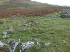
Yar Tor Tor Enclosure
OS Map: SX 67849 74046
HER: MDV128748
ShortName: EN Yar Tor
Butler map: 14.8
Notes: HER quoting Newman: A Tor enclosure of uncertain date on the northern outcrop of Yar Tor. This enclosure is situated in a natural avenue between two outcrops with vertical faces on the north and south sides which has been blocked off at the western and eastern ends by artificial stone walls. The western interior is approximately level but slopes away on the eastern side down to the wall. The north and south sides of the enclosure comprise natural linear crags of up to 2.0m high reinforced in places by large boulders. The wall at the western end is 2.1m thick and consists of a stone revetted bank with stone rubble behind surviving up to 0.8m high. The wall is slightly curved in plan. On the eastern wall there are vestiges of stone facing still in place but it is mostly collapsed and spread up to 3m wide and 0.7m high much of the wall surviving only as a disturbed stony spread. There is a possible entrance in the east wall adjacent to the northern outcrop, in the form of an opening. There are no discernable interior features.
The main photo is taken looking down from on top of one of the outcrops. Butler's possible round house can be seen within the main photo but see also a close up from ground level.
Acknowledgement: The author was unaware of this site until a walk with Steve Szypko on 25/09/2025. This record has been added as a result.
Nearby sites: SX 67849 74046
Distance: 1.92km

Corndon Tor 1 Cairn
OS Map: SX 68588 74227
HER: MDV6387
Megalithic Portal: 22982
ShortName: CN:CorndonTor
Butler map: 15.4.1
Barrow Report: 56 62
Notes: HER: Cairn on the summit of Corndon Tor, to the north of the main outcrop, comprising a large stony mound, constructed from moorstone with a truncated cone profile and no turf cover. Remains of a possible second cairn are located to the south on the outcrop.
Nearby sites: SX 68588 74227
Distance: 1.93km
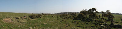
Cator Pound
Prehistoric Dartmoor Walks: Dartmoor Site: Cator Pound
OS Map: SX 6730 7765
HER: MDV6009
Megalithic Portal: 34961
ShortName: PD Cator Pound
Notes: HER: Cator pound, widecombe. In his survey of widecombe made about 1750, dean milles describes 'a very considerable circle of stones on the n part of the western down on a farm called cator and on an eminence called whitehill'; he gives the diameter as 58 paces and says it consisted 'chiefly of large stones mowst of which rise about 4 feet above ye ground. This circle consists now of about 30 stones but there are spaces where several more stood, half the number are fallen; the rest are either erect or on their sides'.
Nearby sites: SX 6730 7765
Distance: 1.74km

Cator Common Platform Cairn Circle and Cist
OS Map: SX 67118 77510
HER: MDV5987
Megalithic Portal: 45793
PMD: Pizwell Bridge
Alternate name: Pizwell Bridge Platform Cairn Circle and Cist
ShortName: CT Pizwell 1
Butler map: 18.5
Butler Vol 5: p.171 & Fig.110
Grinsell: WID 2
Turner: E10
Notes: "Pizwell Bridge cairn of circa 5m diameter by 0.5m high is to be found about 10m below the road in an unusual position near the base of the hill. Three retaining slabs form an arc around one side with another just under the turf. The top of a slab near the centre with a pit alongside might be one side of a cist. ". Butler Pizwell Bridge Vol. 1. Map 18.5 (diagram Vol 5. p.171). Possible central cist.
This feature can be seen from the road in the distance by a small tree but it is not on public access land and the area has a high fence surrounding it. The photo above was taken by Steve Szykpo and is reproduced with his kind permission.
Nearby sites: SX 67118 77510
Distance: 1.67km