
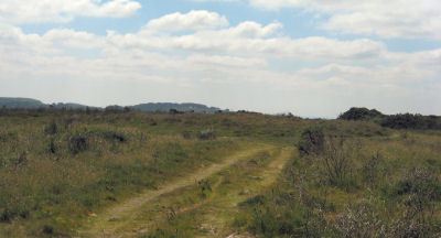
Prehistoric sites within 2km of SX 76760 87190
Guidance for walkers: The monuments featured in this database are archaeological treasures and need to be protected and preserved - please do not disturb any sites. Please check access and firing times before visiting sites, not all sites listed are on open access land. Firing ranges and boundaries of open access areas are marked on the OL28 OS Dartmoor Explorer map. Please stick to the country code and consider giving support to the numerous agencies that help to keep Dartmoor a fabulous natural and historic environment!
About the database listings: In all listings clicking on the photo or the site name will open a page for the site with a larger photo and further details from the database. The database now has over 6680 records covering nearly all publicly listed sites on Dartmoor including around 4800 round houses. This level of detail is of interest to archaeologists but tends to swamp listings of sites more likely to be of interest for walkers. For this reason, the listings default to around 550 core sites only. These are the stone circles, stone rows and the ring cairns listed by Turner. The default search radius is 2 km. The controls below the map can be used to start a new search by entering a 6- or 8-digit reference (without the prefix "SX"). The search radius can be specified and you can add incremental Display layers of detail on top of the core sites. If using a more detailed layer you will need to decrease the search radius to avoid getting hundreds of search results.
- Core sites Default listing of core sites consisting of stone circles & rows and some of the major ring cairns.
- Plus cairns adds approx. 1000 cairns and other minor sites not included in the core listings but excluding round houses.
- Plus round houses adds approx. 4800 round houses.
- Plus non-sites adds in the records for sites that no longer exist or are not prehistoric sites.
- Plus duplicates adds records excluded as duplicates. Those maybe duplicate records in external listings (e.g. the Historic Environment Records). For example, some sites have been identified as cairns in some listings and interpreted as round houses in other listings and both records appear.
These listings have incorporated, matched up and merged all of the records from all of the major archaeological listings including: Worth, Grinsell, Turner, Butler, Bill Radcliffe, Sandy Gerrard, Megalithic Portal, the National Monument Records and the Historic Environment Records. The author would like to thank Bill, Sandy, the lovely people both at Megalithic Portal (especially Anne Tate who did an amazing job to link listings) and at ACE Archaeology for collaborative work over the years to synchronise and correct listings across the various websites which now interlink. A culmination of years of work the final merger of cairn records took 3 months of cross referencing in 2017 the result being a snapshot of the records at that time. This data has in turn been refined since by field work and research. The round house data was supplied by Sandy Gerrard. Grid references are in order of accuracy: from Google Earth satellite, if visible and found, from a Garmin GPS reading, if visited by the author and from the literature otherwise. Individual site pages will state the source of the grid reference and provide satellite imagery. If a site listing lacks a photo it has not yet been visited by the author in which case the grid reference is from the literature.
Currently the database only includes sites which can be represented by a grid reference. Reaves are not included as they require GIS shape technology which is beyond the current capability of this system. To see the sources for the records, look at the tables on the resources menu. The database listings can also be viewed on a Google map and downloaded as GPS datasets for Garmin devices.
Corrections, or any feedback or suggestions are very welcome, email: info@dartmoorwalks.org.uk.
NOTE: Clicking on the icons for each monument in the map will give the name of the site. You can zoom in and out and drag the map around.
List of sites within 2km of SX 76760 87190
Blackpool (Mardon) Ancient Pool
Prehistoric Dartmoor Walks: Dartmoor Site: Mardon Down Stone Circle & Cairns
OS Map: SX 76757 87350
HER: MDV19004
ShortName: PO Blackpool
Notes: "Marked as an enclosure on historic mapping, this is actually a seasonal pond. Surveyed in 2017, its outline shape is unevenly rounded on the western end. Its appearance, with small scarped edges, suggest it was hand dug and large boulders around the edge have been left in situ. The hollow measures 22 metres by 17 metres but is only 0.5 metres deep. An alignment of small stones in the base of the hollow may be a more recent addition. There is no indication as to where material removed from the hollow was dumped. Cannot be confirmed for certain as a dewpond and no evidence was found for this ever having been the site of a ring cairn, as previously suggested. Recorded as Black Pool in 1912. Included in Greeves' list (2019) of 'sacred pools', with potentially prehistoric origins."
Nearby sites: SX 76757 87350
Distance: 0.16km
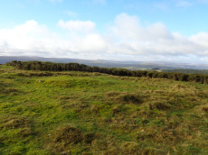
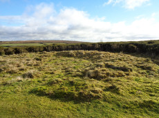
Giant's Grave Cairn
Prehistoric Dartmoor Walks: Dartmoor Site: Mardon Down Stone Circle & Cairns
OS Map: SX 76768 87459
HER: MDV8309
Megalithic Portal: 22314
Alternate name: Mardon Down 4 Cairn
ShortName: CN Mardon 4
Butler Vol 5: p.147 & Fig.89
DPD page: 149
Grinsell: MOR 3
Notes: Remains of a cairn which was largely destroyed in the early 19th century when material from it was removed for road building. Now a turf-covered mound 20.5 metres diameter and 0.6 metres high.
Grinsell [Folklore 1976]: Remains of an oval cairn with retaining kerb, on Mardon Down. The name dates from before 1823. Jones 1823, 3.
Nearby sites: SX 76768 87459
Distance: 0.27km
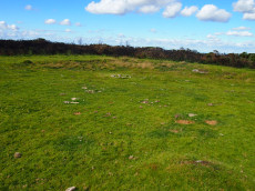
Mardon Down Stone Ring Cairn Circle
Prehistoric Dartmoor Walks: Dartmoor Site: Mardon Down Stone Circle & Cairns
OS Map: SX 76729 87264
HER: MDV19003
Megalithic Portal: 22313
PMD: Mardon Down Cairn 1
Alternate name: Mardon Down 2 Stone Ring Cairn Circle
ShortName: RC Mardon 2
DPD page: 149
Turner: A36
Notes: "Stone ring with central cairn. Outer ring measures 12.0 metres in diameter with bank 1.5 metres wide and 0.3 metres high. Central cairn 5.0 metres in diameter and 0.4 metres high with disturbance on its western side. Outer ring has 2.5 metre wide entrance on the east."
Nearby sites: SX 76729 87264
Distance: 0.08km
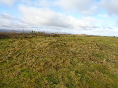
Mardon Down Platform Cairn Circle
Prehistoric Dartmoor Walks: Dartmoor Site: Mardon Down Stone Circle & Cairns
OS Map: SX 76759 87172
HER: MDV15158
Megalithic Portal: 22312
PMD: Mardon Down Cairn 1
Alternate name: Mardon Down 1 Platform Cairn Circle
ShortName: PC Mardon 1
Butler Vol 5: p.149 & Fig.91
DPD page: 149
Grinsell: MOR 5
Turner: E9
Notes: Platform circle consisting of a ring of kerb stones, measuring 7.0 metres in internal diameter, enclosing a flat-topped cairn 0.3 metres high, with boulder incorporated into perimeter.
Nearby sites: SX 76759 87172
Distance: 0.02km
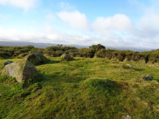
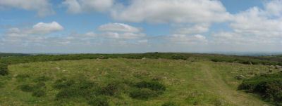
Mardon Down Embanked Cairn Circle
Prehistoric Dartmoor Walks: Dartmoor Site: Mardon Down Stone Circle & Cairns
OS Map: SX 76744 87691
HER: MDV8308
Megalithic Portal: 3375
Alternate name: Mardon Down Pillared Circle 5 Embanked Cairn Circle
ShortName: CC Mardon 5
Butler Vol 5: p.150 & Fig.92
DPD page: 149
Grinsell: MOR 1
Turner: B6
Notes: Impressive cairn circle with a well preserved ring of large pillars surrounded by an outer kerb ring of smaller slabs on their edges. The cairn is 11m. in diameter and 0.5m. high, with a well preserved cairn circle comprising a 9.0m. diameter circle of spaced uprights averaging 0.8m. high, with kerbing between. Unlike the stone circle it is marked on the OS Okehampton and North Dartmoor Landranger map (Sheet 191). It is easy to confuse this cairn with the less well preserved stone circle which is a few hundred metres to the south. Turner B6.
Nearby sites: SX 76744 87691
Distance: 0.50km
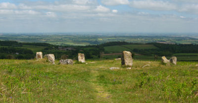
Mardon Down Stone Circle
Prehistoric Dartmoor Walks: Dartmoor Site: Mardon Down Stone Circle & Cairns
OS Map: SX 76764 87203
HER: MDV8289
Megalithic Portal: 3376
PMD: Mardon Down Stone Circle
ShortName: SC Mardon Down
Butler Vol 5: p.148 & Fig.90
DPD page: 149
Turner: G1
Notes: Mardon Down stone circle is the biggest by circumference on Dartmoor with a diameter of 38m. The site would have been impressive in its day and is one of the only ones sited on the top of high ground and has a fine view of the surrounding area. Today the circle is fairly dilapidated. Six stones remain upright and another 16 lie roughly in place. There are two massive megaliths one of which is on the north-western part of the circle. A short arc of seven stones remains in position on the south-east of the circle. The circle was first described by Dr Milles in 1772 who reported around 70 stones. Butler suggests it probably originally consisted of around 61 stones many of which are probably buried under the peat where they originally fell although some have no doubt been robbed out.
Nearby sites: SX 76764 87203
Distance: 0.01km
Mardon Down (E) Stone Ring Cairn Circle
Prehistoric Dartmoor Walks: Dartmoor Site: Mardon Down Stone Circle & Cairns
OS Map: SX 76894 87602
HER: MDV12771
Megalithic Portal: 45824
ShortName: RC Mardon East
Butler Vol 5: p.147 & Fig.89
DPD page: 149
Turner: A10
Notes: HER: Earthwork lying 150 metres east of the summit ridge, probably a robbed cairn or enclosure, comprising a curving stony bank forming the outline suggestive of an approximate circle. Badly damaged on the north and north-east sides and mostly effaced on the west by a path.
Nearby sites: SX 76894 87602
Distance: 0.43km
Mardon Down S.E. of Giants Grave Cairn Circle
Prehistoric Dartmoor Walks: Dartmoor Site: Mardon Down Stone Circle & Cairns
OS Map: SX 76774 87432
HER: MDV8310
Megalithic Portal: 22315
Alternate name: Mardon Down 3 Cairn Circle
ShortName: CC Mardon 3
Butler Vol 5: p.147 & Fig.89
Grinsell: MOR 4
Notes: NMR C. Cairn 32.0 metres south-east of Giant's Grave. 11.0 metres diameter, 0.7 metres high with traces of a retaining circle on the south-west side.
Nearby sites: SX 76774 87432
Distance: 0.24km
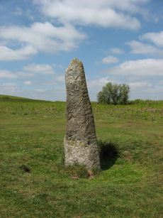
Maximajor Stone Standing Stone
Prehistoric Dartmoor Walks: Dartmoor Site: Mardon Down Stone Circle & Cairns
OS Map: SX 77076 87818
HER: MDV8281
Megalithic Portal: 22324
PMD: Headless Cross Standing Stone
ShortName: SS Maximajor
Notes: Situated on Mardon Moor, the Headless Cross, or Maximajor Stone, despite its name, was never a cross. It was a megalith although apparently the current stone is a replacement for the original which was damaged beyond repair by a car. See also: Legendary Dartmoor: The Maximajor Stone
Nearby sites: SX 77076 87818
Distance: 0.70km