
Prehistoric sites within 2km of SX 75800 89700
Guidance for walkers: The monuments featured in this database are archaeological treasures and need to be protected and preserved - please do not disturb any sites. Please check access and firing times before visiting sites, not all sites listed are on open access land. Firing ranges and boundaries of open access areas are marked on the OL28 OS Dartmoor Explorer map. Please stick to the country code and consider giving support to the numerous agencies that help to keep Dartmoor a fabulous natural and historic environment!
About the database listings: In all listings clicking on the photo or the site name will open a page for the site with a larger photo and further details from the database. The database now has over 6680 records covering nearly all publicly listed sites on Dartmoor including around 4800 round houses. This level of detail is of interest to archaeologists but tends to swamp listings of sites more likely to be of interest for walkers. For this reason, the listings default to around 550 core sites only. These are the stone circles, stone rows and the ring cairns listed by Turner. The default search radius is 2 km. The controls below the map can be used to start a new search by entering a 6- or 8-digit reference (without the prefix "SX"). The search radius can be specified and you can add incremental Display layers of detail on top of the core sites. If using a more detailed layer you will need to decrease the search radius to avoid getting hundreds of search results.
- Core sites Default listing of core sites consisting of stone circles & rows and some of the major ring cairns.
- Plus cairns adds approx. 1000 cairns and other minor sites not included in the core listings but excluding round houses.
- Plus round houses adds approx. 4800 round houses.
- Plus non-sites adds in the records for sites that no longer exist or are not prehistoric sites.
- Plus duplicates adds records excluded as duplicates. Those maybe duplicate records in external listings (e.g. the Historic Environment Records). For example, some sites have been identified as cairns in some listings and interpreted as round houses in other listings and both records appear.
These listings have incorporated, matched up and merged all of the records from all of the major archaeological listings including: Worth, Grinsell, Turner, Butler, Bill Radcliffe, Sandy Gerrard, Megalithic Portal, the National Monument Records and the Historic Environment Records. The author would like to thank Bill, Sandy, the lovely people both at Megalithic Portal (especially Anne Tate who did an amazing job to link listings) and at ACE Archaeology for collaborative work over the years to synchronise and correct listings across the various websites which now interlink. A culmination of years of work the final merger of cairn records took 3 months of cross referencing in 2017 the result being a snapshot of the records at that time. This data has in turn been refined since by field work and research. The round house data was supplied by Sandy Gerrard. Grid references are in order of accuracy: from Google Earth satellite, if visible and found, from a Garmin GPS reading, if visited by the author and from the literature otherwise. Individual site pages will state the source of the grid reference and provide satellite imagery. If a site listing lacks a photo it has not yet been visited by the author in which case the grid reference is from the literature.
Currently the database only includes sites which can be represented by a grid reference. Reaves are not included as they require GIS shape technology which is beyond the current capability of this system. To see the sources for the records, look at the tables on the resources menu. The database listings can also be viewed on a Google map and downloaded as GPS datasets for Garmin devices.
Corrections, or any feedback or suggestions are very welcome, email: info@dartmoorwalks.org.uk.
NOTE: Clicking on the icons for each monument in the map will give the name of the site. You can zoom in and out and drag the map around.
List of sites within 2km of SX 75800 89700
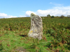
Butterdon Hill (nr. Moretonhampstead) Standing Stone
Prehistoric Dartmoor Walks: Dartmoor Walk: Butterdon Hill (nr Moretonhampstead) Standing Stone
OS Map: SX 74784 88403
HER: MDV8278
Megalithic Portal: 33950
PMD: Butterdon Down Standing Stone
Alternate name: Butterdon Down Standing Stone
ShortName: SS Butter Down
Notes: HER quoting J. V. S. Cocks Standing stone - prob. prehistoric. An upright stone, stands at the west edge of Butterdon Down, Moretonhampstead, beside the public footpath, 600 yards from Cranbrook Farm. It is between six and seven feet high and of slightly curved slab shape. Ref: Devon & Cornwall Notes & Queries 31 1970 pp. 225-26.
Nearby sites: SX 74784 88403
Distance: 1.65km
Prestonbury Castle Fort
Prehistoric Dartmoor Walks: Dartmoor Resource: Table of Devon Iron Age Forts
OS Map: SX 74683 90025
HER: MDV8439
Megalithic Portal: 29170
ShortName: FT:Prestonbury
Notes: "Iron Age hillfort, inner works complete, but possibly outer works never finished. Prestonbury Castle is situated three miles north-west of Moretonhampstead high above the north bank of the R Teign. The bank of the inner enclosure measures 418 feet by 410 feet and is 7 1/2 feet high with entrances to the east and west. The middle enclosure bank has a simple entrance on its east side. The outer bank, only partially extant, is strengthened by a rock-cut ditch 20 feet broad. This bank divides into two at the crest of the southern slope. The bank has an inturned entrance facing northeas"
Nearby sites: SX 74683 90025
Distance: 1.16km
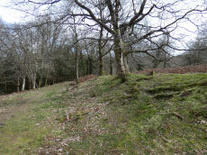
Wooston Castle Fort
Prehistoric Dartmoor Walks: Dartmoor Resource: Table of Devon Iron Age Forts
OS Map: SX 76486 89673
HER: MDV8292
Megalithic Portal: 7767
ShortName: FT:Wooston
Notes: HER: Wooston Castle comprises a defensive enclosure approached through a series of outworks which extend for up to 200 metres from east to west. From south to north the whole complex covers some 500 metres, at the northern extremity the defences lie within 50 metres of a precipitous drop to the River Teign. Excavation in 2018 revealed information on the construction of the ditches and banks but found no dateable evidence to confirm the assumed Iron Age date of the site.
Nearby sites: SX 76486 89673
Distance: 0.69km