
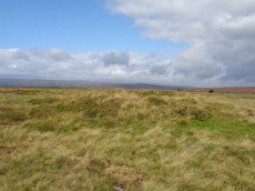
Prehistoric sites within 2km of SX 72200 77900
Guidance for walkers: The monuments featured in this database are archaeological treasures and need to be protected and preserved - please do not disturb any sites. Please check access and firing times before visiting sites, not all sites listed are on open access land. Firing ranges and boundaries of open access areas are marked on the OL28 OS Dartmoor Explorer map. Please stick to the country code and consider giving support to the numerous agencies that help to keep Dartmoor a fabulous natural and historic environment!
About the database listings: In all listings clicking on the photo or the site name will open a page for the site with a larger photo and further details from the database. The database now has over 6680 records covering nearly all publicly listed sites on Dartmoor including around 4800 round houses. This level of detail is of interest to archaeologists but tends to swamp listings of sites more likely to be of interest for walkers. For this reason, the listings default to around 550 core sites only. These are the stone circles, stone rows and the ring cairns listed by Turner. The default search radius is 2 km. The controls below the map can be used to start a new search by entering a 6- or 8-digit reference (without the prefix "SX"). The search radius can be specified and you can add incremental Display layers of detail on top of the core sites. If using a more detailed layer you will need to decrease the search radius to avoid getting hundreds of search results.
- Core sites Default listing of core sites consisting of stone circles & rows and some of the major ring cairns.
- Plus cairns adds approx. 1000 cairns and other minor sites not included in the core listings but excluding round houses.
- Plus round houses adds approx. 4800 round houses.
- Plus non-sites adds in the records for sites that no longer exist or are not prehistoric sites.
- Plus duplicates adds records excluded as duplicates. Those maybe duplicate records in external listings (e.g. the Historic Environment Records). For example, some sites have been identified as cairns in some listings and interpreted as round houses in other listings and both records appear.
These listings have incorporated, matched up and merged all of the records from all of the major archaeological listings including: Worth, Grinsell, Turner, Butler, Bill Radcliffe, Sandy Gerrard, Megalithic Portal, the National Monument Records and the Historic Environment Records. The author would like to thank Bill, Sandy, the lovely people both at Megalithic Portal (especially Anne Tate who did an amazing job to link listings) and at ACE Archaeology for collaborative work over the years to synchronise and correct listings across the various websites which now interlink. A culmination of years of work the final merger of cairn records took 3 months of cross referencing in 2017 the result being a snapshot of the records at that time. This data has in turn been refined since by field work and research. The round house data was supplied by Sandy Gerrard. Grid references are in order of accuracy: from Google Earth satellite, if visible and found, from a Garmin GPS reading, if visited by the author and from the literature otherwise. Individual site pages will state the source of the grid reference and provide satellite imagery. If a site listing lacks a photo it has not yet been visited by the author in which case the grid reference is from the literature.
Currently the database only includes sites which can be represented by a grid reference. Reaves are not included as they require GIS shape technology which is beyond the current capability of this system. To see the sources for the records, look at the tables on the resources menu. The database listings can also be viewed on a Google map and downloaded as GPS datasets for Garmin devices.
Corrections, or any feedback or suggestions are very welcome, email: info@dartmoorwalks.org.uk.
NOTE: Clicking on the icons for each monument in the map will give the name of the site. You can zoom in and out and drag the map around.
List of sites within 2km of SX 72200 77900
Blackaton Down N. Cairn
OS Map: SX 70683 79094
HER: MDV7413
Megalithic Portal: 16633
ShortName: CN Blackaton N
Butler map: 20.12.1
Butler Vol 5: p.193 & Fig.137
Grinsell: WID 4
Notes: The earthwork remains of two Bronze Age cairns. 'B' is a cairn 42 feet in diameter and 3 feet high. Cairn with small hollow towards centre. Butler Volume 1 Map 20.12.
Nearby sites: SX 70683 79094
Distance: 1.93km
Blackaton Down S. Cairn
OS Map: SX 70732 79047
HER: MDV7412
Megalithic Portal: 16634
ShortName: CN:Blackaton S
Butler map: 20.12.2
Butler Vol 5: p.192 & Fig.136
Grinsell: WID 5
Notes: ['A' SX 7073 7904]. Tumuli on saddle, 'A' is 40 feet in diameter with a rim 1 ft. high. One of pair of cairns, this one is concave or "saucer" shaped. Butler Volume 1 Map 20.12.
Nearby sites: SX 70732 79047
Distance: 1.86km
Blackaton Newtake (Hameldown) Ancient Pool
OS Map: SX 70785 78973
HER: MDV7527
ShortName: PO:Hameldown
Notes: Previously recorded as a possible cairn (was listed here as Hameldown 2 Reported Cairn), although identification noted later as 'doubtful' - water filled depression with a few surface stones. Identified as one of the 40+ 'sacred pool' sites on the moor, possibly dating from the Prehistoric period.
Nearby sites: SX 70785 78973
Distance: 1.78km
Bonehill Down Ancient Pool
OS Map: SX 73282 77812
HER: MDV127194
ShortName: PO:BonehillDn
Notes: "The pool on Bonehill Down measures 12 by 6m. One of over 40 such 'sacred' pools identified on Dartmoor that are thought to have potentially been designed during the prehistoric period."
Nearby sites: SX 73282 77812
Distance: 1.09km
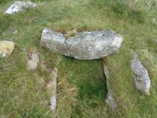
Hameldon Cist
OS Map: SX 71008 78345
HER: MDV7519
Megalithic Portal: 16636
PMD: Hamel Down S.
Alternate name: Hamel Down S. Cist
ShortName: CT Hameldon
Butler map: 20.15
Butler Vol 5: p.178 & Fig.120
DPD page: 129
Grinsell: WID 7
Barrow Report: 54
Notes: Precise location originally unsurveyed but given approximately by Worth as SX 71257908. This may explain the large discrepancy between the NMR position and that given by Butler and in the HER. Three sides of the cist are visible with the fourth having sunken below the earth. The capstone is incomplete and only partly covers the cavity. Lethbridge diagram p129 and photo top p.129. Butler Hamel Down 15 (S) - Vol. 1. Map 20.15 (Cairn 15 p.149, diagram Vol 5. p.178).
Nearby sites: SX 71008 78345
Distance: 1.27km
Hameldown Beacon Cairn
OS Map: SX 70830 78922
HER: MDV7435
Megalithic Portal: 16635
Alternate name: Hamel Down Beacon Cairn
ShortName: CN HamelBeacon
Butler map: 20.13
Butler Vol 5: p.166 & Fig.106
Grinsell: WID 6
Notes: A grass covered cairn which was alleged to have been used as a beacon in medieval period. Butler Volume 1 Map 20.13
Nearby sites: SX 70830 78922
Distance: 1.71km
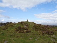
Top Tor Cairn
OS Map: SX 73574 76472
HER: MDV7455
Megalithic Portal: 32049
Alternate name: Top Tor 1 Cairn
ShortName: CN:Top Tor 1
Butler map: 9.7.1
Grinsell: WID 11
Notes: NMR C. "Cairns on Top Tor. Two inconspicuous cairns lie about 80 metres apart beside the track which follows the crest of the ridge on the north side of Top Tor. The cairn to the south is smaller at circa 7.5 metres diameter by 0.2 metres high and has a circle of ten slabs showing above the turf around the edge. This cairn has been reported to have a stone row running downhill to the north but the few earthfast slabs in this direction are no more numerous than elsewhere on the hillside and this seems unconvincing. Nearly 100 metres east of the southern cairn is an arc of three standing and two flat slabs representing about a quarter of a circle. The interior is quite flat except for a shallow trench but possibly the stones originally surrounded a cairn which has been completely removed. Other details: Map 9, Site 7."
Nearby sites: SX 73574 76472
Distance: 1.98km