
Prehistoric sites within 2km of SX 67850 83640
Guidance for walkers: The monuments featured in this database are archaeological treasures and need to be protected and preserved - please do not disturb any sites. Please check access and firing times before visiting sites, not all sites listed are on open access land. Firing ranges and boundaries of open access areas are marked on the OL28 OS Dartmoor Explorer map. Please stick to the country code and consider giving support to the numerous agencies that help to keep Dartmoor a fabulous natural and historic environment!
About the database listings: In all listings clicking on the photo or the site name will open a page for the site with a larger photo and further details from the database. The database now has over 6680 records covering nearly all publicly listed sites on Dartmoor including around 4800 round houses. This level of detail is of interest to archaeologists but tends to swamp listings of sites more likely to be of interest for walkers. For this reason, the listings default to around 550 core sites only. These are the stone circles, stone rows and the ring cairns listed by Turner. The default search radius is 2 km. The controls below the map can be used to start a new search by entering a 6- or 8-digit reference (without the prefix "SX"). The search radius can be specified and you can add incremental Display layers of detail on top of the core sites. If using a more detailed layer you will need to decrease the search radius to avoid getting hundreds of search results.
- Core sites Default listing of core sites consisting of stone circles & rows and some of the major ring cairns.
- Plus cairns adds approx. 1000 cairns and other minor sites not included in the core listings but excluding round houses.
- Plus round houses adds approx. 4800 round houses.
- Plus non-sites adds in the records for sites that no longer exist or are not prehistoric sites.
- Plus duplicates adds records excluded as duplicates. Those maybe duplicate records in external listings (e.g. the Historic Environment Records). For example, some sites have been identified as cairns in some listings and interpreted as round houses in other listings and both records appear.
These listings have incorporated, matched up and merged all of the records from all of the major archaeological listings including: Worth, Grinsell, Turner, Butler, Bill Radcliffe, Sandy Gerrard, Megalithic Portal, the National Monument Records and the Historic Environment Records. The author would like to thank Bill, Sandy, the lovely people both at Megalithic Portal (especially Anne Tate who did an amazing job to link listings) and at ACE Archaeology for collaborative work over the years to synchronise and correct listings across the various websites which now interlink. A culmination of years of work the final merger of cairn records took 3 months of cross referencing in 2017 the result being a snapshot of the records at that time. This data has in turn been refined since by field work and research. The round house data was supplied by Sandy Gerrard. Grid references are in order of accuracy: from Google Earth satellite, if visible and found, from a Garmin GPS reading, if visited by the author and from the literature otherwise. Individual site pages will state the source of the grid reference and provide satellite imagery. If a site listing lacks a photo it has not yet been visited by the author in which case the grid reference is from the literature.
Currently the database only includes sites which can be represented by a grid reference. Reaves are not included as they require GIS shape technology which is beyond the current capability of this system. To see the sources for the records, look at the tables on the resources menu. The database listings can also be viewed on a Google map and downloaded as GPS datasets for Garmin devices.
Corrections, or any feedback or suggestions are very welcome, email: info@dartmoorwalks.org.uk.
NOTE: Clicking on the icons for each monument in the map will give the name of the site. You can zoom in and out and drag the map around.
List of sites within 2km of SX 67850 83640
Bush Down Settlement
OS Map: SX 6849 8217
HER: MDV6596
Megalithic Portal: 7699
ShortName: ST:BushDown
Nearby sites: SX 6849 8217
Distance: 1.60km
East Lowton Settlement
OS Map: SX 666 837
HER: MDV107002
Megalithic Portal: 34966
ShortName: ST:EastLowton
Nearby sites: SX 666 837
Distance: 1.25km
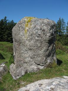
Heath Stone Standing Stone
Prehistoric Dartmoor Walks: Dartmoor Site: Hurston Ridge Double Stone Row
OS Map: SX 67133 83755
HER: MDV6650
Megalithic Portal: 14933
ShortName: SS Heath Stone
Butler map: 25.
Notes: The original Heath Stone was a boundary stone which was referred to in the Perambulation of the Forest of Dartmoor in 1240 and some very early maps. According to Butler (Vol. 2 Map 25 p.32) the stone carved with a biblical inscription in 1970 that is currently known as the Heath Stone is unlikely to have been the original Heath Stone as it is in a useless position to be of any use as a boundary stone. The stone was not included in maps from the 18th century and then reappeared in a different location. It is doubtful that the current stone is the original or that it is prehistoric. Crossing suggests that the large standing stone in the Hurston Ridge stone row is the actual Heath Stone. See also, Legendary Dartmoor: The Dartmoor Heathstone
Nearby sites: SX 67133 83755
Distance: 0.73km
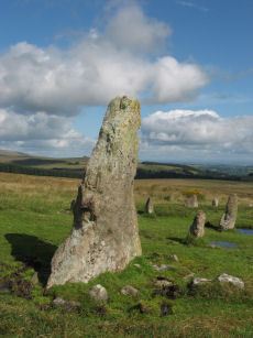
Hurston Ridge Standing Stone
Prehistoric Dartmoor Walks: Dartmoor Site: Hurston Ridge Double Stone Row
OS Map: SX 67268 82444
HER: MDV6541
Megalithic Portal: 8345
PMD: Hurston Ridge Standing Stone
ShortName: SS Hurston
Butler map: 25.9
DPD page: 136
Notes: Hurston Ridge is one of the best examples of a double stone now on Dartmoor. At the south end is a cairn 22 feet in diameter. The space between the rows widens intentionally as it approaches the cairn. The first stone from the south in the eastern row is the largest stone and stands 5 feet 10 inches high. Crossing suggests this may have been the original Heath Stone.
Nearby sites: SX 67268 82444
Distance: 1.33km

Hurston Ridge Settlement
OS Map: SX 674 825
HER: MDV6668
Megalithic Portal: 34979
ShortName: ST Hurston
Butler map: 25.9
Nearby sites: SX 674 825
Distance: 1.23km
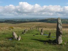
Hurston Ridge Stone Row
Prehistoric Dartmoor Walks: Dartmoor Site: Hurston Ridge Double Stone Row
OS Map: SX 67260 82437
HER: MDV6541
Megalithic Portal: 8345
The Stone Rows of GB: Hurston Ridge
PMD: Hurston Ridge Stone Row
ShortName: SR Hurston
Butler map: 25.9
Butler Vol 5: p.228 & Fig.161
DPD page: 136
Notes: .Worth: Watern Hill. "A stone alignment which includes two parallel lines of upright stones leading downslope for 143 metres from a round cairn. The lower end of the alignment is denoted by a blocking stone. Midway along the alignment a length of later enclosure walling crosses the row. The cairn at the upper end of the alignment measures 5.9 metres in diameter and stands up to a height of 0.6 metres. A large slab denoting the north eastern edge of the cairn may represent a second blocking stone of the associated alignment." A number of the stones were restored to their original sockets in 1894. A broken hand axe was discovered in the pit in which one of the stones had stood near to the menhir next to the cairn. First observed by Mr. George French of Postbridge.
Nearby sites: SX 67260 82437
Distance: 1.34km
Lowton Brook W. Settlement
OS Map: SX 663 834
HER: MDV104672
Megalithic Portal: 24262
ShortName: ST:LowtonBkW
Nearby sites: SX 663 834
Distance: 1.57km
Metherall Settlement
OS Map: SX 668 840
HER: MDV107529
Megalithic Portal: 15138
ShortName: ST:Metherall
Barrow Report: 56
Nearby sites: SX 668 840
Distance: 1.11km
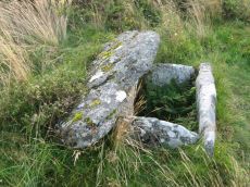
Thornworthy Cist
OS Map: SX 66746 84348
HER: MDV6613
Megalithic Portal: 15453
PMD: Thornworthy
ShortName: CT Thornworthy
Butler map: 35.22
Butler Vol 5: p.64 & Fig.42
DPD page: 137
Grinsell: CHA 3
Turner: E39
Barrow Report: 16 21 56
Notes: Butler Vol. 2. Map 35.22 (p.169, photo on p.136, diagram Vol. 5. p.64).Originally there was a second slightly smaller cist. This was removed after the excavation and re-erected at Torquay Museum. It is now at the High Moorland Visitor Centre at Princetown. See also: Thornworthy 2 Cist
Nearby sites: SX 66746 84348
Distance: 1.31km

West Vitifer Cist
OS Map: SX 67575 82802
HER: MDV6615
Megalithic Portal: 34980
PMD: Chagford Common
ShortName: CT WestVitif 1
Butler map: 25.11
Grinsell: CHA 4
Barrow Report: 16
Notes: "Possible location of a Bronze Age cist, although when subject to field investigation in November 2002 the site was not found" "The cairn was partially excavated in 1897 by the Barrow Committee of the Devonshire Association. This working revealed a ring of slabs surrounding a cist which had not been previously examined. In the cist there was a complete Bronze Age beaker together with charcoal but no trace of a burial."
Nearby sites: SX 67575 82802
Distance: 0.88km

Yardworthy Stone Row
OS Map: SX 67605 84395
HER: MDV61337
Megalithic Portal: 6333471
The Stone Rows of GB: Yardworthy
PMD: Yardworthy
ShortName: SR Yardworthy
Notes: Quinnell quoted on HER: Stone row in Yardworthy Newtake, an area of rough pasture that has since undergone some stone clearance. Apparently the remains of a double row it starts 3.0 metres from a low barrow at SX67608438 and extends to the north-east for 7.0 metres. The north-west side consists of four stones, 2.0 to 2.5 metres apart. The south-eastern side about 1.4 metres distant has only one stone and two turf humps which may conceal others. Visible stones are barely 0.1 metres high. Immediately beyond the north-east end is a hollow or stone pit about 4.0 by 2.0 metres diameter. This, and clearance in the area may have destroyed any continuation.
Nearby sites: SX 67605 84395
Distance: 0.79km