
Prehistoric sites within 2km of SX 55100 86700
Guidance for walkers: The monuments featured in this database are archaeological treasures and need to be protected and preserved - please do not disturb any sites. Please check access and firing times before visiting sites, not all sites listed are on open access land. Firing ranges and boundaries of open access areas are marked on the OL28 OS Dartmoor Explorer map. Please stick to the country code and consider giving support to the numerous agencies that help to keep Dartmoor a fabulous natural and historic environment!
About the database listings: In all listings clicking on the photo or the site name will open a page for the site with a larger photo and further details from the database. The database now has over 6680 records covering nearly all publicly listed sites on Dartmoor including around 4800 round houses. This level of detail is of interest to archaeologists but tends to swamp listings of sites more likely to be of interest for walkers. For this reason, the listings default to around 550 core sites only. These are the stone circles, stone rows and the ring cairns listed by Turner. The default search radius is 2 km. The controls below the map can be used to start a new search by entering a 6- or 8-digit reference (without the prefix "SX"). The search radius can be specified and you can add incremental Display layers of detail on top of the core sites. If using a more detailed layer you will need to decrease the search radius to avoid getting hundreds of search results.
- Core sites Default listing of core sites consisting of stone circles & rows and some of the major ring cairns.
- Plus cairns adds approx. 1000 cairns and other minor sites not included in the core listings but excluding round houses.
- Plus round houses adds approx. 4800 round houses.
- Plus non-sites adds in the records for sites that no longer exist or are not prehistoric sites.
- Plus duplicates adds records excluded as duplicates. Those maybe duplicate records in external listings (e.g. the Historic Environment Records). For example, some sites have been identified as cairns in some listings and interpreted as round houses in other listings and both records appear.
These listings have incorporated, matched up and merged all of the records from all of the major archaeological listings including: Worth, Grinsell, Turner, Butler, Bill Radcliffe, Sandy Gerrard, Megalithic Portal, the National Monument Records and the Historic Environment Records. The author would like to thank Bill, Sandy, the lovely people both at Megalithic Portal (especially Anne Tate who did an amazing job to link listings) and at ACE Archaeology for collaborative work over the years to synchronise and correct listings across the various websites which now interlink. A culmination of years of work the final merger of cairn records took 3 months of cross referencing in 2017 the result being a snapshot of the records at that time. This data has in turn been refined since by field work and research. The round house data was supplied by Sandy Gerrard. Grid references are in order of accuracy: from Google Earth satellite, if visible and found, from a Garmin GPS reading, if visited by the author and from the literature otherwise. Individual site pages will state the source of the grid reference and provide satellite imagery. If a site listing lacks a photo it has not yet been visited by the author in which case the grid reference is from the literature.
Currently the database only includes sites which can be represented by a grid reference. Reaves are not included as they require GIS shape technology which is beyond the current capability of this system. To see the sources for the records, look at the tables on the resources menu. The database listings can also be viewed on a Google map and downloaded as GPS datasets for Garmin devices.
Corrections, or any feedback or suggestions are very welcome, email: info@dartmoorwalks.org.uk.
NOTE: Clicking on the icons for each monument in the map will give the name of the site. You can zoom in and out and drag the map around.
List of sites within 2km of SX 55100 86700
Little Links Tor 1 Cairn
OS Map: SX 5428 8747
HER: MDV51428
ShortName: CN:LittleLink1
Notes: HER: Ring cairn. Survives as a circular bank 2m wide and 0.4m high surrounding an internal area measuring 13m in diameter. A 3m wide gap in the western side of the bank may be the result of partial robbing. This ring cairn is of the unrevetted without central mound variety.
Nearby sites: SX 5428 8747
Distance: 1.12km
Little Links Tor 2 Cairn
OS Map: SX 54291 87520
HER: MDV125847
ShortName: CN:LittleLink2
Notes: HER quoting Greeves: Apparently unrecorded prehistoric cairn in the upper reaches of the River Lyd, approximately 150 metres north of the Smallacombe valley. Located at SX 54291 87520, approximately 30 metres north-west of ring cairn MDV51428. It is a low cairn mound with a relatively level top, no more than about 0.30 metres in height, approximately 10 metres by 9.0 metres in diameter.
It lies not far north of the stone alignment MDV51434, which due to the significant amount of prehistoric activity in this area, is likely to be a prehistoric stone row.
Nearby sites: SX 54291 87520
Distance: 1.15km
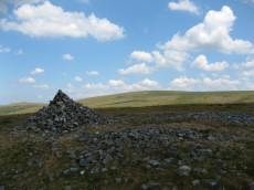
Great Links Tor Cairn
OS Map: SX 54922 86496
HER: MDV4653
Megalithic Portal: 10043
ShortName: CN:GreatLinks
Butler map: 43.13
Grinsell: BRI 8
Notes: "cairn with hollow in centre. Diam 17.5m, height 1.6m. ... (grinsell) 18.0m diameter, 1.4m high. Siting - hillspur. ... (gerrard) cairn mound measures 19m in diameter and stands up to 1.5m high. An irregular shaped hollow in the centre of the mound, measuring 4m long, 3m wide and up to 1.3m deep, suggests partial early excavation or robbing (mpp)."
Nearby sites: SX 54922 86496
Distance: 0.27km
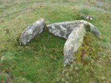
Doe Tor Cist
OS Map: SX 54383 84846
HER: MDV3251
Megalithic Portal: 44223
PMD: Doe Tor
Alternate name: Doe Tor E. Cist
ShortName: CT Doe Tor
Butler map: 32.21
Butler Vol 5: p.198 & Fig.141
DPD page: 10
Grinsell: LYD 12
Barrow Report: 24
Notes: Butler Doe Tor E - Vol. 2. Map 32.21 (diagram Vol. 5. p.198).
Nearby sites: SX 54383 84846
Distance: 1.99km
Great Nodden Cist
OS Map: SX 5388 8741
HER: MDV4625
Megalithic Portal: 45796
PMD: Great Nodden
Alternate name: Great Nodden 17 Cist
ShortName: CT Great Nod17
Butler map: 43.7.17
Grinsell: BRI 7a
Barrow Report: 13 21
Notes: Butler: "recorded on the summit in 1891". This was excavated revealing a cist. No longer traceable. This cairn and cist was around 6m away from the Great Nodden cairn. The photograph accompanying this record is of the Great Nodden Cairn in the vicinity of where this cist used to exist. Butler Vol. 2. Map 43.7.17.
Nearby sites: SX 5388 8741
Distance: 1.41km