
Prehistoric sites within 2km of SX 57360 60790
Guidance for walkers: The monuments featured in this database are archaeological treasures and need to be protected and preserved - please do not disturb any sites. Please check access and firing times before visiting sites, not all sites listed are on open access land. Firing ranges and boundaries of open access areas are marked on the OL28 OS Dartmoor Explorer map. Please stick to the country code and consider giving support to the numerous agencies that help to keep Dartmoor a fabulous natural and historic environment!
About the database listings: In all listings clicking on the photo or the site name will open a page for the site with a larger photo and further details from the database. The database now has over 6680 records covering nearly all publicly listed sites on Dartmoor including around 4800 round houses. This level of detail is of interest to archaeologists but tends to swamp listings of sites more likely to be of interest for walkers. For this reason, the listings default to around 550 core sites only. These are the stone circles, stone rows and the ring cairns listed by Turner. The default search radius is 2 km. The controls below the map can be used to start a new search by entering a 6- or 8-digit reference (without the prefix "SX"). The search radius can be specified and you can add incremental Display layers of detail on top of the core sites. If using a more detailed layer you will need to decrease the search radius to avoid getting hundreds of search results.
- Core sites Default listing of core sites consisting of stone circles & rows and some of the major ring cairns.
- Plus cairns adds approx. 1000 cairns and other minor sites not included in the core listings but excluding round houses.
- Plus round houses adds approx. 4800 round houses.
- Plus non-sites adds in the records for sites that no longer exist or are not prehistoric sites.
- Plus duplicates adds records excluded as duplicates. Those maybe duplicate records in external listings (e.g. the Historic Environment Records). For example, some sites have been identified as cairns in some listings and interpreted as round houses in other listings and both records appear.
These listings have incorporated, matched up and merged all of the records from all of the major archaeological listings including: Worth, Grinsell, Turner, Butler, Bill Radcliffe, Sandy Gerrard, Megalithic Portal, the National Monument Records and the Historic Environment Records. The author would like to thank Bill, Sandy, the lovely people both at Megalithic Portal (especially Anne Tate who did an amazing job to link listings) and at ACE Archaeology for collaborative work over the years to synchronise and correct listings across the various websites which now interlink. A culmination of years of work the final merger of cairn records took 3 months of cross referencing in 2017 the result being a snapshot of the records at that time. This data has in turn been refined since by field work and research. The round house data was supplied by Sandy Gerrard. Grid references are in order of accuracy: from Google Earth satellite, if visible and found, from a Garmin GPS reading, if visited by the author and from the literature otherwise. Individual site pages will state the source of the grid reference and provide satellite imagery. If a site listing lacks a photo it has not yet been visited by the author in which case the grid reference is from the literature.
Currently the database only includes sites which can be represented by a grid reference. Reaves are not included as they require GIS shape technology which is beyond the current capability of this system. To see the sources for the records, look at the tables on the resources menu. The database listings can also be viewed on a Google map and downloaded as GPS datasets for Garmin devices.
Corrections, or any feedback or suggestions are very welcome, email: info@dartmoorwalks.org.uk.
NOTE: Clicking on the icons for each monument in the map will give the name of the site. You can zoom in and out and drag the map around.
List of sites within 2km of SX 57360 60790
Crownhill Tor Fields Reported Cairn
OS Map: SX 5736 6079
HER: MDV12927
ShortName: CNxCrownhill21
Butler map: 52.16.1
Notes: Probably a clearance mound
Nearby sites: SX 5736 6079
Distance: 0.00km
Crownhill Down W.5 Cairn
OS Map: SX 5625 5981
HER: MDV12658
ShortName: CN:Crownhill2
Butler map: 52.16.5
Nearby sites: SX 5625 5981
Distance: 1.48km
Crownhill Down W.6 Cairn
OS Map: SX 5679 5988
HER: MDV20151
ShortName: CN:Crownhill3
Butler map: 52.16.6
Grinsell: SHA 47
Notes: Cairn with hollow at centre found on sparkwell boundary.
Nearby sites: SX 5679 5988
Distance: 1.07km
Crownhill Down Reported Cist
OS Map: SX 57 60
ShortName: CT?Crownhill1
Butler map: 52.16.6
Grinsell: SPA 8a
Notes: From a barrow 'destroyed many years since' came a large flint scraper and flint flakes PLYM Brent 1886. See. TDA 1886 Vol 18 p.74. Butler suggests that perhaps Brent's cairn was either 52.16.5 or 52.16.6.
"Crown Hill Down.—Amongst the rubbish and stones that had been removed and thrown down from a large circular barrow, that had been destroyed many years since, I found a large rude scraper of flint, and some broken pieces, all much weathered from exposure"
Nearby sites: SX 57 60
Distance: 0.87km
Crownhill Ridge 1 Cairn
OS Map: SX 5723 5973
HER: MDV1788
ShortName: CN:Crownhill4
Butler map: 52.16.7.1
Grinsell: SPA 7
Notes: NMR I
Nearby sites: SX 5723 5973
Distance: 1.07km
Crownhill Ridge 2 Cairn
OS Map: SX 5723 5975
HER: MDV1787
ShortName: CN:Crownhill9
Butler map: 52.16.7.2
Grinsell: SPA 6
Notes: NMR H
Nearby sites: SX 5723 5975
Distance: 1.05km
Crownhill Ridge 3 Cairn
OS Map: SX 57235 59778
HER: MDV1786
ShortName: CN:Crownhill10
Butler map: 52.16.7.3
Grinsell: SPA 5
Notes: NMR G
Nearby sites: SX 57235 59778
Distance: 1.02km
Crownhill Ridge 4 Cairn
OS Map: SX 5720 5978
HER: MDV1785
ShortName: CN:Crownhill11
Butler map: 52.16.7.4
Grinsell: SPA 4
Notes: NMR F
Nearby sites: SX 5720 5978
Distance: 1.02km
Crownhill Ridge 5 Cairn
OS Map: SX 5719 5981
HER: MDV1784
ShortName: CN:Crownhill12
Butler map: 52.16.7.5
Grinsell: SPA 3
Notes: NMR E
Nearby sites: SX 5719 5981
Distance: 0.99km
Crownhill Ridge 6 Cairn
OS Map: SX 5719 5983
HER: MDV1783
ShortName: CN:Crownhill13
Butler map: 52.16.7.6
Grinsell: SPA 2a
Notes: NMR D
Nearby sites: SX 5719 5983
Distance: 0.97km
Crownhill Ridge 7 Cairn
OS Map: SX 5718 5985
HER: MDV1782
ShortName: CN:Crownhill14
Butler map: 52.16.7.7
Grinsell: SPA 2
Notes: NMR C
Nearby sites: SX 5718 5985
Distance: 0.96km
Crownhill Ridge 8 Cairn
OS Map: SX 5718 5987
HER: MDV1781
ShortName: CN:Crownhill15
Butler map: 52.16.7.8
Grinsell: SPA 1a
Notes: NMR B
Nearby sites: SX 5718 5987
Distance: 0.94km
Crownhill Ridge 9 Cairn
OS Map: SX 5717 5993
HER: MDV11801
ShortName: CN:Crownhill16
Butler map: 52.16.7.9
Grinsell: SPA 1
Notes: NMR A
Nearby sites: SX 5717 5993
Distance: 0.88km
Crownhill Ridge 10 Cairn
OS Map: SX 5717 5996
HER: MDV76030
ShortName: CN:Crownhill5
Butler map: 52.16.7.10
Notes: Cairn J ? Mound 2 ?
Nearby sites: SX 5717 5996
Distance: 0.85km
Crownhill Ridge 11 Cairn
OS Map: SX 5718 6000
HER: MDV12699
ShortName: CN:Crownhill6
Butler map: 52.16.7.11
Notes: Cairn K ? Mound 3 ?
Nearby sites: SX 5718 6000
Distance: 0.81km
Crownhill Ridge 12 Cairn
OS Map: SX 5716 6000
HER: MDV12787
ShortName: CN:Crownhill7
Butler map: 52.16.7.12
Notes: Cairn L
Nearby sites: SX 5716 6000
Distance: 0.81km
Crownhill Ridge 13 Cairn
OS Map: SX 5716 6004
HER: MDV12939
ShortName: CN:Crownhill8
Butler map: 52.16.7.13
Notes: Cairn M ? Mound 1 ?
Nearby sites: SX 5716 6004
Distance: 0.78km
Hawkesborough Cairn
OS Map: SX 5724 5952
HER: MDV1802
ShortName: CN:Hawkesbor1
Butler map: 52.16.8
Grinsell: SPA 8
Nearby sites: SX 5724 5952
Distance: 1.28km
Crownhill Ridge S.1 Cairn
OS Map: SX 5740 6004
HER: MDV2554
ShortName: CN:Crownhill17
Butler map: 52.16.9.1
Nearby sites: SX 5740 6004
Distance: 0.75km
Crownhill Ridge S.2 Cairn
OS Map: SX 5739 6001
HER: MDV35820
ShortName: CN:Crownhill18
Butler map: 52.16.9.2
Nearby sites: SX 5739 6001
Distance: 0.78km
Crownhill Ridge S.3 Cairn
OS Map: SX 5740 6001
HER: MDV28078
ShortName: CN:Crownhill19
Butler map: 52.16.9.3
Nearby sites: SX 5740 6001
Distance: 0.78km
Crownhill Summit Cairn
OS Map: SX 5748 6025
HER: MDV12912
ShortName: CN:Crownhill20
Butler map: 52.16.10
Nearby sites: SX 5748 6025
Distance: 0.55km
Ridding Down 1 Cairn
OS Map: SX 58043 61208
HER: MDV2560
ShortName: CN:Ridding D1
Butler map: 52.16.11
Grinsell: COR 7
Nearby sites: SX 58043 61208
Distance: 0.80km
Ridding Down 2 Cairn
OS Map: SX 58045 61359
HER: MDV2518
ShortName: CN:Ridding D2
Butler map: 52.16.12
Grinsell: COR 6
Nearby sites: SX 58045 61359
Distance: 0.89km
Heap of Stones Reported Cairn
OS Map: SX 5860 5972
HER: MDV12651
ShortName: CN?Heap of S2
Notes: Destroyed
Nearby sites: SX 5860 5972
Distance: 1.64km
Heap of Stones (duplicate) Reported Cairn
OS Map: SX 5860 5972
HER: MDV12651
ShortName: CN?Heap of S3
Notes: Destroyed
Nearby sites: SX 5860 5972
Distance: 1.64km
Shaugh Prior (NMR 439468) Reported Cairn
OS Map: SX 557 608
HER: MDV2580
ShortName: CN?Shaugh Pr1
Notes: No trace of the supposed ring cairn could be found. The reference falls within an area which has been cleared in advance of the construction of a mica dam.
Nearby sites: SX 557 608
Distance: 1.66km
Collard Tor stone row 2 Cairn
OS Map: SX 5582 6203
HER: MDV2584
ShortName: CN Collard T3
Butler map: 48.6.2
Grinsell: SHA 45
Barrow Report: 22
Nearby sites: SX 5582 6203
Distance: 1.98km
Cholwich Town Stone Row
OS Map: SX 585 623
HER: MDV2438
Megalithic Portal: 1824
The Stone Rows of GB: Cholwichtown
PMD: Cholwich Town Stone Row
Alternate name: Cholwichtown stone row Stone Row
ShortName: SRxCholwich
Butler map: 48.7
Notes: "This ring and stone row is now covered by china clay waste. A stone row and circle on top of a low ridge, between Tory Brook and a tributary of the Yealm, near Cholwich Town. The row, extending over 700ft, consisted of uprights 2-3ft. high and 3ft. apart, the circle, at the northern end of the row, was 15ft. in diameter with seven upright stones. The site was excavated in 1961, and the sockets of many missing stones were found, also a pit 8ft. in diameter in the centre of the circle." Pollen analysis suggested the row was originally in a clearing of a wooded area.
Nearby sites: SX 585 623
Distance: 1.89km
Cholwich Town (site of) Cairn Circle
OS Map: SX 5846 6225
HER: MDV49508
Megalithic Portal: 770
PMD: Cholwich Town Stone Row
Alternate name: Cholwichtown stone row Cairn Circle
ShortName: CCxCholwich
Butler map: 48.
Grinsell: COR 5
Turner: G27
Notes: Site of former cairn circle. "the row, extending over 700ft, consisted of uprights 2-3ft. high and 3ft. apart, the circle, at the northern end of the row, was 15ft. in diameter with seven upright stones. The site was excavated in 1961, and the sockets of many missing stones were found, also a pit 8ft. in diameter in the centre of the circle. "
Nearby sites: SX 5846 6225
Distance: 1.83km
Collard Tor Encircled Cairn
OS Map: SX 5584 6203
HER: MDV14793
Megalithic Portal: 794
PMD: Collard Tor
Alternate name: Collard Tor stone row 1 Encircled Cairn
ShortName: EC Collard Tor
Butler map: 48.6.1
DPD page: 57
Grinsell: SHA 46
Turner: F17
Barrow Report: 22
Notes: Cairn heading the easterly of the two Collard Tor rows. "The easterly cairn at SX 55846203 measures 8.1m. in diameter and 0.6m. high. The centre has been excavated, but apart from a large prone slab there is nothing to suggest a former cist. The mound is surrounded by a peristalith of boulders each of which is 0.9m. high and roughly 0.5m square. The row is similar to the other row and can be traced for 79.6m."
Nearby sites: SX 5584 6203
Distance: 1.96km
Collard Tor E. Stone Row
OS Map: SX 55849 62035
HER: MDV14792
Megalithic Portal: 1842
The Stone Rows of GB: Collard Tor East
PMD: Collard Tor E Stone Row
Alternate name: Collard Tor E Stone Row
ShortName: SR CollardTo E
Butler map: 48.6.2
DPD page: 57
Notes: Butler Collard Tor 1. "Two stone rows each headed by a cairn lie on a gentle clitter-covered south-facing hillslope between 239m and 259m above OD. The rows which are oriented approximately north-south, diverge from their northern ends and are from 17m to 19 apart; a field bank interrupts the course of the east row. The precise lengths of the rows are difficult to determine partly because they appear to have been slighted and partly because of the presence of clitter and earthfast stones which hamper identification of the individual stones. The deduced lengths of these rows (excluding the cairns) are 75.4m and up to 97.2m respectively however because of the disturbed nature of each row these measurements are by no means certain. A count of the upright and clearly definable stones revealed 10 in the west row and 13 in the east row, but these figures provide a totally misleading picture of the somewhat jumbled and chaotic distribution of moorstones in each alignment. The heights of the uprights range from 0.3m to 0.9m with one very large damaged stone 1.3m high. Both cairns have been badly disturbed: the western mound is 8m across and 0.6m high and the eastern mound is 8.5 m across and 0.6m high". Lethbridge pp.55-7, diagram p.55.
Nearby sites: SX 55849 62035
Distance: 1.96km
Collard Tor W. Stone Row
OS Map: SX 55833 62045
HER: MDV2583
Megalithic Portal: 1843
The Stone Rows of GB: Collard Tor West
PMD: Collard Tor W Stone Row
Alternate name: Collard Tor W Stone Row
ShortName: SR CollardTo W
Butler map: 48.6.1
DPD page: 57
Notes: Butler Collard Tor 2. Described in entry for Collard Tor E. Lethbridge pp.55-7, diagram p.55.
Nearby sites: SX 55833 62045
Distance: 1.98km
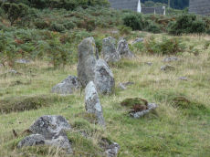
Wotter Common Reported Stone Circle
OS Map: SX 55872 62014
HER: MDV130502
ShortName: SC:Wotter Cmn
Notes: Possible stone circle at Wotter reported by Sam Goodwin on a Facebook posting. Facebook: Wotter Common Stone Circle
The remains in this area are chaotic and disturbed by later interference. It is hard to make out the original stones of the nearby stone rows.
The satellite imagery does seem to bear out a circle of stones. The linked HER record refers to a diagram found in Butler Volume 3 p. 107 (diagram) that refers to an east to west "alignment?" of around 8 stones. This would appear to be the top half of what appears to be this reported stone circle. So, Butler thought there was a possible stone row here.
The southern part of the stone circle includes a gate which may have been stones imported at a later date.
In 1998 there was a report by Fletcher, M. + Probert, S., 1998, "Shaugh Moor, Devon: An Archaeological Survey".
It states: "Other large upright stones occur near the east row. Two substantial uprights used as gateposts may have been moved from elsewhere and there are two uprights nearby which Butler suggests may be the remains of a row which lies at 90 degrees to the east row. Surveyed at 1:200."
So, this looks like a stone circle. Butler and others thought the northern section could be a section of stone row.
This site is an enigma that is difficult to interpret.
Nearby sites: SX 55872 62014
Distance: 1.93km