
Prehistoric sites within 5km of SX 74399 66178
Guidance for walkers: The monuments featured in this database are archaeological treasures and need to be protected and preserved - please do not disturb any sites. Please check access and firing times before visiting sites, not all sites listed are on open access land. Firing ranges and boundaries of open access areas are marked on the OL28 OS Dartmoor Explorer map. Please stick to the country code and consider giving support to the numerous agencies that help to keep Dartmoor a fabulous natural and historic environment!
About the database listings: In all listings clicking on the photo or the site name will open a page for the site with a larger photo and further details from the database. The database now has over 6680 records covering nearly all publicly listed sites on Dartmoor including around 4800 round houses. This level of detail is of interest to archaeologists but tends to swamp listings of sites more likely to be of interest for walkers. For this reason, the listings default to around 550 core sites only. These are the stone circles, stone rows and the ring cairns listed by Turner. The default search radius is 2 km. The controls below the map can be used to start a new search by entering a 6- or 8-digit reference (without the prefix "SX"). The search radius can be specified and you can add incremental Display layers of detail on top of the core sites. If using a more detailed layer you will need to decrease the search radius to avoid getting hundreds of search results.
- Core sites Default listing of core sites consisting of stone circles & rows and some of the major ring cairns.
- Plus cairns adds approx. 1000 cairns and other minor sites not included in the core listings but excluding round houses.
- Plus round houses adds approx. 4800 round houses.
- Plus non-sites adds in the records for sites that no longer exist or are not prehistoric sites.
- Plus duplicates adds records excluded as duplicates. Those maybe duplicate records in external listings (e.g. the Historic Environment Records). For example, some sites have been identified as cairns in some listings and interpreted as round houses in other listings and both records appear.
These listings have incorporated, matched up and merged all of the records from all of the major archaeological listings including: Worth, Grinsell, Turner, Butler, Bill Radcliffe, Sandy Gerrard, Megalithic Portal, the National Monument Records and the Historic Environment Records. The author would like to thank Bill, Sandy, the lovely people both at Megalithic Portal (especially Anne Tate who did an amazing job to link listings) and at ACE Archaeology for collaborative work over the years to synchronise and correct listings across the various websites which now interlink. A culmination of years of work the final merger of cairn records took 3 months of cross referencing in 2017 the result being a snapshot of the records at that time. This data has in turn been refined since by field work and research. The round house data was supplied by Sandy Gerrard. Grid references are in order of accuracy: from Google Earth satellite, if visible and found, from a Garmin GPS reading, if visited by the author and from the literature otherwise. Individual site pages will state the source of the grid reference and provide satellite imagery. If a site listing lacks a photo it has not yet been visited by the author in which case the grid reference is from the literature.
Currently the database only includes sites which can be represented by a grid reference. Reaves are not included as they require GIS shape technology which is beyond the current capability of this system. To see the sources for the records, look at the tables on the resources menu. The database listings can also be viewed on a Google map and downloaded as GPS datasets for Garmin devices.
Corrections, or any feedback or suggestions are very welcome, email: info@dartmoorwalks.org.uk.
NOTE: Clicking on the icons for each monument in the map will give the name of the site. You can zoom in and out and drag the map around.
List of sites within 5km of SX 74399 66178
Skerraton Ridge 2 Cairn
OS Map: SX 6998 6531
HER: MDV130243
ShortName: CN:SkerRidge 2
Butler map: 57.34.2
Butler Vol 5: p.17 & Fig.1
Grinsell: DEA 5a
Turner: A29
Notes: The following are thought to be the same: Grinsell DEA 5a SX69996530 (6 x 0.15) and Turner A29 70066529. It would seem both the the NMR and HER have treated these as two separate cairns - this can be seen from the grid referencs in the two NMR records and both HER records refer to Turner A29. NMR 444856 is thus a duplicate of 441549. HER 48850 is thus a duplicate of of HER 7833.
Nearby sites: SX 6998 6531
Distance: 4.50km
Skerraton Gate E.1 Cairn
OS Map: SX 70211 64979
HER: MDV7949
ShortName: CN:SkerrGate 1
Butler map: 57.34
Butler Vol 5: p.17 & Fig.1
Grinsell: DEA 13e
Notes: 444974/1572758/1572754
Nearby sites: SX 70211 64979
Distance: 4.36km
Skerraton Gate E.6 Cairn
OS Map: SX 70226 64917
HER: MDV7950
ShortName: CN:SkerrGate 6
Butler map: 57.34
Butler Vol 5: p.17 & Fig.1
Grinsell: DEA 13f
Notes: This entry was formerly for Skerraton Gate E.2 but another HER record now relates to that. The two grid references are just 20-30 metres apart and that woudl in most circumstances result in this being a case of duplication. However, Fig 1 on p.17 of Butlre Volume 5 cleary has two cairns very close together in this location. It maybe a happy accident that there are two records. The western of the two features (this one) is the larger and as such is probably the one Butler intended as E.2. See also Skerraton Gate E.2
Nearby sites: SX 70226 64917
Distance: 4.36km
Skerraton Gate E.3 Cairn
OS Map: SX 70269 64948
HER: MDV7946
ShortName: CN:SkerrGate 3
Butler map: 57.34
Butler Vol 5: p.17 & Fig.1
Grinsell: DEA 13g
Nearby sites: SX 70269 64948
Distance: 4.31km
Skerraton Gate E.4 Cairn
OS Map: SX 70270 65017
HER: MDV7829
ShortName: CN:SkerrGate 4
Butler map: 57.34
Butler Vol 5: p.17 & Fig.1
Grinsell: DEA 13h
Nearby sites: SX 70270 65017
Distance: 4.29km
Skerraton Gate S.W.1 Cairn
OS Map: SX 70008 64886
HER: MDV28587
ShortName: CN:SkerGateSW1
Butler map: 57.34
Grinsell: DEA 7
Nearby sites: SX 70008 64886
Distance: 4.58km
Skerraton Ridge 2 (duplicate 1) Cairn
OS Map: SX 6998 6531
HER: MDV7833
ShortName: CN:SkRgeDup1
Butler map: 57.34.2
Butler Vol 5: p.17 & Fig.1
Grinsell: DEA 5a
Turner: A29
Notes: The following are thought to be the same: Grinsell DEA 5a SX69996530 (6 x 0.15) and Turner A29 70066529. It would seem both the the NMR and HER have treated these as two separate cairns - this can be seen from the grid referencs in the two NMR records and both HER records refer to Turner A29. NMR 444856 is thus a duplicate of 441549. HER 48850 is thus a duplicate of of HER 7833.
Nearby sites: SX 6998 6531
Distance: 4.50km
Harbourne Head, NE of Cairn
OS Map: SX 69767 65582
HER: MDV5298
ShortName: CN:Harbourne 2
Grinsell: DEA 12
Notes: A cairn sited on hill slope on arable land crowned by a stoneheap.
Nearby sites: SX 69767 65582
Distance: 4.67km
Harbourneford 2 Cairn
OS Map: SX 7142 6224
HER: MDV13640
ShortName: CN:Harbourne2
Grinsell: BRE 12
Notes: Round barrow in arable field
Nearby sites: SX 7142 6224
Distance: 4.94km
Tynacombe 3 Cairn
OS Map: SX 704 634
HER: MDV13637
ShortName: CN:Tynacombe3
Notes: HER: A low grass-covered mound in the north-west corner of a field, which measures around 0.5 metres in height and 10 metres in diameter, with no stones visible. The edge is most clearly defined on the downhill side tending to merge into the natural hillside on the upper side.
Nearby sites: SX 704 634
Distance: 4.87km
Lambs Down 4 Clearance Cairn
OS Map: SX 69512 65809
HER: MDV13199
ShortName: CN:LambsDown 4
Nearby sites: SX 69512 65809
Distance: 4.90km
Lambs Down 1 Clearance Cairn
OS Map: SX 6973 6607
HER: MDV130234
ShortName: CN?LambsDown 1
Butler map: 57.33.1
Notes: Butler refers to burial cairns amongst clearance cairns.
Nearby sites: SX 6973 6607
Distance: 4.67km
Skerraton Gate E.2 Cairn
OS Map: SX 7024 6493
HER: MDV7947
ShortName: CN:SkerrGate 2
Butler map: 57.34
Butler Vol 5: p.17 & Fig.1
Notes: The HER record for E.2 was added close to an existing HEr record. The two grid references are just 20-30 metres apart and that would in most circumstances result in this being a case of duplication. However, Fig 1 on p.17 of Butlre Volume 5 cleary has two cairns very close together in this location. It maybe a happy accident that there are two records. The western of the two features (this one) is the larger and as such is probably the one Butler intended as E.2. This record realtes to the smaller eastern cairn. See also [https://www.dartmoorwalks.org.uk/resource/site.php?SiteID=1799]Skerraton Gate E.6[/url]
Nearby sites: SX 7024 6493
Distance: 4.34km
Lambs Down 2 Clearance Cairn
OS Map: SX 69452 65895
HER: MDV5196
ShortName: CN:LambsDown 2
Butler map: 57.33.2
Notes: Butler refers to burial cairns amongst clearance cairns.
Nearby sites: SX 69452 65895
Distance: 4.96km
Lambs Down 3 Clearance Cairn
OS Map: SX 6946 6585
HER: MDV130235
ShortName: CN:LambsDown 3
Butler map: 57.33.3
Notes: Butler refers to burial cairns amongst clearance cairns.
Nearby sites: SX 6946 6585
Distance: 4.95km
Skerraton Down 3 Clearance Cairn
OS Map: SX 7010 6522
HER: MDV7830
ShortName: CN:Skerraton 3
Butler map: 57.34
Butler Vol 5: p.17 & Fig.1
Grinsell: DEA 13c
Turner: B4
Notes: 444974/1572758/1572754
Nearby sites: SX 7010 6522
Distance: 4.40km
Skerraton Down 4 Clearance Cairn
OS Map: SX 7012 6520
HER: MDV7828
ShortName: CN:Skerraton 4
Butler map: 57.34
Butler Vol 5: p.17 & Fig.1
Grinsell: DEA 13d
Notes: 444974/1572758/1572754
Nearby sites: SX 7012 6520
Distance: 4.39km
Skerraton Ridge 1 Reported Cairn
OS Map: SX 69936 65357
HER: MDV5297
ShortName: CN:SkerRidge 1
Butler map: 57.34.1
Butler Vol 5: p.17 & Fig.1
Grinsell: DEA 11
Notes: 444974/1572758/1572754
Nearby sites: SX 69936 65357
Distance: 4.54km
Skerraton Ridge 3 Reported Cairn
OS Map: SX 700 653
HER: MDV130244
ShortName: CN?SkerRidge 3
Butler map: 57.34.3
Butler Vol 5: p.17 & Fig.1
Grinsell: DEA 5
Notes: "A circular mound about 7 metres in diameter and approximately 1 metre high. Turf covered, possibly undisturbed. Recorded in 1980s as destroyed by agricultural operations."
Nearby sites: SX 700 653
Distance: 4.49km
Skerraton Down 1 Reported Cairn
OS Map: SX 7007 6526
HER: MDV7832
ShortName: CN?Skerraton 1
Butler map: 57.34
Butler Vol 5: p.17 & Fig.1
Grinsell: DEA 13a
Notes: "A circular mound about 5 metres in diameter and approximetly 1 metre high. Turf-covered and apparently undisturbed (4 metres from field boundary). Recorded in 1980s as reduced to ground level by agricultural operations." 444974/1572758/1572754
Nearby sites: SX 7007 6526
Distance: 4.43km
Skerraton Down 2 Reported Cairn
OS Map: SX 7007 6524
HER: MDV7831
ShortName: CN?Skerraton 2
Butler map: 57.34
Butler Vol 5: p.17 & Fig.1
Grinsell: DEA 13b
Notes: "A circular mound about 12 metres in diameter. Composed of small stones and hollow in the centre (12 metres from the field boundary). Barrow recorded in 1980s as reduced to ground level by agricultural operations." 444974/1572758/1572754
Nearby sites: SX 7007 6524
Distance: 4.43km
Harbourneford 1 Reported Cairn
OS Map: SX 7137 6235
HER: MDV13641
ShortName: CN:Harbourne1
Grinsell: BRE 11
Notes: The site of a round barrow which has been under the plough for some years. A large number of worked flints have been found on the site.
Nearby sites: SX 7137 6235
Distance: 4.88km
Harbourneford 3 Reported Cairn
OS Map: SX 7145 6247
HER: MDV13641
ShortName: CN:Harbourne3
Grinsell: BRE 13
Notes: A round barrow situated in the south west corner of a grass field; the hedge turns to take account of it.
Nearby sites: SX 7145 6247
Distance: 4.74km
Skerraton Gate S.W.2 Reported Cairn
OS Map: SX 7006 6470
HER: MDV7944
ShortName: CN?SkerGateSW2
Grinsell: DEA 14
Notes: Cairn or clearance heap. formerly listed as Skerraton Down (DEA 14).
Nearby sites: SX 7006 6470
Distance: 4.58km
Lambs Down 6 Cairnfield Master
OS Map: SX 6985 6565
HER: MDV5299
ShortName: CN?LambsDown 6
Notes: HER: "A series of mounds which may be the result of modern field clearance, or they possibly be the remains of prehistoric cairns. Four of the larger mounds may have entrances and average 8.7 metres in diameter and 0.6 metres in height."
Nearby sites: SX 6985 6565
Distance: 4.58km
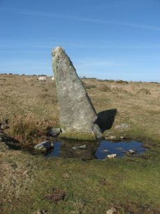
Harbourne Head Standing Stone
OS Map: SX 69676 65105
HER: MDV5197
Megalithic Portal: 42626
PMD: Harbourne Man Standing Stone
Alternate name: Harbourne Man Standing Stone
ShortName: SS Harbourne
Butler Vol 5: p.19
DPD page: 88
Notes: A standing stone represented by a leaning slab of moorland granite. It stands in a slight depression probably worn by cattle using it as a rubbing post. It is 2.40m in length and 1.0m by 0.3m at its base tapering to 0.3m by 0.15m. See also, Legendary Dartmoor: Dartmoor's Harbourne Man
Nearby sites: SX 69676 65105
Distance: 4.84km
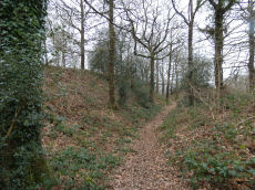
Hembury Castle (Buckfast) Fort
Prehistoric Dartmoor Walks: Dartmoor Resource: Table of Devon Iron Age Forts
OS Map: SX 72608 68455
HER: MDV7776
Megalithic Portal: 34692
Alternate name: Hembury Castle Fort
ShortName: FT HembCastle
Notes: "A hill fort with medieval castle within. Hill fort in Hembury woods, south east of Holne. A camp situated on the summit with a good view to the south and east."
Nearby sites: SX 72608 68455
Distance: 2.90km
Tynacombe Stone Ring Cairn Circle
OS Map: SX 7037 6328
HER: MDV13638
Megalithic Portal: 45832
ShortName: RC:Tynacombe
Turner: A20
Notes: "Ring cairn. Thynacombe stone ring 7.5 meters in diameter internally, with bank 1.5 meters wide and 0.2 meters high, damaged on the east side."
Nearby sites: SX 7037 6328
Distance: 4.96km