
Guide to the Monuments on Tottiford, Bridford and Christow

Table of Ritual and Burial Monuments on Tottiford, Bridford and Christow
Table of Round Houses on Tottiford, Bridford and Christow
| Guide # | Butler | SiteID | Site Name | OSX | Lat | Lon | NMR | HER | Barrow Report | Photo |
|---|---|---|---|---|---|---|---|---|---|---|
| 5246 | Bowden Beer Round House | SX8235084760 | 50.65053940 | -3.66560006 | n/a | MDV9340 | N | |||
| 5528 | Christow Common Round House | SX8228185410 | 50.65636826 | -3.66677999 | n/a | MDV9479 | N | |||
| 5529 | Christow Common Round House | SX8228085450 | 50.65673065 | -3.66681004 | n/a | MDV9475 | N | |||
| 5530 | Christow Common Round House | SX8227885483 | 50.65702820 | -3.66685009 | n/a | MDV13800 | N | |||
| 6427 | Hedgemoor Round House | SX8070085800 | 50.65956116 | -3.68926001 | n/a | MDV9511 | N | |||
| 6491 | Higher Lowton Down Round House | SX8132087100 | 50.67137146 | -3.68091011 | n/a | MDV26779 | N | |||
| 6737 | Inn Down Round House | SX8257284317 | 50.64659882 | -3.66231990 | n/a | MDV19918 | N | |||
| 6812 | Kiln Down Round House | SX8244084100 | 50.64463043 | -3.66411996 | n/a | MDV26506 | N | |||
| 8457 | Shippen Farm Round House | SX8289086970 | 50.67052078 | -3.65865993 | n/a | MDV26771 | N |
Tottiford, Bridford and Christow Guide Map
Guidance for walkers: The monuments featured in this database are archaeological treasures and need to be protected and preserved - please do not disturb any sites. Please check access and firing times before visiting sites, not all sites listed are on open access land. Firing ranges and boundaries of open access areas are marked on the OL28 OS Dartmoor Explorer map. Please stick to the country code and consider giving support to the numerous agencies that help to keep Dartmoor a fabulous natural and historic environment!
List of Ritual and Burial Monuments on Tottiford, Bridford and Christow
Moor Barton (site of) Reported Cist
OS Map: SX 78500 84300
NMR record: SX 78 SE 17
HER record: MDV5589
PMD: Moor Barton
ShortName: CT:Moor Bart1
Grinsell: MOR 6
Barrow Report: 60
Notes: There is an entrenched work at morebarton (in moreton), where a large barrow was opened circa 1840. Contained a cist of 6 great stones, a spearhead of copper, two rivets, a glass bead and a small stone amulet
Nearby sites: SX78508430
Heltor Rock (site of) Reported Cist
OS Map: SX 79960 87030
NMR: No record found
HER record: MDV8312
PMD: Hel Tor Rock
ShortName: CT?Heltor Ro1
Notes: Cist at heltor rock. Cist not located during field work and no further information obtained
Nearby sites: SX79968703
Tottiford Stone Circle
OS Map: SX 81095 83161
NMR: No record found
HER record: MDV102539
Megalithic Portal: 24205
PMD: Tottiford Reservoir
ShortName: SC Tottiford
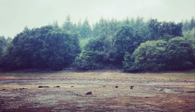
Notes: The Tottiford circle was discovered in 2009 when there was lower than usual levels of water in Tottiford reservoir; it featured as part of a Time Team dig in 2010. Normally it is submerged within the reservoir. During the drought of August 2022 the stones were exposed again for the first time for years. Photo by Zoe Lester taken on 04/09/22. Reproduced with kind permission - copyright remains with Zoe.
Nearby sites: SX81108316
Tottiford Reservoir 1 Stone Row
OS Map: SX 81137 83093
NMR: No record found
HER record: MDV102540
Megalithic Portal: 24205
The Stone Rows of GB: Tottiford Reservoir 1
PMD: Tottiford Reservoir Stone Rows
ShortName: SR Tottiford1
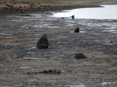
Notes: "This stone row was initially noticed in late 2009, when the reservoir was only 6% full. This double stone row is aligned roughly north-west - south-east and is at least 54 meters in length. The size and form of the stones used varies considerably but the two rows are consistently 1.2 meters apart. The row leads directly to (or away from) the naturally occurring mound south-east of the stone circle." This row will be normally covered by the Tottiford Reservoir. The stones of the row were exposed for a short period following the drought of August 2022. From the northenern end the author took a photo at SX 81135 83102 (6/9/22). It was too muddy to get any closer and the grid reference of SX 81137 83093 is inferred and used for this entry. Max Piper visited the day before and got as close as SX 81129 83102 which is consistent with the inferred actual location.
Nearby sites: SX81148309
Tottiford Reservoir 2 Stone Row
OS Map: SX 81104 83202
NMR: No record found
HER record: MDV102542
The Stone Rows of GB: Tottiford Reservoir 2
PMD: Tottiford Reservoir
Alternate name: Tottiford Reservoir II Stone Row
ShortName: SR Tottiford2
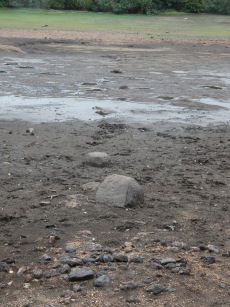
Notes: Excavated during the Time Team dig in 2011. This row will be normally covered by the Tottiford Reservoir. The stones of the row were exposed for a short period following the drought of August 2022. See Wessex Archaeology report Tottiford Reservoir: Archaeological Evaluation and Assessment of Results. See also Legendary Dartmoor - Time Team at Tottiford. The NGR used here is the eastern end from Max Piper (visit 05/09/22). Max recorded SX 81104 83202 for eastern end and SX 81077 83202 for western end. The author vistied on 06/09/22 and obtained SX 81117 83210 for the eastern end. The listing uses Max's NGR.
Nearby sites: SX81108320
Tottiford Reservoir Mound Cairn
OS Map: SX 81121 83132
NMR: No record found
HER record: MDV102544
ShortName: CN Tottiford
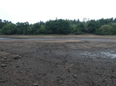
Notes: "A total of 156 pieces of worked flint were recovered from the excavation, with the majority of the material found consisting of debitage from flint working, most of which is small enough to qualify as chips. The small size of much of the material, the indications of blade and bladelet technology and one triangular platform rejuvenation flake, suggest a date in the (probably later) Meolithic for most of the material."
"A number of tools were recovered, including a neat end scraper of probable late Neolithic date, a notched flake of probable Meolithic date, an unstratified piercer and a crude end scraper from an unstratified location."
"The 2010 excavation of test pits on the mound confirmed the presence of worked flint and concluded the mound was a natural feature and also suggested that the presence of the flint could be the result of selective deposition by water originating upstream."
Nearby sites: SX81128313
Bridford 1 Crop Mark
OS Map: SX 81600 87350
NMR: No record found
HER record: MDV26759
ShortName: CNxBridford 1
Notes: From aerial photos
Nearby sites: SX81608735
Bridford 2 Crop Mark
OS Map: SX 83000 85810
NMR: No record found
HER record: MDV26761
ShortName: CNxBridford 2
Notes: From aerial photos
Nearby sites: SX83008581
Bridford 3 Crop Mark
OS Map: SX 82840 85730
NMR: No record found
HER record: MDV26772
ShortName: CNxBridford 3
Notes: From aerial photos
Nearby sites: SX82848573
Bridford 4 Crop Mark
OS Map: SX 82700 85550
NMR: No record found
HER record: MDV26773
ShortName: CNxBridford 4
Notes: From aerial photos
Nearby sites: SX82708555
Bridford 5 Crop Mark
OS Map: SX 80661 86990
NMR: No record found
HER record: MDV26778
ShortName: CNxBridford 5
Notes: From aerial photos
Nearby sites: SX80668699
Bridford 6 Crop Mark
OS Map: SX 82300 85400
NMR: No record found
HER record: MDV29044
ShortName: CNxBridford 6
Notes: From aerial photos
Nearby sites: SX82308540
Bridford 7 Reported Cairn
OS Map: SX 81340 87400
NMR record: SX 88 NW 5
HER record: MDV9476
ShortName: CN?Bridford 7
Nearby sites: SX81348740
Bridford 8 Reported Cairn
OS Map: SX 81250 86693
NMR record: SX 88 NW 6
HER record: MDV9505
ShortName: CN?Bridford 8
Nearby sites: SX81258669
Bridford 9 Reported Cairn
OS Map: SX 83000 85600
NMR: No record found
HER record: MDV9522
ShortName: CN?Bridford 9
Notes: About 1km from the barrow at barne on the right-hand side of the bridford-christow road, a granite bowl was discovered under a heap of stones. Neatly finished round rim, more worn on one side of the bottom than the other. It exhibited the effects of fire.
Nearby sites: SX83008560
Bridford (Site of) 10 Reported Cist
OS Map: SX 81965 86398
NMR record: SX 88 NW 4
HER record: MDV9509
PMD: Bridford
ShortName: CT?Bridford 10
Barrow Report: 60
Notes: A mid-19th century account recorded a possible cairn and cist at this approximate location. So far, any attempts to locate this feature have failed, but Bridford has been noted to have once contained numerous cairns and barrows.
Nearby sites: SX81978640
Barne Christow Reported Cist
OS Map: SX 83100 85100
NMR record: SX 88 NW 18
HER record: MDV9501
PMD: Barne, Christow
ShortName: CT:Barne 1
Barrow Report: 60
Notes: On Thomas Hamlyn's Estate at Barn, near Christow, a barrow containing a cist was destroyed during agricultered operations, etc., The cist contained a quantity of ashes, some burnt earth and 4 or 5 celts. 3 of these celts were built into a dry wall with the stones; the remaining two were kept, one by Hamlyn, one by Carrington.
Nearby sites: SX83108510
Christow Reported Cist
OS Map: SX 83400 84000
NMR record: SX 88 SW 27
HER record: MDV-1
PMD: Christow
ShortName: CT?Christow1
Notes: A stone cist of 4 wall slabs with an oval retaining ring of upright slab, was reported in the vicinity of Aller Farm, SX834840, in 1861.
Nearby sites: SX83408400
Page last updated 28/05/23