
Guide to the Monuments on Crane Hill
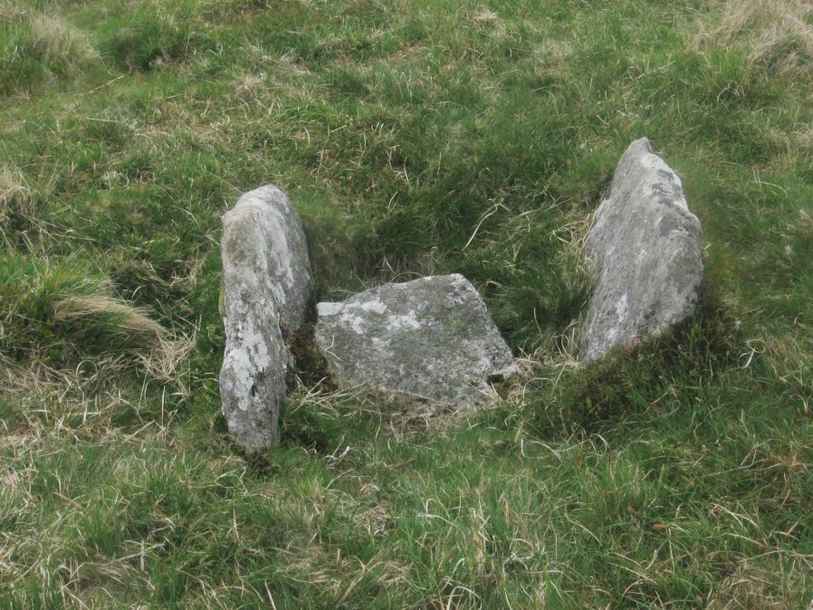
Table of Ritual and Burial Monuments on Crane Hill
The following table lists the records currently in this Guide Map. For an explantion of the Guide Maps and a table of all 62 Guide Maps, follow this link: Guide List Table. Introductory text will be added to each guide list in 2025. Notes on duplication and omissions will appear below the table once checks have been finalised.
Crane Hill Guide Map
Guidance for walkers: The monuments featured in this database are archaeological treasures and need to be protected and preserved - please do not disturb any sites. Please check access and firing times before visiting sites, not all sites listed are on open access land. Firing ranges and boundaries of open access areas are marked on the OL28 OS Dartmoor Explorer map. Please stick to the country code and consider giving support to the numerous agencies that help to keep Dartmoor a fabulous natural and historic environment!
List of Ritual and Burial Monuments on Crane Hill
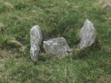
Great Gnat's Head Cist
OS Map: SX 61174 68034
HER record: MDV5091
Megalithic Portal: 45675
PMD: Great Gnat's Head
Alternate name: Great Gnats Head 1 Cist
ShortName: CT GreatGnats1
Butler map: 50.5.1
DPD page: 42
Grinsell: SHA 1
Barrow Report: 20
Notes: "Cist measures a maximum 1.0m long by 0.70m internally and 0.7m deep. Two side slabs and a fallen end slab are extant. There is no trace of a cover stone.". Lethbridge (near Abbot's Way cist) photo and diagram p.42 Butler Great Gnat's Head 1 - Vol. 3. Map 50.5 (diagram p.155).
Nearby sites: SX61176803
Great Gnats Head 2 Reported Cist
OS Map: SX 61190 68030
HER record: MDV5092
ShortName: CN:GreatGnats2
Butler map: 50.5.2
Grinsell: SHA 1a
Barrow Report: 20
Notes: "Round cairn adjacent to cist. Cairn lies 4m s of the cist and survives as a 4m diam and 0.2m high mound. This cairn was investigated in 1901 and found to cover a circular, carefully paved area lying on top of a large flat stone."
Nearby sites: SX61196803
Great Gnats Head 3 Cairn
OS Map: SX 61280 68050
HER record: MDV57383
ShortName: CN:GreatGnats3
Butler map: 50.5.3
Notes: HER entry does not match the size of the cairn listed by Butler.
Nearby sites: SX61286805
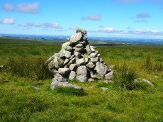
Great Gnats Head Cairn
OS Map: SX 61657 67908
HER record: MDV13177
Megalithic Portal: 45861
Alternate name: Great Gnats Head Summit 4 Cairn
ShortName: CN GreatGnats4
Butler map: 50.5.4
Grinsell: SHA 2
Notes: "A Bronze Age summit cairn, now badly disturbed by a conical walkers cairn built in the SW quadrant. It measures 8.5m in diameter, the outer slope is 0.3m high and the interior is scooped to a depth of 0.3m -small boulders and upright slabs are visible. The conical cairn is 2.6m in diameter and 1.5m high." Butler Volume 3 Map 50.5.
Nearby sites: SX61666791
Great Gnats Head 5 Cairn
OS Map: SX 61580 68029
HER record: MDV13176
ShortName: CN:GreatGnats5
Notes: HER: quoting Robinson Visited in September 1979. About 150 metres north-north-west of Grinsell's Shaugh Prior No.2. A cairn lying in area of blanket bog. Heather covered, hollows in centre and on east side. Diameter 10 metres, height 0.5 metres. also There are many peat stacks in the area which make reidentification of the cairn difficult.
The NGR for this record is estimated based on the decription.
Nearby sites: SX61586803
Great Gnats Head 6 Reported Cairn
OS Map: SX 61544 68085
HER record: MDV13178
ShortName: CN:GreatGnats6
Notes: HER: About 220 metres north-north-west of Grinsell's Shaugh Prior No.2, a low poorly defined heather covered cairn. Diameter circa 10 metres, height 0.5 metres.. There are many peat stacks in the area which make reidentification of the cairn difficult.
The NGR is estimated from the description. Could be a duplicate of HER 13176
Nearby sites: SX61546809
Great Gnats Head 7 Reported Cairn
OS Map: SX 61500 68100
HER record: MDV107559
ShortName: CN:GreatGnats7
Notes: HER: Site of a number of peat charcoal burning platforms on Great Gnats' Head. These are not cairns but included here to help explain the many mounds.
Nearby sites: SX61506810
Caters Beam Reported Cairn
OS Map: SX 63700 68800
HER record: MDV19966
ShortName: CN?Caters Beam
Grinsell: LYD 101a
Notes: A cairn was alleged on the north of Green Hill but there is no field evidence to substantiate this
Nearby sites: SX63706880
Crane Hill Reported Cairn
OS Map: SX 61882 68773
HER record: MDV78136
ShortName: CN:Crane Hill
Notes: HER: Greeves (2009) describes this a probable prehistoric cairn on Crane Hill, Dartmoor Forest. More recent investigation in 2024 has suggested it is in fact a meiler, or the site of a peat-charcoal kiln.
Nearby sites: SX61886877
Plym Head Reported Cist
OS Map: SX 61770 68390
HER record: MDV5093
PMD: Plym Head
ShortName: CNxPlym Head
Notes: A cairn was alleged at this location could no trace of it could be revealed during field investigation. NMR: Capstone 5 feet 8 inches by 5 feet 14 stones. Prostrate stones in circle, one over 8 feet high, one over 6 feet high, one over 3 feet high. Oriented 22 1/2o east of north. This is a little doubtful, the tinners might have made it.
HER: No cist could be found in this area in the vicinity of old streamworks. In the rough pasture there are numerous naturally disposed boulders and it seems likely that this is one of the Rev H Breton's flights of fancy. His activities as a correspondent for Crawford seem to have been from the First World War to about 1930.
Nearby sites: SX61776839
Plym Ford Reported Cist
OS Map: SX 61160 68510
HER record: MDV5094
PMD: Plym Ford
ShortName: CT?Plym Ford
Notes: Alledged cist - Breton. A cist was alleged at this location but could not be found on the ground
Nearby sites: SX61166851
Fox Tor Girt Reported Cairn
OS Map: SX 63204 69910
HER record: MDV103605
ShortName: CN?FoxTor Girt
Notes: A small cairn 130 metres east of Fox Tor Girt. It measures 2.6 metres in diameter and 0.6 metres high and is comprised of loose boulders roughly piled on large earthfast blocks.
Nearby sites: SX63206991
Foxtor Cross N.E. of Cairn
OS Map: SX 61930 69880
HER record: MDV5095
PMD: Fox Tor Mires S.
ShortName: CT?FoxtorCross
Notes: [Presumably Foxtor not Foxton] Cist 54.9 meters south east of white stone in the wall. Area was over grown with high heather in 1917-1918, but the heather was burnt in 1920 and the cist was quite plain with capstone by north east side. The south west stone had gone. No trace of this antiquity could be found in 1950.
Nearby sites: SX61936988
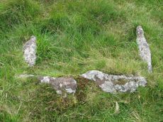
Goldsmith's Cross S. Cist
OS Map: SX 61684 69872
HER record: MDV5081
Megalithic Portal: 42708
PMD: Fox Tor Mires S 5
Alternate name: Goldsmiths Cross S. Cist
ShortName: CT Goldsmith S
Butler map: 64.5
DPD page: 97
Grinsell: LYD 100
Barrow Report: 46 56
Notes: "The remains of a cist lie some 80m E of the Whealam stream works at SX 61666985, on gently sloping ground 50m S of the newtake wall. The remains consist of four granite slabs set into the ground, forming three sides of a trapezoidal structure. It measures 1.2m long and a maximum of 0.85m wide. The long side, unusually formed of two granite slabs, is oriented NW to SE. The maximum height which the stones protrude above the ground is 0.2m. The SW side of the structure is missing; there are no traces of a capstone or cairn".
Nearby sites: SX61686987
Nuns Cross Farm (site of) Reported Cist
OS Map: SX 60600 69800
HER record: MDV5156
PMD: Nun's Cross Farm
ShortName: CT?Nuns Cross
Butler map: 64.6
Grinsell: LYD 108
Barrow Report: 14 16 21
Notes: Worth (1892): Within the past few years a kistvaen has been uncovered at Nuns Cross farm and totally destroyed. No relics were found. William Hooper told me that the cover stone of the kist had long been exposed on the surface of the field, and that one day when the necessity for just such a stone arose he took this up, and to his surprise uncovered the kistvaen.
Some effort seems to have been made to examine the spot and unearth any relics, but without success.
Nearby sites: SX60606980
Page last updated 10/12/24