
Guide to the Monuments on Princetown
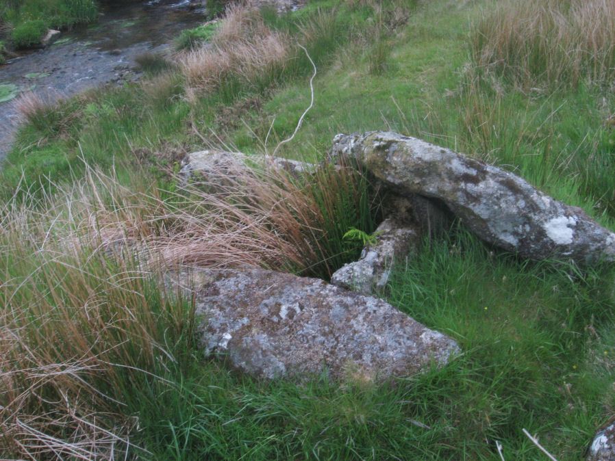
Table of Ritual and Burial Monuments on Princetown
The following table lists the records currently in this Guide Map. For an explantion of the Guide Maps and a table of all 62 Guide Maps, follow this link: Guide List Table. Introductory text will be added to each guide list in 2025. Notes on duplication and omissions will appear below the table once checks have been finalised.
Notes on possible duplications and omissions
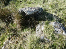
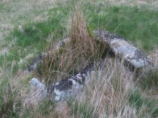
Littaford Tor E Cist: This feature was discovered by Tom Greeves. The record originates on Bill Radcliffe's Prehistoric Monuments of dartmoor website, quote: Long axis approx W-E . Stones visible on N, E and S sides and some stone could be felt under grass on W side. Approx. 1m x 0.5m x 0.5m depth internally. No obvious sign of cairn mound. No obvious stonecutting in vicinity. TAP Greeves (pers. comm.). The author (Dave Parks) took a photo on 20/07/2020 and recorded the location using a garmin device at SX 61846 76717, see: Littaford Tor E Cist. It looks like a plausible cist that should be listed on the HER.Crockern Tor 3 Reported Cist: Reported to the author by Bill Radlciffe on 09/02/25. Possible cist near path reported by Nigel Rendle to Bill in 2008. Candidate for inclusion in HER? Looks like a plausible cist in photo see by the author.
North Hessary Tor 3: This record is not on the HER but it relates to a feature that Grinsell listed as untraceable. Recommend that it is not added to the HER.
NB. Prowse entries from 1901, a reminder to the author: Prowse recorded very many sites in his 1901 article The Antiquities of Ockery and Roundhill (T.D.A. Vol.33 pp.495-499). In many respects an impressive early survey but arguably he did not have the skill/knowledge of a modern archaeologist and a few of these reported features are either natural or features such as pillow mounds mistaken for cairns. Grid references from 1901 are inaccurate so these records are a bit difficult to untangle. Quite a few of the records above originate from Prowse and may require a more detailed look at a later date.
PS. These notes are to assist untangling complicated records and are neither permanent nor a criticism of the HER who do a fantastic job! The author finds it easier to systematically work through these records (2000+ of them) and add these notes, which are then to be communicated with the HER, if appropriate, it is a pragmatic way of dealing with lots of data without continually stopping and starting.
Princetown Guide Map
Guidance for walkers: The monuments featured in this database are archaeological treasures and need to be protected and preserved - please do not disturb any sites. Please check access and firing times before visiting sites, not all sites listed are on open access land. Firing ranges and boundaries of open access areas are marked on the OL28 OS Dartmoor Explorer map. Please stick to the country code and consider giving support to the numerous agencies that help to keep Dartmoor a fabulous natural and historic environment!
List of Ritual and Burial Monuments on Princetown
Littaford Tor E Cist
OS Map: SX 61846 76717
HER: No record found
PMD: Littaford Tor E.
ShortName: CT Littaford 1
Notes: Radcliffe: "Long axis approx W-E . Stones visible on N ,E and S sides and some stone could be felt under grass on W side. Approx. 1m x 0.5m x 0.5m depth internally. No obvious sign of cairn mound. No obvious stonecutting in vicinity. TAP Greeves (pers. comm.) "
Nearby sites: SX61857672
Littaford Tor 2 Reported Cairn
OS Map: SX 61430 76490
HER record: MDV52778
ShortName: CN Littaford 2
Butler map: 29.1
Notes: A large granite slab lies the W side and a boulder is exposed just N of the centre. These may be part of a distroyed cist, but the boulder is very irregular and looks like a natural stone in situ around which the cairn may have been built.
Nearby sites: SX61437649
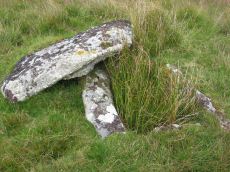
Crockern Tor Cist
OS Map: SX 61414 76055
HER record: MDV57569
Megalithic Portal: 45816
PMD: Crockern Tor
Alternate name: Crockern Tor 1 Cist
ShortName: CT CrockernNW1
Butler Vol 5: p.32 & Fig.11
DPD page: 110
Notes: "Remains of a small cairn with cist on a moderate W slope in open grassland at SX 61407604 overlooking the West Dart in Crockern Newtake. It has been robbed heavily, leaving only one cist slab and fragments of the cairn material. The slab is restangular in side view and in section, firmly embedded on edge, measuring 1.2m long 0.48m high and 0.15m thick. It is aligned NW to SE." Butler Vol 5 p. 32. Lethbridge diagram and photo p.110.
Nearby sites: SX61417606
Crockern Tor 2 Cairn
OS Map: SX 61262 75987
HER record: MDV52777
ShortName: CN CrockernNW2
Nearby sites: SX61267599
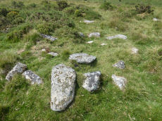
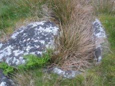
Crockern Tor 3 Reported Cist
OS Map: SX 61204 75824
HER: No record found
ShortName: CT CrockernNW3
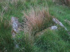
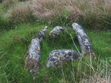
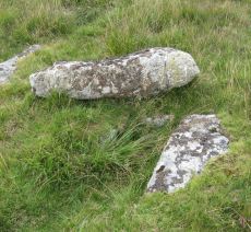
Notes: Possible cist reported by Nigel Rendle to Bill Radcliffe in 2008 NE of Crockern Farm. Bill comments Feb 2025 we were doubtful of it, as it is close to the path to Wistman's Wood, so how can it have been missed? But it looks good to me.. The author visited 25/09/2025 with Steve Szypko and these were my notes: there is an upright stone that looks like a possible displaced capstone and some other stones that could form a cist. This arrangement in itself is unconvincing but there is also a rectangular hole consistent with a cist. It is perhaps an unlikely but possible cist. NB. The grid reference has now been updated.
Nearby sites: SX61207582
Beardown Farm Cist
OS Map: SX 60400 75400
HER record: MDV5974
Megalithic Portal: 45789
PMD: Beardown Farm
ShortName: CTxBeardown Fm
Grinsell: LYD 46
Notes: The site is believed to have been destroyed many years ago Bray 1879 (included in listing as 130 in Grinsell list). Area is covered in Butler Vol 2 Map 29. "The remains of a cist surrounded by a rough pavement was examined by Mr Bray in September 1832 'two or three minutes walk north east of Beardown House' (at SX 604 754). Three stones of a four foot long cist stood six inches above ground level. A small piece of coarse pottery was found inside."
Nearby sites: SX60407540
Holmingbeam Cup Stone
OS Map: SX 59488 75233
HER record: MDV12807
Megalithic Portal: 10606
ShortName: CS Holmingbeam
DPD page: 107
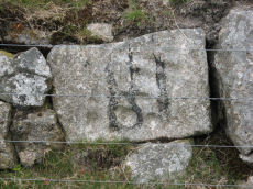
Notes: "Mortar stone of uncertain date incorporated into the eastern boundary wall of Long Plantation. It was formerly, erroneously, recorded as a cup-marked stone." The stone is upside down in wall by road side and has the figure 18 painted on it. Lethbridge diagram and photo p.107
Nearby sites: SX59497523
North Hessary Tor 1 Cairn
OS Map: SX 57877 74224
HER record: MDV5015
ShortName: CN:North Hes 1
Butler map: 44.9.1
Grinsell: WAL 8
Notes: HER: Possible round barrow on North Hessary Tor of 7.0 metrs diameter by 0.4 metres high which some authorities suggest may be a much later pillow mound or flagpole support
Nearby sites: SX57887422
North Hessary Tor 2 Reported Cairn
OS Map: SX 57780 74320
HER record: MDV131561
ShortName: CN?North Hes 2
Butler map: 44.9.2
Notes: Butler: A more likely xample of a burial cairn lies about 100m downhill [from the North Hessary Tor summit cairn] to the north, a very disurbed mound beside the road.
Nearby sites: SX57787432
North Hessary Tor 3 Reported Cist
OS Map: SX 57800 74200
HER: No record found
PMD: Hessary Tor
ShortName: CT?North Hes 3
Butler map: 44.9.3
Grinsell: B:WAL 36
Notes: Dilapidated cairn 'remarkable for beign double kisted' (Bate 1871). Grinsell doubtful site. Could be HER 5015, see also WAL 8. Butler suggests that Bate was possibly referring to the rather confused structure of the Yellowmead cist well down the western slopes (Butler Vol 3 p.33).
Nearby sites: SX57807420
Thornworthy 2 Cist
OS Map: SX 59015 73471
HER record: MDV6613
Megalithic Portal: 15453
PMD: Thornworthy
ShortName: CT Thornworth
Butler map: 35.22
Butler Vol 5: p.64 & Fig.42
DPD page: 137
Grinsell: CHA 3
Turner: E39
Barrow Report: 56
Notes: Located at the High Moorland Visitor Centre at Princetown. There were two cists at Thornworthy and both were excavated. This record refers to the second slightly smaller cist. This was removed after the excavation and given to the care of William Pengelly (see account 1880) of the Torquay Natural History Society and re-erected at Torquay Museum. The cist is now located in the Jack Wigmore Garden (also known as the Dartmoor Conservation Garden). It can be accessed by walking a very short distance down from the mini roundabout outside the centre down the Yelverton Road (Plymouth Hill). A gate on the right hand side behind the visitors centre gives access to the garden. See also: Thornworthy Cist. Butler Vol. 2. Map 35.22 p.169, see also diagram Vol. 5. p.64.
Nearby sites: SX59027347
Roundhill, Near Summit Cist
OS Map: SX 61046 74428
HER record: MDV6217
Megalithic Portal: 45682
PMD: Round Hill Summit W.
Alternate name: Round Hill Summit 1 Cist
ShortName: CT Roundhill 1
Butler map: 65.1.1
DPD page: 105
Grinsell: LYD 78
Barrow Report: 31 44
Notes: Butler Round Hill Summit 1 - Vol. 4. Map 65.1 (p.227-9, diagram of Round Hill cairns p.228). Lethbridge p.103 diagram Cist(A), photo top p.105.
Nearby sites: SX61057443
Roundhill, East of Summit Cist
OS Map: SX 61164 74413
HER record: MDV6257
Megalithic Portal: 45681
PMD: Round Hill E.
Alternate name: Round Hill Summit 2 Cist
ShortName: CT Roundhill 2
Butler map: 65.1.2
DPD page: 105
Grinsell: LYD 79
Barrow Report: 31 44
Notes: "A well preserved cist, situated on a slight east-facing slope just off the crest of a rounded hilltop. It stands in isolation on a generally stone-free area of rough moorland pasture. The side slabs are each 1.2m long and up to 0.3m thick and the end slabs are 0.55m long, 0.15m wide and 0.4m long, 0.1m wide respectively. The coverstone is up to 1.6m long, 0.9m wide and 0.2m thick. There are no surface indications of either a cairn or mound around the cist." Lethbridge p.103 diagram Cist(B), photo bottom p.105. Butler Round Hill Summit 2 (Cist 2) - Vol. 4. Map 65.1 (p.227-9, diagram of Round Hill cairns p.228).
Nearby sites: SX61167441
Round Hill Summit 3 Reported Cist
OS Map: SX 61110 74470
HER record: MDV6256
PMD: Round Hill NE.
ShortName: CT?Roundhill 3
Butler map: 65.1.3
Notes: Alledged cist and stone row asdescribed by Prowse 1901. No significant features can be identified in this area.
Nearby sites: SX61117447
Round Hill Summit 4 (site of) Reported Cist
OS Map: SX 61046 74422
HER record: MDV6238
PMD: Blackabrook (Possible Stone Row)
ShortName: CT?Roundhill 4
Notes: Duplicate of HER 6256? Cist noted (prowse). Vis=not visible on raf photos (rchm app 1985). Vis=2/9/1950 (os) no trace of this feature found.
Nearby sites: SX61057442
Round Hill S.1 Reported Cairn
OS Map: SX 60990 74150
HER record: MDV6372
ShortName: CN?Roundhill S
Butler map: 65.1.4
Grinsell: LYD 77
Nearby sites: SX60997415
Roundhill SW (N) Cist
OS Map: SX 60916 74160
HER record: MDV6248
Megalithic Portal: 45680
PMD: Roundhill SW 2
Alternate name: Round Hill S.2 Cist
ShortName: CT RoundhillS2
Butler map: 65.1.5
DPD page: 106
Grinsell: LYD 76
Barrow Report: 31
Notes: Northern of a pair of cists. Butler Round Hill S. 3. (Cairn 6) - Vol. 4. Map 65.1 (p.227-9 general plan of diagram of Round Hill cairns p.228). LYDFORD 75. "A turf-covered cairn, slightly spread on the northern side, measuring 5.0 meters by 4.8 meters and 0.5 meters in height. An almost centrally placed upright slab, 0.6 meters long and 0.13 meters wide and a large slab at the foot of the mound could both be part of a disturbed cist. There is no evidence of a kerb". Lethbridge diagram p.103, photo bottom p.106.
Nearby sites: SX60927416
Roundhill SW (S) Cist
OS Map: SX 60910 74140
HER record: MDV6249
Megalithic Portal: 52683
PMD: Roundhill SW 1
Alternate name: Round Hill S.3 Cist
ShortName: CT RoundhillS3
Butler map: 65.1.6
DPD page: 106
Grinsell: LYD 75
Barrow Report: 31 44
Notes: Southern of a pair of cists. "Small turf-covered cairn with an open cist in the centre. Diameter of cairn 4.0m. Height 0.5m. The cist is practically buried under the turf now. Internal dimensions 0.85m x 0.5m. The capstone is 1.1m x 0.8m rests on the north side of the cairn. Condition of cairn and cist - fairly good. Orientation of the long axis of the cist is WNW-ESE." Lethbridge diagram p.103, photo top p.106. Butler Round Hill S. 2. (Cairn 5) - Vol. 4. Map 65.1 (p.227-9 general plan of diagram of Round Hill cairns p.228).
Nearby sites: SX60917414
Round Hill E.1 Reported Cairn
OS Map: SX 61700 74200
HER record: MDV6240
ShortName: CNxRoundhillE1
Nearby sites: SX61707420
Round Hill E.2 Reported Cairn
OS Map: SX 61610 74410
HER record: MDV18229
ShortName: CN:RoundHillE2
Notes: HER quoting Quinnell: [i]The earthwork noted by Greeves (1982) is at SX 61607440 on a triangular patch of moorland, effectively isolated by a silted stream course on the W and S and tin workings to the E, with the West Dart to the N.
Nearby sites: SX61617441
Round Hill E.3 Reported Cairn
OS Map: SX 61230 74400
HER record: MDV6219
ShortName: CN?RoundHillE3
Grinsell: B:LYD 79a
Notes: Ditched mounds believed to be pillow mounds of rabbit warren c 18/19. See also duplicate HER record 54366.
Nearby sites: SX61237440
Round Hill E.4 Reported Cairn
OS Map: SX 61550 74210
HER record: MDV6239
ShortName: CN?RoundHillE4
Grinsell: B:LYD 79b
Notes: Ditched mounds believed to be pillow mounds of rabbit warren c 18/19
Nearby sites: SX61557421
Round Hill E.5 Reported Cairn
OS Map: SX 61710 74200
HER record: MDV6240
ShortName: CN?RoundHillE5
Grinsell: B:LYD 79c
Notes: Ditched mounds believed to be pillow mounds of rabbit warren c 18/19
Nearby sites: SX61717420
Round Hill E Reported Stone Row
OS Map: SX 61210 74390
HER record: MDV6220
PMD: Roundhill E.
ShortName: SR:RoundHill E
Notes: Record originates with Prowse. HER: Stone alignment east of Round Hill later identified as a prehistoric field boundary
Nearby sites: SX61217439
Oakery (c.6) Cairnfield Master
OS Map: SX 59700 74000
HER: No record found
ShortName: CNxOakery M
Butler map: 65.3
Notes: LYD 69-74. Clearance cairns? See individua listings -this record is a duplicate in that it refers to all of them.
Nearby sites: SX59707400
Oakery 1 Clearance Cairn
OS Map: SX 59754 74111
HER record: MDV3792
ShortName: CNxOakery 1
Grinsell: LYD 69
Notes: 6 post-medieval stone heaps
Nearby sites: SX59757411
Oakery 2 Clearance Cairn
OS Map: SX 59764 74105
HER record: MDV3793
ShortName: CNxOakery 2
Grinsell: LYD 70
Notes: 6 post-medieval stone heaps
Nearby sites: SX59767411
Oakery 3 Clearance Cairn
OS Map: SX 59767 74096
HER record: MDV3794
ShortName: CNxOakery 3
Grinsell: LYD 71
Notes: 6 post-medieval stone heaps
Nearby sites: SX59777410
Oakery 4 Clearance Cairn
OS Map: SX 59792 74070
HER record: MDV3795
ShortName: CNxOakery 4
Grinsell: LYD 72
Notes: 6 post-medieval stone heaps
Nearby sites: SX59797407
Oakery 5 Clearance Cairn
OS Map: SX 59797 74066
HER record: MDV3796
ShortName: CNxOakery 5
Grinsell: LYD 73
Notes: 6 post-medieval stone heaps
Nearby sites: SX59807407
Oakery 6 Clearance Cairn
OS Map: SX 59815 74055
HER record: MDV3797
ShortName: CNxOakery 6
Grinsell: LYD 74
Notes: 6 post-medieval stone heaps
Nearby sites: SX59827406

Blackabrook, South Cist
OS Map: SX 60524 73860
HER record: MDV6254
Megalithic Portal: 45679
PMD: Blackabrook
Alternate name: Round Hill S.E.1 Cist
ShortName: CT Blackbrk S
Butler map: 65.3.1
DPD page: 103
Grinsell: LYD 80
Barrow Report: 31 44
Notes: "This cist with its displaced capstone lies on the edge of the river bank. Vestiges of the small surrounding cairn are now hidden under the turf. The chamber of the cist measures 1.25m by 0.55m and about 0.5m deep; the capstone is 1.5m long, 1.1m wide and 0.15m thick. The south stone has fallen outwards." Lethbridge p.103 diagram Black Brook Cist(A), photo p.103. Butler Round Hill S.E. 2. - Vol. 4. Map 65.3 (diagram of cists alongside the Blackbrook pp.230-1).
Nearby sites: SX60527386
Blackabrook, West Cist
OS Map: SX 60522 73867
HER record: MDV6253
Megalithic Portal: 45679
PMD: Blackabrook NW.
Alternate name: Round Hill S.E.2 Cist
ShortName: CT Blackbrk W
Butler map: 65.3.2
DPD page: 104
Grinsell: LYD 81
Barrow Report: 31 44
Notes: "The reed-filled cist is approximately 1.0m by 0.7m and about 0.2m deep. Peat has accumulated around the sides of the slabs but a few stones evident on the SW side may be part of a robbed cairn." Lethbridge p.103 diagram Black Brook Cist(B), photo p.104. Butler Round Hill S.E. 1 - Vol. 4. Map 65.3 (diagram of cists alongside the Blackbrook pp.230-1). Plan by R.H. Worth of in Barrow Report 31 includes plan of Blackabrook cairn group.
Nearby sites: SX60527387
Blackabrook, East Cist
OS Map: SX 60528 73873
HER record: MDV6252
Megalithic Portal: 45679
PMD: Blackabrook E.
Alternate name: Round Hill S.E.3 Cist
ShortName: CT Blackbrk E
Butler map: 65.3.3
DPD page: 104
Grinsell: LYD 82
Barrow Report: 31 44
Notes: "A well defined cist which has two stones supporting the slabs in the SE corner. The chamber measures 0.95m by 0.85m and about 0.4m deep. A turf-covered stony spread around the cist may be part of a robbed cairn." Lethbridge p.103 diagram Black Brook Cist(C), photo bottom p.104. Butler Round Hill S.E. 3 - Vol. 4. Map 65.3 (diagram of cists alongside the Blackbrook pp.230-1).
Nearby sites: SX60537387
Round Hill S.E.4 Cairn Circle & Cist
OS Map: SX 60630 73960
HER record: MDV6250
PMD: Roundhill Leat
ShortName: CN:RoundhilSE4
Butler map: 65.3.4
Grinsell: LYD 83
Notes: Prowse 1901. Cairn with retaining circle. Remnant of a small cairn enclosing portions of two kists side by side, level with the surface and nearly filled up with soil. Note - cists no longer visible.
Nearby sites: SX60637396
Blackbrook 1 Reported Cairn
OS Map: SX 60230 73870
HER record: MDV6288
ShortName: CN:Blackbrk 1
Notes: In area of tin working.
Nearby sites: SX60237387
Blackbrook 2 Reported Cairn
OS Map: SX 60060 73920
HER record: MDV6289
ShortName: CNxBlackbrk 2
Grinsell: B:LYD 80a
Notes: Remains of a small tumulus (prowse). There is no evidence of a cairn in this area.
Nearby sites: SX60067392
Blackbrook (Prowse) Reported Cist
OS Map: SX 60500 73840
HER record: MDV6247
PMD: Blackabrook W.
ShortName: CT?Blackbrk 3
Notes: Prowse, A. B., 1901, The Antiquities of Ockery and Roundhill. An imperfect ring of stones five yards in diameter, which must at some time have encircled a kisvaen. Doubtful!
Nearby sites: SX60507384
Blakey Tor Cairn
OS Map: SX 61150 73730
HER record: MDV18419
PMD: Blakey Tor
ShortName: CN:Blakey Tor
Notes: Radcliffe, doubtful cist: Possibly the cairn referred to in an English Heritage Report and by Fletcher and Dunn in "Patterns of the Past", at SX 6115 7373, as a cairn having a "shallow depression in its top".
Nearby sites: SX61157373
Blakey Tor (E) Cist
OS Map: SX 61312 73558
HER record: MDV6245
Megalithic Portal: 28869
PMD: Blakey Tor E.
Alternate name: Blakey Tor E. Cist
ShortName: CT Blakey Tor
Butler map: 65.4
DPD page: 102
Grinsell: LYD 85
Barrow Report: 31 47
Notes: "A reed-filled cist is set well into the cairn on a NNW-SSE axis. The intact chamber measures internally 0.95m long, a maximum 0.65m wide and 0.45m deep; the longest side slab is 1.4m by 0.3m by 0.45m and largest end slab 0.55m by 0.2m by 0.4m. The coverstone against the NW side of the cist is roughly oval in shape and measures 1.7m by 1.3m and a maximum 0.25m thick." Lethbridge diagram p.102 Cist(B), photo p.102. Butler Vol. 4. Map 65.4 (diagram p.232).
Nearby sites: SX61317356
Blakey Tor (W) Cist
OS Map: SX 61240 73551
HER record: MDV6244
Megalithic Portal: 45772
PMD: Blakey Tor W.
Alternate name: Blakey Tor W. Cist
ShortName: CT BlakeyTor W
Butler map: 65.4
DPD page: 103
Grinsell: LYD 84
Notes: "The incomplete cist is oriented NW-SE. It measures about 0.85m long, 0.4m to 0.55m wide and 0.25m deep internally. The upright W side slab is 0.9m by 0.2m by 0.25m and the surviving end slab is 0.4m by 0.2m by 0.25m. The E side is formed by a flat-sided boulder which is c. 1.1m long, at least 0.6m thick and 0.25m high. The SE side is open. The coverstone is 1.7m by 0.7m by 0.4m and leans against the W side of the cist." Lethbridge diagram p.102 Cist(A), photo top p.103. Butler Blakey Tor W. - Vol. 4. Map 65.4 (diagram p.232).
Nearby sites: SX61247355
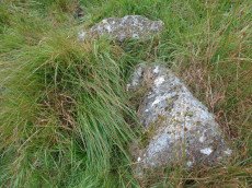
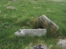
Bachelors Hall Reported Cist
OS Map: SX 60426 73665
HER record: MDV18392
PMD: Bull Park
ShortName: CT-Bachelors
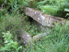
Notes: Greeves cairn and cist. Supposed cairn & cist poss natural feature. As can be seen in the photo this looks more like a natural feature.
Nearby sites: SX60437367
Page last updated 10/12/24