
Guide to the Monuments on North Brent Tor and Willsworthy
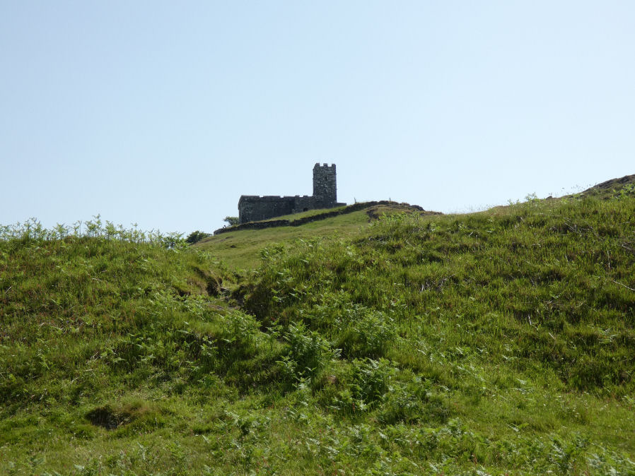
Table of Ritual and Burial Monuments on North Brent Tor and Willsworthy
The following table lists the records currently in this Guide Map. For an explantion of the Guide Maps and a table of all 62 Guide Maps, follow this link: Guide List Table. Introductory text will be added to each guide list in 2025. Notes on duplication and omissions will appear below the table once checks have been finalised.
Notes on possible duplications and omissions
Heathfield (Lamerton 1-10) There are 10 cairns listed by Grinsell as Lamerton 1 to 10. The first is in fact in the parish of milton Abbot and grinsell duplicates that one as Lamerton 1 to group them together. We keep both records here to give a full listing of all Grinsell records, but it is otherwise a trivial duplicate, that only appears here. There is also a master record both on the HER and on here which give an overview which is marked as a duplicate here but is a useful record to keep. One of these cairns is known to have been used as the historic site of a beacon but it is unknown whether it was Lamerton 6 or 7. The entries for these two cairns are duplicated with separate beacon entries. It probably makes sense to have one such duplicate as it is diffcult to know which cairn is the actual site of the beacon but the second duplicate seems unecessary.PS. These notes are to assist untangling complicated records and are neither permanent nor a criticism of the HER who do a fantastic job! The author finds it easier to systematically work through these records (2000+ of them) and add these notes, which are then to be communicated with the HER, if appropriate, it is a pragmatic way of dealing with lots of data without continually stopping and starting.
North Brent Tor and Willsworthy Guide Map
Guidance for walkers: The monuments featured in this database are archaeological treasures and need to be protected and preserved - please do not disturb any sites. Please check access and firing times before visiting sites, not all sites listed are on open access land. Firing ranges and boundaries of open access areas are marked on the OL28 OS Dartmoor Explorer map. Please stick to the country code and consider giving support to the numerous agencies that help to keep Dartmoor a fabulous natural and historic environment!
List of Ritual and Burial Monuments on North Brent Tor and Willsworthy
Brent Tor Fort
OS Map: SX 47100 80400
HER record: MDV1669
Megalithic Portal: 28169
ShortName: FT Brent Tor
Notes: HER: Iron Age hillfort at Brent Tor, with an incomplete rampart enclosing the north and eastern sides of the tor. The hill was subsequently used by the abbots of Tavistock as the site for Brentor parish church. Additional earthworks within the area enclosed by the rampart may represent the site of a medieval fair and post-medieval quarrying or mining.
Nearby sites: SX47108040
Brent Tor A Ancient Pool
OS Map: SX 46543 80335
HER record: MDV127195
ShortName: PO:Brent Tor A
Notes: Greeves: Brent Tor pool A measures around 40 by 30m. One of over 40 such 'sacred' pools identified on Dartmoor (or just outside the boundary of the National Park) that are thought to have potentially been designed during the prehistoric period
Nearby sites: SX46548034
Brent Tor B Ancient Pool
OS Map: SX 46610 80291
HER record: MDV127199
ShortName: PO:Brent Tor B
Notes: Greeves: Brent Tor pool B measures around 50 by 40m. One of over 40 such 'sacred' pools identified on Dartmoor (or just outside the boundary of the National Park) that are thought to have potentially been designed during the prehistoric period
Nearby sites: SX46618029
Brent Tor C Ancient Pool
OS Map: SX 46648 80267
HER record: MDV127200
ShortName: PO:Brent Tor C
Notes: Greeves: Brent Tor pool C measures around 40 by 35m. One of over 40 such 'sacred' pools identified on Dartmoor (or just outside the boundary of the National Park) that are thought to have potentially been designed during the prehistoric period
Nearby sites: SX46658027
Brent Tor D Ancient Pool
OS Map: SX 46679 80226
HER record: MDV127201
ShortName: PO:Brent Tor D
Notes: Greeves: Brent Tor pool D measures around 28 by 25m. One of over 40 such 'sacred' pools identified on Dartmoor (or just outside the boundary of the National Park) that are thought to have potentially been designed during the prehistoric period
Nearby sites: SX46688023

Gibbet Hill 1 Stone Ring Cairn Circle
OS Map: SX 49975 80875
HER record: MDV22751
Megalithic Portal: 45828
ShortName: RC GibbetHill1
Grinsell: MAR 1
Notes: "A stone ring, probably the remains of a ring cairn, 430 metres south-west of Gibbet Hill summit. This site is on the local list of Nationally Important Dartmoor sites. Dimensions noted by Greeves as approximately 22 metres in external diameter with the ring bank being a maximum of approximately 7.0 metres wide by approximately 0.5 metres in height."
Photo and annotated photo reproduced with kind permision by Steve Grigg. Copyright remains with Steve. See also coverage on Dartmoor Explorations: Gibbet Hill Mine.
Nearby sites: SX49988088

Gibbet Hill 2 Stone Ring Cairn Circle
OS Map: SX 50298 81148
HER record: MDV3202
ShortName: RC GibbetHill2
Notes: "A barrow was recorded somewhere near the summit of Gibbet Hill in 1891. Greeves recorded two ring cairns here in 1993 one of which is likely to be the same feature. This ring cairn lies around 20 metres west of the trig point. The cairn has a disturbed ring bank and measures about 18 metres in diameter."
This record was missing and added after correspondence from Steve Grigg on 22/11/2024. Photo and annotated photo reproduced with kind permision by Steve Grigg. Copyright remains with Steve. See also coverage on Dartmoor Explorations: Gibbet Hill Mine.
Nearby sites: SX50308115

Gibbet Hill 3 Stone Ring Cairn Circle
OS Map: SX 50349 81183
HER record: MDV124454
Alternate name: Gibbet Hill 3 Stone Ring Cairn Circle
ShortName: RC GibbetHill3
Notes: "Recorded in 1993 by Greeves around 40 metres north-east of the trig point at the summit of the hill. A cairn in the form of a very slight sunken ring about 15 metres in diameter."
This record was missing and added after correspondence from Steve Grigg 22/11/2024. Photo and annotated photo reproduced with kind permision by Steve Grigg. Copyright remains with Steve. See also coverage on Dartmoor Explorations: Gibbet Hill Mine.
Nearby sites: SX50358118
Gibbet Hill 4 Cairn
OS Map: SX 49600 80800
HER record: MDV124453
ShortName: CN:GibbetHill4
Notes: Well-preserved small, low cairn, visible within a firebreak of mown vegetation. Measures approximately 9 - 10 metres in diameter and a maximum height of 0.3 - 0.4 metres. It is slightly dished in the centre. Small stones are visible as part of its make-up.
Nearby sites: SX49608080
Ring of Bells Stone Ring Cairn Circle
OS Map: SX 52140 82870
HER record: MDV3221
Megalithic Portal: 45837
ShortName: RC:RingofBells
Grinsell: MAR 2
Turner: A34
Notes: "Ring cairn with entrance. Stone ring 13m internal diam, with bank 1.5m wide and 0.3m high.3m wide entrance on ese side. Flag pole has been sited here"
Nearby sites: SX52148287
Down Pool Ancient Pool
OS Map: SX 52285 82404
HER record: MDV127205
ShortName: PO:Down Pool
Notes: "Down Pool, Black Hill (Mary Tavy) measures 23 by 24m One of over 40 such 'sacred' pools identified on Dartmoor that are thought to have potentially been designed during the prehistoric period"
Nearby sites: SX52298240
Black Hill Stone Ring Cairn Circle
OS Map: SX 52200 82400
HER record: MDV53274
ShortName: RC:BlackHill
Notes: NGR is 6 digit from HER. HER: A very low banked ring cairn, positioned on the top of a fairly flat-topped hill, about 400 meters south of the ring cairn known as ‘Ring O’ Bells’. The cairn bank measures approximately 16 meters diameter externally and is 0.30 meters maximum in height (at the south-west segment) and is scarcely discernible at the north-east segment.
Nearby sites: SX52208240
Cholwell Reported Cairn
OS Map: SX 51500 82000
HER record: MDV20154
ShortName: CN:Cholwell
Grinsell: MAR 3
Notes: Grinsell could find no sign of cairns in August 1976. HER: Several cairns were destroyed in this general area by tin miners from the mines to the south and east.
Nearby sites: SX51508200
Burnford Common E Cairn
OS Map: SX 48150 79270
HER record: MDV22747
ShortName: CN:Burnford E
Notes: HER quoting Greeves: One of two probable prehistoric cairns almost 1.2 kilometres west-north-west of Burnford Farm. A low ring cairn, about 50.0 metres east of the south-east corner of a modern enclosure. A low ring bank survives but this has been cut through on the north side by a ditch running east-west. Maximum external diameter is approximately 15.0 metres.
Nearby sites: SX48157927
Burnford Common W Cairn
OS Map: SX 48140 79270
HER record: MDV22746
ShortName: CN:Burnford W
Notes: Greeves quoted on HER: One of two probable prehistoric cairns close by the highest piece of rough ground almost 1.5 kilometres west-north-west of Burnford Farm. This, the most westerly cairn lies immediately east of the south-east corner of a modern enclosure. It appears to have been heavily robbed on its north side and cut through by an east-west ditch on the south. Original maximum diameter approximately 20.0 metres.
Nearby sites: SX48147927
Heathfield (c.10) Cairnfield Master
OS Map: SX 45990 79600
HER record: MDV75438
ShortName: CN:Heathfld M
Notes: HER: Prehistoric barrow cemetery located on prominent ridge at Heathfield comprising seven bowl barrows and three bell barrows
NB. As this is a master record it is marked as a duplicate, see individual entries for the 10 Lamerton records. Also worth noting that one of them is known to be the historic beacon but it is uncertain whether it is cairn 6 or 7.
Nearby sites: SX45997960
Heathfield 1 Reported Cairn
OS Map: SX 45430 79650
HER record: MDV3837
ShortName: CN:Heathfld 1
Grinsell: LAM 1
Notes: Grinsell:Barrow with flattish top in rough pasture. Possibly ditched. 21 metres diameter, 0.8 metres high. HER: Bowl barrow, 22 metres diameter and 0.7 metres high, with surrounding ditch. An outlier of the round barrow cemetery at Heathfield to the east.
Nearby sites: SX45437965
Heathfield 2 Reported Cairn
OS Map: SX 45670 79630
HER record: MDV3835
ShortName: CN:Heathfld 2
Grinsell: LAM 2
Notes: Grinsell: Barrow with flattish top situated in rough pasture. Possibly ditched. 23 metres diameter, 1.0 metres high. HER: Bowl barrow situated on a prominent upland ridge, part of a round barrow cemetery, the other components of which lie to the west, east and southeast. The barrow also straddles a parish boundary. Circular flat-topped mound whch measured 24.9 metres in diameter and up to 1.0 metres high. The surrounding quarry ditch from which material to construct the mound was derived is visible to the north, east and west where is measures up to 4.1 metres wide and 0.1 metres deep. Some possible slight traces of ridge and furrow representing medieval farming practice are evident across the mound and in the surrounding heath.
Nearby sites: SX45677963
Heathfield 3 Reported Cairn
OS Map: SX 45990 79600
HER record: MDV3844
ShortName: CN:Heathfld 3
Grinsell: LAM 3
Notes: Grinsell: Round barrow with possible ditch situated in rough pasture. 18.0 metres diameter, 0.8 metres high. HER: On a flattish hilltop, a flat-topped platform barrow, 20.0 metres in diamter and 0.7 metres igh. Traces of ditch no visible on ground. In good condition, grass covered, but crossed by narrow rig and furow. No finds were made.
Nearby sites: SX45997960
Heathfield 4 Reported Cairn
OS Map: SX 46050 79580
HER record: MDV3845
ShortName: CN:Heathfld 4
Grinsell: LAM 4
Notes: Grinsell: Round barrow with possible ditch, situated in rough pasture.
HER: Large bowl barrow (B), 20.0 metres diameter, 1.0 metres high. In fairly good condition, turf-covered with slight traces of surrounding ditch. A small rabbit scrape in the west side reveals the materials with which the barrow was constructed to be a dark loam containing fragments of fine-grained sandstone and white spar. Other details: Barrow B.
Nearby sites: SX46057958
Heathfield 5 Reported Cairn
OS Map: SX 46130 79590
HER record: MDV3846
ShortName: CN:Heathfld 5
Grinsell: LAM 5
Notes: Grinsell: Round barrow in rough pasture with possible ditch. 25 metres diameter, 1.3 metres high.
HER: Round barrow, possibly a bell barrow, 24.5 metres diameter and 1.3 metres high.
Nearby sites: SX46137959
Heathfield 6 Reported Cairn
OS Map: SX 46160 79600
HER record: MDV3847
ShortName: CN:Heathfld 6
Grinsell: LAM 6
Notes: Grinsell: Round barrow, east part removed to build walls which meet near the centre. Diameter 22 metres, height 1.4 metres. Possibly the beacon.
Nearby sites: SX46167960
Heathfield 7 Reported Cairn
OS Map: SX 46240 79590
HER record: MDV12636
ShortName: CN:Heathfld 7
Grinsell: LAM 7
Notes: Grinsell: Round barrow on waste ground at Heathfield. 16 metres diameter, 0.7 metres high.
HER: Low flat-topped mound covered by turf and bushes. 17 metres diameter at the base, 11 metres at the top. 0.35 metres high. Small test pit in the top revealed layers of wood ash on grey clay with charcoal beneath which, at a depth of 0.4 metres was found yellow clay presumed to be the subsoil.
Presence of ash has been suggested as evidence that this was the beacon and not the more prominent cairn 6.
Nearby sites: SX46247959
Heathfield 8 Reported Cairn
OS Map: SX 46210 79410
HER record: MDV3848
ShortName: CN:Heathfld 8
Grinsell: LAM 8
Notes: Grinsell: Gorse-covered round barrow. Appearance of raised central area may be due to disturbance followed by vegetation growth. 21.0 metres diameter, 1.0 metres high.
Nearby sites: SX46217941
Heathfield 9 Reported Cairn
OS Map: SX 46260 79500
HER record: MDV3856
ShortName: CN:Heathfld 9
Grinsell: LAM 9
Notes: Grinsell: Round barrow located in rough pasture. 22.0 metres diameter, 0.7 metres high.
HER: Flat-topped platform barrow on hilltop within an area of enclosed common. 25.0 metres diameter and 0.8 metres high, the southeast side cut back about 4.0 metres for the removal of earth and stone. A ditch 1.8 metres wide and 0.1 metres deep can be traced around the northern half accompanied by a slight bank forming a rim at the perimeter of the mound. This is approximately 1.7 metres wide and 0.1 metres high and appears to be a later addition (possibly for a tree ring) In fair condition. No finds.
Nearby sites: SX46267950
Heathfield 10 Reported Cairn
OS Map: SX 46340 79420
HER record: MDV3836
ShortName: CN:Heathfld10
Grinsell: LAM 10
Notes: Grinsell: Round barrow located in pasture, 20 metres diameter, 0.4 metres high.
Nearby sites: SX46347942
Heathfield Beacon 1 (duplicate of 6) Reported Cairn
OS Map: SX 46160 79600
HER record: MDV55969
ShortName: CN:HeathBeac 1
Notes: The Beacon - duplicate of Lamerton 6. HER: Round barrow possibly utilised as a beacon during 17th century. Marked on 19th century maps but exact location not shown.
Nearby sites: SX46167960
Heathfield Beacon 2 (duplicate of 7) Reported Cairn
OS Map: SX 46240 79590
HER record: MDV3842
ShortName: CN:HeathBeac 2
Notes: The Beacon - duplicate of Lamerton 7. HER: Round barrow possibly utilised as a beacon during 17th century. Marked on 19th century maps but exact location not shown.
Nearby sites: SX46247959
Heathfield 1 (duplicate) Reported Cairn
OS Map: SX 45430 79650
HER: No record found
ShortName: CN:Heathfd1Dup
Grinsell: MIL 1
Notes: Lamerton 1. This cairn falls within the location of Milton Abbot but is part of the lamerton group and for convenience Grinsell duplicated the record as Lamerton 1.
Nearby sites: SX45437965
Smeardon Down Reported Cairn
OS Map: SX 52280 78140
HER record: MDV12800
ShortName: CN:Smeardon 1
Butler map: 31.11
Notes: HER: A cairn prominently situated on the summit of Smeardon Down of 12 metres by 10.7 metres and 0.8 metres high within the prehistoric settlement and field system. A section of wall extends from the cairn for 42 metres to the west
Nearby sites: SX52287814
Page last updated 10/12/24